Understanding the Valley
Yosemite Valley is 7 miles long and 1 mile wide, ringed by 3,000-foot granite walls, and one of the most visited places in the United States. About 4 million people visit Yosemite each year, and the majority of them stay in the Valley. The result is a place that can feel simultaneously overwhelming and transcendent, a genuine natural wonder wrapped in parking chaos, shuttle lines, and crowds at popular viewpoints.
The hiking, though, is extraordinary. The Valley floor offers easy accessible walks to the base of waterfalls and glacier-polished meadows. The valley walls offer strenuous climbs to dramatic viewpoints. And above the Valley, a system of high-country trails extends into Yosemite's largely uncrowded backcountry. This guide focuses on the Valley and its immediate surroundings, what to hike, what to skip, and how to manage the logistics.
The Permit and Access System
Yosemite operates a reservation system from late March through early November. During this period, you need a day-use reservation to enter the Valley by private vehicle. Reservations open at 8am PT on a rolling basis via recreation.gov, 7 days ahead for most entry times. They go fast. Alternatives: arrive before the reservation window opens (before 6am, before the gates open to reservation holders), use the YARTS bus from outside the park (no reservation required), or stay inside the park at a campground or lodge.
Half Dome cables have a separate permit (see below). All other Valley hikes are reservation-free once you're inside the park.
The Best Valley Floor Hikes
Mirror Lake Loop (5 miles, minimal gain)
Mirror Lake is a seasonal lake (it's really a meadow in late summer) in Tenaya Canyon at the east end of the Valley. The loop around it and up the canyon is one of the best easy hikes in Yosemite, quiet relative to other Valley attractions, with views of Half Dome reflected in the water in spring, and good creek swimming in summer. Take the Valley shuttle to stop 17 (Mirror Lake/Tenaya Canyon). The 5-mile loop takes 2–3 hours.
Yosemite Falls Trail (7.2 miles round trip, 2,700 ft gain)
Yosemite Falls is the tallest waterfall in North America at 2,425 feet, actually three separate falls visible as one from the Valley floor. The trail to the top climbs aggressively via switchbacks on the north wall of the Valley and tops out at the Upper Falls viewpoint with direct views into the cascade and panoramic views of the Valley. The lower falls viewpoint is a 1-mile paved walk from the trailhead, accessible to anyone, constantly crowded. The upper trail is strenuous and the crowds thin dramatically above the Columbia Rock viewpoint (1 mile, 1,000 ft gain, already a worthy destination). Snowfall can close the upper trail October through May.
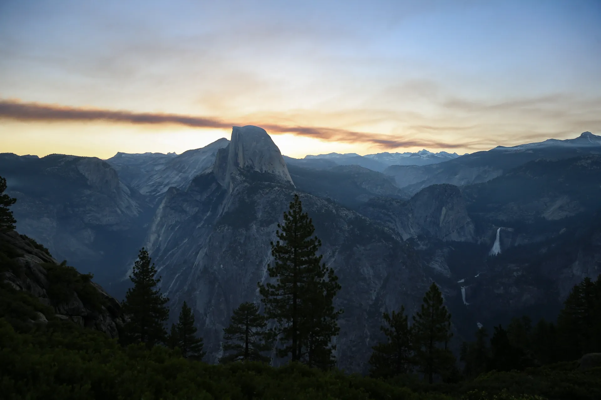
Vernal Fall and Nevada Fall, Mist Trail (7.1 miles round trip, 1,900 ft gain)
The Mist Trail is the Valley's classic waterfall hike and one of the best trails in California. It follows the Merced River from Happy Isles (Valley shuttle stop 16) up through Little Yosemite Valley. The first mile is a paved climb to the Vernal Fall footbridge, a popular turnaround point. Continuing up the Mist Trail itself takes you up steep granite steps past the spray zone of Vernal Fall (bring a rain jacket, you will get soaked in spring) to the top of Vernal Fall at 317 feet, then up again to the top of Nevada Fall at 594 feet. The view from the top of Nevada Fall, looking down the Merced River gorge with Half Dome visible above, is one of the most dramatic in the Valley.
Return via the John Muir Trail (slightly longer but drier) or back down the Mist Trail. The Mist Trail in spring runoff (April–June) is genuinely soaking, the spray from Vernal Fall covers the trail. Light rain gear is appropriate unless you actively want to be wet.
Four Mile Trail to Glacier Point (9.6 miles round trip, 3,200 ft gain)
Glacier Point is the iconic Yosemite viewpoint, direct line-of-sight to Half Dome, Yosemite Falls, and the full Valley spread 3,214 feet below. You can drive or take a tour bus to Glacier Point (summer only), but hiking up the Four Mile Trail earns the view differently. The trail climbs relentlessly up the Valley's south wall. The payoff at the top is one of the best viewpoints in the Sierra. Return the same way or arrange a shuttle from the Valley to pick you up at Glacier Point for a one-way descent (check Yosemite's transportation page for current options).
Half Dome: The Big One
Half Dome requires a permit that's separate from the Valley day-use reservation and is arguably the most competitive permit in the National Park System. The hike is 14–16 miles round trip with 4,800 feet of gain, following the Mist Trail to Little Yosemite Valley and then climbing the Half Dome cables to the summit at 8,836 feet. The cables (steel ropes alongside granite slabs at a 45-degree angle) are installed late May through mid-October. Off the cables, the route is a technical rock climb.
Permit strategy: Apply in the preseason lottery (opens in March via recreation.gov) for weekday and weekend permits for the entire summer. If you miss the preseason lottery, daily permits are released 2 days before each hike date. The daily permits are extremely competitive, check recreation.gov at exactly midnight PT 2 days before your target date. Failing that, permits occasionally appear from cancellations throughout the day.
The hike itself: start at Happy Isles no later than 6am to beat crowds on the cables and afternoon thunderstorms on the exposed summit. The cables section takes 1–2 hours each way, gloves are strongly recommended (provided free at the base of the cables). The summit is expansive, 13 acres, with views of Tenaya Canyon, Little Yosemite Valley, and the High Sierra extending east. Lightning on the exposed summit kills hikers, if you see building thunderstorms, descend immediately.
What to Skip (or Manage Expectations On)
Bridalveil Fall viewpoint: It's impressive and worth 5 minutes, but it's the most crowded single spot in the Valley. Visit on weekdays or very early morning. The fall itself runs year-round but is most dramatic in spring.
Valley View pullout: Beautiful Merced River-and-Valley view from a roadside turnout. Excellent in 2 minutes, not a hiking destination. Stop here entering or leaving the Valley.
Ahwahnee area walks: The area around the historic Ahwahnee Hotel has pleasant meadow walks with great Half Dome views. Under-visited relative to the rest of the Valley. Cook's Meadow Loop (1.2 miles) at dawn is one of the finest short walks in the park.
When to Go
April–May: Peak waterfall season, highest flow from snowmelt. Mist Trail is spectacular. Cold mornings (30s in early April, 50s by May). Yosemite Falls at full roar. High demand for reservations.
June–July: Summer hiking at its best, warm but not brutal in the Valley, wildflowers at Glacier Point. Half Dome cables open. Extremely busy. Arrive early for everything.
September–October: Best overall conditions. Crowds thin noticeably after Labor Day. Temperatures perfect for strenuous hikes (60s–70s in the Valley). Fall color in Tenaya Canyon in October. Waterfalls lower but still running.
November–March: Valley reservation system doesn't apply, no permit needed for vehicle entry. Dramatically fewer crowds. Snow and ice on trails above 5,000 feet. Yosemite Falls may freeze. The Valley in winter light is extraordinary.
Getting Around the Valley
The Valley Shuttle is free and connects all major trailheads, lodges, campgrounds, and viewpoints within the Valley. In peak season, parking at trailheads is impossible, the shuttle is the only realistic way to reach many trailheads. Shuttle stops are numbered 1–21 and the system runs every 10–20 minutes. Learn which stop serves which trailhead before your hike.
For hikes starting outside the Valley (Glacier Point Road, Tioga Road, Tuolumne Meadows), separate tour buses and hikers' buses run in summer, check yosemite.com for schedules and book in advance.


