
Yosemite Hiking Trips:
Best Trails & Complete Guide
Half Dome, the Mist Trail to Vernal & Nevada Falls, Mirror Lake, and the Valley Loop, the four Yosemite Valley routes most worth your time, with the shuttle, permit, heat-timing, and timed-entry logistics that make or break the day.
Free interactive planner · drag & reorder your days, add stops, map it in minutes
Build your own Yosemite hiking trip, drag, reorder & map it.
Drag hikes between days, swap a strenuous summit for an easy meadow loop, and add your own trailheads and overlooks with the place search. The live map and drive times recalculate as you go, and we'll warn you before you build a day no one finishes before dark.
Opens a side panel · reorder days, add custom stops, see your route live
The ultimate Yosemite Valley hiking guide.
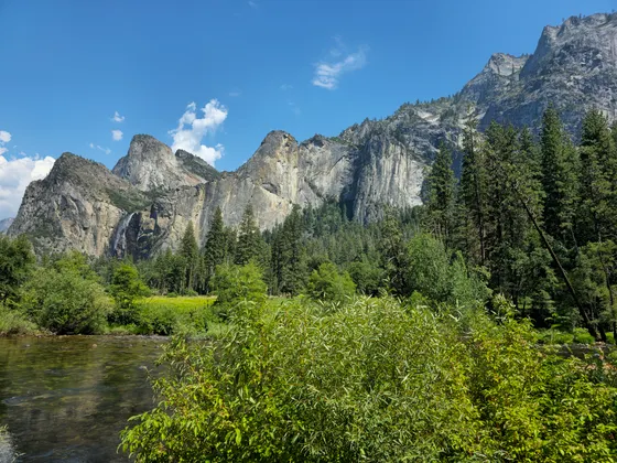
Yosemite Valley draws four million visitors a year, but the great hiking starts the moment you leave the road. This guide focuses on the four routes most worth your time on a first-or-second visit, and on the logistical traps (shuttle hours, peak-heat timing, seasonal trail closures, the timed-entry gate) that quietly turn good hikes into bad days. Every detail below reflects what's actually on the ground.
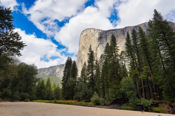
The headline hike is the Half Dome Day Hike (14 to 16 miles, 4,800 feet of gain, extremely strenuous), which requires a cables permit via lottery. The Mist Trail climbs past Vernal and Nevada Falls, Mirror Lake is the easy seasonal-pool walk, and the Valley Loop Trail delivers flat, scenic views up at El Capitan and Cathedral Rocks.
Two things make or break a Yosemite hiking day: the Timed Entry Reservation system on peak summer weekends and holidays, and the microclimate swing from the 4,000-foot Valley up to the 8,000 to 9,000-foot High Country. Pass through the gates before 5:00 AM or after 4:00 PM to beat the reservation checkpoints, and pack for two seasons if your trip climbs to Glacier Point or Tuolumne Meadows.
The Half Dome cables require a permit via a daily lottery, and rangers check at the Subdome, so plan permits well ahead or book a guided trip that pulls group permits. In-park lodging (Yosemite Valley Lodge and Curry Village) and the timed-entry reservation both sell out fast for prime summer dates, so reserve early or base in a gateway town like El Portal or Groveland and drive in.
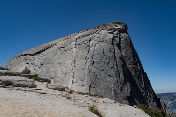
The Iconic Half Dome Day Hike
The headline hike is the Half Dome Day Hike: 14 to 16 miles depending on route, 4,800 feet of elevation gain, extremely strenuous, and 10 to 14 hours on your feet. The cables require a permit via lottery, and rangers check at the Subdome, so do not start up without one.
The 4:30 AM rule (don't wait for the shuttle). The free Yosemite Valley Shuttle does not begin service until 7:00 AM. Waiting for it means starting your hike dangerously late, forcing you onto the exposed Subdome during peak lightning-hazard hours (1:00 PM to 4:00 PM) and through the worst of the afternoon heat. Park at Curry Village or the Trailhead Parking Lot and walk the extra 0.75 miles to the Happy Isles Trailhead on foot in the dark.
Hydration strategy. Carry a minimum of 4.5 liters of water per person, or bring a reliable water filter so you can pump from the Merced River below Nevada Fall. Do not rely on the water spigot at the Vernal Fall Footbridge: it is seasonal and frequently shut off due to freezing or infrastructure issues. The descent rule. Because of severe afternoon congestion and safety hazards, park rangers frequently implement a mandatory one-way downward flow on the Mist Trail between 7:00 AM and 3:30 PM (typically July through October). Prepare your knees to descend via the longer, more exposed John Muir Trail (JMT) detour, which adds roughly 1.5 miles to your overall trek.
- 14 to 16 mi · 4,800 ft gain · extremely strenuous · 10 to 14 hr · cables permit via lottery
- Lasting Adventures · ~14 hr trip · guides pull group permits & supply harnesses, gloves & hydration support · pricing & dates on FareHarbor
- Carry 4.5 L or a filterPump from the Merced below Nevada Fall · the Vernal Fall Footbridge spigot is seasonal & often off
- Park at Curry Village & walk in by 4:30 AMShuttle starts at 7:00 AM · walk the extra 0.75 mi to Happy Isles Trailhead in the dark
- The free Yosemite Valley Shuttle does not start until 7:00 AM. Waiting for it puts you on the exposed Subdome during peak lightning hours (1:00 PM to 4:00 PM) and the worst afternoon heat, so park at Curry Village or the Trailhead Parking Lot and walk the extra 0.75 miles to Happy Isles in the dark.
- Carry a minimum of 4.5 liters of water per person, or a reliable filter to pump from the Merced River below Nevada Fall. Do not count on the Vernal Fall Footbridge spigot, which is seasonal and frequently shut off.
- Rangers frequently run a mandatory one-way downward flow on the Mist Trail between 7:00 AM and 3:30 PM (typically July through October), so plan to descend via the longer, more exposed John Muir Trail, which adds about 1.5 miles.
- If the cable-permit lottery is the thing standing between you and the summit, a local guiding outfit pulls group permits ahead of time and supplies harnesses, gloves, hydration support, and a guide on the cables, worth it for first-timers, solo travellers, and anyone who didn't win the daily lottery.

The Mist Trail (Vernal & Nevada Falls Loop)
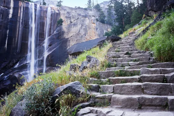
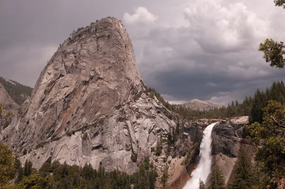
The Mist Trail is the classic Valley waterfall climb: 5.4 miles for the full loop, 2,000 feet of elevation gain, strenuous, 3 to 5 hours, and no permit required. It climbs past Vernal Fall and on up to Nevada Fall.
The right footwear. The stone stairs leading up to Vernal Fall are constantly blasted with freezing river spray during spring and early summer. Standard running shoes will slip; hiking boots with sticky rubber outsoles and trekking poles are highly recommended.
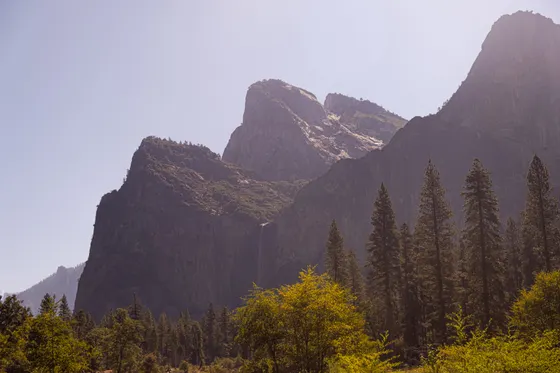
Seasonal detours. During peak maintenance season (mid-summer through fall), the section of the Mist Trail from the top of Vernal Fall to Nevada Fall is often closed to downhill traffic during the day. You must hike up the Mist Trail steps but descend via the John Muir Trail. This alternative route offers phenomenal panoramic views of Liberty Cap and the back of Half Dome, but it increases your hiking time and distance.
- 5.4 mi full loop · 2,000 ft gain · strenuous · 3 to 5 hr · no permit
- Often required mid-summer through fall · panoramic views of Liberty Cap & the back of Half Dome
- Sticky-soled boots & trekking polesThe stone stairs to Vernal Fall are blasted with freezing spray in spring & early summer
- The stone stairs up to Vernal Fall are constantly blasted with freezing river spray in spring and early summer. Running shoes slip, so wear hiking boots with sticky rubber outsoles and bring trekking poles.
- Mid-summer through fall the section from the top of Vernal Fall to Nevada Fall is often closed to downhill traffic during the day. Hike up the Mist Trail steps but descend via the John Muir Trail, which adds time and distance.
- The John Muir Trail descent is not a penalty: it offers phenomenal panoramic views of Liberty Cap and the back of Half Dome.
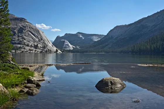
Mirror Lake Trail
The Mirror Lake Trail is the easy one: 2 miles to the lake and back, or 5 miles for the full meadow loop, with only 200 to 300 feet of (flat) elevation gain, easy, 1 to 3 hours, and no permit required.
The "Mirror Meadow" illusion. Do not expect a pristine lake year-round. Mirror Lake is a seasonal pool filled by snowmelt. It is spectacularly full from April through June. By late July, August, and September, the lake completely evaporates, turning into a dry, sandy meadow. Adjust your expectations based on the month you visit.
Correction on trail specs. Some online logs list this trail with a 900-foot elevation gain, that's inaccurate. The loop hugs the floor of Tenaya Canyon and stays nearly flat. It's a gentle walk, not a mountain climb.
- 2 mi to the lake & back · 5 mi full meadow loop · 200 to 300 ft (flat) · easy · 1 to 3 hr · no permit
- Visit April through June for the lakeSeasonal snowmelt pool · full April to June · a dry sandy meadow by late July, August & September
- Mirror Lake is a seasonal pool filled by snowmelt. It is spectacularly full from April through June, but by late July, August, and September it completely evaporates into a dry, sandy meadow, so set your expectations by the month you visit.
- Some online logs list a 900-foot elevation gain for this trail, which is inaccurate. The loop hugs the floor of Tenaya Canyon and stays nearly flat. It is a gentle walk, not a mountain climb.

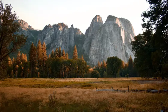
The Valley Loop Trail & El Capitan View
The Valley Loop Trail is the flat, scenic alternative: 6.5 miles for the half loop or 13 miles for the full loop, mostly flat, moderate (due to distance, not steepness), about 3 to 4 hours for the half loop, and no permit required.
Trail clarity. This trail is a low-impact, scenic alternative to the steep granite stairs of the canyon walls. It offers unparalleled views looking up at El Capitan and Cathedral Rocks.
Pacing reality. Don't confuse this flat valley-floor trail with the grueling El Capitan Summit Hike (which leaves from Tamarack Flat or Upper Yosemite Falls and takes 8 to 10 hours of intense vertical climbing). The Valley Loop can easily be done in a morning, leaving your afternoon open for other activities.
- 6.5 mi half loop · 13 mi full loop · mostly flat · moderate (distance, not steepness) · 3 to 4 hr half loop · no permit
- Unparalleled views looking up at El Capitan and Cathedral Rocks from the Valley floor
- This is a low-impact, scenic alternative to the steep granite stairs of the canyon walls, with unparalleled views looking up at El Capitan and Cathedral Rocks.
- Do not confuse the flat valley-floor Valley Loop with the grueling El Capitan Summit Hike, which leaves from Tamarack Flat or Upper Yosemite Falls and takes 8 to 10 hours of intense vertical climbing.
- The Valley Loop can easily be done in a morning, leaving your afternoon open for other activities.
Now build your Yosemite trip.
You've seen all four signature hikes. Open the free drag-and-drop planner and tune it for your dates, your pace, and whether you base in Yosemite Valley Lodge, Curry Village, or a gateway town.
What actually makes or breaks a Yosemite hiking day.
The peak-hour reservation bottleneck
During peak summer weekends and holidays, Yosemite operates a Timed Entry Reservation system. If your itinerary says to start hiking at 8:30 AM, you cannot arrive at the park gates at 8:00 AM: the entrance lines routinely stretch up to two hours long.
The fix: beat the gates
Pass through the physical park entrance gates before 5:00 AM or after 4:00 PM. This bypasses the reservation checkpoints and guarantees a spot in the Valley parking lots, which are completely full by 7:30 AM.
High Country vs. Valley microclimates
If your trip takes you from Yosemite Valley (4,000 ft) up to Glacier Point or Tuolumne Meadows (8,000 to 9,000 ft), pack for two completely different seasons. The High Country can be 20 to 30°F cooler than the Valley.
Pack for sudden alpine storms
A sudden afternoon alpine thunderstorm can drop temperatures rapidly. Always carry a windproof/waterproof jacket and an insulating layer in your daypack, even when the Valley reads sunny and 85°F at sunrise.
Everything you'll actually want to know.
Ready to go? Get your
Yosemite hiking route.
Trailheads and mileages, the Half Dome permit and shuttle timing, the timed-entry gate, water strategy, and the seasonal closures you need to hike Yosemite Valley safely.
Pricing & dates on FareHarbor · Free cancellation policy varies · book ahead


Planning this trip?
Save it, share it with your crew, or find travelers heading the same way.

Liked this itinerary?
What other travelers are saying
Be the first to leave a tip or question for the next traveler.