
John Muir Trail Section Hike:
A 5-Day Sierra Itinerary
A 5-day John Muir Trail section hike from Tuolumne Meadows in Yosemite over 11,073-foot Donohue Pass and through the Ansel Adams Wilderness to Thousand Island Lake, the Devils Postpile, and Reds Meadow near Mammoth.
Free interactive planner · drag & reorder your days, add stops, map it in minutes
Build your own JMT section hike, drag, reorder & map it.
Drag camps between days, swap a pass or a lake, and add your own side trips with the place search. The live map and mileages recalculate as you go, and we'll warn you before you build a day that means too many miles and too much vertical above 10,000 feet.
Opens a side panel · reorder days, add custom stops, see your route live
One classic section, a high pass, alpine lakes & granite, on the JMT.
The John Muir Trail runs 211 miles from Happy Isles in Yosemite Valley to the summit of Mount Whitney, the highest point in the lower 48. It threads Yosemite, the Ansel Adams Wilderness, the John Muir Wilderness, and Kings Canyon and Sequoia National Parks, climbing over a chain of 11,000 to 13,000-foot passes: Donohue, Silver, Selden, Muir, Mather, Pinchot, Glen, and Forester. The full trail takes most hikers about three weeks, which is why a JMT section hike is how the great majority of people experience it.
This 5-day section covers one of the most scenic and accessible stretches: from Tuolumne Meadows in Yosemite, south over 11,073-foot Donohue Pass and into the Ansel Adams Wilderness, past Thousand Island Lake and the Garnet Lake basin beneath Banner and Ritter, then down to the Devils Postpile and Reds Meadow near Mammoth Lakes. It is roughly 38 miles of granite, alpine lakes, and reflected peaks, with a road-accessible finish.
July through September is the prime window, when the high passes are largely snow-free. In early summer the passes can still hold snow and the creek crossings run high and cold, so check current conditions before you go. This is strenuous backpacking at altitude. Spend a night or two acclimatizing in Mammoth or Bishop first, carry a bear canister, and remember a wilderness permit is required and competitive.
A wilderness permit is required for this section and the Yosemite JMT and trailhead quotas are competitive, so apply early through recreation.gov. A bear canister is required to store all food. Plan your resupply at Reds Meadow, Vermilion Valley Resort, or Muir Trail Ranch if you continue south. Lodging in Mammoth Lakes and Bishop fills up on summer weekends, so book your before-and-after nights ahead.


Tuolumne Meadows & up Lyell Canyon
Start where the high country opens up. Tuolumne Meadows sits at about 8,600 feet on the Tioga Road in Yosemite, an easy launch point that lets you skip the long, hot climb out of Yosemite Valley. Pick up your wilderness permit, top off water, and store everything edible in your bear canister before you walk out of the trailhead.
The first day eases you in along the Lyell Canyon stretch of the John Muir Trail, a gentle, nearly flat walk beside the meandering Lyell Fork of the Tuolumne River, with granite domes and meadows on either side. Camp in the upper canyon, below the climb to Donohue Pass, so you start the big ascent fresh in the morning. This is a good first day to settle into the altitude.
- Gentle riverside start · easy grade · settle into altitude
- Required · reserve ahead on recreation.gov · pick up at the permit office
- Camp in upper Lyell CanyonBelow Donohue Pass · start the climb fresh tomorrow
- Filter water from the Lyell ForkPlentiful river water · treat or filter everything
- Tuolumne Meadows is reachable by the Tioga Road (Highway 120), which is only open in summer and fall once it is plowed, usually late May or June. Confirm the road is open before you drive in.
- A wilderness permit is required and competitive. Reserve through recreation.gov well ahead, and pick up the physical permit at the Tuolumne Meadows permit office.
- Store all food, trash, and scented items in an approved bear canister. It is required throughout this section and rangers do check.
Lyell Canyon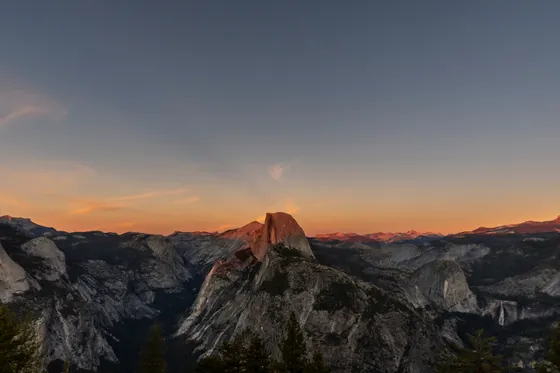 On the trail
Over Donohue Pass into the Ansel Adams Wilderness
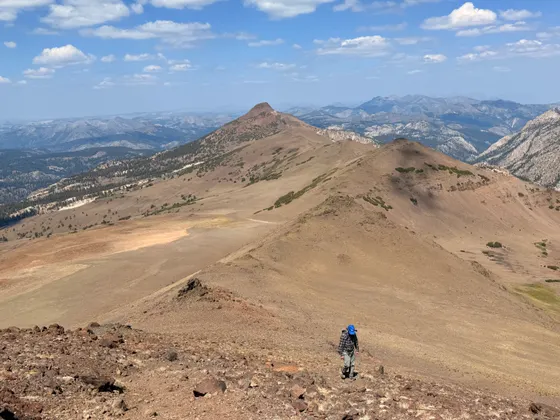
 High Sierra pass
 Alpine lake
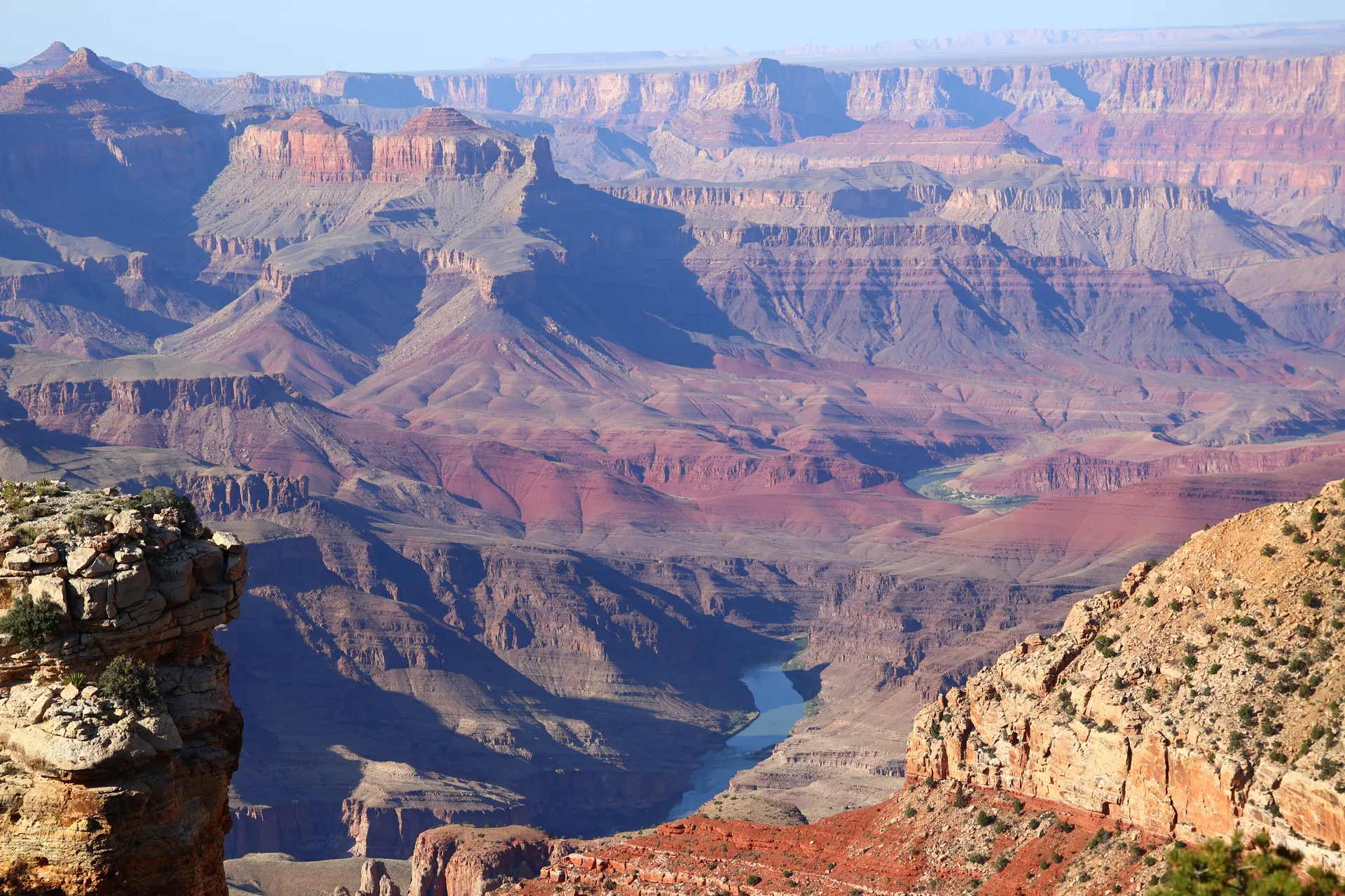
Today is the section's first big climb. The trail rises out of Lyell Canyon to Donohue Pass at 11,073 feet, the boundary between Yosemite and the Ansel Adams Wilderness and the spot where the Yosemite permit exit quota is enforced. Pace yourself on the switchbacks, drink often, and take in the view back over the Lyell Fork and ahead into a wilder, more rugged stretch of the Sierra.
Descend the south side into the Ansel Adams Wilderness, a landscape of polished granite, tarns, and big peaks. Drop through Rush Creek country toward the Island Pass area and set up camp with Banner and Ritter beginning to fill the skyline. In early summer the snow lingers up high and the creek crossings run cold and strong, so cross in the morning when flows are lowest.
- 11,073 ft · Yosemite boundary · exit quota enforced here
- Granite, tarns & big peaks · managed by Inyo National Forest
- Cross creeks in the morningHigh, cold flows in early summer · lowest in the cool morning
- Camp toward Island PassBanner & Ritter on the skyline · set up before afternoon storms
- Donohue Pass is where the Yosemite JMT permit exit quota applies. Your permit must allow you to exit Yosemite over Donohue, so confirm the wording when you reserve.
- High-altitude afternoon thunderstorms are common in the Sierra in summer. Get over the pass by midday and aim to be in camp before storms build.
- In early summer the passes hold snow and creek crossings run high and cold. Check current conditions, and consider an ice axe and traction if snow lingers.
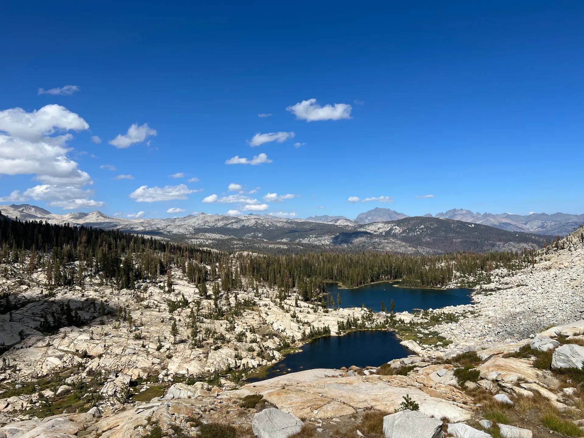
Thousand Island Lake & the Garnet Lake basin
This is the postcard day. The trail reaches Thousand Island Lake, a broad alpine lake scattered with tiny islands directly beneath the dark spire of Banner Peak, one of the most photographed scenes in the entire Sierra. Linger for the morning light, then continue past Garnet Lake, an equally stunning basin a little farther on, with Banner and Ritter rising straight from the water.
The JMT and the parallel Ritter Range trails weave through this lake country, rolling over small ridges between basins. Camp limits keep tents back from the most fragile shorelines, so check the posted rules and camp on durable ground. Take it slow today: the scenery is the whole point, and the mileage is modest enough to let you swim, photograph, and simply sit by the water.
- Banner Peak reflected · the iconic Ansel Adams Wilderness view
- Banner & Ritter from the water · another stunning basin
- Modest mileage · short climbs between lakes · a slow scenic day
- Camp on durable groundRespect shoreline camp limits · camp back from fragile edges
- Camping is restricted near the outlet of Thousand Island Lake and along fragile shorelines. Read the posted limits and camp on durable surfaces well back from the water.
- Morning light on Banner Peak over Thousand Island Lake is the classic shot. If photography matters to you, camp close enough to be there at first light.
- This is a short-mileage day by design. Use the spare time to acclimatize, swim, and rest your legs before the descent toward Reds Meadow.
Garnet LakeGranite basinsDown toward the Devils Postpile & Reds Meadow
 Descent to the valleyNearing Reds Meadow
Today the trail trends downhill, leaving the high lake basins and descending through forest toward the Middle Fork of the San Joaquin. The grade eases and the air thickens as you lose elevation, a welcome change after days up high. Keep your eyes on the peaks behind you and your feet on the rocky, rooty tread as the trail loses altitude steadily.
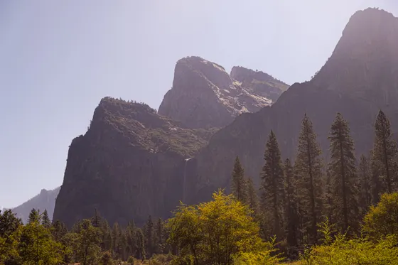
You approach the Devils Postpile National Monument, a striking wall of hexagonal basalt columns formed by cooling lava, just off the JMT and well worth the short detour. From there it is a short walk to Reds Meadow, a road-accessible resupply point with a small store, cafe, and the nearby hot springs. Many section hikers resupply at Reds Meadow, mail a box ahead, or end their trip here. Camp nearby for your last night on the trail.
- Hexagonal basalt columns · short detour off the JMT
- Small store & cafe · mail a resupply box ahead · road-accessible
- Reds Meadow hot springsA soak after days on the trail · near the resort and shuttle
- Last night near Reds MeadowRoad-accessible · close to the Mammoth shuttle for tomorrow
- Reds Meadow is a classic JMT resupply. You can mail a box ahead to the resort or buy a limited resupply at the small store. Confirm the resort's seasonal operating dates first.
- The Devils Postpile is a short, worthwhile detour off the trail. The basalt columns and the view from on top are among the best roadside-accessible sights in the eastern Sierra.
- In summer the Reds Meadow road requires a shuttle from Mammoth Mountain for most of the day. Check the current shuttle schedule if you plan to exit or be picked up here.
Out to Mammoth Lakes & onward
Wrap up the section with the short final miles out and the ride back to civilization. From Reds Meadow the Mammoth Mountain shuttle runs up to the Mammoth Mountain Adventure Center, where you can grab a real meal, a shower, and a bed in Mammoth Lakes. After days above 10,000 feet, the town's restaurants and hot showers feel like a luxury.
Getting home: Mammoth Yosemite Airport (MMH) has seasonal flights, or it is roughly 3 hours to Reno (RNO) over the Sierra, and longer to Fresno (FAT) on the west side. If you have a permit and the legs, this same section connects seamlessly to the JMT continuing south toward Vermilion Valley Resort, Muir Trail Ranch, and ultimately Muir Pass and Mount Whitney, so it makes a natural building block for a longer thru-hike.
- Mammoth shuttle to Mammoth LakesReds Meadow to the Adventure Center · summer shuttle service
- Restaurants, lodging & gear shops · the eastern Sierra hub
- Getting home: MMH, Reno or FresnoMammoth (MMH) seasonal · Reno (RNO) ~3 hr · Fresno (FAT) west side
- Vermilion Valley, Muir Trail Ranch & Muir Pass lie ahead
- The Reds Meadow shuttle from Mammoth Mountain is mandatory during operating hours in summer. Time your exit to the schedule, or arrange a pickup in the early morning before the road restriction starts.
- Mammoth Lakes is the obvious place to clean up, eat, and resupply. Book a room ahead on summer weekends, when the town fills with hikers and bikers.
- If you want to extend the trip, this section links directly to the rest of the JMT heading south. Plan resupply at Vermilion Valley Resort or Muir Trail Ranch and secure a Whitney exit permit if you intend to finish the whole trail.
Passes ahead Muir Pass · further south
Now build your JMT section hike.
You've seen all five days. Open the free drag-and-drop planner and tune it for your permit dates, your pace at altitude, and whether you base in Mammoth Lakes, Lee Vining, or Bishop before and after the trail.
What we actually learned on the trail.
A wilderness permit is required
You need a wilderness permit for any overnight on the John Muir Trail, and the Yosemite JMT and trailhead quotas are competitive. Apply early through recreation.gov, and if you plan to exit over Donohue Pass or finish at Mount Whitney, make sure your permit covers those quota points.
Carry an approved bear canister
A bear canister is required throughout this section to store all food, trash, and scented items. Black bears are active and clever in the Sierra. Pack a canister that fits your trip length, and never leave food in your tent or pack overnight.
Plan your resupply
For a 5-day section you can carry all your food, but for longer JMT trips resupply at Reds Meadow, Vermilion Valley Resort, or Muir Trail Ranch. Mail boxes ahead where allowed, confirm each spot's seasonal dates, and account for the cost of holding and forwarding fees.
Hike July through September
The high passes are largely snow-free from about July into September, the prime window for this section. In early summer the passes hold snow and the creek crossings run high and cold. Always check current conditions on the Inyo National Forest and Yosemite sites before you go.
Acclimatize before you climb
This is strenuous backpacking with passes from 11,000 feet and up. Spend a night or two acclimatizing in Mammoth Lakes or Bishop first, climb slowly, drink plenty of water, and watch for the headache and nausea of altitude sickness on the high days.
Plan around afternoon storms
Sierra thunderstorms build fast on summer afternoons. Get over the high passes by midday, avoid exposed ridges when storms threaten, and have a plan to drop to lower, sheltered ground if lightning rolls in.
Everything you'll actually want to know.
Ready to go? Get your
JMT section route.
Trailheads and mileages, the Donohue Pass exit quota, bear-canister and resupply logistics, the Reds Meadow shuttle, and the permit steps you need to hike this John Muir Trail section safely.
Instant book · Free cancellation · Secure payment via Stripe
Know these trails yourself? Become a local guide and host free community hikes.

Planning this trip?
Save it, share it with your crew, or find travelers heading the same way.
What other travelers are saying
Be the first to leave a tip or question for the next traveler.
How was your experience?
Tell us what worked and what did not. It goes straight to Yulia and Margarita.