Kings Canyon Backpacking:
A 4-Day Sierra Itinerary
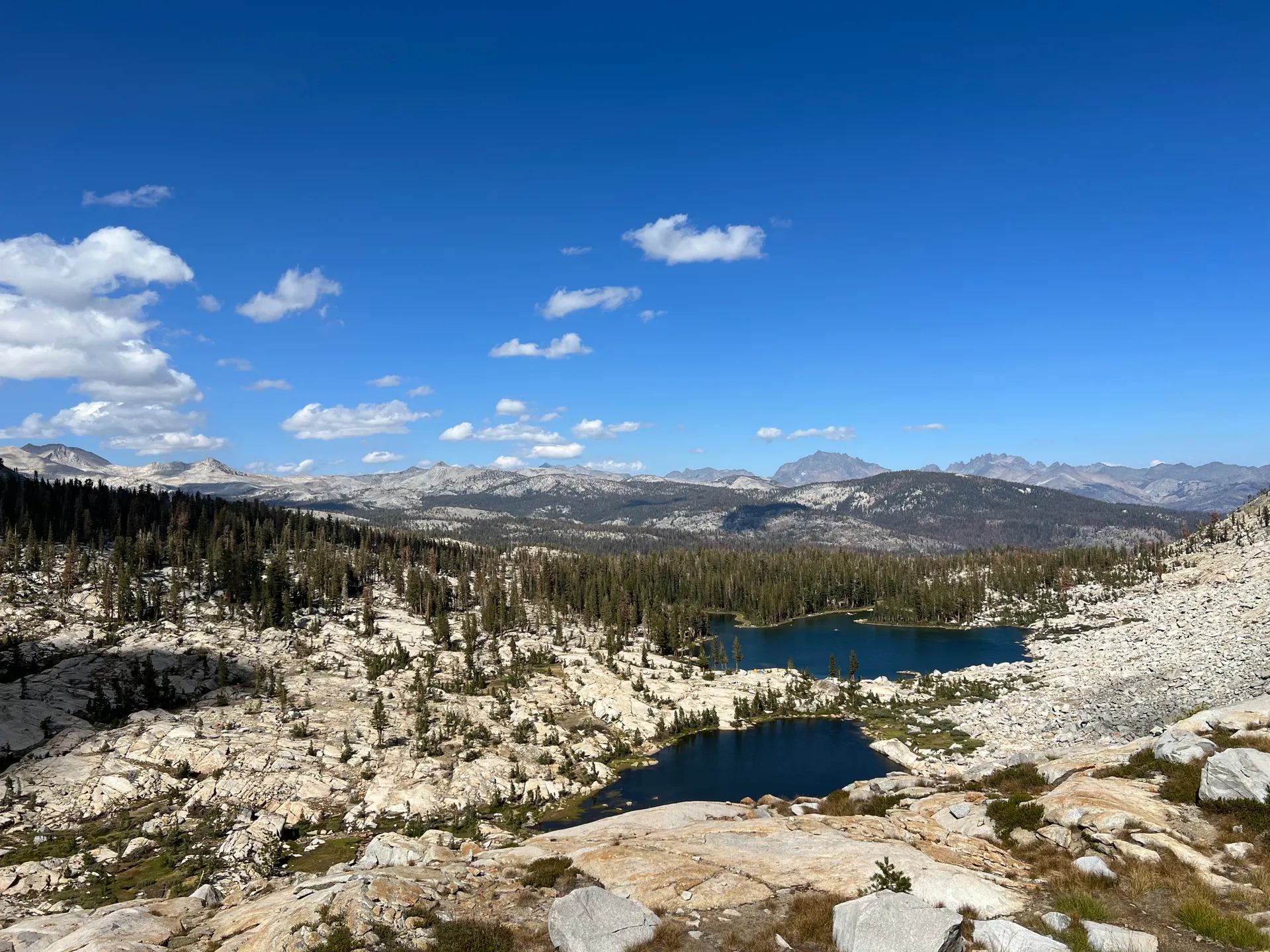
Four days backpacking the classic Rae Lakes Loop in Kings Canyon National Park: ~41 miles from Roads End over Glen Pass at 11,978 feet, past Rae Lakes, Charlotte Lake, and the Woods Creek suspension bridge.
Free interactive planner · drag & reorder your days, add stops, map it in minutes
Build your own Kings Canyon trip, drag, reorder & map it.
Drag camps between days, swap a lake for a meadow, and add your own side trips with the place search. The live map and daily mileage recalculate as you go, and we'll warn you before you stack too much vertical and too many miles into one day at altitude.
Opens a side panel · reorder days, add custom stops, see your route live
One loop, granite, glacial lakes & a high pass, deep in the Sierra.
The Rae Lakes Loop is the classic Kings Canyon backpacking trip: roughly 41 miles from Roads End in Cedar Grove, climbing out of the South Fork Kings River canyon, over Glen Pass at 11,978 feet, past the turquoise Rae Lakes, Charlotte Lake, and Vidette Meadow, then back down Bubbs Creek to where you started. Most people take four or five days, and the scenery rarely lets up.
You are walking through the granite heart of the Sierra Nevada, above one of the deepest canyons in the United States, carved by the South Fork of the Kings River. The route crosses the John Muir and Pacific Crest trails, drops over the dramatic Woods Creek suspension bridge, and camps beside alpine lakes that mirror the peaks. It is a strenuous loop with real altitude, but it is one of the best multi-day backpacking trips in the range.
July through September is the prime window. The road into Kings Canyon and the Roads End trailhead are seasonal, usually open from late April to mid November and closed all winter, and the high passes hold snow into early summer. Acclimatize before you go high, treat all your water, and be off the passes before the afternoon thunderstorms build.
A wilderness permit is required for the Rae Lakes Loop and there is a quota, so reserve through recreation.gov well ahead, especially for summer weekends. A bear canister is mandatory and you must carry all your food in it. The road into Kings Canyon and the Roads End trailhead are seasonal, so confirm they are open for your dates before you commit.


Roads End to Paradise Valley · up the South Fork
Pick up your permit and start at Roads End in Cedar Grove, deep in the granite canyon of the South Fork Kings River. Most loop hikers go counterclockwise, up the Woods Creek (Paradise Valley) side first to save the steepest climbing of Glen Pass for a fresh day. The trail follows the river through the lower canyon, then climbs the granite staircase of Mist Falls before easing into the meadows and pines of Paradise Valley.
Aim to camp in or just past Paradise Valley, roughly 9 to 10 miles in, beside the South Fork. This is a long but mostly gentle first day with one real climb at Mist Falls. Settle camp early, hang nothing and stash everything in your bear canister, and treat water from the river before you cook. You are still relatively low here, so it is a good night to start acclimatizing before the loop climbs into the high country.
- Seasonal trailhead · pick up your wilderness permit · loop start
- Mist Falls & the South Fork Kings RiverGranite-staircase climb · waterfall · treat all water
- Camp in Paradise Valley~9–10 mi in · riverside meadows · bear canister mandatory
- Quota · reserve ahead on recreation.gov · carry your permit
- A wilderness permit is required and there is a quota. Reserve through recreation.gov well ahead, and pick up the physical permit before you start at Roads End.
- Go counterclockwise (up the Woods Creek side first) so you climb Glen Pass on a fresh morning rather than at the end of a long day.
- A bear canister is mandatory on this loop. All food, trash, and scented items must fit inside it, so pack and plan your menu accordingly.
Woods Creek suspension bridge to Rae Lakes
Woods Creek bridge Alpine meadow
Climb steadily up the Woods Creek drainage to the famous Woods Creek suspension bridge, a long, bouncy single-file span over the creek where the John Muir and Pacific Crest trails join the loop. Beyond the bridge the trail rises through alpine meadows and granite benches, with peaks closing in on every side, toward the turquoise basin of the Rae Lakes.
Camp at Rae Lakes, roughly 8 to 9 miles on, beneath the Painted Lady and a ring of Sierra summits reflected in the water. This is the scenic high point of the trip and a wonderful place to spend the night, or a full layover day if you have the time. Note the established sites and the one-night camping limit at the lakes, store everything in your bear canister, and watch the sky so you can be over Glen Pass early tomorrow, before any afternoon storms.
- Single-file bouncy span · JMT / PCT junction · one at a time
- Rae Lakes basinTurquoise alpine lakes · the Painted Lady · reflected peaks
- Camp at Rae Lakes~8–9 mi · scenic high point · note the one-night limit
- Watch the afternoon skyPlan to cross Glen Pass early tomorrow before storms build
- The Woods Creek suspension bridge is single file and bounces. Cross one person at a time with your hip belt unbuckled in case you need to ditch the pack.
- Rae Lakes is the scenic heart of the loop. There is a one-night camping limit and established sites, so camp on durable ground and pack out everything.
- Glen Pass is your big climb tomorrow. Get an early start so you are over the top before the typical early-afternoon thunderstorms move in.
Over Glen Pass · Charlotte Lake & Vidette Meadow
This is the big day. Climb the switchbacks above Rae Lakes to Glen Pass at 11,978 feet, the high point of the loop, on a narrow rocky crest with a long view back over the lakes and ahead into the upper Bubbs Creek country. It can hold snow into early summer, so check conditions, pace yourself at altitude, and be over the top early to stay ahead of the weather.
On the far side the trail drops toward the junction for Charlotte Lake, a worthwhile short side trip and a fine camp, then continues down into Vidette Meadow on Bubbs Creek. Plan to camp around Vidette Meadow or Charlotte Lake, roughly 8 to 9 miles for the day. You have crossed the pass and the hardest climbing is behind you, with a long, scenic descent along Bubbs Creek waiting tomorrow.
- High point of the loop · rocky crest · may hold snow early season
- Charlotte LakeShort side trip off the loop · alpine lake · good camp
- Camp at Vidette Meadow~8–9 mi · on Bubbs Creek · below the pass
- Cross the pass earlyBeat the afternoon storms · pace yourself at altitude
- Glen Pass holds snow into early summer. In a big snow year you may want an ice axe and the skills to use it, so check current conditions before your trip.
- Pace yourself on the climb and drink steadily. At nearly 12,000 feet, going slow and steady is faster than stopping to recover from altitude.
- Charlotte Lake is a short detour off the main loop and makes a beautiful, quieter camp if you want to break up the descent.
 Charlotte LakeVidette Meadow
Down Bubbs Creek back to Roads End
 South Fork Kings River
 Loop complete
Close the loop with a long, scenic descent down Bubbs Creek, dropping out of the high country through forest and granite back to the South Fork canyon. The trail rejoins the river and follows it the final miles to Roads End, completing the roughly 41-mile loop where you started. It is mostly downhill, but it is a real day of about 12 miles, so start in good time and keep treating your water.
Getting home: from Roads End it is a long, winding drive out of Kings Canyon to the park entrance and on toward the gateway towns. Plan on roughly 2 hours from the park entrance area to Fresno (FAT), then add the long, slow drive in and out of the canyon itself, so leave with daylight to spare. Remember the canyon road is seasonal and can close, so confirm conditions before you count on it for your exit.
- Long downhill along the creek · forest and granite · treat water
- Close the loop at Roads End~12 mi day · back to the trailhead · ~41 mi total
- Getting home: drive out to Fresno (FAT)Long canyon road · ~2 hr to Fresno from the entrance · seasonal road
- The final day down Bubbs Creek is mostly downhill but still about 12 miles. Start early and keep treating water all the way out to the trailhead.
- The road into Kings Canyon is seasonal, usually open late April to mid November and closed in winter. Confirm it is open for your exit date.
- It is a long, winding drive out of the canyon. From the park entrance area it is roughly 2 hours to Fresno (FAT), so plan your flight or drive with plenty of buffer.
Now build your Kings Canyon trip.
You've seen all four days. Open the free drag-and-drop planner and tune it for your dates, your pace, and whether you run the loop in four days or take a relaxed five with a layover at the lakes.
What we actually learned on the loop.
Reserve a wilderness permit ahead
A wilderness permit is required for the Rae Lakes Loop and there is a quota. Reserve through recreation.gov well in advance, especially for summer weekends, and carry the physical permit. Pick it up before you start at Roads End.
A bear canister is mandatory
You must carry an approved bear canister and store all food, trash, and scented items inside it every night. Bears are active and well practiced here, so plan a menu that fits the canister and never leave food unattended.
Go July through September
July through September is the prime window. The high passes hold snow into early summer, and the road and trailhead are seasonal, usually open late April to mid November. Confirm both the road and the pass conditions before you commit to dates.
Acclimatize before the high country
Glen Pass tops out at 11,978 feet. Spend a night at altitude before the trip if you can, take the first day easy, pace yourself on the climb, and drink steadily. Altitude is the most common reason loops go sideways.
Treat all your water
There is plenty of water on the loop, from the Kings River to the alpine lakes, but treat all of it with a filter, purifier, or chemical drops. Camp at least 100 feet from water and wash well away from streams and lakes.
Cross the passes early
Afternoon thunderstorms are common in the Sierra in summer. Get an early start on the day you cross Glen Pass so you are over the exposed crest before the weather builds, and watch the sky as you climb.
Everything you'll actually want to know.
Ready to go? Get your
Kings Canyon backpacking route.
Trailhead, daily mileage, camps, permit and bear-canister rules, pass timing, the seasonal road, and drive times from Fresno, everything you need to backpack the Rae Lakes Loop safely.
Instant book · Free cancellation · Secure payment via Stripe
Know these trails yourself? Become a local guide and host free community hikes.


Planning this trip?
Save it, share it with your crew, or find travelers heading the same way.
What other travelers are saying
Be the first to leave a tip or question for the next traveler.
How was your experience?
Tell us what worked and what did not. It goes straight to Yulia and Margarita.