Titcomb Basin to the Cirque:
7 Days in the Winds
Seven days of serious alpine backpacking through the Winds: Titcomb Basin under Gannett Peak, Indian Basin, Island Lake, high passes, and the Cirque of the Towers, with the Wind River High Route as the ultimate version.
Free interactive planner · drag & reorder your days, add stops, map it in minutes
Build your own Wind River backpacking route, drag, reorder & map it.
Drag camps and passes between days, swap in a summit or a glacier side trip, and add your own lakes and trailheads with the place search. The live map recalculates as you go, and we'll flag a day that asks too much of you above 11,000 feet.
Opens a side panel · reorder days, add custom stops, see your route live
One range, granite spires, glaciers & alpine lakes, deep in Wyoming.
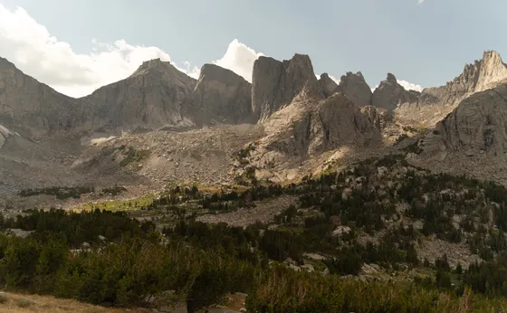
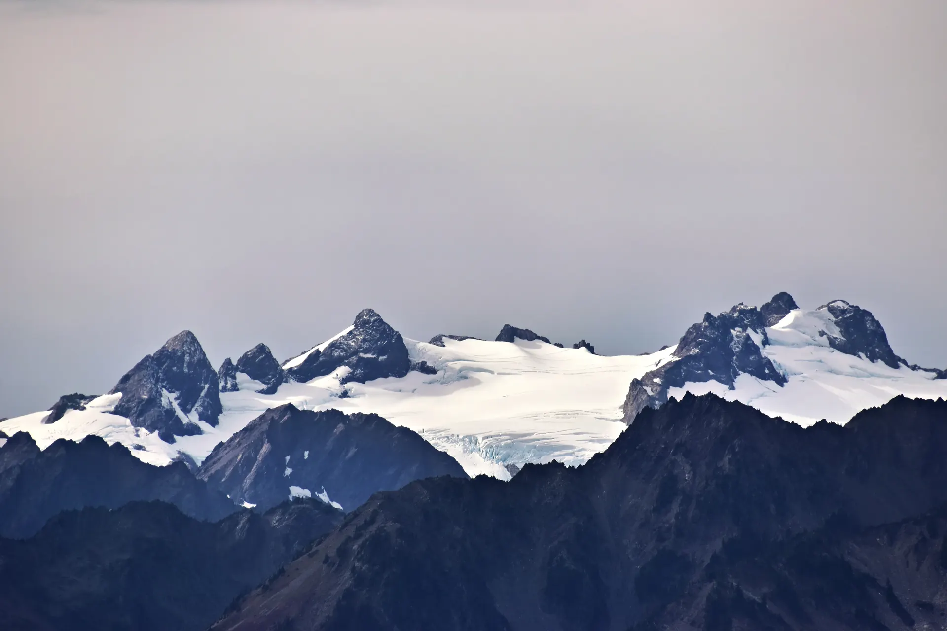
The Wind River Range is the wildest, highest stretch of the Rockies in Wyoming, a 100-mile granite spine that holds the state's tallest summit, Gannett Peak at 13,810 feet, plus the largest glaciers in the American Rockies and hundreds of alpine lakes. There are no roads through it and no resupply, which is exactly why a week here feels like crossing into a different country.
This 7-day route is built around classic Wind River Range backpacking: a Pinedale-side traverse from Elkhart Park up through Titcomb Basin under Fremont Peak and Gannett, over to Indian Basin and Island Lake, then across high passes south to the legendary Cirque of the Towers and out at Big Sandy. You'll carry seven days of food, with side options to climb a non-technical summit or walk up to a glacier viewpoint.
For experienced parties, the ultimate version is the off-trail Wind River High Route, roughly 80 to 100 miles of advanced cross-country travel that stays high the entire way, linking basin after basin over endless talus and unnamed passes. It is a serious undertaking with real route-finding, scrambling, and exposure, and a big step beyond this on-trail week.
This is remote alpine backpacking in grizzly country. Carry bear spray and a bear canister or a proper hang, self-register at the wilderness trailhead (free, no fee, with group-size limits), and plan for snow lingering on passes into July, ferocious mosquitoes in early summer, and near-daily afternoon thunderstorms. The best window is late July through mid September.
There is no resupply on this route, so you carry all seven days of food from the trailhead, and a bear canister or solid hang is essential in grizzly country. Trailhead permits are free, self-issued at the Bridger-Teton and Shoshone wilderness registers, with group-size limits you must follow. Snow can hold on the high passes into July, the mosquitoes are ferocious in early summer, and thunderstorms build most afternoons, so plan to be off the passes by early afternoon. Base nights are easiest from Pinedale (Elkhart Park) or Lander (Big Sandy); the nearest airports are Jackson (JAC) and Riverton (RIW).

Elkhart Park to Hobbs & Seneca Lakes
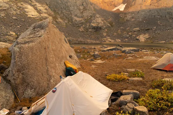
Drive up to the Elkhart Park trailhead above Pinedale, the classic Pinedale-side gateway into the Winds at about 9,300 feet. Sign in at the free wilderness self-registration board, note the group-size limits, and shoulder a full seven days of food before you start, because there is no resupply anywhere on this route.
Hike the Pole Creek and Seneca Lake trails through forest and granite benches, past Hobbs Lake and Seneca Lake, roughly 8 to 9 miles to a first camp near Seneca or Little Seneca Lake. Take it easy on day one to start acclimatizing, hang or canister your food well away from camp, and get used to moving in grizzly country with bear spray on your hip.
- ~9,300 ft · Pinedale-side gateway · free self-registration
- ~8-9 mi · forest, lakes & granite benches
- Carry bear spray & a canister or hangGrizzly country · no resupply · seven days of food
- Camp near Seneca LakeFirst night · start acclimatizing slowly
- Sign the free self-registration board at Elkhart Park and follow the posted group-size limits for the Bridger-Teton wilderness.
- There is no resupply on this route, so weigh your pack carefully and carry all seven days of food from the car.
- Take day one slow to start acclimatizing. Camp lower the first night and save the big elevation for once your body adjusts.
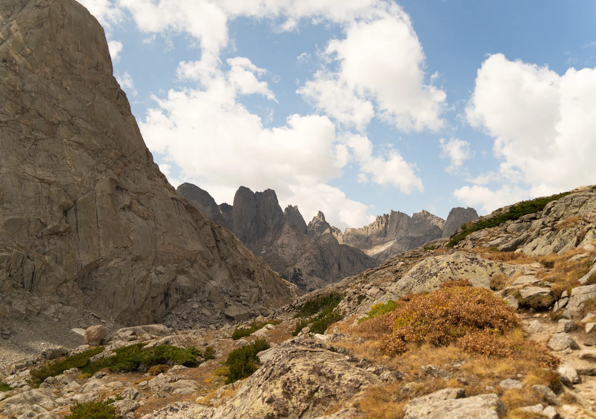
Island Lake & up into Titcomb Basin
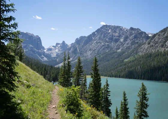
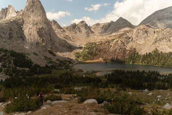
Climb past Seneca Lake to the Lester Pass junction and drop to Island Lake, one of the most photographed spots in the range, a long blue lake studded with rocky islets and ringed by jagged peaks. This is the gateway camp for Titcomb, and many parties base here for a night to set up day trips deeper in.
Push on up into Titcomb Basin, a soaring glacial valley walled by Fremont Peak, Mount Helen, and the spires of the Continental Divide, with Gannett Peak, the highest in Wyoming at 13,810 feet, rising just beyond. Make camp among the Titcomb Lakes at roughly 10,500 feet. Pick a tent site on durable ground, keep well back from the water, and watch the afternoon clouds, because storms build fast up here.
- Island LakeIconic blue lake & islets · gateway camp for Titcomb
- Glacial valley under Fremont Peak · Gannett beyond at 13,810 ft
- Titcomb Lakes camp~10,500 ft · durable ground · keep back from the water
- Watch the afternoon skyThunderstorms build fast · be off high ground early
- Island Lake is a stunning but popular camp. Spread out, camp on durable rock or established sites, and keep well back from the shoreline.
- Titcomb Basin sits high and exposed. Set your tent on durable ground and be ready for cold nights even in midsummer.
- Afternoon thunderstorms are near-daily. Plan basin and pass travel for the morning and have a plan to get low if lightning moves in.
Layover day · Indian Basin, a summit or a glacier
Keep your Titcomb camp and take a day pack to explore. Wander the head of Titcomb Basin to the upper lakes, or cross over to Indian Basin, a wide bench of granite slabs and turquoise tarns directly under the Continental Divide, one of the finest high camps and day-hikes in the entire range.
If you have the experience, this is the day for a side objective. Strong parties scramble a non-technical summit such as Fremont Peak, the third-highest in Wyoming, by its standard talus route, or walk up to a glacier viewpoint to see the largest glaciers in the American Rockies clinging to the high peaks. Keep any summit attempt early, carry the ten essentials in your day pack, and turn around well before the afternoon storms.
- Granite slabs & turquoise tarns under the Divide · superb day-hike
- Optional non-technical summite.g. Fremont Peak by its talus route · experienced parties only
- Glacier viewpointThe largest glaciers in the American Rockies · high under the peaks
- Second night in TitcombKeep the same base · day-pack the highlights
- A layover day in Titcomb lets you explore with a light pack and helps you acclimatize before the bigger passes ahead.
- Fremont Peak and similar summits are non-technical but involve loose talus and real exposure at altitude. Only attempt them if your party is experienced and the weather is settled.
- Even on a day hike, carry the ten essentials, bear spray, and plenty of water, and turn around well before the afternoon storms build.
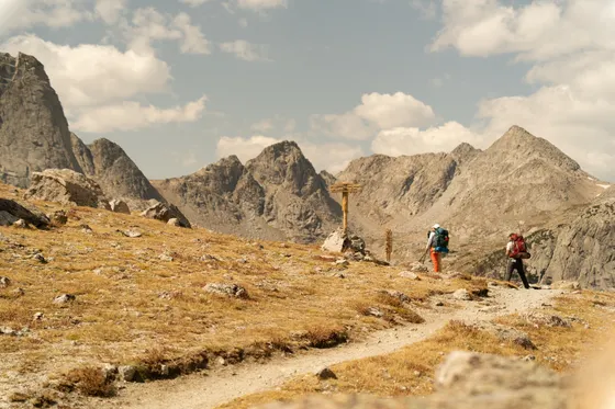
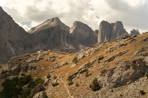
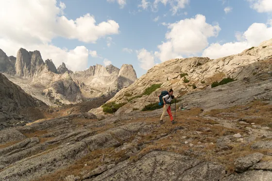
South over the high country toward Pole Creek
Pack up and turn south, beginning the long traverse toward the Cirque of the Towers. Drop back out of Titcomb past Island Lake and pick up the trails that thread the lake-dotted high country around Pole Creek and the upper Fremont drainage, climbing over a first high saddle into new basins.
This is big, remote terrain with several miles between water-friendly camps, so watch your map and your daylight. Expect roughly 9 to 11 miles with real elevation change, lingering snow on shaded north slopes early in the season, and almost no other people once you leave the Titcomb corridor. Make camp at a sheltered alpine lake and refill on water before the next climb.
- ~9-11 mi · lake-dotted high country · first big saddle
- Cross a high saddleSnow may linger on shaded slopes early season
- Refill at alpine lakesFilter or treat · plan water before each climb
- Camp at a sheltered lakeRemote terrain · few other parties
- The traverse south leaves the busy Titcomb corridor behind. Carry a paper map and compass and know how to use them, as cell service is nonexistent.
- Snow can linger on shaded passes and north slopes into July. An ice axe and the skills to use it are worth considering early in the season.
- Water sources are spread out on this stretch. Top off at lakes and streams and plan camps around reliable water.
Toward Big Sandy & Jackass Pass
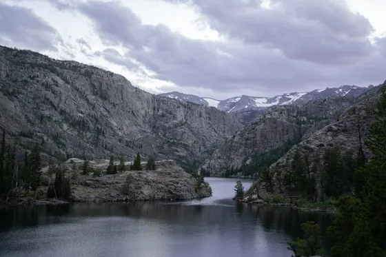
Continue south through the heart of the range toward the Big Sandy side, the southern gateway nearest Lander. The trail rolls through a string of classic Winds lakes and granite shelves, drawing closer to the spires that guard the Cirque, with the unmistakable profile of the towers beginning to fill the skyline ahead.
Set up at one of the alpine lakes below Jackass Pass, the rugged notch that is the key to the Cirque of the Towers. Camp short of the pass so you can cross it fresh and early, before the afternoon weather. Keep a clean camp, store food properly, and enjoy one of the wildest stretches of the whole traverse.
- Lakes & granite shelves · the towers come into view
- Camp below Jackass PassThe rugged notch into the Cirque · cross it fresh & early
- Keep a clean campStore food in a canister or hang · grizzly country
- Alpine lake campBelow the pass · one of the wildest stretches
- Camp below Jackass Pass so you can cross it early the next morning, when the rock is dry and the weather is calm.
- This is deep grizzly country. Cook away from your tent, store all food and scented items in a canister or proper hang, and keep bear spray within reach.
- The lakes below the Cirque are popular in peak season. Use established sites and practice strict Leave No Trace to protect the fragile alpine ground.
Over Jackass Pass into the Cirque of the Towers
Cross Jackass Pass early and drop into the Cirque of the Towers, the most famous amphitheater in the range, a horseshoe of soaring granite spires, Pingora, Wolf's Head, and the rest, wrapped around Lonesome Lake. For many backpackers this is the emotional high point of the entire Wind River Range, and a place rock climbers travel across the world to reach.
Spend the day soaking it in. Walk the shoreline, scramble onto a granite bench for the classic view across the lake to the towers, and watch climbers like ants on the walls. Camp at the required distance back from Lonesome Lake to protect the shore, keep your food secured, and savor a last night deep in the alpine before you walk out tomorrow.
- Cross early · drop into the Cirque of the Towers
- Cirque of the Towers & Lonesome LakePingora, Wolf's Head & the granite amphitheater
- Camp back from Lonesome LakeFollow the required setback to protect the shore
- Secure your foodCanister or hang · last night in the alpine
- Camping right at Lonesome Lake is restricted to protect the fragile shoreline. Camp back at the required distance and use established sites.
- Cross Jackass Pass early while the rock is dry and the weather is settled, then enjoy the Cirque through the afternoon from a safe, low camp.
- The Cirque is a major climbing destination as well as a backpacking one. Give climbers space and pack out absolutely everything you bring in.
Out via Big Sandy & the road to Lander
On the final day, climb back over the pass or take the alternate trail out and hike down to the Big Sandy trailhead through forest and meadow, roughly 9 to 10 miles, signing out at the wilderness register as you finish. After a week with no resupply and no cell service, the first cold drink in the trailhead lot tastes unreal.
Getting back: Big Sandy is the southern gateway nearest Lander, a great basecamp town for a celebratory burger and a real bed. From here it is a long but scenic drive to your airport, roughly 2 hours to Riverton (RIW) or about 2.5 to 3 hours back over to Jackson (JAC) and Pinedale if you shuttled a car. Arrange your shuttle or pickup before the trip, because there is no cell service at the trailhead.
- ~9-10 mi · forest & meadow · sign out at the register
- Drive to LanderSouthern gateway town · burgers, beds & resupply
- Airport: Riverton or JacksonRIW ~2 hr · JAC ~2.5-3 hr · arrange shuttle ahead
- Sign out at the trailheadClose the loop on your self-registration
- This is a point-to-point traverse, so sort out a car shuttle or pickup between Elkhart Park and Big Sandy before you start, when you still have cell service.
- Lander is the natural town to recover in on the south end, with food and lodging; Pinedale is the north-end equivalent if you finish that side.
- Riverton (RIW) is the closest airport to the Big Sandy exit at about 2 hours; Jackson (JAC) is the bigger option but a longer drive.
Now build your Wind River trip.
You've seen all seven days. Open the free drag-and-drop planner and tune it for your dates, your pace, and whether you start from Elkhart Park near Pinedale or finish out at Big Sandy near Lander.
What we actually learned in the Winds.
Self-register at the wilderness trailhead
Overnight permits in the Bridger-Teton and Shoshone wilderness are free and self-issued at the trailhead register. There is no fee and no quota system like the high Sierra, but you must follow the posted group-size limits and sign in and out at Elkhart Park and Big Sandy.
This is grizzly country, so carry bear spray
The Winds hold grizzlies as well as black bears. Carry bear spray where you can reach it, store all food and scented items in a bear canister or a proper hang well away from your tent, and cook away from where you sleep. Make noise on blind corners and never leave food unattended.
Carry seven days of food, there is no resupply
There is no town, store, or resupply anywhere on this route. You carry every meal from the trailhead, so plan your menu carefully, count on burning a lot of calories at altitude, and treat or filter all water from the abundant lakes and streams as you go.
Plan around afternoon thunderstorms
Storms build almost every afternoon in summer. Cross high passes and tag summits in the morning, watch the western sky, and have a plan to get off ridges and exposed ground if lightning approaches. Camp low and sheltered, not on a pass or an exposed knoll.
Expect snow, bugs, and no cell service
Snow can linger on the high passes into July, the mosquitoes are ferocious in early summer, and there is no cell service in the range. Bring a head net and repellent early in the season, possibly an ice axe for early-season snow, and download offline maps plus a paper map and compass.
Best window is late July to mid September
The reliable backpacking season runs from late July, once most snow has melted off the passes, through mid September before the first hard storms. Early summer is buggy and snowy on the passes; September brings cold nights, fewer bugs, and the first golden larch and tundra color.
Everything you'll actually want to know.
Ready to go? Get your
Wind River backpacking route.
Trailheads and mileages, the free self-registration, bear-safety and food-carry plan, snow and storm timing, basecamp towns in Pinedale and Lander, and the airport logistics you need to backpack the Winds safely.
Instant book · Free cancellation · Secure payment via Stripe


Planning this trip?
Save it, share it with your crew, or find travelers heading the same way.

Liked this itinerary?
What other travelers are saying
Be the first to leave a tip or question for the next traveler.