Zion National Park:
3-Day Itinerary
Red sandstone cliffs, slot canyons, and the Virgin River. Angels Landing, The Narrows, and Kolob Canyons in Utah's most dramatic park.
Free interactive planner · drag & reorder your days, add stops, map it in minutes
Build your own Zion trip, drag, reorder & map it.
Drag stops between days, swap hikes, and add your own viewpoints and trailheads with the place search. The live map and shuttle stops recalculate as you go, so you can split Angels Landing and The Narrows across two days instead of cramming both into one.
Opens a side panel · reorder days, add custom stops, see your route live
One canyon carved in red, orange & white sandstone, in southwestern Utah.
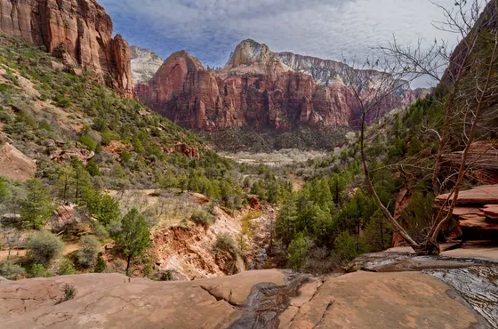
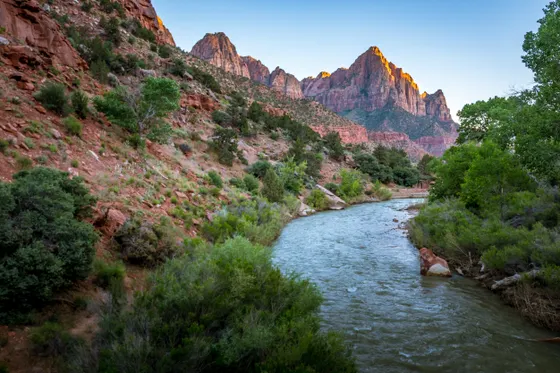
Zion National Park in southwestern Utah is a canyon carved in red, orange, and white Navajo sandstone, a vertical world where 2,000-foot cliffs tower over the Virgin River and narrow slot canyons filter sunlight into ribbons of gold. It's consistently ranked among the most dramatic landscapes in the American West, and for good reason.
The park centers on Zion Canyon, a 15-mile gorge accessible only by a free shuttle (private vehicles are banned March through November). The route below is optimized to avoid three common mistakes: the parking bottleneck at the visitor center (the lot fills by 7:30 AM), the backtrack from Springdale to the East Entrance, and the brutal "Angels Landing + Narrows on the same day" trap that leaves you rushed and exhausted. It splits the two famous hikes across two days, then exits east, putting you in position for Bryce Canyon, Page, or the Grand Canyon without a single repeated mile. If you're building a Zion and Bryce Canyon itinerary, that east-exit routing is the piece most plans miss: it drops you about 1.5 hours from Bryce with zero backtracking.
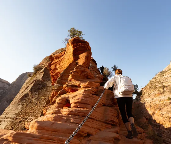
The most iconic hike is Angels Landing: a 5.4-mile round-trip trail that ascends 1,488 feet via steep switchbacks (Walter's Wiggles) before a half-mile chain-assisted ridge walk to a narrow rock fin above the canyon. A permit lottery is now required to access the final section. Apply at recreation.gov (permit required, ~$6 lottery fee).
Angels Landing permits open via two lotteries on recreation.gov: a seasonal lottery months ahead and a day-before lottery at noon mountain time. The fee is ~$6 regardless of outcome. Springdale lodging books months ahead for summer and fall weekends, so reserve early. Private vehicles are banned on the Zion Canyon Scenic Drive March through November, so plan around the free shuttle.

The High-Adventure Monoliths
Day 1 is about beating the heat, securing parking, and tackling Zion's famous heights while the canyon is still cool and quiet.
6:15 AM, secure parking, board the shuttle. Park at the Zion Canyon Visitor Center. If the lot is already full (it routinely fills by 7:30 AM in peak season), park in Springdale and ride the free town shuttle to the pedestrian entrance, then board the first available Zion Canyon Shuttle.
7:00 AM to 11:30 AM, Angels Landing (permit required). Take the shuttle to Stop #6 (The Grotto). Cross the footbridge to the West Rim Trail, climb through shaded Refrigerator Canyon, then up the 21 switchbacks of Walter's Wiggles to Scout Lookout. If you drew an Angels Landing permit, push up the spine-tingling 0.5-mile chain section to the summit. If you didn't draw the lottery, Scout Lookout itself delivers a knockout panoramic view with no reservation required.
11:30 AM to 1:00 PM, lunch at Zion Lodge. Shuttle one stop south to Stop #5 (Zion Lodge). Grab a burger or salad at the Castle Dome Café and sprawl under the giant cottonwood on the lawn while your legs recover.
1:00 PM to 3:30 PM, Lower & Upper Emerald Pools. Cross the road from the lodge to the Emerald Pools Trailhead. The 2.2-mile shaded round-trip passes weeping alcoves and waterfall-fed pools, a perfect low-impact cool-off after the morning's climb.
Evening. Shuttle back to Springdale. Dinner at King's Landing Bistro or Bit & Spur, then an early bedtime for tomorrow's river day.
- ~5.4 mi RT · 1,488 ft gain · hard · permit required · Stop #6 The Grotto
- Scout LookoutKnockout panoramic view · no permit required · turnaround if you miss the lottery
- Lower & Upper Emerald Pools~2.2 mi RT · shaded · weeping alcoves and waterfall-fed pools
- Lunch at Zion LodgeStop #5 · Castle Dome Café · cottonwood lawn
- Secure parking by 6:15 AM at the Zion Canyon Visitor Center. If the lot is full, park in Springdale and ride the free town shuttle to the pedestrian entrance.
- If you didn't draw the Angels Landing permit, Scout Lookout still delivers a knockout panoramic view with no reservation required.
- The Emerald Pools Trail is a shaded, low-impact cool-off after the morning climb. Cross the road from Zion Lodge to the trailhead.
The Deep Canyon & The Narrows
 Virgin RiverCourt of the Patriarchs
Day 2 stays low on the canyon floor, wading the Virgin River through a 1,000-foot slot, where the walls close to within twenty feet of each other.
7:00 AM, gear up. Stop by an outfitter in Springdale (Zion Adventure Company or Zion Outfitters) for a "Narrows Package": neoprene socks, sticky-soled canyon boots, and a sturdy wooden walking stick. Don't attempt The Narrows in running shoes, the algae-slick river rocks will eat you alive.
8:00 AM, Riverside Walk. Take the shuttle to the final stop, Stop #9 (Temple of Sinawava). Walk the paved 1-mile Riverside Walk alongside the Virgin River to the point where the pavement ends and the river itself becomes the trail.
9:00 AM to 1:30 PM, wading The Narrows (bottom-up). Step into the cold Virgin River and hike upstream into the towering slot canyon. Push for roughly two hours upriver until you reach Wall Street, the narrowest and most dramatic section, where the walls rise 1,000 feet and close to within 22 feet of each other. Turn back here and retrace your route. No permit required for this stretch.
⚠ Safety check. Before stepping into the river, confirm with the Wilderness Desk or the visitor center that there are no flash-flood warnings and no toxic-cyanobacteria advisories. Flash floods can occur on a clear day if storms hit upstream.
2:30 PM, Court of the Patriarchs. On the shuttle ride back down the canyon, hop off briefly at Stop #3 (Court of the Patriarchs) for a 5-minute walk to the viewpoint of the three massive sandstone peaks: Abraham, Isaac, and Jacob. Photograph and reboard the next shuttle, they come every few minutes.
- ~9.4 mi RT · 334 ft gain · hard · no permit · turn back at Wall Street
- Riverside WalkPaved 1 mi · Stop #9 Temple of Sinawava · to where the river becomes the trail
- Narrows Package from a Springdale outfitterZion Adventure Company or Zion Outfitters · neoprene socks, canyon boots, walking stick
- Court of the PatriarchsStop #3 · 5-minute walk · Abraham, Isaac & Jacob
- Don't attempt The Narrows in running shoes. Rent a Narrows Package (neoprene socks, sticky-soled canyon boots, wooden walking stick) from a Springdale outfitter.
- Before stepping into the river, confirm with the Wilderness Desk or visitor center that there are no flash-flood warnings or toxic-cyanobacteria advisories. Flash floods can occur on a clear day if storms hit upstream.
- On the shuttle ride back, hop off at Stop #3 for the 5-minute walk to Court of the Patriarchs, then reboard the next shuttle, they come every few minutes.
The East Rim Highway & Exit Route
Day 3 turns the trip into a seamless eastward transition toward your next destination, with zero backtracking.
8:00 AM, check out, drive east. Pack the car and leave Springdale on Highway 9 (Zion–Mount Carmel Highway), ascending the spectacular series of switchbacks that climb out of the canyon's main basin.
8:30 AM, the Zion–Mount Carmel Tunnel. Drive through the historic 1.1-mile tunnel blasted into solid sandstone in 1930. Keep an eye out for the cut-out "windows" that offer brief glimpses down into the canyon below.
9:00 AM to 10:30 AM, Canyon Overlook Trail. Immediately after exiting the tunnel, look for the small parking areas on the right and left. The 1-mile out-and-back hugs a cliff edge, crosses a wooden boardwalk bridge, and ends at a sheer drop directly over Zion Canyon. The reward-to-effort ratio rivals Angels Landing.
11:00 AM, Checkerboard Mesa. Continue east another 10 to 15 minutes to the Checkerboard Mesa pullout, a massive white-and-red sandstone hill weathered into a grid of horizontal and vertical cracks.
11:30 AM, onward. From here you're perfectly positioned for the next leg: Bryce Canyon National Park (under 2 hours northeast on UT-9/US-89), Page, AZ + Horseshoe Bend / Antelope Canyon (~2 hours east), or the Grand Canyon North Rim (~3 hours southeast).
- ~1 mi out-and-back · cliff edge & boardwalk · sheer drop over Zion Canyon
- Zion–Mount Carmel Highway & TunnelHighway 9 switchbacks · historic 1.1-mile 1930 tunnel with cut-out windows
- Checkerboard MesaPullout 10 to 15 min east · sandstone hill weathered into a grid of cracks
- Onward: Bryce, Page or Grand Canyon North RimBryce <2 hr · Page ~2 hr · Grand Canyon North Rim ~3 hr
- Leave Springdale on Highway 9 and climb the switchbacks out of the canyon, then drive the historic 1.1-mile Zion–Mount Carmel Tunnel, watching for the cut-out windows over the canyon.
- Park at the small lots just east of the tunnel for the Canyon Overlook Trail, a 1-mile out-and-back whose reward-to-effort ratio rivals Angels Landing.
- Exiting east leaves you positioned for Bryce Canyon (under 2 hours), Page and Horseshoe Bend (~2 hours), or the Grand Canyon North Rim (~3 hours) with no repeated mile.
Mount Carmel HighwayCheckerboard MesaNow build your Zion trip.
You've seen all three days. Open the free drag-and-drop planner and tune it for your dates, your pace, and whether you base in Springdale or push east toward Bryce, Page, or the Grand Canyon.
What we actually learned in the canyon.
America the Beautiful Pass
If you're visiting two or more national parks on this trip, the $80 annual pass pays for itself at the gate after Zion plus one more.
Hydration
The desert dries you out faster than you expect. Carry 2 to 3 liters of water per person, even on cooler days.
Shuttle strategy
Private vehicles are banned on the Zion Canyon Scenic Drive from March through November. The free shuttle runs every few minutes starting around 6 AM, so embrace it.
Permit lottery
Angels Landing permits open via two lotteries on recreation.gov, a seasonal lottery (months ahead) and a day-before lottery (noon MT, day before you hike). The fee is ~$6 regardless of outcome.
Read the flash-flood rating every morning
The Narrows and Zion's slot canyons carry a real, sometimes fatal flash-flood risk, since rain falling miles upstream can send a wall of muddy water through a canyon with nowhere to climb out. Check the day's flash-flood rating posted at the visitor center before you go, and never enter a narrows or deep wash when it reads Potential or Expected.
Everything you'll actually want to know.
Ready to go? Get your
Zion hiking route.
Trailheads and mileages, the shuttle stops, the Angels Landing permit lottery, Narrows gear, drive times from Las Vegas and Salt Lake City, and the day-by-day timing you need to hike Zion without the same-day burnout trap.
Instant book · Free cancellation · Secure payment via Stripe
Know these trails yourself? Become a local guide and host free community hikes.


Planning this trip?
Save it, share it with your crew, or find travelers heading the same way.
What other travelers are saying
Be the first to leave a tip or question for the next traveler.
How was your experience?
Tell us what worked and what did not. It goes straight to Yulia and Margarita.