
Mount Whitney Trail:
A Summit Hiking Itinerary
A 2 to 3 day plan for hiking Mount Whitney on the Mount Whitney Trail: acclimatize near Lone Pine, then climb the ~22-mile round trip past the 99 switchbacks and Trail Crest to the 14,505-foot summit.
Free interactive planner · drag & reorder your days, add stops, map it in minutes
Build your own Mount Whitney trip, drag, reorder & map it.
Drag stops between days, add acclimatization hikes near Lone Pine and Bishop, and plan your camps with the place search. The live map and times recalculate as you go, and we'll flag a summit day that is too long to be safe at altitude.
Opens a side panel · reorder days, add custom stops, see your route live
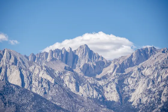
One trail, the highest summit in the lower 48.
Mount Whitney rises to 14,505 feet, the highest peak in the contiguous United States, on the crest of the Eastern Sierra above the town of Lone Pine, California. The Mount Whitney Trail from Whitney Portal is the standard, non-technical route in summer: roughly 22 miles round trip with about 6,100 feet of gain, the famous 99 switchbacks, and Trail Crest before the final push to the summit.
This is a serious undertaking. Most hikers do it as one very long day hike or split it into a 2-day overnight, camping at Outpost Camp (about 3.8 miles in) or Trail Camp (about 6 miles in). A permit is required for both day hikes and overnights, awarded through the Mount Whitney Lottery on recreation.gov, with the main application window from February to mid-March. The lottery is very competitive, so plan your dates around the permit, not the other way around.
The best window is July through September. Outside summer the trail holds snow and ice and becomes a mountaineering route requiring an ice axe, crampons, and the skills to use them. Altitude is the number one danger, so acclimatize in Lone Pine or Bishop first, start before dawn with an alpine start to beat afternoon thunderstorms, carry a bear canister, and remember campfires are not allowed.
A permit is required to hike the Mount Whitney Trail, day hike or overnight, and it is awarded through the Mount Whitney Lottery on recreation.gov. Apply during the main window from February to mid-March. Demand far exceeds supply, especially for weekends, so be flexible on dates and consider weekday or shoulder-season entries. Lodging in Lone Pine and Bishop also fills fast in summer, so book once you have a permit.
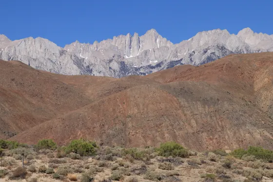
Arrive in Lone Pine & acclimatize
Get to the Eastern Sierra and give your body time at altitude before you climb. Lone Pine, California sits at about 3,700 feet, and it is the classic base for the Mount Whitney Trail. From here it is roughly 3.5 to 4 hours from Reno (RNO) or Las Vegas (LAS), or a shorter drive from Mammoth Yosemite (MMH). Pick up your permit details, top off food and fuel, and rent or buy a bear canister if you do not have one.
The single best thing you can do today is gain elevation gently and sleep high. Drive up to Whitney Portal (8,360 ft) to scout the trailhead, walk the Whitney Portal to Lone Pine Lake stretch as an easy acclimatization leg, or head north to Bishop for higher trailheads. Eat well, hydrate hard, and turn in early: tomorrow starts in the dark.
- Drive to Lone Pine, CAReno or Las Vegas ~3.5 to 4 hr · Mammoth (MMH) closer · base town at ~3,700 ft
- Acclimatization hike near Whitney PortalWalk toward Lone Pine Lake · gain elevation gently · sleep high
- Permit required · bear canister required · no campfires
- Stay in Lone Pine (or Bishop)Sleep as high as you comfortably can the night before · book ahead in summer
- Altitude sickness is the number one reason people fail to summit Whitney. Spend a night or two in Lone Pine or Bishop and do a high acclimatization hike before your climb.
- A bear canister is required to store food on the Mount Whitney Trail, and campfires are not allowed anywhere on the route. Rent or buy a canister in town if you need one.
- Lodging in Lone Pine and Bishop fills fast in summer. Book your room as soon as you secure a permit through the Mount Whitney Lottery.
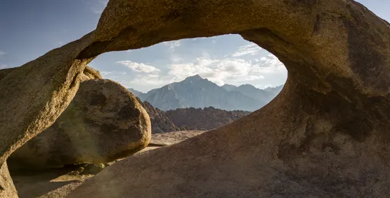
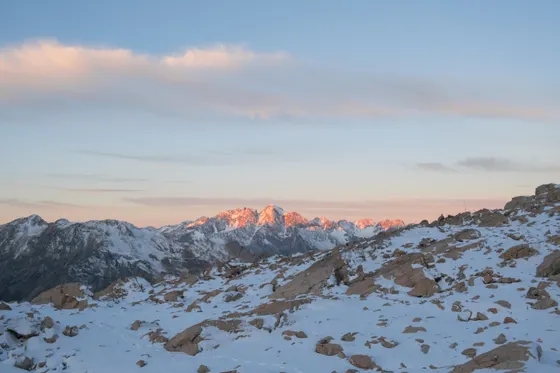
The climb · Whitney Portal, the 99 switchbacks & the summit
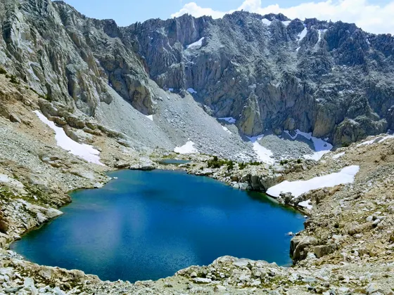
Whitney summit Trail Crest
This is summit day. Begin with an alpine start well before dawn from Whitney Portal (8,360 ft) to put time in the bank and be off the high ridges before afternoon thunderstorms build. The trail climbs steadily past Lone Pine Lake, Mirror Lake, and Trailside Meadow up to Trail Camp (about 6 miles, ~12,000 ft), the last reliable water and the staging point for the big climb.
Above Trail Camp come the legendary 99 switchbacks, a relentless set of turns climbing to Trail Crest at about 13,600 feet, where you cross into Sequoia National Park and the John Muir Trail junction. From there the rocky traverse leads to the 14,505-foot summit and its stone shelter hut. Soak it in, then turn around with plenty of daylight: the descent of the full ~22-mile round trip is long, and most of the day's risk is on the way down when you are tired.
- Start well before dawn · 8,360 ft trailhead · beat the afternoon storms
- Trail Camp · last reliable water~6 mi · ~12,000 ft · filter water here before the switchbacks
- The 99 switchbacks to Trail CrestRelentless turns to ~13,600 ft · into Sequoia NP · pace yourself
- Mount Whitney summit14,505 ft · highest in the lower 48 · turn around with daylight to spare
- Start your alpine start hours before sunrise. Afternoon thunderstorms are common in the high Sierra, and you want to be off Trail Crest and the summit before they build.
- Trail Camp at about 12,000 feet is the last reliable water source. Filter and carry what you need before you start the 99 switchbacks, as there is no water above it.
- Most accidents happen on the descent when hikers are tired. Pace yourself, eat and drink steadily, and turn around by a set time even if you have not reached the summit.
Overnight option, recovery & getting home
If you split the climb into a 2-day overnight rather than one big day, this is where it pays off. With an overnight permit you camp partway up, most commonly at Outpost Camp (about 3.8 miles in) or Trail Camp (about 6 miles in), summit on a fresh pair of legs the next morning, and walk the rest of the way out. Splitting the elevation also gives your body more time to adjust, which helps with altitude on the highest peak in the lower 48.
Whether you went car-to-car or camped high, plan a recovery morning before the long drive home. Refuel in Lone Pine, soak in the views of the Sierra crest you just stood on, and consider a relaxed Eastern Sierra detour like the Alabama Hills. Getting home: it is roughly 3.5 to 4 hours back to Reno (RNO) or Las Vegas (LAS), or a shorter run to Mammoth Yosemite (MMH), so start with daylight and a full tank.
- Outpost Camp ~3.8 mi or Trail Camp ~6 mi · overnight permit · bear canister required
- Recover in Lone Pine & the Alabama HillsRefuel, rest, and take in the Sierra crest before the drive out
- Getting home: Reno, Las Vegas or MammothRNO or LAS ~3.5 to 4 hr · MMH closer · fuel up and leave with daylight
- An overnight permit lets you camp at Outpost Camp or Trail Camp and summit fresh the next morning, and the extra night high helps your body acclimatize.
- You must pack out everything, including human waste using the provided WAG bags. Campfires are not allowed and a bear canister is required for all food and scented items.
- After the climb, give yourself a slow recovery morning. It is a long, high-desert drive back to Reno, Las Vegas, or Mammoth, so refuel and leave with plenty of daylight.
Now build your Mount Whitney trip.
You've seen the whole plan. Open the free drag-and-drop planner and tune it for your dates, your fitness, your permit, and whether you push it as a single big day or split it over a Trail Camp overnight.
What we actually learned on the mountain.
You need a permit, and it is competitive
A permit is required for the Mount Whitney Trail, day hike or overnight. It is awarded through the Mount Whitney Lottery on recreation.gov, with the main application window from February to mid-March. Demand far exceeds supply, so be flexible on dates and apply for weekdays and shoulder-season entries to improve your odds.
Acclimatize before you climb
Altitude sickness is the number one reason hikers fail or get hurt on Whitney. Spend a night or two in Lone Pine or Bishop and do a high acclimatization hike beforehand. Ascend gradually, hydrate, and know the warning signs of altitude illness so you can turn around if needed.
Start before dawn, finish before storms
Make an alpine start hours before sunrise so you summit by midday and descend before afternoon thunderstorms build over the crest. Lightning on the exposed summit ridge and Trail Crest is a real danger in summer. Turn around by a set time even if the summit is close.
Carry water and filter at Trail Camp
Trail Camp at about 12,000 feet is the last reliable water on the route. Filter and carry everything you need before the 99 switchbacks. Drink steadily all day, because dehydration at altitude makes altitude sickness worse.
Bear canister required, no campfires
A bear canister is required to store all food and scented items on the Mount Whitney Trail, and campfires are not allowed anywhere on the route. Pack out all trash and use the provided WAG bags for human waste. Rent or buy a canister in Lone Pine or Bishop.
Go July through September
Summer is the only window the trail is a non-technical hike. Outside roughly July to September it holds snow and ice and becomes a mountaineering route requiring an ice axe, crampons, and the skills to use them. Check current conditions with the Inyo National Forest before you go.
Everything you'll actually want to know.
Ready to go? Get your
Mount Whitney summit plan.
The permit and lottery timing, acclimatization plan, alpine-start logistics, the 99 switchbacks and Trail Crest, where to camp overnight, and drive times from Reno, Las Vegas, and Mammoth to climb Whitney safely.
Instant book · Free cancellation · Secure payment via Stripe
Know these trails yourself? Become a local guide and host free community hikes.

Planning this trip?
Save it, share it with your crew, or find travelers heading the same way.
What other travelers are saying
Be the first to leave a tip or question for the next traveler.
How was your experience?
Tell us what worked and what did not. It goes straight to Yulia and Margarita.