The Most-Hiked Trail in Washington State
Rattlesnake Ledge pulls somewhere around 100,000 visitors per year, making it one of the most-used trails in the entire Pacific Northwest. And it earns the traffic. The 4-mile round trip delivers 1,160 feet of gain and ends at a broad rocky ledge with one of the best views accessible to hikers of any fitness level near Seattle: Rattlesnake Lake directly below, Cedar River Watershed spreading south, and the Cascade peaks from the Snoqualmie Pass corridor to the north. On a clear day Mount Rainier appears to the south.
The popularity is a double-edged sword. On a summer Saturday, the trailhead parking lot fills by 8am and overflows onto SE 158th Street for a quarter-mile. The trail itself will have hundreds of hikers. The ledge can feel crowded. But the trail is also completely hiked 365 days a year, the King County trail crew keeps it passable through winter, and hiking it in January with no crowds and fresh snow on the peaks is an entirely different and quieter experience.
Trail Stats
- Distance: 4 miles round trip to Rattlesnake Ledge
- Elevation gain: 1,160 feet
- Difficulty: Moderate
- Best season: Year-round, snow possible November–March, microspikes may be needed
- Permit: Discover Pass required for parking ($30/year or $11.50/day)
- Time: 2–3.5 hours round trip
Getting There
The Rattlesnake Ledge trailhead is at the Rattlesnake Lake Recreation Area, 3 miles south of North Bend, WA on Cedar Falls Road SE. From Seattle: I-90 east to exit 32 (436th Ave SE), south on 436th, right onto SE North Bend Way, left onto Cedar Falls Road SE. GPS: 47.4329° N, 121.7697° W. The drive is about 30–35 minutes from downtown Seattle.
Parking is in a large lot at Rattlesnake Lake. Despite the lot's size, it fills on weekends. Arrive by 8am on summer Saturdays or expect to park along the road. A Discover Pass is required, there are iron rangers at the trailhead. A new parking reservation system has been piloted for peak periods; check the King County Parks website for current requirements.
The Route
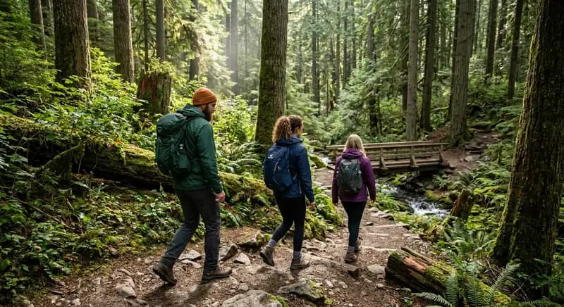
Trailhead to Rattlesnake Ledge (2 miles, ~1,160 feet gain): The trail starts from the parking lot on the north side of Rattlesnake Lake. The first 0.25 miles is flat boardwalk through wetland habitat. Then the climbing starts, well-graded switchbacks through second-growth Douglas fir and alder. The trail surface is packed dirt and rock, well-maintained and wide enough for two hikers abreast in most sections.
The gain is consistent, there's no flat section to recover in the middle. But the switchbacks are reasonable and the trail is never technical. At mile 1.5, the forest opens briefly and you get your first views east toward the Cascades. The final 0.5-mile steepens before the trees give way and you step onto the ledge.
At Rattlesnake Ledge: The main ledge is a broad slab of rock that slopes gently toward the view, Rattlesnake Lake 1,000 feet below, Cedar River Watershed and its reservoir, and the Cascade range filling the horizon. The ledge has enough room for 50+ people comfortably. On busy days it has 200.
Above the main ledge, a rough climber's trail continues up the ridge for 0.5–1 mile to additional ledges with fewer people and better views north toward Snoqualmie Valley. This upper ridge is worth doing if you want solitude and more elevation, but the trail is informal and involves some scrambling.
Crowds and How to Avoid Them
This is not an exaggeration: on a summer Saturday, you will encounter hundreds of hikers. Dogs, children, strollers (not recommended but attempted), people in jeans and Uggs, everyone hikes Rattlesnake Ledge. This is not a criticism; it's what happens when a beautiful trail is accessible near a major city. But if you want a quieter experience:
- Weekdays: Dramatically fewer people. Parking is easy. The ledge has breathing room.
- Early morning: On summer weekends, arriving by 7am means you'll be at the ledge with a dozen people rather than 200.
- Winter: November through February on a weekday is almost solitary hiking. Bring microspikes, the trail ices over and becomes a slip hazard without traction.
- Rain: Crowds drop by 80% in steady rain. The trail is wet but the views are often dramatic with low clouds.
Dogs at Rattlesnake Ledge
Dogs are allowed and extremely common. The trail has water sources along the way (the creek that drains from the ledge area). Bring a collapsible bowl, your dog will need it. Leash your dog on the trail (required) and near the ledge edge, which is an abrupt drop. Dog waste bags and a pack-it-out ethic are essential, this trail sees enough traffic that waste accumulation is a real problem.
Year-Round Conditions
Summer (June–September): Trail is dry, warm, and busy. Views are consistently good. Wildflowers on the ledge in June.
Fall (October–November): Crowds thin, foliage colors appear on the slopes below, views improve on clear days. Best combination of weather and solitude.
Winter (December–February): Snow and ice on the upper trail. Microspikes are essential when frozen, the switchbacks become genuinely dangerous without traction. Beautiful with snow on the peaks. Bring layers.
Spring (March–May): Mud season. The trail can be muddy and slippery through April. Stay on trail to avoid widening damage. Wildflowers start appearing in May.
What to Bring
For a 2–3 hour moderate hike: 1.5–2 liters of water (no reliable water source on trail), a snack for the ledge, layers (the ledge is exposed and wind can be cold), and trekking poles if you're not comfortable on steep terrain (helpful for the descent on slippery days). Microspikes from November through March when icy. Discover Pass for parking.
Extending the Hike: Rattlesnake Mountain
If Rattlesnake Ledge isn't enough, the ridge trail continues 3.5 miles from the main ledge to the East Peak of Rattlesnake Mountain (3,517 feet). This extension adds 1,400 feet of gain, dramatically fewer people, and views that extend to Mount Rainier, the Olympics, and Puget Sound on clear days. The East Peak trail is unsigned and follows the ridge, it's less maintained but not difficult to follow.