Oregon Coast Trail:
A 5-Day Itinerary
Five days sampling the best of the Oregon Coast Trail along the scenic north coast: Cannon Beach and Haystack Rock, Oswald West, Cape Lookout, Cape Kiwanda, and the tidepools and cliffs of Cape Perpetua.
Free interactive planner · drag & reorder your days, add stops, map it in minutes
Build your own Oregon Coast Trail trip, drag, reorder & map it.
Drag stops between days, swap a beach walk for a headland trail, and add your own viewpoints and tidepools with the place search. The live map and drive times recalculate as you go, and we will flag the spots where you need to time the tide to round a headland.
Opens a side panel · reorder days, add custom stops, see your route live
One coast, beaches, headlands & tidepools, all along Highway 101.
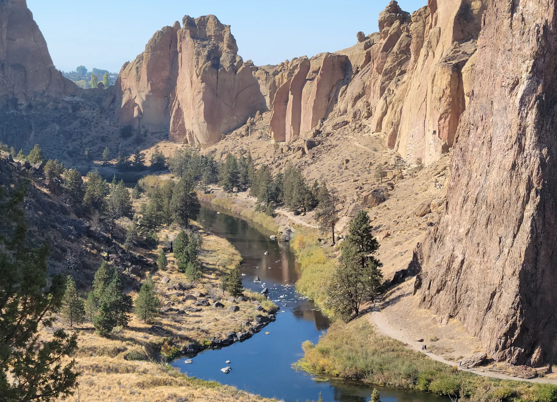
The Oregon Coast Trail runs about 362 miles down the entire Oregon coast, from the Columbia River at Fort Stevens to the California border. It is not one continuous tread: it strings together long beach walks, forested headland trails, and stretches of road walking, with a handful of river mouths that you cross by short boat or seasonal ferry. Almost nobody hikes the whole thing at once, so most people walk sections.
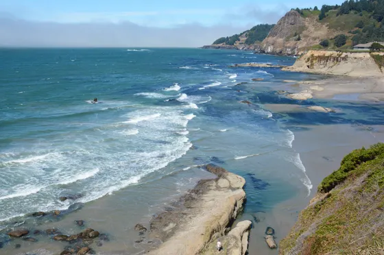
This 5-day route samples the most scenic stretch, the north coast, as a day-by-day driving and hiking trip. You will walk past Haystack Rock at Cannon Beach, hike Ecola State Park and Oswald West, trace the old-growth cape trail at Cape Lookout, scramble the dunes at Cape Kiwanda, and finish at Cape Perpetua over Thor's Well, Devils Churn, and the tidepools below Heceta Head.
June through September is the driest, warmest window, though it can still be cool, gray, and windy. Spring and fall are quieter and often beautiful between storms. Whatever the season, the single most important thing on the OCT is the tide: several headlands can only be rounded at low tide, so check a tide table before every beach section.
Coastal towns like Cannon Beach, Pacific City, and Yachats fill up fast on summer weekends, so book lodging early. Oregon State Parks run popular hiker/biker camps and campgrounds along the route that reserve out months ahead in peak season. Most important of all, carry a tide table: a few headlands on the OCT can only be passed safely near low tide.

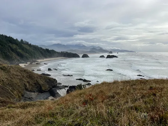

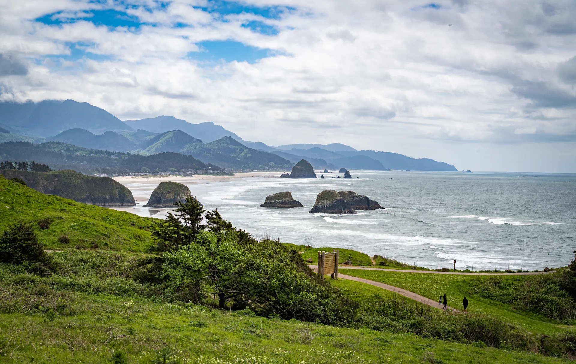
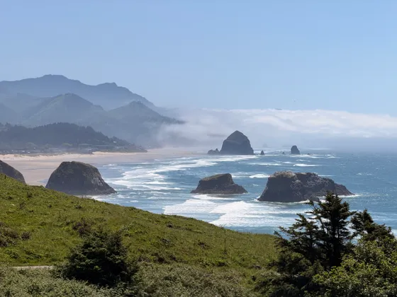
Cannon Beach · Ecola State Park & Haystack Rock
Start on the north coast at Cannon Beach, about 1.5 hours from Portland (PDX). The town fronts a long, wide beach anchored by Haystack Rock, a 235-foot sea stack ringed by tidepools and a protected seabird colony, including puffins in early summer. Walk the sand at low tide to see the anemones and sea stars in the rocky garden at its base.
Just north, Ecola State Park packs in the OCT's most famous viewpoints: forested headland trails, the overlook to Tillamook Rock Lighthouse out at sea, and the cove at Indian Beach. The state park trail between Ecola Point and Indian Beach is a classic taste of the Oregon Coast Trail through coastal forest above the surf. Check the tide before you walk any beach section here.
- Headland viewpoints, Indian Beach & the OCT through coastal forest
- 235-ft sea stack · low-tide tidepools · puffins in early summer
- Cannon Beach town & beachWide sand, galleries & sea stacks · easy walking base
- Stay in Cannon BeachWalkable coastal town · books up fast on summer weekends
- Haystack Rock's tidepools are only exposed at low tide. Check a tide table and aim for the hour or two around the lowest water to see the sea stars and anemones.
- Do not climb on Haystack Rock or disturb the nesting seabirds. Volunteers from the Haystack Rock Awareness Program are often there to point out puffins and tidepool life.
- Cannon Beach is a small, popular town. Book lodging well ahead for summer weekends, or base a little south in Tillamook to save money.

Oswald West State Park · Cape Falcon & Short Sand Beach
Drive a short way south to Oswald West State Park, one of the most loved stretches of the whole Oregon Coast Trail. A forest trail drops through old-growth Sitka spruce to Short Sand Beach, a cove tucked in a rocky amphitheater that is a magnet for surfers and a perfect spot to watch the swell roll in.
From the cove, hike the OCT out to Cape Falcon (about 5 miles round trip, moderate), a long forested headland that ends in a grassy point with sweeping views back over Smuggler Cove and Neahkahnie Mountain. For a bigger day, the trail up Neahkahnie Mountain climbs to one of the highest coastal viewpoints in the state. Both are sections of the Oregon Coast Trail.
- ~5 mi RT · moderate · forested headland to a grassy point
- Cove through old-growth · surfers · classic OCT walk-in
- Neahkahnie MountainOptional climb to one of the highest coastal viewpoints in Oregon
- Second night in Cannon BeachStay put · Oswald West is a short drive south
- Short Sand Beach is a walk-in only, reached by a short forest trail from the highway lot. The lot fills on summer weekends, so arrive early.
- Cape Falcon's final point is brushy and can be muddy. Wear shoes you do not mind getting wet and watch your footing near the edge.
- Oswald West has no campground of its own anymore, so plan to camp or lodge in Cannon Beach, Manzanita, or one of the nearby state park camps.
Cape Lookout · old-growth to a headland over the sea
Head south past Tillamook to Cape Lookout State Park and one of the signature hikes of the Oregon Coast Trail. The Cape Trail (about 4.7 miles round trip, moderate) runs out along a narrow forested headland of old-growth spruce and hemlock to a tip that juts more than two miles into the Pacific, hundreds of feet above the surf. In spring it is one of the best whale-watching perches on the coast.
The state park also has a long sand spit, a campground right behind the dunes, and beach access for an easy evening walk. This is the heart of the Three Capes scenic stretch, so settle into Pacific City or a nearby state park camp for the night and slow down with the pace of the coast.
- ~4.7 mi RT · moderate · old-growth headland 2 mi into the sea
- Whale watching from the capeSpring and winter migrations pass close below the point
- Cape Lookout sand spit & beachLong spit and dune-backed beach for an easy evening walk
- Stay in Pacific CityThree Capes base · or camp at Cape Lookout State Park
- The Cape Trail is often muddy and root-tangled even in summer, thanks to the coastal forest. Sturdy shoes and a little patience make it much more enjoyable.
- Three trails leave the same trailhead. Follow signs for the Cape Trail (straight out to the point), not the North or South Trails, unless you want a steeper descent to the beach.
- Cape Lookout State Park campground sits right behind the dunes and reserves out far ahead for summer. Book early through Oregon State Parks or base in Pacific City.
Cape Kiwanda & Pacific City · the Three Capes finale
Spend the morning at Cape Kiwanda in Pacific City, a stubby sandstone headland streaked orange and gold, fronted by a giant dune and its own offshore Haystack Rock. Climb the steep sand dune for the classic view down the cape, watch the dory boats launch straight off the beach, and explore the wind-carved sandstone, staying well back from the unfenced edges and sneaker waves.
This is the southern end of the Three Capes route, which links Cape Meares, Cape Lookout, and Cape Kiwanda. From Pacific City it is an easy beach walk and a relaxed afternoon, then a drive south down Highway 101 toward Yachats to set up for the dramatic Cape Perpetua coast tomorrow. Watch the tide on any beach sections along the way.
- Sandstone headland, giant dune climb & offshore sea stack
- Pacific City dory boatsWatch the dory fleet launch straight off the beach
- Pacific City beach walkEasy sand walking · stay back from the unfenced cape edge
- Drive south & stay in Yachats~2 hr down Highway 101 · gateway to Cape Perpetua
- Cape Kiwanda's sandstone is unfenced and crumbling, and sneaker waves have swept people off the rocks. Stay well back from the edge and never turn your back on the ocean.
- The dune climb is short but steep and tiring in soft sand. Go early before the wind and crowds, and bring water.
- It is about a 2-hour drive from Pacific City down to Yachats. Break it up with a stop in Newport if you want lunch and the bayfront.
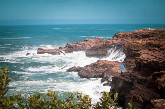
Cape Perpetua · Thor's Well, Devils Churn & Heceta Head
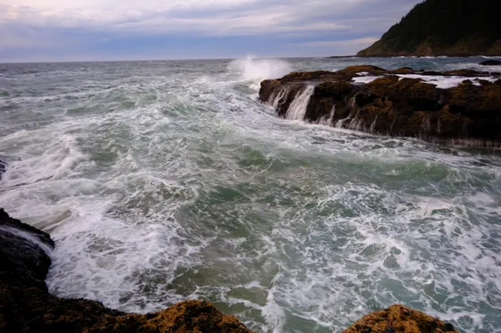
Finish at the most dramatic stretch on the route, the Cape Perpetua Scenic Area just south of Yachats. The Captain Cook Trail leads down to the rocky shore and the basalt show: Thor's Well, a sinkhole that appears to swallow the sea, the Spouting Horn, and Devils Churn, a narrow chasm where waves explode. These features are best near high tide on a day with good swell, but the rocks are slippery and dangerous, so watch from a safe distance.
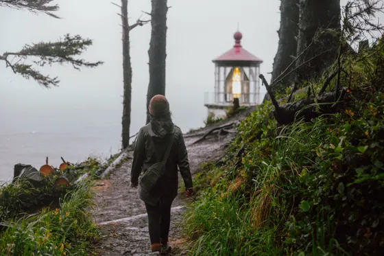
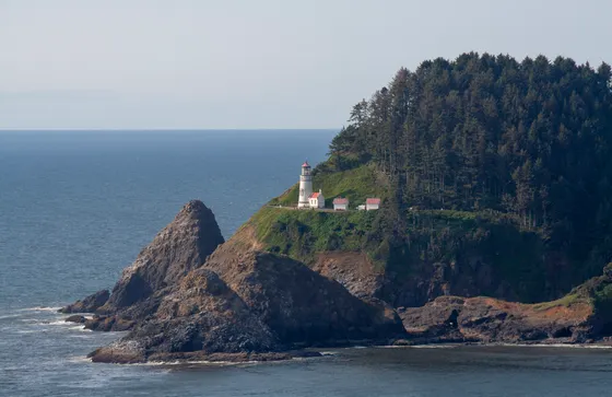
For the view, drive or hike to the Cape Perpetua overlook, the highest viewpoint you can reach on the Oregon coast. Then end the trip a few miles south at the Heceta Head Lighthouse area, with its picture-perfect lighthouse on a headland and tidepools below. Getting home: from Yachats it is roughly 3.5 hours back to Portland (PDX), so leave with daylight to spare.
- Sinkhole, Spouting Horn & tidepools · best near high tide · stay back
- Devils ChurnNarrow basalt chasm where waves explode · slippery rocks
- Cape Perpetua overlookHighest viewpoint on the Oregon coast · drive or hike up
- Heceta Head LighthouseIconic lighthouse headland & tidepools a few miles south
- Getting home: Portland (PDX)~3.5 hr from Yachats · leave with daylight to spare
- Thor's Well, the Spouting Horn, and Devils Churn put on the best show near high tide with a decent swell, but that is exactly when the rocks are most dangerous. Keep your distance and never turn your back on the ocean.
- For Thor's Well photos, get there as the tide rises and use a long lens from the higher rocks rather than walking out close to the well.
- Heceta Head Lighthouse is a short walk from the Devil's Elbow lot. Time the tidepools below for low tide, then start the roughly 3.5-hour drive back to Portland with daylight to spare.
Now build your Oregon Coast Trail trip.
You have seen all five days. Open the free drag-and-drop planner and tune it for your dates, your pace, and whether you base in Cannon Beach, Pacific City, Yachats, or Newport.
What we actually learned on the coast.
Carry a tide table, always
The single most important tool on the Oregon Coast Trail is a tide table. Several headlands can only be rounded safely near low tide, and tidepools are only exposed at low water. Check the tide before every beach section and plan your timing around it.
Respect sneaker waves & cliff edges
The Oregon coast is beautiful and dangerous. Sneaker waves arrive without warning and have swept people off rocks and logs. Never turn your back on the ocean, stay well back from unfenced cape edges like Cape Kiwanda, and keep your distance from Thor's Well and Devils Churn.
The OCT is not one continuous trail
The route stitches together beach walks, forested headland trails, and stretches of road walking, with a few river mouths crossed by short boat or seasonal ferry. This 5-day plan drives between sections, so you hike the best headlands and beaches without the logistics of a full thru-hike.
Book state park camps early
Oregon State Parks run popular campgrounds and hiker/biker camps all along the coast, and the best ones, like Cape Lookout, reserve out months ahead for summer. Book early through Oregon State Parks, or base in coastal towns and drive to the trailheads.
Summer is driest, but pack layers
June through September is the driest and warmest window, though the coast can still be cool, gray, foggy, and windy any day of the year. Spring and fall are quieter and often lovely between storms. Bring rain and wind layers no matter the season.
Drive Highway 101 unhurried
Highway 101 ties the whole route together, winding past viewpoints, state parks, and beach pullouts. It is slow, scenic two-lane road, so build in extra time, watch for cyclists and pedestrians, and stop often. The driving is half the trip.
Everything you'll actually want to know.
Ready to go? Get your
Oregon Coast Trail route.
Trailheads and mileages, the best coastal town bases, tide-timing notes for the headlands, state park camps, and drive times from Portland so you can hike the north coast safely.
Instant book · Free cancellation · Secure payment via Stripe


Planning this trip?
Save it, share it with your crew, or find travelers heading the same way.

Liked this itinerary?
What other travelers are saying
Be the first to leave a tip or question for the next traveler.