What Is a 14er and Why Do People Hike Them?
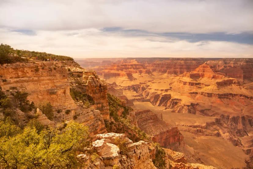
A '14er' is any peak that rises above 14,000 feet above sea level. Colorado has 58 of them, more than any other state, and they represent some of the most accessible high-altitude summit hiking in North America. Unlike the technical alpine routes of the Pacific Northwest or the remote wilderness of Alaska, most Colorado 14ers can be hiked on maintained trails with nothing more than solid fitness, proper gear, and early starts. The appeal is the summit itself: at 14,000 feet, you're above the treeline, above most clouds on clear days, and looking out across a landscape so vast it changes how you think about scale.
The Colorado Fourteeners Initiative (CFI) maintains most of the standard routes, and peak-bagging, working through the list of 58, is a legitimate hobby with its own community, apps, and culture. But you don't need to be a peak-bagger to benefit from this guide. If you want to summit one 14er as a life experience, or if you're planning a Colorado trip and want the highest achievable objective, this is where to start.
The Non-Negotiable Rules Before You Start
Every year, people die on Colorado 14ers. Most deaths are from lightning. A predictable pattern: hikers start late, reach the summit around noon, and get caught by the afternoon thunderstorm that forms almost daily in Colorado during July and August. The rule is simple and must be followed without exception: be off any exposed summit ridge by noon. Most experienced 14er hikers start before sunrise, 3 to 5 a.m. for longer routes, 5 to 6 a.m. for shorter ones. This is not optional drama; it is how you don't die.
Altitude sickness is the second hazard. At 14,000 feet, there is roughly 40% less oxygen per breath than at sea level. Symptoms of Acute Mountain Sickness (AMS) include headache, nausea, dizziness, and fatigue, common and manageable. High-Altitude Pulmonary Edema (HAPE) and High-Altitude Cerebral Edema (HACE) are rare but life-threatening. The primary prevention is acclimatization: spend at least one night above 8,000 feet before attempting a 14er. Arriving in Denver (5,280 ft) and driving to a trailhead at 10,000 feet the same day is how people end up turning around at 12,000 feet vomiting.
Best Beginner 14ers in Colorado
Not all 14ers are equal. The Colorado Fourteeners Initiative rates routes by class: Class 1 is a maintained trail, Class 2 is off-trail but non-technical, Class 3 involves scrambling, Class 4 requires using hands extensively, and Class 5 is technical rock climbing. Start with Class 1 or easy Class 2 peaks.
Mount Bierstadt (14,060 ft), Class 2, 7 miles round-trip, 2,850 ft gain
Bierstadt is consistently rated the best beginner 14er in Colorado. The trailhead at Guanella Pass sits at 11,669 feet, a head start that makes the gain more manageable. The standard route climbs through a broad, open bowl above the pass, navigating willows on the lower slopes before breaking onto rocky terrain above. The summit ridge is straightforward, the views are excellent, and the round-trip is achievable for most fit hikers in 4-6 hours. The parking lot at Guanella Pass fills by 7 a.m. on summer weekends, a 5 a.m. start is ideal.
Quandary Peak (14,265 ft), Class 1, 6.75 miles round-trip, 3,300 ft gain
Quandary has the most-used trailhead of any 14er in Colorado because it's genuinely accessible and close to Breckenridge. The East Ridge Trail is pure Class 1: a maintained path the entire way, no route-finding, no scrambling. It climbs through forest, breaks out onto a broad ridge above treeline, and follows the ridge to the summit plateau. The consistent grade and clear trail make it ideal for first-timers. It's also extremely popular, arrive before 6 a.m. on weekends to avoid the 200-car parking problem.
Grays Peak and Torreys Peak (14,270 ft / 14,267 ft), Class 1, 8 miles round-trip for both, 3,000 ft gain
Grays and Torreys are often done together because the col between them is only 500 feet below each summit. The trailhead at 11,280 feet gives a reasonable start elevation. The Grays Peak trail is Class 1 the whole way; a side trail from the col reaches Torreys. Bagging two 14ers in a single day is more satisfying than it sounds, and the high ridge between them provides genuinely spectacular views of the Front Range and the Continental Divide.
Mount Sherman (14,036 ft), Class 1-2, 5.7 miles round-trip, 2,000 ft gain
Sherman is one of the shortest and lowest-gain 14ers in Colorado, and the old mining roads that lace the approach make for a relatively gentle climb. Located in the Mosquito Range near Fairplay, it's less dramatic than the Front Range peaks but very achievable and extremely reliable. Good choice when you're still calibrating your acclimatization.
Training for High Altitude
The fitness requirement for a Class 1 or easy Class 2 14er is honest cardiovascular endurance, not mountaineering skill. Think of it as a very long, steep day hike. If you can comfortably hike 10 miles with 2,500 feet of gain at sea level, you can likely summit a moderate 14er once acclimatized. The altitude is the X-factor that training at home can't fully replicate, you can improve your aerobic base significantly, but you'll still need days at elevation to adjust your blood oxygen carrying capacity.
A 6-week training plan that works: three days per week of hiking or stair-climbing (30-60 minutes), weekly long hike increasing from 6 miles to 10+ miles, and one day of elevation-specific training (steep stairs with a loaded pack). The goal is building the muscular endurance in your quads and calves for sustained climbing, and the aerobic capacity to sustain effort at reduced oxygen partial pressure. If you live at low elevation, consider adding Elevate or similar altitude simulation supplements, some studies show modest benefit, though none can fully replicate the physiological changes of actual altitude exposure.
Gear Checklist for a 14er Day Hike
The gear list for a standard Class 1 or 2 14er is not complicated, but every item matters:
- Footwear: Trail runners or light hiking boots with good ankle support and aggressive grip. The rocky terrain above treeline punishes soft-soled shoes.
- Layers: Start in a light base layer. Carry a fleece mid-layer and a waterproof hard shell. Temperatures at the summit can drop 20-30 degrees from the valley, and summit winds can be extreme. Do not underestimate this.
- Water: 3-4 liters for a 6-8 hour hike at altitude. You dehydrate faster at altitude than at sea level. A filter bottle or Sawyer Squeeze gives you the option to refill from streams.
- Food: High-calorie, easy-eating snacks for every hour on the trail. Your appetite may be suppressed at altitude, eat anyway.
- Headlamp: You will start before sunrise. This is not optional.
- Navigation: Download the route to Gaia GPS or CalTopo offline. Above treeline, routes can be less obvious in clouds or early-morning dark.
- Trekking poles: Highly recommended for descent. Reduces knee stress by 25-30% on steep, rocky descents that go on for miles.
- First aid: Ibuprofen (reduces AMS headache symptoms), moleskin, an emergency bivy if you're on a longer route.
Weather and Lightning Protocols
Colorado afternoon thunderstorms are not casual weather. They form rapidly, often within 20 minutes, and can produce lightning, hail, and heavy rain. The danger zone is above treeline, the open ridge systems that most 14er routes traverse for their upper halves. The turnaround rule: if the summit is more than 1 hour away and clouds are building, turn around. No summit is worth dying on. If you're caught above treeline in a lightning storm: get off ridges and peaks, avoid isolated trees, don't shelter in caves or under overhangs (ground current), spread out your group by at least 50 feet, and assume the lightning position (crouch on the balls of your feet, feet together, hands over ears) if a strike is imminent.
Most thunderstorms in Colorado build from about 11 a.m. and hit peak intensity between 1 and 4 p.m. Starting early means you're summiting between 7 and 9 a.m. on most peaks and back below treeline before the storms develop. This is the only reliable strategy.
Trailhead Access and Permits
Most 14er trailheads require only a parking fee or a standard national forest parking pass. Some, particularly on Mount Evans, Pikes Peak, and a few others, are inside fee areas with entrance charges. Reservations are not generally required for the trailheads themselves, though parking lots fill fast. Several popular peaks (Quandary, Bierstadt, Grays) now have parking apps or require advance registration, check current requirements on the CFI website (14ers.com) before your trip.
Most 14ers are on US Forest Service or Bureau of Land Management land with no camping permit required for the standard backcountry sites. Mount Evans and Pikes Peak, accessed by road, have their own permit and entry fee systems.
Best Time of Year
Late June through September is the main window. July and August are peak season, all routes are typically snow-free, flowers are blooming, and conditions are ideal on the summit by early morning. June has lingering snowfields on north-facing slopes that require an ice axe or microspikes in some cases. September brings quieter trails, cooler temperatures, and the first hints of fall color at lower elevations, often the best month overall. October and later can bring early winter storms that close trailheads and make routes dangerous. Check conditions on 14ers.com (the CFI's trip report database) for current snow and conditions before any trip.