
Why the Wind River Range Isn't More Famous
The Wind River Range runs 100 miles across western Wyoming and contains the largest concentration of glaciers in the American Rockies outside Alaska, the highest peaks in Wyoming, and more alpine lakes than any region in the lower 48 states. It also has no national park status, no entrance fee, no permit quota system for most zones, and comparatively little tourist infrastructure. The result is a wilderness that serious backpackers consider one of the finest in North America, while remaining far less known than Yosemite, Glacier, or Rocky Mountain.
The Bridger Wilderness (administered by the Shoshone National Forest and Bridger-Teton National Forest) protects the core of the range. Camping is mostly unrestricted outside designated areas. Trails exist but are less maintained than national park trails. Topographic navigation skills matter here in a way they don't in parks where rangers and signage are abundant. The rewards: week-long routes through terrain that feels genuinely remote, crystal alpine lakes you may have entirely to yourself, and fishing that makes dedicated anglers plan years in advance.
The Classic Destinations
Cirque of the Towers
The Cirque of the Towers is the most visually dramatic destination in the Wind River Range and one of the iconic backpacking destinations in the American West. A nearly complete ring of granite spires, Pingora Peak, Wolf's Head, Shark's Nose, Overhanging Tower, and others, surrounds Lonesome Lake at 10,473 feet in the southern Winds. The rock is similar in character to Yosemite's granite but the setting is entirely different: no road access within miles, no visitor center, just the cirque and the peaks and the lake.
Access is via the Big Sandy trailhead (6 miles of approach on rough road from Boulder, WY) and a 10.8-mile one-way trail to the cirque floor. The trail crosses Big Sandy Pass at 10,800 feet, the high point of the approach, before dropping into the cirque. The camp at Lonesome Lake fills on summer weekends; dispersed camping on the surrounding benches gives more options and better solitude. Plan 3-4 days in the cirque to allow weather buffer and exploration time. The spires attract technical rock climbers from around the world, you'll share the basin with some serious alpinists.
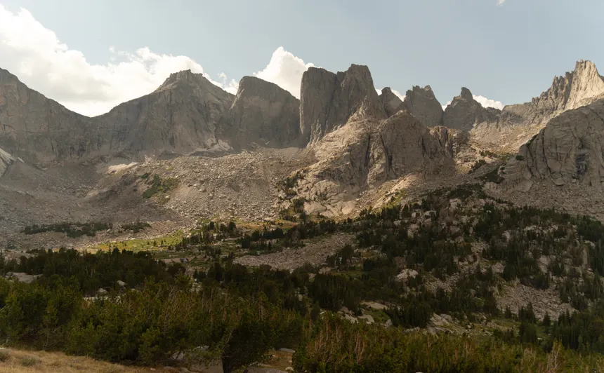
Titcomb Basin
If the Cirque is the range's most dramatic landscape, Titcomb Basin is its most ethereal. The basin sits at the head of the Fremont Creek drainage in the northern Winds, surrounded by the Fremont Glacier complex and the Continental Divide. Island Lake at 10,355 feet marks the entry to the basin; the valley extends several miles above, narrowing as it climbs toward the glaciers. The fishing in Titcomb Lakes is renowned. The approach from the Elkhart Park trailhead covers 16.5 miles one-way, most parties plan 4-6 days for a round-trip with camp time in the basin.
The Elkhart Park trailhead (near Pinedale) is the most commonly used entry for the central Winds. It sits at 9,440 feet and provides access not just to Titcomb but to dozens of other basins along the Continental Divide Trail. Backpackers who want to string multiple basins together often use Elkhart as the entry and exit for a loop that might cover 60-80 miles over 7-10 days.
Popo Agie Wilderness and Worthen Meadow
The southern Winds' Popo Agie Wilderness (pronounced Puh-PO-sha) is administered separately from the Bridger Wilderness and receives less traffic. The Worthen Meadow trailhead gives access to Stough Lakes, the Lizard Head Trail, and eventually the southern end of the crest. This area is lower than the main range crest, most camping is between 9,500 and 11,000 feet, and provides excellent fishing and more moderate terrain for less-experienced backpackers.
Planning a Wind River Range Trip
Permits
Most of the Bridger Wilderness has no camping permit requirement. A Wilderness Permit is required for entry, self-issue at the trailhead or online through the Forest Service. There is a fee of approximately $10-15 per person per day. Some specific zones (Cirque of the Towers camping area at Lonesome Lake being the primary example) have implemented a quota system, check the Bridger-Teton National Forest website for current restrictions, which change year to year as the agency tries to manage impact.
Wyoming requires a fishing license even in wilderness areas. Anglers can purchase a non-resident Wyoming fishing license online at wgfd.wyo.gov. The fishing in the Winds is genuinely excellent, Golden trout, cutthroat, brook, and brown trout in many lakes.
Bear Canisters
Bear canisters are required in the Bridger Wilderness. The most common canisters used in the Winds are the BearVault BV500 (fits 5-7 days of food for one person) and the Bearikade Weekender. Bear bags and bear lines are not permitted in the wilderness, canister only. This is a real factor in trip planning: your food must fit in the canister, which means testing your packing before the trailhead.
Water Filtration
The Winds have abundant water, snowmelt streams and alpine lakes everywhere. All water must be filtered or treated. Sawyer Squeeze and Katadyn BeFree are the most popular lightweight options. Giardia is present in the water supply, treatment is not optional. The high altitude means UV treatment (SteriPen) is effective too, though filter/squeeze systems are more reliable in cold water.
Navigation
The Winds are imperfectly signed. Many high routes and cross-country approaches have no maintained trail and minimal cairning. Topographic maps and compass skills are genuinely required. Download the relevant CalTopo or Gaia GPS maps offline before leaving cell service. The Pinedale Ranger District of Bridger-Teton National Forest sells paper topo maps at the district office, worth buying as backup.
Access and Trailheads
The main gateway towns are Pinedale (north and central Winds) and Boulder/Big Sandy (southern Winds). Pinedale is 2.5 hours from Jackson Hole, 3 hours from Salt Lake City. There is no direct way to reach the Winds without a vehicle, the trailheads are accessed via long drives on paved and gravel roads. High-clearance 4WD is helpful for the Big Sandy trailhead approach road (6 miles of rough dirt) but not always necessary. The Elkhart Park trailhead is fully paved.
Parking at the major trailheads fills on peak summer weekends. Arrive the evening before (many people camp in the parking lot) or early on weekend mornings. Weekday starts avoid the problem entirely.
Sample Route: Elkhart Park to Titcomb Basin (5 days)
Day 1: Elkhart Park (9,440 ft) → Elkhart Lake → Pine Creek Pass (10,700 ft) → camp near Seneca Lake. 10 miles, 1,800 ft gain.
Day 2: Seneca Lake → Island Lake → enter Titcomb Basin → camp upper Titcomb Lakes. 6 miles, 900 ft gain.
Day 3: Rest day in Titcomb Basin. Explore the upper basin, fish the lakes, acclimatize.
Day 4: Titcomb Basin → Island Lake → Indian Pass (11,800 ft) → camp near lower lakes. 8 miles, 1,400 ft gain, 1,500 ft descent.
Day 5: Return to Elkhart Park via Pole Creek Trail. 12 miles, 2,100 ft descent.
This route covers approximately 36 miles, reaches elevations above 11,800 feet, and passes through terrain that varies from dense lodgepole forest to open granite basin to glacial moraine. It's suitable for experienced backpackers in good physical condition, not a beginner route. The high elevation means altitude effects are real from day one.
Best Season
Mid-July through mid-September is the window. The high passes often hold snow into early July and can reclose with early September storms. Late July is generally optimal: snow is gone, trails are clear, and the weather is most stable. August is prime time but the most crowded at the most popular destinations. September thins the crowds dramatically and offers excellent conditions most years, just watch the forecast for early winter storms, which can arrive any time after Labor Day at higher elevations. Bring traction devices even in August for north-facing slopes above 11,000 feet.


