
Wind River Range, Wyoming:
A Hiking and Backpacking Itinerary
Four days in the "Winds": the granite amphitheater of the Cirque of the Towers, the alpine lakes of Titcomb Basin, Green River Lakes under Squaretop, and the wild glaciers below Gannett Peak.
Free interactive planner · drag & reorder your days, add stops, map it in minutes
Build your own Wind River Range trip, drag, reorder & map it.
Drag stops between days, swap the Cirque of the Towers for Titcomb Basin, and add your own lakes and passes with the place search. The live map and drive times recalculate as you go, and we will warn you before you build a day that is too much at 11,000 feet.
Opens a side panel · reorder days, add custom stops, see your route live
One range, granite towers, glaciers & alpine lakes, deep in Wyoming.
The Wind River Range, the "Winds" to those who know them, is one of the most remote and spectacular mountain ranges in the lower 48: a 100-mile granite spine running through west-central Wyoming, holding Gannett Peak (13,810 feet, the state high point), more than 40 named glaciers, and hundreds of alpine lakes. It is managed almost entirely as wilderness within the Bridger-Teton and Shoshone National Forests, with no entrance gate, no shuttle, and no crowds like the Tetons just to the north.
This 4-day route is built around Wind River Range hiking and a first taste of backpacking the range: the Cirque of the Towers, a granite amphitheater reached over Jackass Pass from the Big Sandy trailhead, and Titcomb Basin, the classic alpine-lake backpack up Pole Creek from Elkhart Park under Fremont Peak. You will also see Green River Lakes beneath Squaretop Mountain and pass Island and Seneca Lakes on the way in.
This is serious country. There are no facilities, no services, and no quick exits. It is grizzly habitat, so you must carry bear spray and store food in bear-proof containers. Mosquitoes are notorious in July, snow lingers on the high passes well into summer, and afternoon storms build fast. The best window is late July to mid September, and you should be comfortable with high altitude and self-sufficient travel before you go.
There is no lodging inside the wilderness, so base in Pinedale on the west side or Lander to the south and drive to the trailheads. Rooms in both towns are limited and fill on summer weekends, so book early. Most areas need no permit, but you must self-register at the trailhead and respect group-size limits. Buy bear spray and rent or bring a bear-proof food container before you arrive.

Drive in to Big Sandy · into the Cirque of the Towers
The Winds are remote: plan on about 1.5 to 2 hours from Jackson Hole (JAC), or come up from Riverton (RIW), with the final stretch on long gravel roads and no cell service. Aim for the Big Sandy trailhead, the classic southern gateway, and fuel up, fill water, and pick up bear spray in Pinedale or Lander before you commit to the dirt.
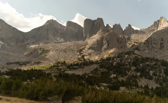
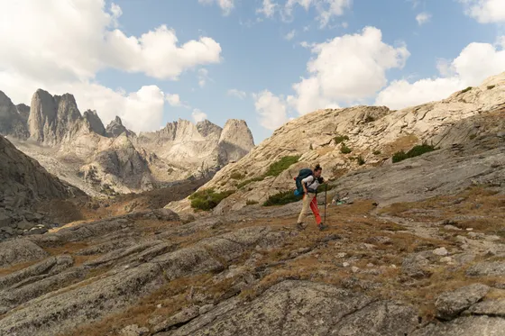
From Big Sandy, the trail climbs gently past Big Sandy Lake before tackling Jackass Pass, the rocky, boulder-strewn crossing that drops you into the Cirque of the Towers, a horseshoe of granite spires ringing Lonesome Lake. It is roughly 8 miles in, so most people backpack and camp on the approach or just outside the cirque (camping is restricted right at Lonesome Lake), then explore the amphitheater the next morning.
- ~8 mi in · strenuous · Big Sandy trailhead · granite amphitheater
- Fuel & bear spray in Pinedale or LanderNo services past the trailhead · gravel access roads
- Self-register at the trailheadNo permit needed · free · respect group-size limits
- Backpack camp on the approachCamp outside Lonesome Lake · grizzly country · bear-proof food
- There are no services past the trailhead. Fill your tank, water, and pick up bear spray in Pinedale or Lander before driving the gravel roads in.
- Jackass Pass is a rocky, boulder-strewn crossing, not a smooth trail. Take it slow with a full pack and watch your footing on the descent into the cirque.
- Camping is restricted right at Lonesome Lake to protect the basin. Camp on the approach or just outside the cirque and day-hike in.
Explore the Cirque · Lonesome Lake & the granite walls
Spend the day inside the Cirque of the Towers, the iconic granite amphitheater that draws climbers and backpackers from around the world. Wander the meadows around Lonesome Lake beneath Pingora, Wolf's Head, and the long sweep of towers, and watch climbers inch up the walls. This is a place to slow down: the light on the granite at dawn and dusk is the whole point.
If you have the legs, scramble up toward one of the high benches for a view back over the cirque and Lonesome Lake, or hike out toward Texas Pass for a different angle. Keep a clean camp, store all food in your bear-proof container away from your tent, and have bear spray within reach: this is active grizzly habitat, and afternoon thunderstorms can build fast over the spires.
- Granite amphitheater · Pingora & Wolf's Head · world-class climbing
- Granite at golden hourDawn and dusk light on the towers · the reason to camp here
- Keep a clean, bear-aware campFood in the canister away from the tent · spray within reach
- Second night near the cirqueBasecamp and day-explore · leave no trace
- This is active grizzly country. Store all food and scented items in a bear-proof container away from your tent, and keep bear spray on your hip, not in your pack.
- Afternoon thunderstorms build quickly over the spires. Do any high scrambling early and be off exposed terrain by early afternoon.
- The cirque is fragile and heavily used. Camp on durable surfaces, pack out everything, and use established sites to protect the meadows.
Reposition to Pinedale · up Pole Creek toward Titcomb Basin
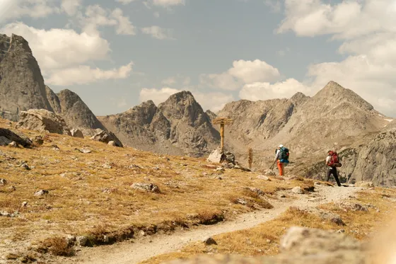
Hike back out over Jackass Pass to Big Sandy and reposition to the west side of the range. Drive to Pinedale, the friendly hub town, resupply, and head up to the Elkhart Park trailhead above town, the launch point for the range's most famous alpine-lake backpack. From here the Pole Creek / Titcomb Basin route runs roughly 25 to 30 miles round trip into the high heart of the Winds.
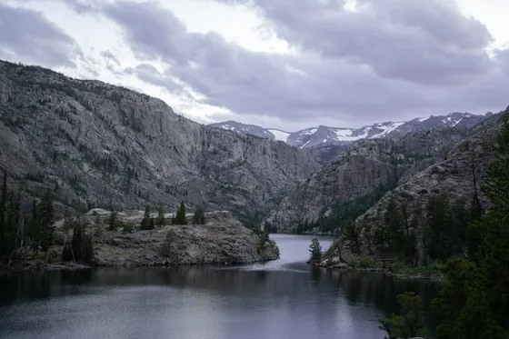
Start the climb past Seneca Lake and on toward Island Lake, a sapphire lake ringed by granite that makes a stunning first night and the classic gateway to Titcomb. Snow can linger on the higher sections of trail into summer, mosquitoes are fierce in July, and you are deep in grizzly country, so the same clean-camp, bear-aware rules apply all the way in.
- ~25 to 30 mi RT · Elkhart Park trailhead · classic Winds backpack
- Seneca Lake & Island LakeGranite-ringed alpine lakes · Island Lake camp · gateway to Titcomb
- Resupply in PinedaleHub town · last gas, food & water · Elkhart Park above town
- Camp at Island LakeSapphire lake under granite · grizzly country · bear-proof food
- Pinedale is the last real resupply on the west side. Top off gas, water, and food before driving up to the Elkhart Park trailhead.
- July mosquitoes in the Winds are legendary. Bring a head net and strong repellent, and pick breezier campsites near the lakes.
- Snow can linger on higher sections of the Pole Creek trail into summer. Check conditions at the Pinedale ranger station before you head up.
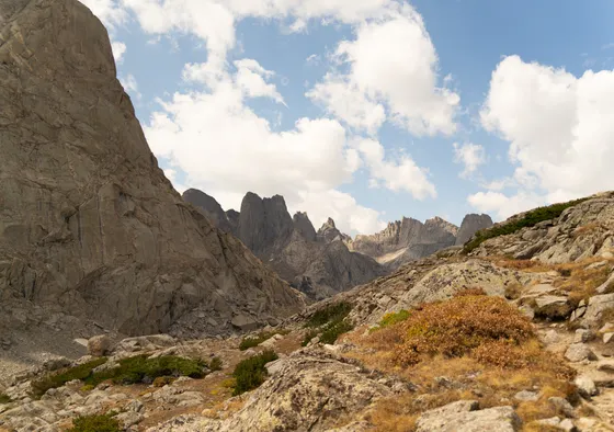
Titcomb Basin & Green River Lakes · the grand finale

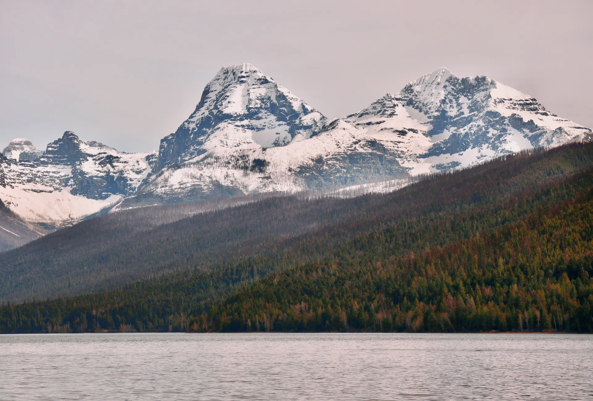
Push the last few miles up into Titcomb Basin, a glacier-carved corridor of linked alpine lakes hemmed in by sheer granite under Fremont Peak (13,745 feet), with the glaciers and Gannett Peak beyond. It is one of the great alpine basins in North America and the turnaround highlight of the trip. Soak it in, then hike back out to Elkhart Park.
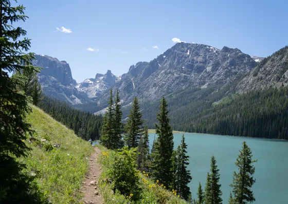
With extra time, swing north to Green River Lakes, where the perfect dome of Squaretop Mountain reflects in the water at one of the most photographed spots in Wyoming, a gentler, drive-up-and-day-hike alternative to the high passes. Getting home: from Pinedale it is roughly 1.5 to 2 hours back to Jackson (JAC), or head to Riverton (RIW), so fuel up and start the drive out with daylight to spare.
- Glacier-carved alpine basin · linked lakes · views toward Gannett Peak
- Squaretop Mountain reflected · drive-up day hike · most-photographed Winds view
- Getting home: Jackson or RivertonJAC ~1.5 to 2 hr from Pinedale · RIW alternative · fuel up first
- Titcomb Basin sits high and exposed. Watch the weather, turn around early if storms build, and give yourself room to get back below treeline.
- Green River Lakes is a far easier, drive-up alternative to the high passes, with the iconic Squaretop reflection right from the lakeshore.
- It is a long, remote drive back out. Fill up in Pinedale and leave with daylight for the 1.5 to 2 hour run to Jackson or the route to Riverton.
Now build your Wind River trip.
You have seen all four days. Open the free drag-and-drop planner and tune it for your dates, your fitness, and whether you base out of Pinedale on the west side or Lander to the south.
What we actually learned in the Winds.
No fee, but self-register and mind group limits
The Wind River Range has no entrance fee and most areas need no permit, but you must self-register at the trailhead. Wilderness rules apply, including group-size limits and no mechanized travel. Check the Bridger-Teton National Forest site for current closures and regulations before you go.
Carry bear spray and store food properly
This is active grizzly country. Carry bear spray on your hip where you can reach it, not buried in your pack, and store all food and scented items in a bear-proof canister away from your tent. Keep a clean camp and never leave food unattended.
Go late July to mid September
The reliable window is late July through mid September. Earlier and snow lingers on the high passes; July brings notorious mosquitoes, so pack a head net. Afternoon thunderstorms build fast over the peaks, so start early and be off exposed terrain by early afternoon.
Respect the altitude and remoteness
Trailheads sit near 9,000 feet and passes climb well above 11,000. Acclimatize, pace yourself, and know that there are no services, no quick exits, and little to no cell signal. Be fully self-sufficient and tell someone your route and return date.
Treat your water and pack it all out
The Winds are full of clear lakes and streams, but always filter or treat your water. There are no facilities, so practice strict leave-no-trace: pack out all trash, bury waste properly, and camp on durable surfaces away from lakeshores.
Base in Pinedale or Lander
There is no lodging in the wilderness. Pinedale serves the west-side trailheads (Elkhart Park, Green River Lakes) and Lander serves the south and east (Big Sandy, Sinks Canyon). Rooms are limited in both towns and fill on summer weekends, so book early.
Everything you'll actually want to know.
Ready to go? Get your
Wind River Range route.
Trailheads and mileages, the Cirque and Titcomb backpacks, grizzly and permit logistics, gateway-town lodging in Pinedale and Lander, and drive times from Jackson, so you can hike the Winds safely.
Instant book · Free cancellation · Secure payment via Stripe


Planning this trip?
Save it, share it with your crew, or find travelers heading the same way.

Liked this itinerary?
What other travelers are saying
Be the first to leave a tip or question for the next traveler.