The Other Side of the Mountain
Most people meet Mount Sneffels from Yankee Boy Basin on the south, because that is where the summit route starts. The Blue Lakes sit on the north side, reached from the Dallas Creek trailhead near Ridgway, and they are the reason a lot of people come to this range without any intention of climbing anything.
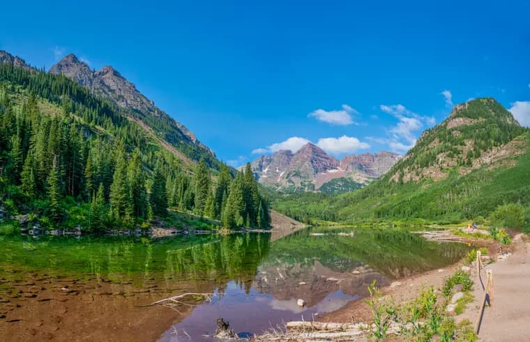
Three lakes stacked up a glacial basin, the lower one an improbable turquoise, with the Sneffels ridgeline standing over them.
The Mileage
Lower Blue Lake: about 6.5 miles round trip with roughly 1,680 feet of gain. This is the version most people do, and it is a solid half-day.
Middle and Upper Blue Lakes: above the lower lake, on steeper ground, adding distance and climbing for a quieter basin.
Blue Lakes Pass: about 9 miles round trip with something close to 3,800 feet of gain. A serious day, and the point at which the trail becomes a connection rather than a destination.
Through to Yankee Boy Basin: carrying on over the pass and down the far side makes roughly 15 miles with 5,000-plus feet of gain, and needs two cars or a very understanding friend.
Climbing Sneffels From Blue Lakes
You can reach the summit from this side by climbing to Blue Lakes Pass and joining the upper mountain from there, and parties on the hut traverse sometimes do exactly that. Understand what you are taking on: it is far longer and involves substantially more climbing than the standard Yankee Boy Basin route, and it still ends in the same Class 3 terrain. If the summit is your objective, the south side is the sensible approach. If the lakes are your objective, stay at the lakes.
Crowds and Timing
This is a popular trail and the parking fills early on summer weekends. Start early, both for the parking and for the storms. Mid-July gives you wildflowers through the basin, and late September gives you aspen colour on the drive in from Ridgway.
Camping
People do camp at the lower lake, and it is a beautiful place to wake up. It is also a heavily used basin, so camp on durable ground well back from the water, pack out everything, and do not build a fire ring.
The Rules Changed in 2026
This matters more than anything else on this page, because Blue Lakes has been loved close to death and the Forest Service has responded. New requirements took effect in the Mount Sneffels Wilderness, East Dallas (Blue Lakes) area on May 31, 2026:
- Human waste must be packed out. Bring a wag bag. This is not optional and there are no toilets up there.
- Bear-resistant food storage is required.
- Overnight groups are capped at six people, with a maximum two night stay.
- Camping is no longer allowed at the middle and upper lakes. If your plan was a sunrise shot from a tent above the lower lake, that plan is gone.
- Camp at least 100 feet from trails and water, and campfires remain prohibited.
Camping at the lower lake is first come, first served and the space is genuinely limited. Arriving late on a Friday in July with no backup plan is how people end up hiking out in the dark.
Permits: Free Now, Probably Not for Long
No permit is required to hike or camp at Blue Lakes through 2026. The Forest Service has proposed a fee system that would start as soon as 2027, in the region of $5 per person for a day visit and $25 for a campsite, running June through September and booked through Recreation.gov.
Nothing is final until it is published, so check the Grand Mesa, Uncompahgre and Gunnison National Forests page before you drive. If you have been putting this trail off, the free window is closing.
Getting There
The Blue Lakes trailhead sits southwest of Ridgway, up County Road 7 (Dallas Creek Road). This is the opposite side of the range from Yankee Boy Basin, and it is the friendlier drive: a normal car gets to this trailhead, which is not true of the upper trailhead on the south side.
The parking area fills early on summer weekends. Treat a 6 AM arrival as normal rather than keen.
How This Connects to the Summit
Blue Lakes Pass, reached at roughly 3.9 miles, is where the hiking trail meets the mountaineering. From the pass, the southwest ridge continues toward the summit, and that is a serious step up in difficulty from the trail you walked to get there. Most people who come to Blue Lakes are here for the lakes, and they are right to be. The water really is that colour.
If you want the summit instead, the standard route from Yankee Boy Basin is shorter and easier than anything starting from this side.
Blue Lakes and Mount Sneffels: The Northern Approach FAQs
About 6.5 miles round trip to Lower Blue Lake with roughly 1,680 feet of gain. Continuing to Blue Lakes Pass makes it around 9 miles round trip with close to 3,800 feet of gain, and carrying on through to Yankee Boy Basin makes roughly 15 miles with over 5,000 feet.
Yes, by climbing to Blue Lakes Pass and joining the upper mountain from there, but it is much longer and involves far more elevation gain than the standard route from Yankee Boy Basin, and it finishes in the same Class 3 terrain. If the summit is the goal, approach from the south.
At the Dallas Creek trailhead on the north side of the Sneffels Range, reached from Ridgway. That is the opposite side of the mountain from Yankee Boy Basin and Ouray, where the summit route begins.
Yes, and the lower lake is a popular spot. It is a heavily used basin though, so camp on durable ground well back from the shoreline, pack everything out, and do not build fire rings.
July through September. Mid-July brings wildflowers through the basin and late September brings aspen colour on the drive in from Ridgway. Arrive early on summer weekends, because the parking fills and afternoon thunderstorms are routine.
Not through 2026. A fee system has been proposed that could begin in 2027, in the range of $5 per person for a day hike and $25 for a campsite, June through September, booked on Recreation.gov. Check the Forest Service page before you go, because the proposal was still moving in 2026.
No. As of May 31, 2026, camping is prohibited at the middle and upper lakes. Camping is limited to the lower lake area, first come and first served, at least 100 feet from trails and water, with a maximum stay of two nights.
Pack out human waste, use bear-resistant food storage, keep overnight groups to six people or fewer, camp only at the lower lake and at least 100 feet from trails and water, stay a maximum of two nights, and light no campfires.
Yes. The trailhead is southwest of Ridgway up County Road 7 and does not need four-wheel drive, unlike the upper trailhead in Yankee Boy Basin on the south side of the range. The lot fills early on summer weekends.
Yes. The worked day-by-day plan is Mt Sneffels Hike: A 3-Day Colorado 14er Itinerary (3 Days), with the permits, the stays and the drive times already sorted. Tell us your dates and we will put it together for you and confirm what is genuinely open on those days. Asking is free: no card, no deposit, and nothing is held until you say yes.