Maroon Bells Four Passes Loop:
Backpacking Guide
Colorado's iconic Four Passes Loop: 26.3 miles, four passes above 12,000 feet, and one of the finest backpacking loops in the Rocky Mountain West. Wilderness permits required.
Free interactive planner · drag & reorder your days, add stops, map it in minutes
Build your own Four Passes Loop, drag, reorder & map it.
Drag camps and passes between days, swap in the Snowmass Lake side trip, and add your own stops with the place search. The live map and mileages recalculate as you go, and we'll warn you before you stack two 12,000-foot passes into a day no one enjoys.
Opens a side panel · reorder days, add custom stops, see your route live
One loop, four passes above 12,000 feet, the best of Colorado.
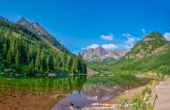
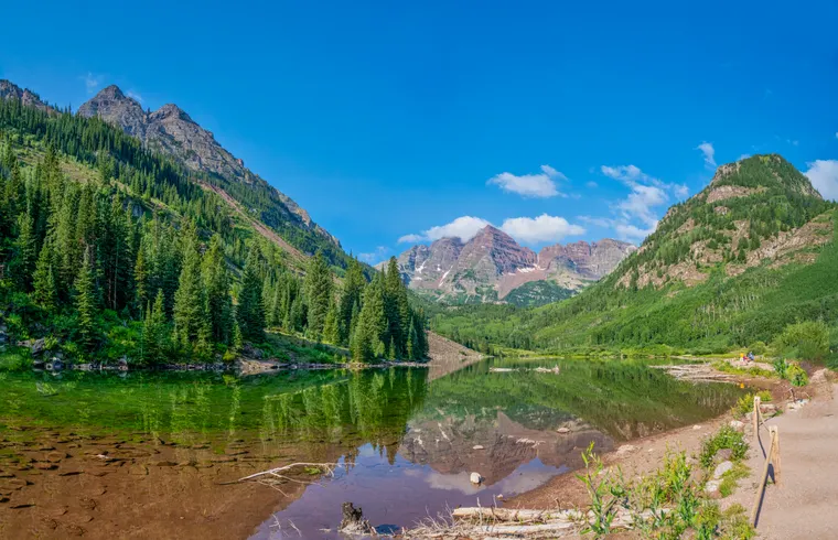
The Maroon Bells are the most photographed mountains in Colorado, two 14,000-foot peaks reflected in Maroon Lake at dawn, a postcard image that has appeared in more travel magazines than almost any other American landscape. What most visitors never see is what lies behind them: 181,000 acres of designated wilderness, a high alpine route connecting four passes above 12,000 feet, and one of the finest backpacking loops in the entire Rocky Mountain West.
The Four Passes Loop runs 26.3 miles through the Maroon Bells-Snowmass Wilderness, crossing West Maroon Pass, Frigid Air Pass, Trail Rider Pass, and Buckskin Pass, each one above 12,400 feet, each one with views that stop you mid-stride. This is not a casual trip. The total elevation gain is approximately 8,000 feet, most of it on rough, rocky trail above treeline. What it rewards is a Colorado that very few people will ever see.
The loop is most commonly hiked counterclockwise, starting on the West Maroon Creek Trail, crossing West Maroon Pass first, and saving the dramatic approach back to Maroon Lake via Buckskin Pass for the final day. This saves the best views of the Bells themselves for when you are tired and most need the motivation. Some hikers prefer clockwise to avoid the steep descent on the west side of Buckskin Pass; either direction works, and both are well-marked.
Timing matters here more than almost anywhere in Colorado. The weather at Maroon Bells is true high alpine: Maroon Lake sits near 9,600 feet, afternoon thunderstorms build fast in July and August, and snow is possible in any month of the year, so pack layers even in midsummer. And if you can land a September permit, the fall colors at Maroon Bells are among the best in the state, with the aspen groves along the first miles of trail typically turning solid gold from roughly mid to late September. A late-season loop doubles as world-class leaf peeping, just expect cold nights at camp.
Overnight camping in the Maroon Bells-Snowmass Wilderness requires a permit. The most popular zones (Crater Lake, West Maroon, Fravert Basin) fill on March 1, the day reservations open, often within minutes. Permits cost $10/person/night plus a $6 reservation fee on recreation.gov. The trailhead shuttle from Aspen Highlands is mandatory in season, so buy tickets ahead on rfta.com, and bear canisters are required by regulation.
Maroon Lake to Crater Lake Area · 3.5 miles, 1,100 ft gain
Take the RFTA shuttle from Aspen Highlands to the Maroon Lake trailhead. Walk through the crowds at Maroon Lake (you'll have the backcountry to yourself by the time you reach your campsite) and follow the West Maroon Creek Trail south along the valley floor. The trail climbs gradually through aspen groves and wildflower meadows below the rust-red faces of the Maroon Bells.
Camp near Crater Lake at roughly 3.5 miles, your permit will specify which zone you are in, and designated sites are well-signed. Crater Lake sits in a glacial cirque directly below the south face of South Maroon Peak. From your campsite, the Bells dominate the skyline at eye level. Set up camp early, fill water from the creek (filter required), and watch the light on the peaks go gold at sunset.
- Mandatory in season · ~$10 round trip · every 20 minutes
- ~3.5 mi · 1,100 ft gain · aspen groves & wildflower meadows
- Filter water at Crater LakeFill from the creek · filter required
- Camp near Crater LakeGlacial cirque below South Maroon Peak · designated sites
- The RFTA shuttle runs from Aspen Highlands to Maroon Lake roughly every 20 minutes, about 6am to 7pm. Private vehicles are not permitted past the Aspen Highlands parking area from late June through early October.
- Your overnight permit specifies which zone you can camp in. The most popular zones (Crater Lake, West Maroon, Fravert Basin) fill on March 1 within minutes of reservations opening.
- Set up camp early at Crater Lake and watch the light go gold on the Bells at sunset. Fill water from the creek with a filter.
Maroon LakeWest Maroon CreekWest Maroon Pass and Fravert Basin · 7-9 miles, 2,400 ft gain
 Fravert BasinSchofield Park
This is the most scenic day on the loop. The trail climbs 2,400 feet from the valley floor to the crest of West Maroon Pass at 12,500 feet. The switchbacks above Crater Lake are steep and rocky; above treeline, the route crosses wide open tundra with views back to the Bells that grow more impressive with every step.
The pass itself sits on the boundary between Pitkin and Gunnison Counties. On the far side, the trail descends steeply into the headwaters of the East Fork Crystal River, passing through a landscape that feels genuinely remote, wide valley, no crowds, just the sound of wind and water. The descent reaches Schofield Park, a high alpine meadow at around 10,200 feet, before the trail climbs again toward Fravert Basin. Camp in the basin; it is one of the quieter nights on the loop.
- 2,400 ft climb from the valley floor · steep, rocky switchbacks
- Open tundra above treelineViews back to the Bells that grow with every step
- Descend to Schofield ParkHigh alpine meadow · ~10,200 ft · East Fork Crystal River
- Camp in Fravert BasinOne of the quieter nights on the loop
- The switchbacks above Crater Lake are steep and rocky. Pace yourself on the 2,400-foot climb to West Maroon Pass at 12,500 feet.
- West Maroon Pass sits on the boundary between Pitkin and Gunnison Counties. The far side descends into the genuinely remote headwaters of the East Fork Crystal River.
- Fravert Basin is one of the quieter nights on the loop, a good place to rest before the two-pass day ahead.
Frigid Air Pass and Trail Rider Pass · 8-10 miles, 2,800 ft gain
Day 3 crosses two passes back-to-back and is the most demanding section of the loop. Start early. From Fravert Basin, the trail climbs to Frigid Air Pass at 12,400 feet, a wide saddle with views south into the Snowmass Creek drainage. The descent drops you into the upper Snowmass Creek valley, where the optional side trip to Snowmass Lake (5 miles round trip, 800 ft additional gain) is one of the most spectacular detours in all of Colorado. Snowmass Lake sits in a bowl below Snowmass Mountain (14,092 ft), glacially carved and a perfect deep blue even in late summer. Skip it only if weather is moving in or you are behind schedule.
From the Snowmass Creek junction, the trail climbs again to Trail Rider Pass at 12,420 feet, the fourth and final named pass on the loop. The climb is relentless, about 2,200 feet from the valley floor, but the top delivers views of Snowmass Mountain, Capitol Peak, and Hagerman Peak all at once. Camp near timberline below the pass in the Geneva Lake drainage.
- Wide saddle · views into the Snowmass Creek drainage
- Snowmass Lake side trip (optional)~5 mi RT · 800 ft gain · below Snowmass Mountain (14,092 ft) · deep blue alpine lake
- ~2,200 ft climb · views of Snowmass, Capitol & Hagerman Peaks
- Camp in the Geneva Lake drainageNear timberline below Trail Rider Pass
- Day 3 is the most demanding section of the loop, crossing Frigid Air Pass and Trail Rider Pass back-to-back. Start early to beat afternoon storms.
- The Snowmass Lake side trip adds about 5 miles round trip and 800 feet of gain. It is one of the most spectacular detours in Colorado, so skip it only if weather is moving in or you are behind schedule.
- The climb to Trail Rider Pass at 12,420 feet is relentless, about 2,200 feet, but the top delivers Snowmass Mountain, Capitol Peak, and Hagerman Peak all at once.
Trail Rider PassFrigid Air PassBuckskin Pass and Return to Maroon Lake · 5.5 miles, 1,200 ft gain
 Minnehaha GulchBack to Maroon Lake
The final day is the shortest but psychologically the most rewarding. From camp, the trail climbs to Buckskin Pass at 12,462 feet, the highest point on the loop, where the North Maroon Peak and South Maroon Peak suddenly reappear ahead of you, now from the opposite side than you saw on Day 1. The descent from Buckskin is steep and rocky on loose talus; trekking poles help significantly. Below treeline, the trail enters the Minnehaha Gulch and joins the Crater Lake Trail, returning to Maroon Lake and the shuttle stop.
If you are on a 3-day schedule, you will combine Days 3 and 4 into a very long day (15-18 miles). This is achievable for fit, experienced backpackers, but requires a 5am start and no side trips to Snowmass Lake.
- The highest point on the loop · the Bells reappear from the far side
- Descend Minnehaha Gulch to Crater Lake TrailSteep, rocky talus · trekking poles help significantly
- Catch the RFTA shuttle back to Aspen Highlands
- Buckskin Pass at 12,462 feet is the highest point on the loop. The Maroon Bells reappear from the opposite side than you saw on Day 1, a strong morale boost on the final climb.
- The descent from Buckskin is steep and rocky on loose talus. Trekking poles help significantly through Minnehaha Gulch down to the Crater Lake Trail.
- On a 3-day schedule you combine Days 3 and 4 into a 15 to 18 mile day. It is achievable for fit, experienced backpackers but requires a 5am start and no Snowmass Lake side trip.
Now build your Four Passes Loop.
You've seen all four days. Open the free drag-and-drop planner and tune it for your dates, your pace, and whether you push 3 days or take the loop at a comfortable 4.
What we actually learned on the loop.
Overnight wilderness permit required
Overnight camping in the Maroon Bells-Snowmass Wilderness requires a permit, June 1 through October 31. It costs $10/person/night plus a $6 reservation fee on recreation.gov. Reservations open March 1 and the most popular zones (Crater Lake, West Maroon, Fravert Basin) fill within minutes. If you miss the March 1 window, walk-up permits are available at the Aspen Ranger District office starting at 8am, so plan to arrive by 7am in July and August.
The trailhead shuttle is mandatory
From late June through early October, private vehicles are not permitted past the Aspen Highlands parking area. The RFTA shuttle runs to Maroon Lake every 20 minutes, roughly 6am to 7pm, for about $10 round trip. Buy tickets ahead on rfta.com. To start before the first shuttle, bike the 9.5-mile road or camp the night before at Maroon Lake Campground (a separate reservation).
Bear canisters are required by regulation
Bear canisters are required in the Maroon Bells-Snowmass Wilderness, not just recommended, required. Bring a BearVault BV500, BV450, or equivalent IGBC-approved canister. Hang systems are not permitted as a substitute. Black bears are active all summer, particularly near berry patches in late August and September. Food, toiletries, and anything scented must go in the canister, not in your tent.
No campfires above 11,500 feet
Campfires are prohibited above 11,500 feet in the Maroon Bells-Snowmass Wilderness. At lower elevations, fires are allowed only in existing fire rings where available. The best practice at this altitude is a stove: faster, lighter, and less damaging.
Leave No Trace at altitude
Bury human waste in a cathole 6 to 8 inches deep, at least 200 feet from any water source or trail. Pack out all trash including food scraps and fruit peels. Filter all water; creeks and lakes look clean but still need treatment.
Respect the elevation and the weather
Most of the 8,000 feet of gain is on rough, rocky trail above treeline, with four passes above 12,400 feet. Acclimatize before you start, start each pass early, and be off the high ground before afternoon thunderstorms build. This is a strenuous trip, not a beginner one.
Everything you'll actually want to know.
Ready to go? Get your
Four Passes Loop route.
Trailheads and mileages, the four passes, permit and shuttle logistics, the Snowmass Lake side trip, bear-canister rules, and the camp-by-camp plan you need to backpack the Maroon Bells safely.
Instant book · Free cancellation · Secure payment via Stripe
Know these trails yourself? Become a local guide and host free community hikes.

Planning this trip?
Save it, share it with your crew, or find travelers heading the same way.
What other travelers are saying
Be the first to leave a tip or question for the next traveler.
How was your experience?
Tell us what worked and what did not. It goes straight to Yulia and Margarita.