Black Canyon of the Gunnison:
A 2-Day Itinerary
Two days at one of the steepest, deepest, narrowest canyons in North America: the South Rim Drive overlooks, Painted Wall, the best rim hikes, and Dark Sky stargazing above the Gunnison River.
Free interactive planner · drag & reorder your days, add stops, map it in minutes
Build your own Black Canyon trip, drag, reorder & map it.
Drag stops between days, swap overlooks and rim hikes, and add your own viewpoints with the place search. The live map and drive times recalculate as you go, so you can tune the South Rim Drive around sunrise, sunset, and the stargazing you came for.
Opens a side panel · reorder days, add custom stops, see your route live
One park, the deepest, darkest canyon, in western Colorado.
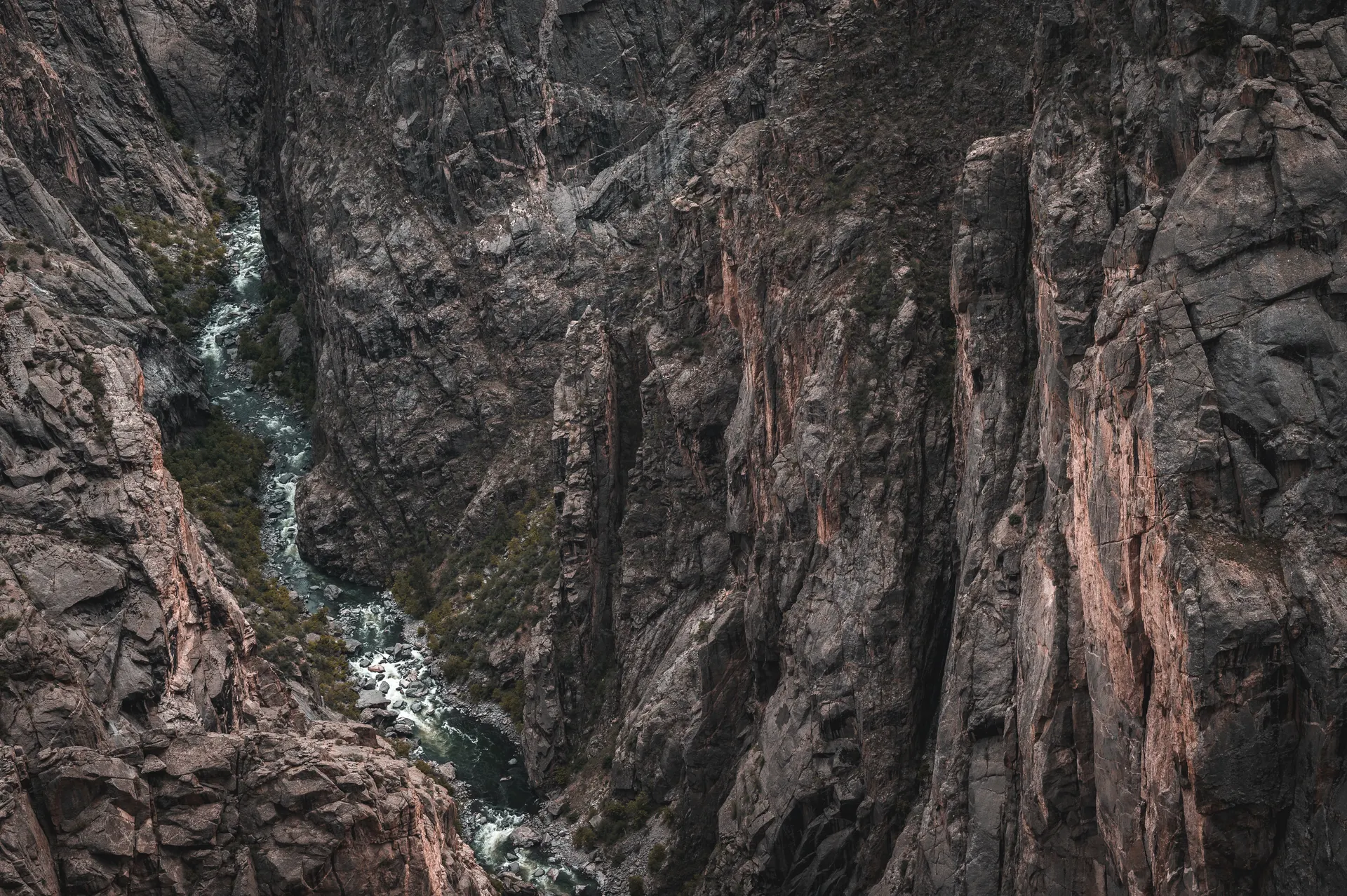
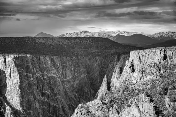
Black Canyon of the Gunnison is one of the steepest, deepest, and narrowest canyons in North America. Its sheer dark walls plunge more than 2,000 feet to the Gunnison River below, and in the narrowest stretches the gorge is so deep and tight that parts of it get only a few minutes of direct sunlight a day, which is exactly how the canyon got its name.
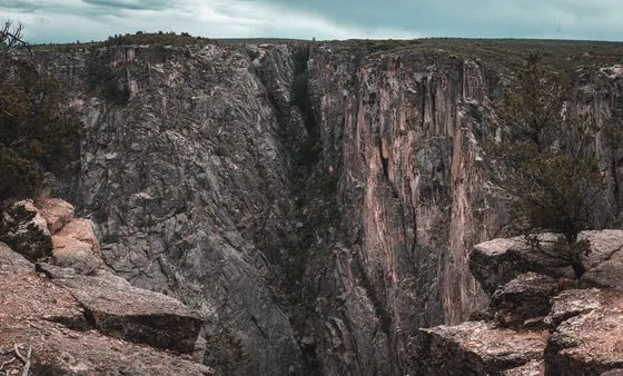
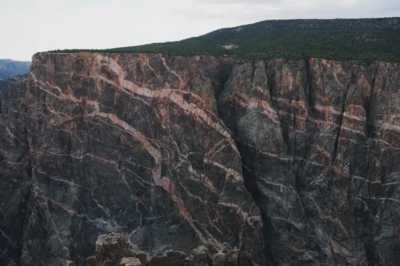
This 2-day route is built around Black Canyon of the Gunnison hiking and the views from above: the paved South Rim Drive with its string of vertigo-inducing overlooks, Painted Wall (the highest cliff in Colorado at 2,250 feet), and the two best rim hikes, the Rim Rock / Oak Flat loop and the Warner Point Nature Trail. It is a far less crowded park than Colorado's big names, which is part of the appeal.
The South Rim Road and most facilities are seasonal: the road past the visitor center closes in winter, and the remote North Rim is reached only by gravel and shuts down in the cold months. Late spring through early fall is the prime window. This is also a certified International Dark Sky park, so plan to stay out after dark at least one night.
The South Rim Campground is the only in-park lodging and fills on summer weekends, so reserve through recreation.gov ahead. Most people base in Montrose, about 15 minutes from the South Rim entrance, which has the closest hotels, gas, and supplies. The strenuous inner canyon routes need a free wilderness use permit from the visitor center, and there is no maintained trail to the river.


The South Rim Drive · overlooks & Painted Wall
Get to the park early. From Montrose it is about 15 minutes to the South Rim entrance, and you will want time at the visitor center near Gunnison Point for the orientation, the canyon geology, and the free wilderness use permit if you plan any inner canyon scrambling. Then start working your way along the paved South Rim Drive, the main scenic road, stopping at the short walks out to each overlook.
Hit the classics in turn: Pulpit Rock and Chasm View, where the gorge pinches to its narrowest and you stare straight down 1,800 feet to the river, then Painted Wall View, looking across at the highest cliff in Colorado, a 2,250-foot wall streaked with pale pegmatite. Finish the day at Sunset View as the light goes warm on the rock. Most overlooks are short paved walks from the road, so this is an easy but unforgettable day.
- Gunnison Point, Pulpit Rock, Chasm View, Painted Wall, Sunset View · short walks
- The highest cliff in Colorado · 2,250 ft · pale pegmatite streaks
- Near Gunnison Point · free permit for inner canyon routes
- Stay in Montrose or the South Rim CampgroundMontrose ~15 min out · in-park campground books ahead in summer
- The South Rim Drive is the main paved road and the heart of the park. Pull off at every overlook, since each one is a short walk and shows a different angle of the gorge.
- Painted Wall View looks across at the highest cliff in Colorado, 2,250 feet tall. It photographs best in the warmer light of early morning or late afternoon.
- The road past the visitor center closes for the winter, so check the park status before you go in spring or fall.

Rim hikes, the inner canyon & Dark Sky stars


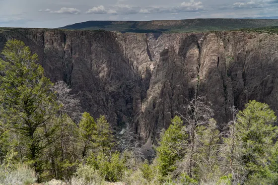
Spend the morning on the two best rim hikes. The Rim Rock / Oak Flat Loop (about 2 miles) dips below the rim through scrub and pinyon-juniper for the only easy taste of being inside the canyon, while the Warner Point Nature Trail (about 1.5 miles round trip) runs out to the end of the South Rim Drive for a wide-open view down the canyon and across the valley to the San Juan and West Elk mountains. Both are short and rewarding, and neither requires a permit.
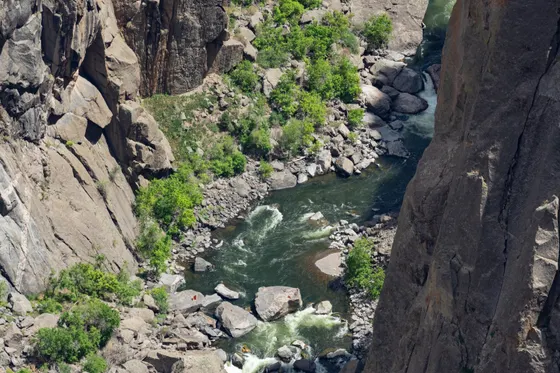
If you are an experienced, fit scrambler, the park's real challenge is the unmaintained inner canyon routes like the Gunnison Route and S.O.B. Draw, which drop roughly 1,800 to 2,700 feet to the river over loose rock, brush, and a fixed chain. These need a free wilderness use permit and serious scrambling experience, and there is no maintained trail. The inner gorge is also famous for Gold Medal trout fishing and expert-level kayaking and rock climbing. End your trip after dark: this is a certified Dark Sky park, so find an overlook and stay out for the stars.
- ~2 mi · dips below the rim · the easy way to feel inside the canyon
- ~1.5 mi RT · end of the South Rim Drive · wide canyon and mountain views
- Gunnison Route, S.O.B. Draw · unmaintained · free wilderness permit required
- Certified Dark Sky park · stay out after dark at an overlook
- The Oak Flat and Warner Point rim hikes are short, do not need a permit, and give you the two best on-foot experiences without dropping into the gorge.
- The inner canyon routes are steep, unmaintained scrambles down loose rock with a fixed chain, not trails. Only attempt them if you are fit and experienced, and pick up the free wilderness use permit first.
- Black Canyon is a certified International Dark Sky park. Plan one night around the stars and bring a headlamp, warm layers, and a red light to protect your night vision.
Now build your Black Canyon trip.
You've seen both days. Open the free drag-and-drop planner and tune it for your dates, your pace, and whether you base in Montrose just outside the South Rim or over in Gunnison.
What we actually learned on the rim.
Pay the entrance fee or bring your pass
Black Canyon of the Gunnison charges about $30 per vehicle for a 7-day pass. The annual America the Beautiful pass ($80) also covers entry and pays off fast if you visit other national parks. Pay at the South Rim entrance or online ahead of time.
Go late spring through early fall
The South Rim Road past the visitor center closes for the winter, and the remote North Rim and its gravel access close in the cold months too. May through September is the prime window, with the most facilities open and the best access to the overlooks and rim hikes.
The inner canyon is no joke
There is no maintained trail to the Gunnison River. Routes like the Gunnison Route and S.O.B. Draw are steep, unmaintained scrambles down 1,800 to 2,700 feet of loose rock and brush, with a fixed chain on the worst pitch. They require a free wilderness use permit and serious experience.
It is a world-class river below
The inner gorge holds Gold Medal trout fishing, expert-only whitewater kayaking, and big-wall rock climbing. All of it is for experienced, self-sufficient parties only, and most of it requires a wilderness permit from the visitor center.
Base in Montrose, or camp the South Rim
Montrose sits about 15 minutes from the South Rim entrance and has the closest hotels, gas, and groceries. The in-park South Rim Campground is the only lodging inside the park and fills on summer weekends, so reserve through recreation.gov ahead. Gunnison is the other nearby base.
Stay for the dark sky
Black Canyon is a certified International Dark Sky park, with some of the darkest skies in Colorado. Plan at least one night around stargazing from an overlook, and pack a headlamp, warm layers, and a red light to keep your night vision.
Everything you'll actually want to know.
Ready to go? Get your
Black Canyon route.
Every South Rim overlook in order, the best rim hikes, inner canyon route notes, the free permit, drive times from Montrose, and the Dark Sky timing you need to do Black Canyon right.
Instant book · Free cancellation · Secure payment via Stripe
Planning this trip?
Save it, share it with your crew, or find travelers heading the same way.

Liked this itinerary?
What other travelers are saying
Be the first to leave a tip or question for the next traveler.