
Three Days on Big Sur:
Waterfalls, Cliffs & Highway 1
Three days on the best hiking in Big Sur: McWay Falls and the Ewoldsen Trail at Julia Pfeiffer Burns, the Pfeiffer Falls and Buzzards Roost loops, and the headlands at Andrew Molera, all strung along Highway 1.
Free interactive planner · drag & reorder your days, add stops, map it in minutes
Build your own Big Sur trip, drag, reorder & map it.
Drag stops between days, swap trails, and add your own overlooks and beaches with the place search. The live map and drive times recalculate as you go, and we'll flag the long, winding Highway 1 legs before you cram too much into one foggy morning.
Opens a side panel · reorder days, add custom stops, see your route live
Redwoods, waterfalls & the wildest coast in California.
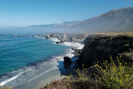
Big Sur is the rugged 90-mile stretch of central California coast where the Santa Lucia Mountains drop straight into the Pacific and Highway 1 (CA-1) clings to the cliffs above. There are no big towns out here, just redwood canyons, hidden waterfalls, and turnouts where the fog peels back to reveal the bluest water in California. It is one of the most scenic drives on earth, and the hiking trails in Big Sur, California are every bit as good as the views.
This 3-day route is built around the best hiking in Big Sur: the iconic McWay Falls overlook and the redwood-and-coast Ewoldsen Trail at Julia Pfeiffer Burns State Park, the Pfeiffer Falls and Buzzards Roost loops in Pfeiffer Big Sur State Park, and the headlands and beach at Andrew Molera. We weave in Bixby Creek Bridge, purple-sand Pfeiffer Beach, and an optional Monterey Bay paddle on the way in or out.
Fall (September through November) brings the clearest skies and the least fog, with warm, calm days. Summer is gorgeous but often socked in with marine fog until midday, and Highway 1 is busiest then. Whenever you go, check Caltrans for CA-1 conditions before you drive: this road periodically closes for landslides, sometimes for months at a time.
Lodging in Big Sur proper is limited and expensive: Big Sur Lodge, Ventana, and Post Ranch Inn all book far ahead, often months out. If they are full or out of budget, base in Carmel-by-the-Sea or Monterey and drive in. Gas and cell service are scarce along Highway 1, so fill up in Carmel or Monterey, download offline maps, and check Caltrans for any CA-1 closures before you set out.
Drive the coast in · Bixby Bridge & Andrew Molera
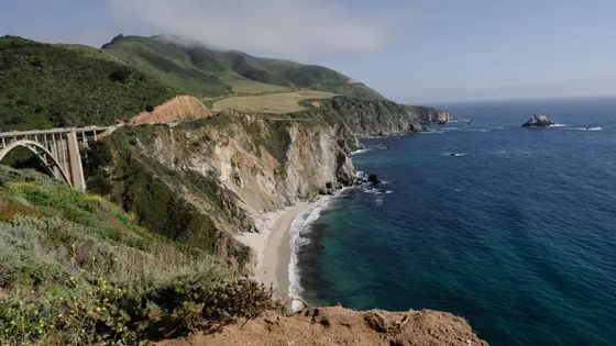
Start in Monterey or Carmel-by-the-Sea and drive south on Highway 1 into Big Sur. The first stretch is a greatest-hits reel: pull over at Bixby Creek Bridge, the most photographed span on the coast, and at the turnoff to Point Sur Lighthouse on its volcanic headland. Take it slow, the road is narrow and winding, and the turnouts are the whole point.
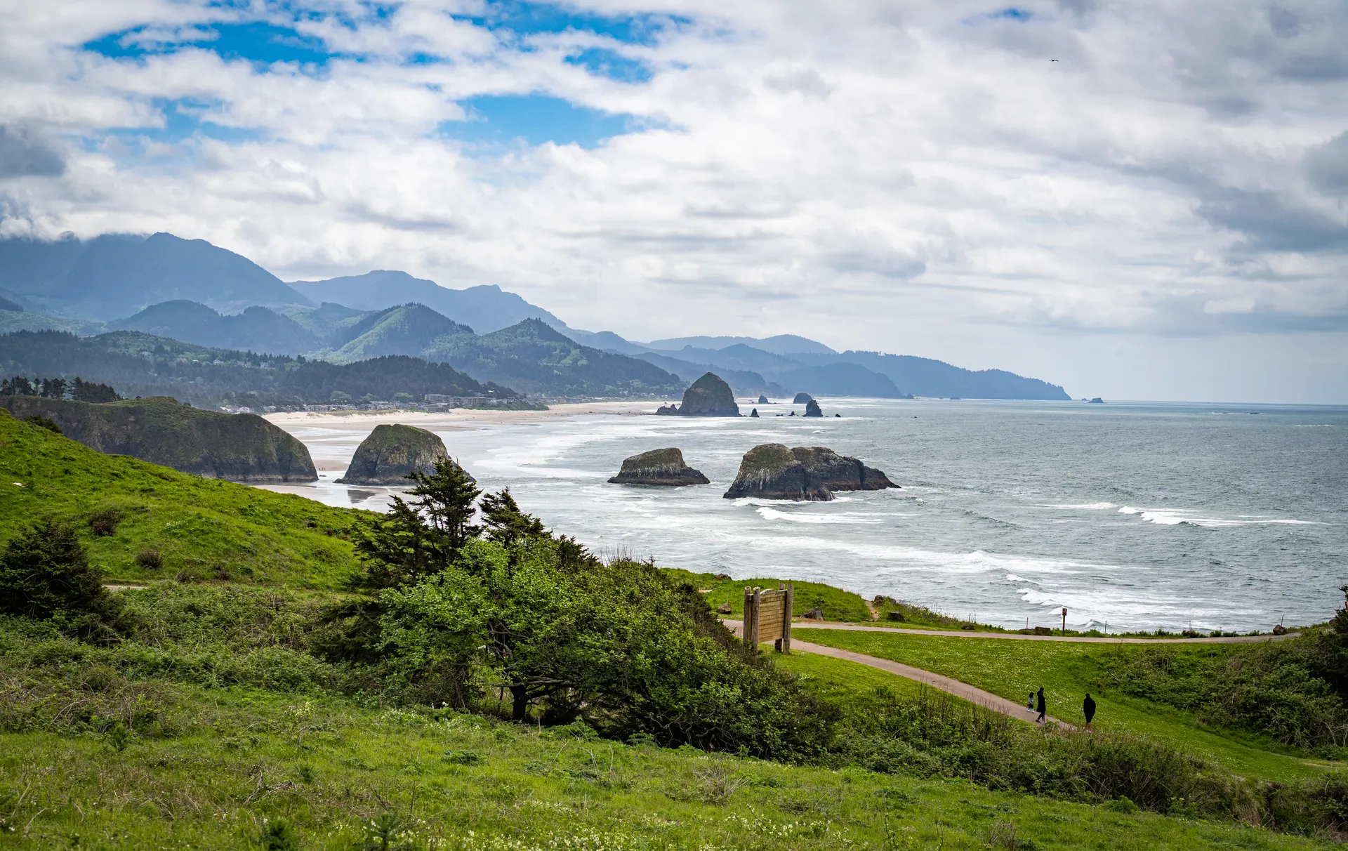
Stretch your legs at Andrew Molera State Park, the wildest of the Big Sur parks. The full Andrew Molera Loop runs about 8 miles over the headlands, but you can do shorter out-and-backs to the beach and bluffs. Note the trail to the beach fords the Big Sur River, which is easy in late summer and fall but can be deep or impassable in the wet season, so check before you commit.
- Bixby Creek Bridge viewpointThe iconic Highway 1 span · turnouts on both sides · go early to park
- Lighthouse on a volcanic headland · guided tours only · check schedule
- ~8 mi loop or shorter beach/bluff options · seasonal river ford
- Settle into Big Sur, Carmel, or MontereyBig Sur lodging is limited · Carmel and Monterey are easy fallbacks
- Check Caltrans (CA-1 conditions) before you drive. Highway 1 periodically closes for landslides, sometimes for months, which can cut Big Sur off from one direction.
- The Bixby Bridge turnouts are small and fill fast in season. Arrive early or late in the day, and never stop on the bridge itself.
- The Andrew Molera beach trail fords the Big Sur River. It is usually easy in late summer and fall but can be deep or impassable after winter rain, so check conditions at the trailhead.
 Andrew Molera
 Point Sur
Redwood loops in Pfeiffer Big Sur · Pfeiffer Falls & Buzzards Roost
Pfeiffer BeachBig Sur coastSpend the morning inland among the redwoods at Pfeiffer Big Sur State Park. The Pfeiffer Falls / Valley View Loop (about 2 miles) climbs a fern-lined canyon to a slender 60-foot waterfall, then up to the Valley View overlook above the Big Sur River gorge. It is the easiest way to sample the best hiking in Big Sur without a big day on your feet.
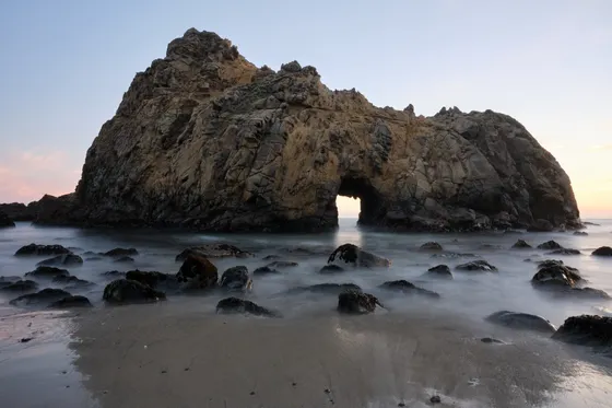
In the afternoon, take on Buzzards Roost (about 3 miles, moderate), a quieter loop that climbs out of the redwoods to a ridgetop with views over the river valley and out to the ocean. Cap the day at Pfeiffer Beach, reached by a narrow, easy-to-miss unmarked road off Highway 1, famous for its purple-tinted sand and a sea arch that lights up at sunset.
- ~2 mi · easy · redwood canyon to a 60-ft waterfall & overlook
- ~3 mi · moderate · redwoods up to a ridgetop ocean view
- Pfeiffer BeachPurple-sand beach & sea arch · narrow unmarked Sycamore Canyon Rd · day-use fee
- Second night in Big Sur or CarmelStay central so you can reach the south-coast trailheads early tomorrow
- Most Big Sur state-park trailheads charge a day-use fee (around $10 per vehicle). Keep cash or a card handy, and a single day pass often covers more than one park on the same day.
- The turnoff to Pfeiffer Beach (Sycamore Canyon Road) is unmarked, narrow, and easy to miss, just south of the Big Sur post office. The small lot fills early on clear afternoons.
- Coastal fog is common and mornings can be socked in. Save coastal overlooks for the afternoon when it often burns off, and do redwood hikes early when the canyon light is best.
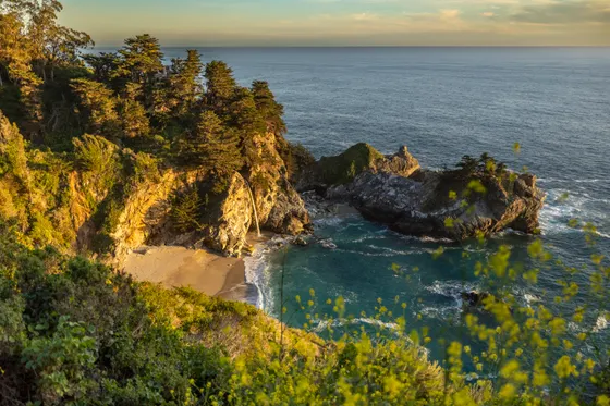
South coast finale · McWay Falls & the Ewoldsen Trail
Drive south to Julia Pfeiffer Burns State Park for the signature image of Big Sur. The short McWay Falls Overlook trail (about 0.6 miles round trip) leads to a bluff above an 80-foot waterfall that drops straight onto a cove beach, one of the most photographed scenes on the entire California coast. Just north, the easy Partington Cove trail (about 1 mile) drops through a rock tunnel to a tiny historic cove.
For the best hiking-trail day in the park, walk the Ewoldsen Trail (about 4.5 miles), a redwood-canyon-to-coast loop with big ocean views up high. Note: portions of the Ewoldsen Trail have been closed for storm and fire damage in recent years, so confirm it is open before you count on it, and have Partington Cove or the McWay overlook as a backup. Heading north? On the way back toward Monterey, add a Monterey Bay kayak or SUP paddle with Adventures by the Sea on Cannery Row.
- Guided Monterey Bay paddle on Cannery Row · ~25 mi north · add on the way in or out
- ~0.6 mi RT · easy · iconic 80-ft waterfall onto the beach
- ~4.5 mi · redwoods + coast · may be partially closed, confirm first
- ~1 mi · easy · rock tunnel down to a historic cove · good backup
- The McWay Falls overlook is a short, easy walk and the beach below is closed to access, so the photo from the bluff is the experience. Go early or late to avoid the busiest parking.
- Portions of the Ewoldsen Trail have closed for storm and fire damage in recent years. Confirm it is open before you rely on it, and keep Partington Cove and the McWay overlook as backups.
- Monterey sits about 25 miles north of Big Sur proper, so a Monterey Bay kayak or SUP paddle works best as an add-on on the way in or out, not a Big Sur day trip in itself.
 Partington Cove
 Highway 1
Now build your Big Sur trip.
You've seen all three days. Open the free drag-and-drop planner and tune it for your dates, your pace, and whether you base in Big Sur, Carmel-by-the-Sea, or Monterey.
What we actually learned on the coast.
Check Caltrans before you drive
Highway 1 (CA-1) is the only road through Big Sur, and it periodically closes for landslides, sometimes for months at a time. Always check Caltrans for current CA-1 conditions before you set out, because a closure can mean a long detour or a dead end.
Fill up and download maps first
Gas stations are few and far between in Big Sur, and what little fuel exists is pricey. Fill up in Carmel or Monterey before you head south, download offline maps, and do not count on cell service along most of the coast.
Expect a day-use fee at the parks
Most Big Sur state-park trailheads (Pfeiffer Big Sur, Julia Pfeiffer Burns, Andrew Molera, Garrapata) charge a day-use fee, typically around $10 per vehicle. A single day pass often covers more than one state park on the same day.
Plan around the coastal fog
Marine fog is common and mornings are frequently socked in, especially in summer. It often burns off by midday, so save coastal overlooks like McWay Falls for the afternoon and do redwood hikes early when the canyon is at its best.
Book lodging far ahead
Lodging in Big Sur proper is limited and expensive, and Big Sur Lodge, Ventana, and Post Ranch Inn all book months ahead. If they are full or over budget, base in Carmel-by-the-Sea or Monterey and drive in for the day.
Confirm trail closures
Big Sur trails take a beating from storms and wildfire, and some sections of trails like the Ewoldsen close for long stretches. Confirm your planned hikes are open with the state parks before you go, and keep an easy backup like the McWay overlook in your pocket.
Grab the photo turnouts early
The turnouts at Bixby Creek Bridge, and the small lots at Pfeiffer Beach and McWay Falls, hold only a handful of cars and get stressful, even dangerous, by midday. Aim to be at Bixby around 8 AM, hit the coastal viewpoints early or near sunset, and never stop on the bridge deck itself.
Everything you'll actually want to know.
Ready to go? Get your
Big Sur hiking route.
Trailheads and mileages, the limited Big Sur lodging plus Carmel and Monterey fallbacks, day-use fees, the Caltrans closure check, fog timing, and a Monterey Bay paddle add-on for the way in or out.
Instant book · Free cancellation · Secure payment via Stripe
Know these trails yourself? Become a local guide and host free community hikes.


Planning this trip?
Save it, share it with your crew, or find travelers heading the same way.
What other travelers are saying
Be the first to leave a tip or question for the next traveler.
How was your experience?
Tell us what worked and what did not. It goes straight to Yulia and Margarita.