
California National Parks Family Loop:
A 10-Day Itinerary
A 10-day California national parks road trip built for families: Yosemite Valley waterfalls, Glacier Point, the giant sequoias of Mariposa Grove, then the General Sherman Tree and Moro Rock in Sequoia & Kings Canyon.
Free interactive planner · drag & reorder your days, add stops, map it in minutes
Build your own California parks trip, drag, reorder & map it.
Drag stops between days, swap easy hikes for harder ones, and add your own waterfalls and overlooks with the place search. The live map and drive times recalculate as you go, so you can see exactly how long those mountain transfers really take with kids in the car.
Opens a side panel · reorder days, add custom stops, see your route live
Three giant parks, waterfalls & big trees, built for families.
This California national parks road trip strings together the heavyweights of the Sierra Nevada over ten days: Yosemite, with its waterfalls and granite walls, and Sequoia & Kings Canyon, home to the largest trees on Earth. It is paced for families, leaning on easy valley-floor walks, free shuttle buses, junior ranger programs, and plenty of picnic stops between the big sights.
In Yosemite you'll do the Valley floor, Lower Yosemite Fall, Bridalveil Fall, and Mirror Lake, take in the jaw-dropping Glacier Point view, and walk among the ancient giant sequoias of Mariposa Grove. Then you'll cross to Sequoia & Kings Canyon for the General Sherman Tree, the granite dome of Moro Rock, the kid-friendly Big Trees Trail, and a tour of Crystal Cave.
Late spring through early fall is the window. Yosemite's waterfalls peak in May and June on snowmelt, while Tioga Road over the high country stays closed by snow until late spring. Summer brings the biggest crowds, so book in-park lodging up to a year ahead or stay in the gateway towns of Mariposa, Oakhurst, or Three Rivers, and expect a peak-season reservation may be required to enter Yosemite, so check nps.gov before you go.
In-park lodging in Yosemite Valley and at Sequoia & Kings Canyon books up to a year in advance for summer, so reserve early or stay in the gateway towns of Mariposa, Oakhurst, or Three Rivers. Yosemite has used a peak-season day-use reservation system in recent summers, so check nps.gov before your dates. This is bear country, so use the food lockers at lodgings and trailheads and never leave food in your car.


Fly in & drive to Yosemite · the Valley floor
Fly into Fresno (FAT) for the shortest drive, or into Sacramento or San Francisco for cheaper flights and a bigger road trip. From Fresno it is roughly 2.5 to 3 hours up to Yosemite Valley; from the Bay Area plan on around 4 hours. Pick up groceries and picnic supplies before you climb into the mountains, because options thin out fast.
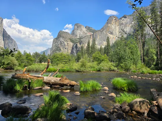
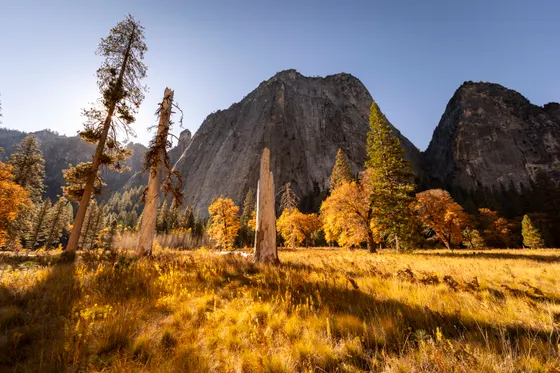
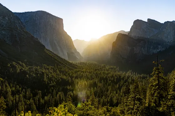
Roll into Yosemite Valley in the afternoon and just let the kids take in the scale of it: El Capitan, Half Dome, and the granite walls towering thousands of feet overhead. Park the car and ride the free Valley shuttle, walk a flat stretch of the loop trail, and find a picnic spot by the Merced River to settle in before your first night.
- Drive to Yosemite ValleyFAT ~2.5–3 hr · SFO ~4 hr · stock up on groceries first
- Free hop-on shuttle loops the Valley · skip the parking hunt
- Merced River picnicFlat riverside spots under El Capitan and Half Dome
- Stay in Yosemite ValleyIn-park lodges book a year ahead · or base in Mariposa
- A peak-season day-use reservation may be required to drive into Yosemite in summer. Check nps.gov for your dates before you go.
- In-park lodging in Yosemite Valley books up to a year in advance for summer. If it is full, base in Mariposa or Oakhurst and drive in.
- This is bear country. Use the food lockers at your lodging and trailheads, and never leave snacks or coolers in your car.

Yosemite waterfalls · Lower Yosemite Fall & Bridalveil
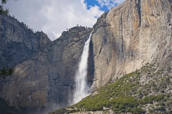
Spend today chasing the waterfalls that make Yosemite famous, on trails short enough for little legs. Walk to Lower Yosemite Fall (about 1 mile round trip, easy and mostly paved), where in spring you can feel the spray off the base of North America's tallest waterfall. It is one of the best easy walks in the park and a guaranteed kid pleaser when the snowmelt is roaring.
Then drive to the west end of the Valley for Bridalveil Fall (about 0.5 mile round trip, easy), a quick paved walk to a 620-foot ribbon of water that often catches a rainbow in the mist. Remember the waterfalls peak in May and June and can slow to a trickle by late summer, so plan your timing around the snowmelt if waterfalls are the goal.
- ~1 mi RT · easy · mostly paved · feel the spray in spring
- ~0.5 mi RT · easy · paved · 620-ft fall with rainbows
- Pick up a booklet at the visitor center · earn a badge
- Second night in Yosemite ValleyStay put so the kids can pace the Valley over two days
- Yosemite's waterfalls run on snowmelt and peak in May and June. By late summer some slow to a trickle, so time your visit if waterfalls are the goal.
- Both Lower Yosemite Fall and Bridalveil Fall are short, mostly paved walks, ideal for younger kids and strollers on the smoother sections.
- Pick up a Junior Ranger booklet at the visitor center on your first morning so the kids can work on it across the whole trip.
Mirror Lake & a slow Valley day
Take the pressure off with an easier day deeper in the Valley. The walk to Mirror Lake (about 2 miles round trip on the paved route, easy) leads to a seasonal pool that reflects Half Dome when the water is high in spring and early summer. By late summer it often dries to a meadow, but the wide, flat path and the river make it a relaxed family outing either way.
Round out the day with the things that make Yosemite click for kids: a stop at the visitor center, the junior ranger activities, a swim or a wade in the Merced River on a warm afternoon, and an easy bike ride on the Valley's paved bike paths. This is the day to slow down, picnic, and let everyone recharge before tomorrow's big view.
- ~2 mi RT paved · easy · Half Dome reflections in spring
- Merced River wade or swimCalm, sandy spots in summer · check current and depth
- Flat paved bike loop · rentals available in the Valley
- Third night in Yosemite ValleyLast Valley night before Glacier Point and Mariposa Grove
- Mirror Lake is fullest in spring and early summer and often dries to a meadow by late summer. The walk is pleasant either way.
- Renting bikes for the flat Valley bike paths is one of the easiest ways to cover ground with kids without the car.
- If you swim or wade in the Merced River, pick calm, shallow spots and watch the current, which runs cold and fast during peak snowmelt.
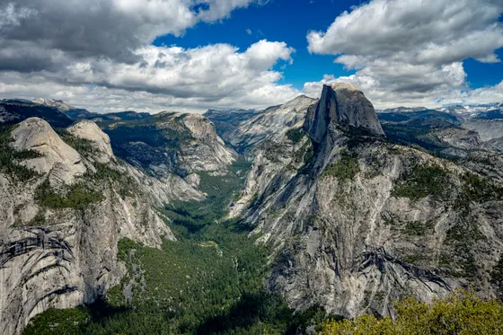
Glacier Point · the classic Yosemite view
Drive up out of the Valley to Glacier Point, the single most jaw-dropping overlook in Yosemite. From the railing 3,200 feet above the Valley floor, the whole scene lays out at once: Half Dome face-on, Yosemite Falls across the way, and the high country rolling off into the distance. The viewpoint is a short, accessible walk from the parking area, so the payoff per step is huge for families.
Glacier Point Road opens once the snow clears, typically by late spring, so check that it is open before you commit the day. Pack a picnic and time it for late afternoon if you can, when the light warms the granite. For a little more, the short Sentinel Dome or Taft Point trails nearby reward bigger kids with even wider views.
- Short accessible walk · Half Dome and Yosemite Falls in one view
- Drive Glacier Point RoadOpens once snow clears, typically late spring · check status
- Short trails near Glacier Point · big views for older kids
- Move base toward Wawona or OakhurstPosition for Mariposa Grove tomorrow · or stay another Valley night
- Glacier Point Road is closed by snow in winter and opens once it clears, usually by late spring. Confirm it is open on nps.gov before you drive up.
- The Glacier Point viewpoint is a short, mostly accessible walk from the lot, so even young kids can reach the famous overlook easily.
- Bring a picnic and aim for late afternoon, when the light warms the granite and the midday crowds start to thin.
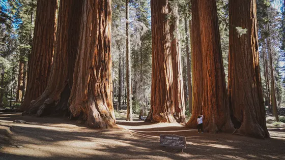
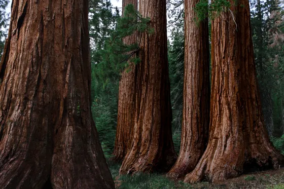
Mariposa Grove · the giant sequoias of Yosemite
Head to the south end of the park for Mariposa Grove, Yosemite's largest stand of giant sequoias and a highlight kids never forget. A free shuttle runs from the welcome plaza to the grove in season, and the Big Trees Loop (about 0.3 mile, easy and accessible) puts you among towering ancient trees within minutes of stepping off the bus.
For more, the Grizzly Giant Loop (about 2 miles round trip, easy to moderate) reaches the Grizzly Giant, one of the oldest and largest sequoias in the grove, and the famous California Tunnel Tree. This is the perfect day to lean on the junior ranger booklet and to talk about how these trees have stood for two thousand years or more. Then base near Mariposa or Oakhurst for the night.
- ~0.3 mi · easy · accessible boardwalk among giant sequoias
- ~2 mi RT · easy to moderate · Grizzly Giant & Tunnel Tree
- Free seasonal shuttle from the welcome plaza to the grove
- Stay in Mariposa or OakhurstGateway towns with family lodging · stock up before tomorrow
- A free shuttle usually runs from the Mariposa Grove welcome plaza into the grove in season. Check nps.gov, as private cars are often restricted.
- The Big Trees Loop is a short accessible boardwalk, so even the youngest kids and strollers can get among the giant sequoias.
- Mariposa Grove sits at the south end of Yosemite, so basing in Oakhurst or Mariposa tonight sets you up for the drive to Sequoia tomorrow.
Drive south to Sequoia & Kings Canyon
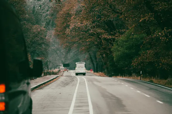
Today is a transfer day, so settle in for one of the trip's longer mountain drives. From the Oakhurst area down to the Three Rivers gateway and the Sequoia entrance is roughly 2.5 to 3 hours, much of it on winding two-lane roads. Inside the park, the climb up the Generals Highway from the foothills to the giant forest is steep and slow, with tight switchbacks, so allow extra time and let everyone settle their stomachs.
Break up the drive with stops and snacks, and aim to reach the Giant Forest area in the afternoon. Get the lay of the land at the Giant Forest Museum, then save your energy: tomorrow is the big-tree day. Base in Three Rivers just outside the park, or in-park if you booked a lodge well ahead.
- Drive to Sequoia & Kings CanyonOakhurst to Three Rivers ~2.5–3 hr · winding mountain roads
- Climb the Generals HighwaySteep switchbacks to the Giant Forest · go slow, allow time
- Orient the kids before the big-tree day · easy stop
- Stay in Three RiversGateway town just outside the Sequoia entrance · family lodging
- The Generals Highway climbs steeply with tight switchbacks. Drive slowly, use low gears on the descents, and pack motion-sickness remedies for kids.
- Vehicle length is restricted on parts of the road between the foothills and Giant Forest. Check the limits on nps.gov if you are driving an RV or towing.
- Three Rivers, just outside the entrance, has the most family lodging. In-park lodges are limited and book far ahead for summer.
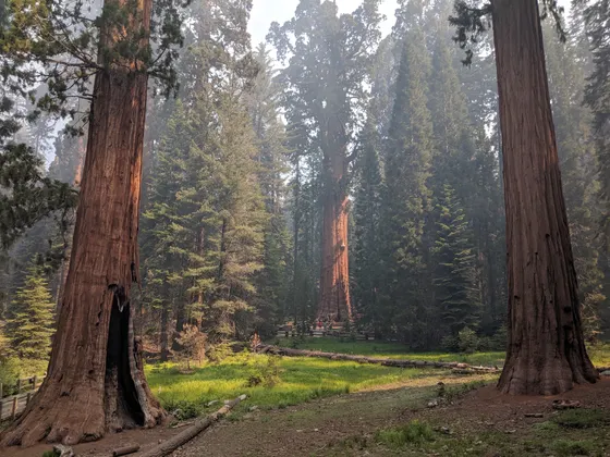
The General Sherman Tree & Big Trees Trail
This is the day the kids have been waiting for. A paved path leads down to the General Sherman Tree, the largest living tree on Earth by volume, standing 275 feet tall with a base wider than a city street. The walk down from the upper lot is about 1 mile round trip and the return climb is uphill at altitude, so take it slow, and use the accessible lot if anyone needs the easier approach.
Pair it with the Big Trees Trail (about 1.2 miles, easy and accessible), a flat loop around a meadow ringed by giant sequoias with interpretive signs perfect for junior rangers. Together these two short trails deliver the heart of Sequoia National Park without a hard hike, and there are picnic spots in the Giant Forest to make a relaxed afternoon of it.
- ~1 mi RT paved · the largest tree on Earth · uphill return
- ~1.2 mi · easy · accessible meadow loop · junior ranger signs
- Sequoia has its own booklet and badge · ask at a visitor center
- Stay near the Giant Forest or Three RiversIn-park lodge if booked ahead, or back down to Three Rivers
- The walk to the General Sherman Tree is downhill on the way in and uphill on the way back, at around 7,000 feet. Take it slow and carry water.
- There is an accessible parking area closer to the tree for anyone who cannot manage the main trail. Look for the signed lot off the Generals Highway.
- The Big Trees Trail is a flat, accessible loop with great interpretive signs, ideal for finishing a Junior Ranger booklet.

Moro Rock & Crystal Cave
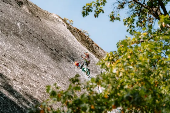
Climb the granite dome of Moro Rock by way of its famous staircase, about 400 steps cut and built into the rock that lead to a railed summit with a sweeping view over the Great Western Divide and the foothills far below. It is short, around half a mile round trip, but it is a real stair climb at altitude with steep drop-offs, so keep little ones close and skip it if anyone is afraid of heights.
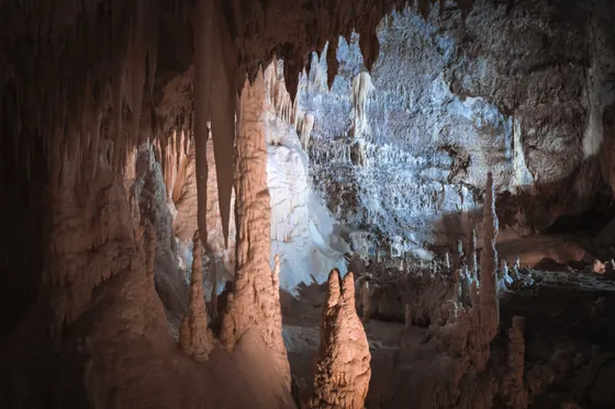
In the afternoon, drop underground on a guided tour of Crystal Cave, a marble cavern of formations that stays cool on a hot day and fascinates kids. Tours are by timed ticket only and often sell out, and they are not sold at the cave, so buy them in advance online. Note the cave can close some seasons for maintenance or road repairs, so confirm it is open and ticketed before you build your day around it.
- ~0.5 mi RT · ~400 stairs · railed summit · steep drop-offs
- Guided marble cavern · timed tickets · buy ahead online
- Easy flat meadow loop · "the gem of the Sierra" · picnic spot
- Last Sequoia nightStay near the Giant Forest or in Three Rivers
- Crystal Cave tours are by timed ticket only, sell out, and are not sold at the cave. Buy them in advance online, and confirm the cave is open that season.
- Moro Rock is a short but steep stairway climb with big drop-offs and railings. Hold young kids' hands and turn back if anyone is uneasy with heights.
- In summer a shuttle often serves Moro Rock and Crescent Meadow because parking is tiny. Check whether you need to ride it instead of driving in.
Kings Canyon · Grant Grove & the canyon drive
Cross into the Kings Canyon side of the park, starting at Grant Grove and the General Grant Tree, the nation's Christmas Tree and the second largest tree in the world, reached on a short, easy paved loop about 0.5 mile long. It is an easy companion to General Sherman and another effortless win with kids.
If everyone has the appetite for one more drive, the Kings Canyon Scenic Byway (Highway 180) drops dramatically into one of the deepest canyons in North America, with overlooks, the roadside Roaring River Falls, and the green meadows of Cedar Grove at the bottom. It is a long out-and-back, so make it the day's adventure or keep it mellow at Grant Grove. The byway is seasonal and closed in winter, so check it is open.
- ~0.5 mi · easy paved loop · the nation's Christmas Tree
- Hwy 180 into a deep canyon · overlooks · seasonal, closed winter
- Short paved walk to a roadside waterfall · easy leg-stretcher
- Stay in Grant Grove or Three RiversLast park night · or start positioning for the airport
- The Kings Canyon Scenic Byway (Highway 180) is closed in winter and opens seasonally. Confirm it is open on nps.gov before planning the canyon drive.
- The General Grant Tree Trail is a short, easy paved loop, a perfect lower-effort companion to the General Sherman walk.
- The drive to the bottom of Kings Canyon and back is long. If the kids are tired, keep the day at Grant Grove and save the canyon for next time.

Drive out & fly home
Wrap up with an easy morning and the drive back to the airport. From Three Rivers it is roughly 1.5 hours down to Fresno (FAT), or about 4 hours to Sacramento or San Francisco if you flew into the Bay Area for a bigger loop. Build in buffer for the slow mountain roads on the way out, and plan around the kids' patience for the final leg.
If you have time before your flight, the foothills section of the park near the Sequoia entrance is warm and green in spring and makes a nice last stop, or you can simply roll out early and beat the traffic. Getting home: top off your gas in Three Rivers or on the way down, since options thin out in the mountains, and leave with margin for any holiday or weekend backups on Highway 99.
- Drive to the airportThree Rivers to FAT ~1.5 hr · SFO or Sacramento ~4 hr
- Warm green foothills near the entrance · an easy final stroll
- Fuel up before the drive outTop off in Three Rivers · gas thins out in the mountains
- Fresno (FAT) is the closest airport for both parks. Sacramento and San Francisco are cheaper to fly into but turn the trip into a much bigger driving loop.
- Allow extra time for the winding descent out of the mountains, especially with kids who get carsick or on busy summer weekends.
- Fill up on gas in Three Rivers or down in the valley before you leave, since stations are sparse in and around the parks.
Now build your California parks trip.
You've seen all ten days. Open the free drag-and-drop planner and tune it for your dates, your kids' pace, and whether you base in Yosemite Valley, Mariposa, Oakhurst, or Three Rivers.
What we actually learned with kids in the Sierra.
Pay each park fee or bring your pass
Yosemite and Sequoia & Kings Canyon each charge about $35 per vehicle for a 7-day pass. The annual America the Beautiful pass ($80) covers entry to both and every other national park, so it pays off fast on a multi-park loop like this one. Buy it at the gate or online ahead.
Reservations may be required for Yosemite
Yosemite has used a peak-season day-use reservation system in recent summers, and Mariposa Grove and other areas run shuttles with their own rules. Check nps.gov for your exact dates before you go, and book any required entry reservation as soon as the window opens.
Book lodging up to a year ahead
In-park lodges in Yosemite Valley and at Sequoia & Kings Canyon sell out up to a year in advance for summer. If they are full, base in the gateway towns of Mariposa, Oakhurst, or Three Rivers and drive in, which is what most families end up doing.
This is bear country, so use the lockers
Black bears are active across all three parks. Use the metal food lockers at lodgings and trailheads, never leave food, coolers, or even scented items in your car, and keep a clean campsite. A bear breaking into a car for snacks is a real and common problem here.
Mountain drives are long and winding
These parks look close on a map but the transfers are long, slow, and twisty, especially the Generals Highway and the road between Yosemite and Sequoia. Allow far more time than the mileage suggests, pack motion-sickness remedies, and build in snack and bathroom stops.
Go late spring to early fall
The sweet spot is May through September. Yosemite's waterfalls peak on snowmelt in May and June, while Tioga Road over the high country stays closed by snow until late spring. Summer is busiest, so start early each day to beat crowds and parking crunches.
Everything you'll actually want to know.
Ready to go? Get your
California parks family route.
Easy trails and mileages, the free shuttles, junior ranger programs, picnic stops, gateway-town lodging in Mariposa, Oakhurst and Three Rivers, the mountain drive times, and the reservation and bear rules you need to do this loop with kids.
Instant book · Free cancellation · Secure payment via Stripe


Planning this trip?
Save it, share it with your crew, or find travelers heading the same way.

Liked this itinerary?
What other travelers are saying
Be the first to leave a tip or question for the next traveler.