
Seven Days, Five Parks:
The Utah Southwest Loop
A 7-day national park road trip through Utah: Arches and Canyonlands out of Moab, the Colorado River, then Capitol Reef, Bryce Canyon, and Zion as you loop west.
Free interactive planner · drag & reorder your days, add stops, map it in minutes
Build your own national park road trip, drag, reorder & map it.
Drag parks and stops between days, add your own overlooks and trailheads with the place search, and reorder the loop to start from Salt Lake City, Las Vegas, or Moab. The live map and drive times recalculate as you go, and we'll warn you before you build a day no one survives in the desert heat.
Opens a side panel · reorder days, add custom stops, see your route live
One loop, five national parks, across red rock Utah.
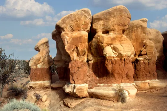
This is the most iconic national park road trip in the country: Utah's Mighty 5 plus Moab, a red rock loop that strings together Arches, Canyonlands, Capitol Reef, Bryce Canyon, and Zion across some of the most dramatic desert landscapes on earth. You start in Moab, the adventure hub of the Colorado Plateau, and loop west, trading delicate arches and canyon overlooks for hoodoos and slot canyons as you go.
This 7-day national parks road trip itinerary is built around big scenery and manageable drives: Delicate Arch and the Windows in Arches, Mesa Arch at sunrise and Grand View Point in Canyonlands, a day on the Colorado River in Moab, then Capitol Reef's orchards and scenic drive, Bryce Canyon's hoodoo amphitheater, and Zion's towering walls to finish. Gas up between parks, because the stretches in between are long and empty.
Spring and fall are the prime seasons, with comfortable days and cool nights. Summer is dangerous on the desert trails: temperatures regularly top 100°F, so carry plenty of water, start hikes at dawn, and save midday for the air-conditioned drives between parks. Winter is quiet and beautiful but brings snow and icy trails at Bryce's higher elevations.
In peak season (often spring through fall) Arches National Park requires a timed-entry reservation to drive in during daytime hours, booked in advance on recreation.gov, so grab one the moment your dates are set. Moab lodging fills fast on weekends, and there is no gas inside the parks, so fill up in Moab, Torrey, and the gateway towns before every long desert stretch.


Arrive in Moab & first light in Arches
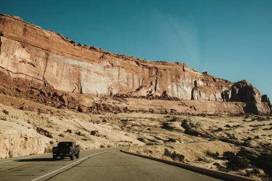
Fly into Salt Lake City (SLC) and make the roughly 3.5- to 4-hour drive south to Moab, or shorten the trip by flying into Moab (CNY) or Grand Junction (GJT) just across the Colorado line. Moab is the basecamp for this whole leg, a red rock adventure town wedged between Arches and Canyonlands on the banks of the Colorado River.
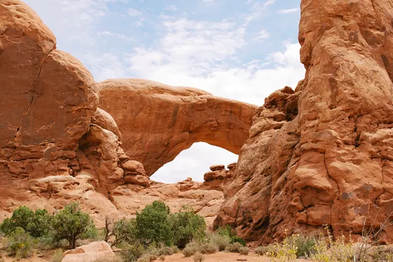
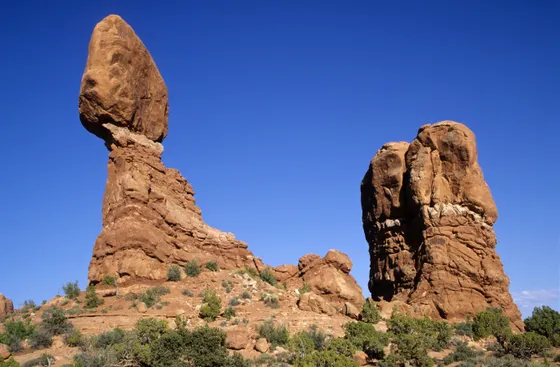
Spend your first evening in Arches National Park, where over 2,000 natural stone arches sit just minutes from town. In peak season you'll need a timed-entry reservation to drive in during the day, booked ahead on recreation.gov, but early mornings and evenings often fall outside the window. Start with The Windows section and Balanced Rock for an easy first taste, then watch the light go gold on the fins.
- Over 2,000 arches · timed-entry reservation needed in peak season
- The Windows & Balanced RockShort, easy walks · big arches up close · great first evening
- Fuel up & stock water in MoabNo gas in the parks · carry plenty of water before you head in
- Base in MoabAdventure hub between Arches and Canyonlands · books up fast
- In peak season Arches requires a timed-entry reservation to drive in during daytime hours. Book it on recreation.gov as soon as your dates are set, or plan early-morning and evening visits that fall outside the window.
- Moab is the only real supply town for this leg. Fill the gas tank and stock plenty of water before heading into either park, because there is none inside.
- The Windows and Balanced Rock are short, easy walks that make a perfect first evening while the light is soft on the red rock.
Arches in depth · Delicate Arch & Devils Garden
Spend a full day in Arches. The signature hike is to Delicate Arch (about 3 miles round trip, moderate, no shade), the freestanding arch on Utah's license plate. The climb up the slickrock is exposed and hot, so go at sunrise or in the late afternoon and carry plenty of water. Sunset at the arch is one of the great experiences in the park, but the lot fills early.
In the cooler part of the day, explore the Devils Garden at the end of the scenic road, home to Landscape Arch and a network of trails through the fins. With less time, drive the main park road and hit the major pullouts. Either way, start early: by midday the desert heat and the crowds both peak.
- ~3 mi RT · moderate · no shade · sunrise or sunset
- Trail network through the fins · Landscape Arch is an easy walk
- Carry plenty of waterNo water and little shade on the trails · start at first light
- Second night in MoabStay put so you can hit the trailheads at dawn
- The Delicate Arch Trail is about 3 miles round trip with no shade and an exposed slickrock climb. Hike it at sunrise or late afternoon and carry at least two liters of water per person.
- Sunset at Delicate Arch is spectacular, but the trailhead lot fills well before golden hour, so arrive early or hike it in the morning instead.
- Save the Devils Garden and the longer fins trails for the cooler morning hours. By midday the desert heat is serious.
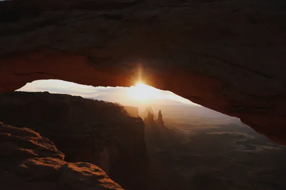
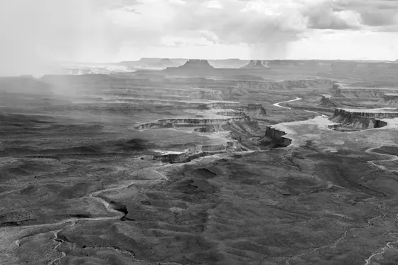
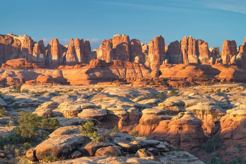
Canyonlands · Mesa Arch sunrise & Island in the Sky
Wake before dawn and drive about 40 minutes to the Island in the Sky district of Canyonlands National Park, a high mesa that floats above a vast maze of canyons carved by the Colorado and Green Rivers. The classic photographer's stop is Mesa Arch at sunrise (about a 0.5-mile round-trip walk), where the rising sun lights the underside of the arch in fiery orange over the canyon below.
Spend the morning chasing overlooks along the mesa rim: Grand View Point at the end of the road has the biggest panorama in the park, with the canyons dropping away in every direction. Add the short walk to Green River Overlook and, if you want a longer leg, the trail out to Upheaval Dome. Then drive back toward Moab in the heat of the day.
- Island in the Sky district · overlooks above the canyon maze
- Mesa Arch at sunrise~0.5 mi RT · the arch glows orange at first light · arrive early
- Grand View PointEnd-of-road panorama · the biggest view in the park
- Third night in MoabLast night before the loop west to Capitol Reef
- Mesa Arch faces east and lights up at sunrise, drawing a crowd of photographers. Arrive 30 to 45 minutes before first light to claim a spot at the railing.
- Island in the Sky has no water and no gas, so fill up and stock water in Moab before the 40-minute drive up to the mesa.
- Grand View Point at the end of the road has the biggest panorama in the park and a flat rim trail. Save it for after the Mesa Arch sunrise crowd thins out.
Moab · the Colorado River & mountain biking

Slow down for a day in Moab, the adventure capital of the Colorado Plateau. The town sits on the Colorado River, and the best way to feel the scale of the canyons is from the water. Book a guided raft or kayak trip with Wild West Voyages for a half-day float between red rock walls, an easy, scenic way to cool off in the desert heat.
Moab is also one of the world's great mountain biking destinations, from the legendary slickrock to mellow riverside paths, with outfitters in town renting bikes and running shuttles. Prefer to stay on four wheels? Drive the Colorado River scenic byway (Highway 128) northeast out of town, a stunning stretch of pavement that hugs the river beneath towering canyon walls. Tonight is your last night in Moab before the loop west.
- Guided Moab river trip · cool off between the red rock walls · book ahead
- Mountain biking in MoabWorld-famous slickrock to mellow riverside trails · rentals in town
- Colorado River scenic byway (Hwy 128)River-hugging drive northeast of town beneath canyon walls
- Last night in MoabFuel up and stock water before the drive to Capitol Reef
- Wild West Voyages runs guided raft and kayak trips on the Colorado River right out of Moab. Reserve ahead, especially on weekends, and aim for a morning slot before the desert heat peaks.
- Moab is a world-class mountain biking town. If the legendary slickrock is too much, the paved riverside paths and gentler trails are an easy way to ride the desert.
- Fill your gas tank and restock water before you leave Moab. The drive west to Capitol Reef crosses long, empty desert with few services.
Capitol Reef · the Waterpocket Fold & scenic drive
Leave Moab and drive west about 2.5 hours to Capitol Reef National Park, the quietest and most underrated of Utah's Mighty 5. The park protects the Waterpocket Fold, a 100-mile wrinkle in the earth's crust, along with the green historic orchards of Fruita, where in season you can pick apples, pears, and peaches in the shadow of red cliffs.
Drive the Capitol Reef Scenic Drive south past towering canyon walls, then walk into the Capitol Gorge or hike up to Hickman Bridge (about 1.8 miles round trip), a natural bridge above the Fremont River. Base for the night in Torrey, the small gateway town just west of the park, before the drive to Bryce.
- Drive Moab to Capitol Reef~2.5 hr west · long, empty desert · fuel up before you go
- Capitol Reef Scenic Drive & Fruita orchardsTowering walls · historic orchards · pick fruit in season
- Hickman Bridge Trail~1.8 mi RT · natural bridge above the Fremont River
- Stay in TorreyGateway town just west of the park · base before Bryce
- The drive from Moab to Capitol Reef is about 2.5 hours across open desert with few services. Fill up and grab snacks and water in Moab before you set out.
- Capitol Reef is the least crowded of Utah's Mighty 5. The Fruita orchards are a highlight, and in season you can pick fruit for a small fee.
- Hickman Bridge is an easy, rewarding 1.8-mile hike to a natural bridge. Like everywhere on this trip, hike it early before the midday heat.
Bryce Canyon · the hoodoo amphitheater
Drive about 2.5 hours southwest to Bryce Canyon National Park, where thousands of orange-and-pink stone spires called hoodoos fill a series of natural amphitheaters carved into the edge of a high plateau. At over 8,000 feet, Bryce is much cooler than the desert parks, so pack a layer even in summer.
Walk the rim between Sunrise Point and Sunset Point for the classic overview, then drop down into the hoodoos on the Queens Garden and Navajo Loop (about 3 miles combined), widely rated the best short hike in the park. Catch sunrise or sunset on the rim, when low light sets the whole amphitheater glowing, before settling in near the park for the night.
- Drive Capitol Reef to Bryce Canyon~2.5 hr southwest · climbs to over 8,000 ft · pack a layer
- Sunrise & Sunset Point rim walkClassic amphitheater overview · best at sunrise or sunset
- Queens Garden & Navajo Loop~3 mi combined · the best short hike down into the hoodoos
- Stay near Bryce CanyonBryce Canyon City or nearby · cooler nights at altitude
- Bryce sits above 8,000 feet, so it is far cooler than the desert parks and can be cold at dawn. Pack a warm layer even in summer for sunrise on the rim.
- The combined Queens Garden and Navajo Loop is about 3 miles and the best way to walk among the hoodoos. Go down Queens Garden and up the Navajo switchbacks.
- Sunrise and Sunset Points are both stunning at their namesake hours. Low-angle light is what makes the orange hoodoos glow, so plan around it.
Zion · towering walls & the drive home
Finish big at Zion National Park, about 1.5 hours southwest of Bryce, where the road plunges into a deep canyon between 2,000-foot sandstone walls. Most of Zion Canyon is car-free, so park and ride the shuttle up the canyon, hopping off at the overlooks, the Emerald Pools, and the Riverside Walk to the mouth of the Narrows.
With energy and a head for heights, the classic Zion adventures are the Narrows, a wade up the Virgin River between soaring walls, and Angels Landing, a chain-assisted scramble that requires a permit booked ahead on recreation.gov. Base in Springdale right outside the gate. Getting home: Las Vegas (LAS) is about 2.5 to 3 hours southwest and Salt Lake City (SLC) about 4.5 hours north, so fuel up and start the drive with daylight to spare.
- Zion Canyon shuttle & overlooksCar-free canyon · hop-off at Emerald Pools and the Riverside Walk
- The NarrowsWade up the Virgin River between soaring walls · check flows first
- Angels LandingChain-assisted scramble · permit required via recreation.gov
- Getting home: Las Vegas or Salt Lake CityLAS ~2.5–3 hr · SLC ~4.5 hr · fuel up before the drive out
- Most of Zion Canyon is closed to cars in the busy season, so park in Springdale or at the visitor center and ride the free shuttle up the canyon.
- Angels Landing requires a permit obtained ahead of time through a lottery on recreation.gov. The Narrows needs no permit but does require checking the Virgin River flow and weather for flash flood risk.
- It is a long drive to the airport from Zion. Las Vegas is about 2.5 to 3 hours and Salt Lake City about 4.5 hours, so fuel up in Springdale and leave with daylight to spare.
Now build your national park road trip.
You've seen all seven days. Open the free drag-and-drop planner and tune it for your dates, your pace, and whether you fly into Salt Lake City, Las Vegas, or Moab.
What we actually learned on the road.
Get the America the Beautiful pass
This road trip hits five national parks, so skip per-park fees and buy the annual America the Beautiful pass ($80). It covers entry to all of them and pays off after just three parks. Buy it at the first entrance station or online ahead of time.
Reserve Arches timed entry early
In peak season Arches National Park requires a timed-entry reservation to drive in during daytime hours, released in advance on recreation.gov. Book it the moment your dates are set, or plan early-morning and evening visits that fall outside the reservation window.
Gas up between every park
There is no gas inside the national parks and the stretches between them are long and empty. Fill up in Moab, Torrey, Bryce Canyon City, and Springdale, and top off whenever you pass a station so you are never caught short in the desert.
Carry far more water than you think
The desert trails are exposed and brutally dry. Carry at least two to three liters of water per person per day, and more on exposed hikes like Delicate Arch. There is no water on most trails, and heat is the number one danger out here.
Go in spring or fall, hike at dawn
Spring and fall bring comfortable days and cool nights, the best time for this trip. Summer is dangerous on the desert trails, with temperatures over 100°F, so hike at dawn and use the midday heat for the long drives between parks. Bryce stays cool year-round at altitude.
Book lodging in the gateway towns early
Moab, Torrey, Bryce Canyon City, and Springdale all fill fast in peak season, especially on weekends. Book your stays as soon as your dates are firm, and reserve any in-park campgrounds through recreation.gov well in advance.
Everything you'll actually want to know.
Ready to go? Get your
national park road trip route.
Park order and drive times, the Arches timed-entry catch, gas and water stops, the Moab river outfitter, gateway-town lodging, and the dawn-hike timing you need to road-trip the Southwest safely.
Instant book · Free cancellation · Secure payment via Stripe


Planning this trip?
Save it, share it with your crew, or find travelers heading the same way.

Liked this itinerary?
What other travelers are saying
Be the first to leave a tip or question for the next traveler.