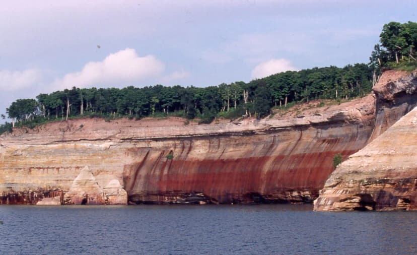
Pictured Rocks National Lakeshore stretches roughly 42 miles along Lake Superior between Munising and Grand Marais in Michigan's Upper Peninsula. The cliffs glow in shades of orange, green, and rust where mineral-stained water seeps over the sandstone, and the only way to truly see them is on foot or from the water. This guide walks through the best hikes, from short cliff-top overlooks to one of the finest day hikes in the Midwest.
Chapel Loop: The Signature Day Hike
If you do one hike here, make it the Chapel Loop. The full loop runs about 10 miles and links Chapel Falls, Chapel Beach, Chapel Rock with its famous lone pine tree, and a stretch of the cliff-top Lakeshore Trail past Grand Portal Point. It is moderate but long, so carry water and start early. The trailhead sits at the end of a gravel county road off H-58 east of Munising; the last few miles are washboard, so allow extra driving time.
For a shorter taste, hike the 1.4 miles out to Chapel Falls and turn back, or do an out-and-back to Chapel Beach for the classic view of Chapel Rock perched on its sea stack.
Miners Castle and Miners Falls
The most accessible iconic view is Miners Castle, a turreted rock formation reachable by a paved path just steps from the parking lot. A staircase drops to a lower platform right above the water. Nearby, a flat 1.2-mile round-trip leads to Miners Falls, a powerful 40-foot drop tucked in the forest. Both are ideal for families or for a quick stop if you are passing through.
Mosquito Falls and Mosquito Beach
From the Chapel area you can also reach Mosquito Falls and a string of small cascades along the Mosquito River, ending at a beach with a rare stretch of flat sandstone shelf you can walk out on. Combining Mosquito and Chapel makes a long but rewarding figure-eight for strong hikers.
The North Country Trail and Lakeshore Trail
The full Lakeshore Trail runs the length of the park as part of the North Country National Scenic Trail. Backpackers hike the entire 42 miles over three to four nights, staying at reserved backcountry campsites like Cliffs, Chapel Beach, and Coves. If you only have a day, sample the most dramatic mid-section between Chapel and Mosquito.
Quick trail picks by effort:
- Easy: Miners Castle overlook, Miners Falls, Sand Point Marsh Trail
- Moderate: Chapel Falls to Chapel Beach, Au Sable Light Station from Hurricane River
- Strenuous: Full Chapel Loop, Mosquito-Chapel combination, multi-day Lakeshore Trail
When to Hike Pictured Rocks
Late June through September is prime season, with warm days and accessible roads. Fall color usually peaks in early October and is spectacular against the cliffs. Spring brings high water and the best waterfalls but also mud and lingering snow on shaded sections. Black flies and mosquitoes are worst in June, so bring repellent.
Make It Part of a Bigger Michigan Trip
Pictured Rocks pairs naturally with Tahquamenon Falls and Mackinac Island for a full Upper Peninsula loop. To see how it fits into a complete cross-state route, follow our 10-day Michigan Upper and Lower Peninsula road trip itinerary, which threads Munising together with Sleeping Bear Dunes and Traverse City.
However you string it together, give yourself at least a full day in Munising. Between the boat cruise, a waterfall, and the Chapel Loop, Pictured Rocks rewards every hour you can spare.
Pictured Rocks Hiking Trails FAQs
The full Chapel Loop is about 10 miles round trip and is rated moderate. You can shorten it to roughly 2.8 miles by hiking out to Chapel Falls and back, or about 6.5 miles by turning around at Chapel Beach.
Miners Castle has a paved, nearly flat path to a cliff-top overlook just minutes from the parking lot. Miners Falls and the Sand Point Marsh Trail are also short and easy, making them good options for families.
Yes. While boat cruises and kayaks give the best cliff views, hikers can reach dramatic vantage points on foot from Miners Castle, the Chapel Loop along Grand Portal Point, and Mosquito Beach.