
Two Peninsulas, 10 Days:
The Great Michigan Drive
Ten days across two peninsulas: Sleeping Bear Dunes and Traverse City, across the Mackinac Bridge to car-free Mackinac Island, Tahquamenon Falls, Pictured Rocks, Marquette, and the wild Keweenaw.
Free interactive planner · drag & reorder your days, add stops, map it in minutes
Build your own Michigan road trip, drag, reorder & map it.
Drag stops between days, swap a beach for a waterfall, and add your own wineries, lighthouses, and overlooks with the place search. The live map and drive times recalculate as you go, so you can see exactly how far it is between Traverse City, the Mackinac Bridge, and the far Upper Peninsula.
Opens a side panel · reorder days, add custom stops, see your route live
Two peninsulas, dunes, falls & big water, all in one Michigan loop.
Michigan is really two states in one. The mitten-shaped Lower Peninsula has the dunes, the cherry orchards, the wineries, and the busy summer beach towns. Across the Mackinac Bridge, the wild Upper Peninsula is a sparsely populated land of waterfalls, copper-mining history, and hundreds of miles of Lake Superior shoreline. This Michigan road trip itinerary links the best of both over ten days.
You'll start at Sleeping Bear Dunes National Lakeshore with the famous Dune Climb and Pierce Stocking Scenic Drive, base in Traverse City for beaches, wineries, and cherries, then cross the five-mile Mackinac Bridge into the U.P. From there it is car-free Mackinac Island, the root-beer-colored Tahquamenon Falls, a boat cruise beneath the cliffs of Pictured Rocks, the lakeside city of Marquette, and the remote Keweenaw Peninsula with Lake of the Clouds in the Porcupine Mountains.
Summer (June through September) is peak season and the best window for the beaches, ferries, and boat cruises; expect crowds and book the Mackinac Island ferry and Pictured Rocks cruise ahead. Late September brings spectacular fall color across the U.P. The Upper Peninsula means long drives between sights, so this is a road trip built around big distances and even bigger lakes.
Two things sell out in summer: the Mackinac Island ferry (and any island lodging if you overnight) and the Pictured Rocks boat cruise out of Munising. Reserve both ahead, especially for July and August weekends. Upper Peninsula towns are small and lodging is limited, so book Munising and Marquette early too, and fill up on gas whenever you can because stations are sparse in the far north.

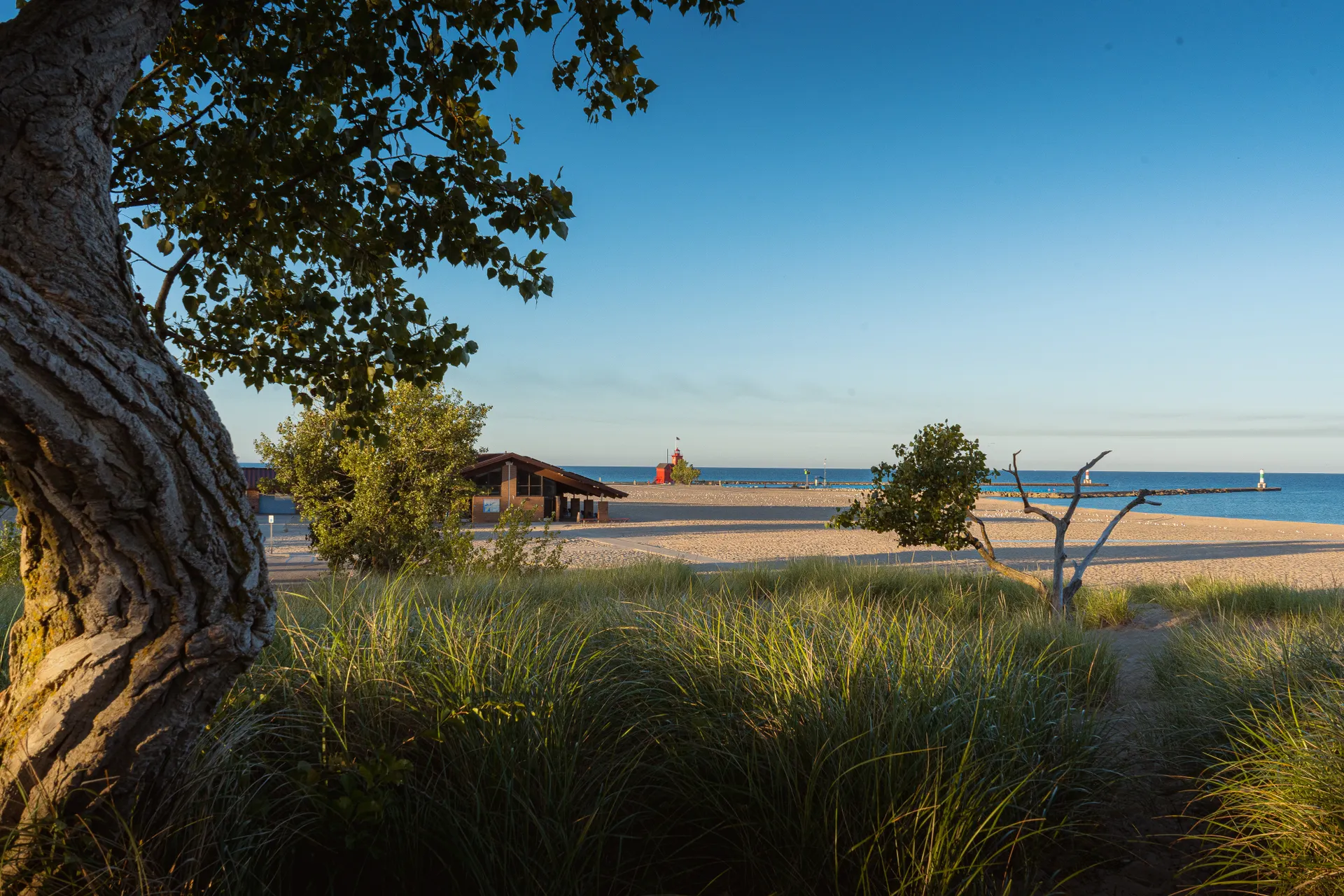
Arrive in Traverse City · Lake Michigan beaches
Most trips start at Traverse City (TVC), the gateway to northern Michigan and your base for the first few days, though you can also drive up from Detroit (DTW) in about 4 hours. Get settled, then walk the beaches: the West Grand Traverse Bay shoreline and Clinch Park are right downtown, with clear, surprisingly turquoise Great Lakes water.
Spend the afternoon getting a feel for Traverse City, the self-styled Cherry Capital of the World. Wander the downtown for cherry everything (pie, jam, dried cherries), grab a lakeside dinner, and watch the sunset over the bay. This is the relaxed, summer-resort half of Michigan, so ease into it.
- West Grand Traverse Bay beachesClinch Park & downtown shoreline · clear turquoise Great Lakes water
- Downtown Traverse CityCherry Capital of the World · pie, jam, lakeside dining
- Drive in from Detroit (optional)DTW ~4 hr · or fly into Traverse City (TVC)
- Stay in Traverse CityYour base for the Lower Peninsula · book summer weekends ahead
- Fly into Traverse City (TVC) for the quickest start, or drive up from Detroit (DTW) in about 4 hours if you want a one-way Lower-to-Upper loop.
- Traverse City is a busy summer resort town. Book lodging well ahead for July and August, and especially around the National Cherry Festival in early July.
- The Great Lakes water is fresh, clear, and cold. Pack layers; even in summer the beach can be breezy and the water bracing.

Sleeping Bear Dunes · the Dune Climb & Pierce Stocking Drive
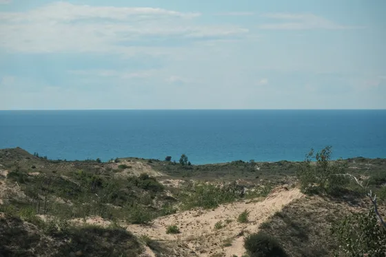
Drive about 40 minutes west to Sleeping Bear Dunes National Lakeshore, one of the most spectacular stretches of freshwater coast anywhere. Start with the famous Dune Climb, a steep wall of sand you scramble up for a sweeping view, with the option to push all the way over to Lake Michigan (a tough out-and-back through soft sand).
Then drive the Pierce Stocking Scenic Drive, a 7.4-mile loop with overlooks including the jaw-dropping Lake Michigan Overlook, where the dunes drop 450 feet straight to the water. Cap the day in Glen Arbor or back in Traverse City. If you have energy, the beaches at Glen Haven and along the lakeshore are some of the best in the Midwest.
- Steep sand wall · sweeping views · optional tough push to Lake Michigan
- 7.4-mi loop · Lake Michigan Overlook drops 450 ft to the water
- Glen Haven & lakeshore beachesSome of the best freshwater beaches in the Midwest
- Night in Traverse City or Glen ArborStay near the lakeshore or back at your Traverse City base
- The Dune Climb is harder than it looks. Going all the way over to Lake Michigan and back is a strenuous 3.5-mile round trip through deep, soft sand, so bring water and time it for morning or evening, not midday heat.
- Sleeping Bear charges an entrance fee (about $25 per vehicle for 7 days), or use an America the Beautiful pass.
- Pierce Stocking Scenic Drive is one-way and closes seasonally. Stop at every overlook; the Lake Michigan Overlook is the highlight of the loop.
Traverse City wineries, cherries & a paddle near the dunes
Spend a slower day around Traverse City. The Old Mission and Leelanau peninsulas that reach into the bay are lined with wineries and farm stands, famous for cool-climate whites and cherry wines, with tasting rooms strung along easy scenic loops. This is cherry country, so look for orchards and roadside stands selling the summer harvest.
For something active, head back toward Glen Arbor and paddle the Crystal River, a gentle, scenic float near Sleeping Bear. Crystal River Outfitters runs easy kayak and canoe trips through the woods and marsh, a perfect lazy-summer afternoon. Book a guided or self-guided paddle and let the slow current do the work.
- Easy scenic paddle near Sleeping Bear · Glen Arbor · book ahead
- Old Mission & Leelanau wineriesCool-climate whites & cherry wines · scenic peninsula tasting loops
- Cherry orchards & farm standsSummer cherry harvest · pie, jam, fresh fruit roadside
- Last night in Traverse CityPack up for the drive north to the Mackinac Bridge tomorrow
- Crystal River Outfitters in Glen Arbor runs easy kayak and canoe trips near Sleeping Bear. Book ahead on summer weekends and bring sun protection and water shoes.
- If you tour wineries, plan a designated driver or a tasting tour; the Old Mission and Leelanau peninsulas spread tasting rooms over a lot of scenic miles.
- Cherry season peaks in July. Watch for roadside farm stands selling fresh sweet and tart cherries straight from the orchard.
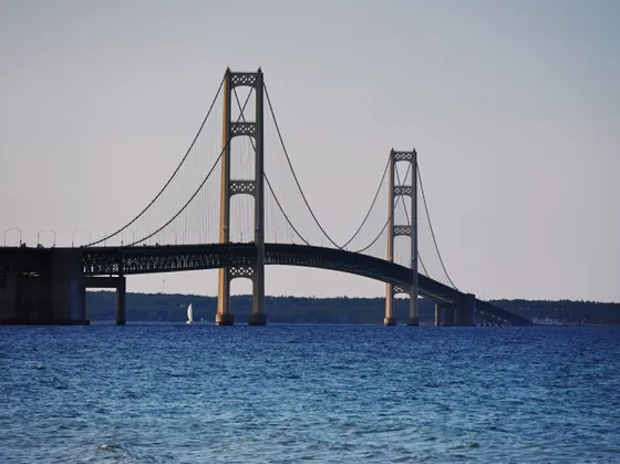
North across the Mackinac Bridge · Mackinaw City
Today you cross from the Lower Peninsula into the Upper. It is about 2.5 to 3 hours north from Traverse City to Mackinaw City, the jumping-off point at the tip of the mitten. Just beyond it, the Mackinac Bridge soars five miles over the Straits of Mackinac, where Lake Michigan meets Lake Huron, one of the longest suspension bridges in the world and a genuine highlight to drive.
Mackinaw City and St. Ignace on the north side are the ferry ports for Mackinac Island. Settle in near the bridge, grab dinner with a view of the Straits, and get your ferry sorted for tomorrow. If you want, you can ferry over and overnight on the island itself, but most travelers day-trip it and stay on the mainland.
- Drive the Mackinac BridgeFive miles over the Straits of Mackinac · Lake Michigan meets Lake Huron
- Traverse City to Mackinaw City~2.5 to 3 hr north · fuel up before crossing into the U.P.
- Straits of Mackinac viewsSunset over the bridge from Mackinaw City or St. Ignace
- Stay near the bridgeMackinaw City or St. Ignace · ferry ports for Mackinac Island
- The Mackinac Bridge has a toll (about $4 per car). It can be windy and the deck is high, so take it steady if you are nervous about heights.
- Book your Mackinac Island ferry ahead in summer. Ferries leave from both Mackinaw City and St. Ignace, and you leave your car at the dock since no cars are allowed on the island.
- This is the day to fill the tank. Gas and services thin out fast once you are deep in the Upper Peninsula.
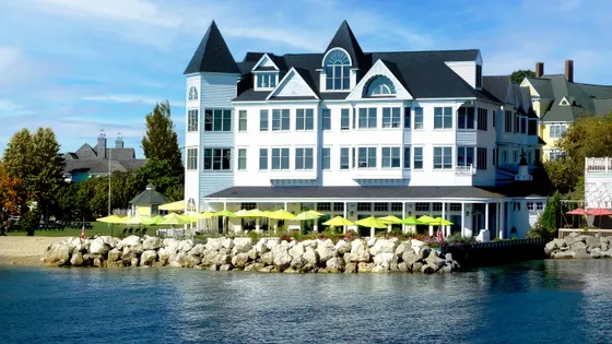
Mackinac Island · ferry, bikes, fudge & no cars
Catch the morning ferry to Mackinac Island, a step-back-in-time place where cars have been banned since the 1890s. Everything moves by bike, horse-drawn carriage, or on foot. Rent a bicycle and ride the flat 8.2-mile loop on M-185, the only state highway in America with no cars, hugging the Lake Huron shoreline the whole way past Arch Rock and the lighthouse.
Up in the village, the air smells like fudge, the island's signature sweet, made fresh in shop windows along Main Street. Visit the grand Fort Mackinac above town, stroll past the historic Grand Hotel, and soak up the Victorian streetscape. Take an afternoon or evening ferry back to the mainland, or overnight on the island if you booked ahead.
- Ferry to Mackinac IslandFrom Mackinaw City or St. Ignace · book ahead in summer · no cars allowed
- Bike the 8.2-mile M-185 loopThe only car-free state highway · flat shoreline ride past Arch Rock
- Fudge shops & Fort MackinacFresh fudge on Main Street · historic fort and Grand Hotel above town
- Back to the mainland (or overnight)Most day-trip it · island lodging is pricey and books far ahead
- Take the first ferry you can to beat the day-trip crowds, and bring or rent a bike; the shoreline loop is the best way to see the island and is flat and easy.
- No cars means no driving on or off the island. Leave your vehicle at the ferry dock parking on the mainland.
- Fudge is the island tradition, but it is also touristy and pricey. Buy a little, ride the loop, and you have done Mackinac right in a day.
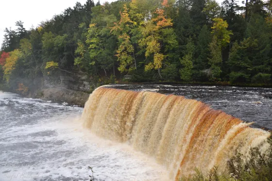
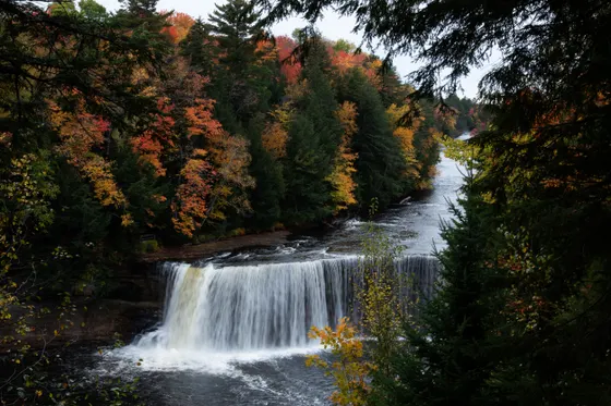
Tahquamenon Falls · root-beer-colored cascades
Head west into the heart of the eastern U.P. to Tahquamenon Falls State Park, home to one of the largest waterfalls east of the Mississippi. The Upper Falls are nearly 50 feet tall and 200 feet wide, and the water runs a distinctive amber, root-beer color, stained by tannins from the cedar and hemlock swamps upstream.
Walk the easy boardwalks and overlooks at the Upper Falls, then drive a few minutes to the gentler Lower Falls, a series of smaller cascades around an island where you can rent a rowboat in summer. It is about 1.5 to 2 hours from the bridge, so this is a drive-and-explore day. Continue west and overnight toward Munising to set up for Pictured Rocks tomorrow.
- Nearly 50 ft tall, 200 ft wide · amber, root-beer-colored water
- Gentler cascades around an island · summer rowboat rentals
- Drive west toward MunisingLong U.P. drive · set up for Pictured Rocks tomorrow
- Night in MunisingBase for the Pictured Rocks boat cruise · book ahead in summer
- Michigan state parks require a Recreation Passport (about $14 per vehicle for the year) for entry, not a per-park fee. Add it when you register your car or buy it at the park.
- The root-beer color is natural, from tannins leached out of the cedar swamps upstream. It is not pollution.
- Drives are long in the U.P. Tahquamenon to Munising is a couple of hours, so leave early and fuel up whenever you pass a station.
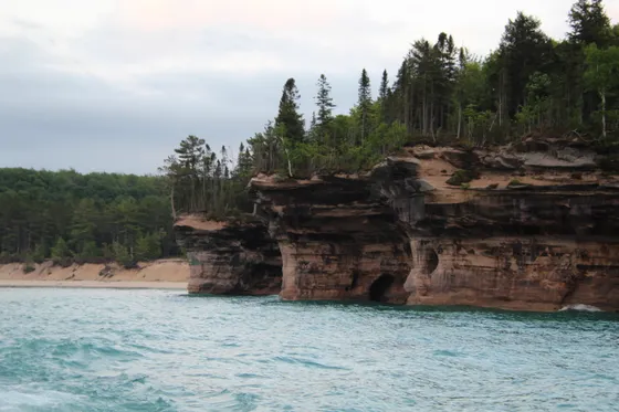
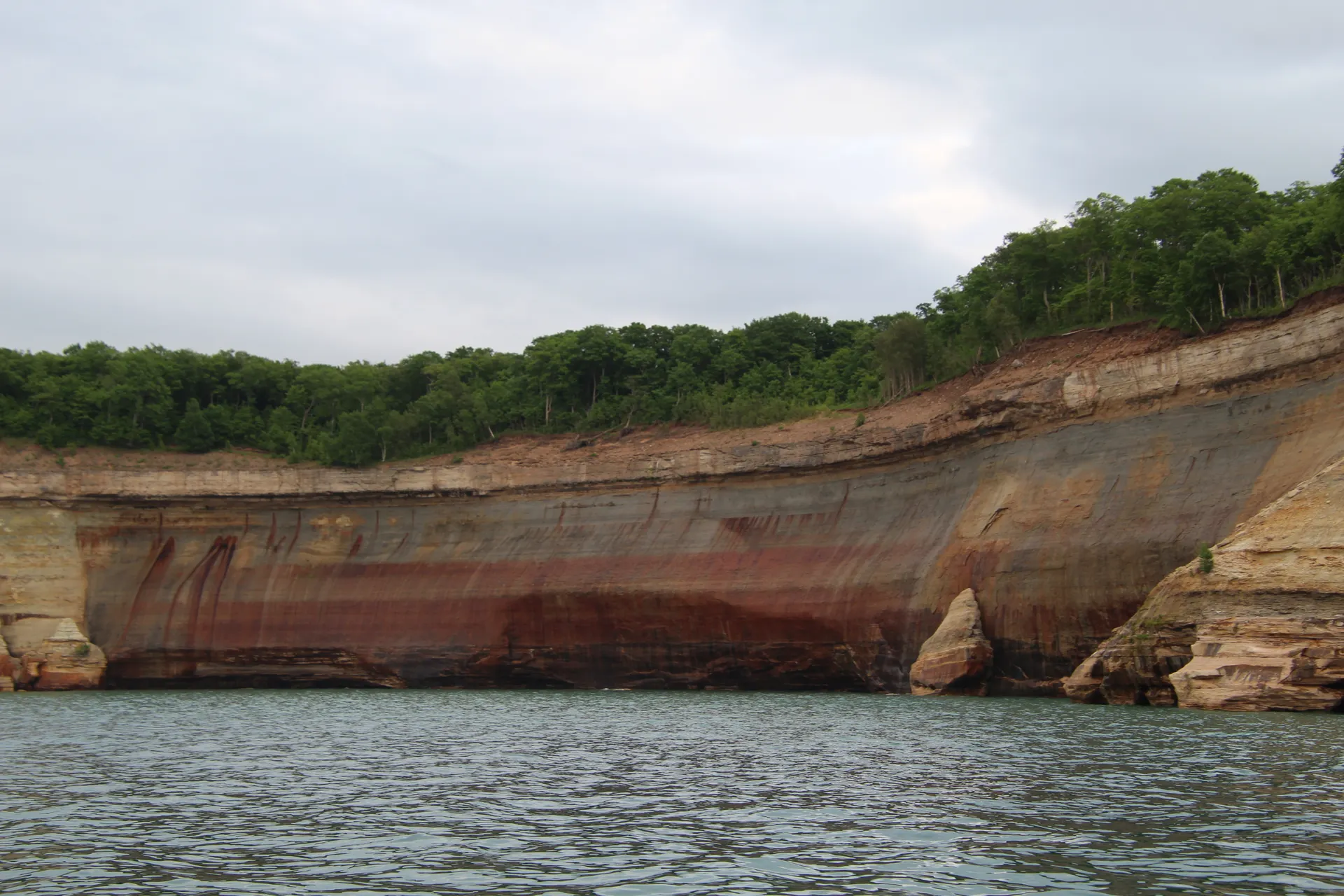
Pictured Rocks · the Munising boat cruise & Miners Castle
Today is one of the trip's highlights: Pictured Rocks National Lakeshore, 15 miles of multicolored sandstone cliffs rising straight out of Lake Superior, streaked red, orange, and green by mineral seeps. The best way to see them is from the water, so book the Pictured Rocks boat cruise out of Munising, which glides right beneath the painted cliffs, sea caves, and Bridalveil Falls.
On land, drive out to Miners Castle, the park's most famous overlook, where a turreted rock formation juts over impossibly clear turquoise water, and walk down to Miners Beach. With more time, the Chapel Loop and Mosquito Beach offer some of the best hiking on the lakeshore. Spend a second night in Munising.
- From Munising · the only way to see the painted cliffs up close · book ahead
- The park's signature rock formation over turquoise Lake Superior
- Some of the best lakeshore hiking · waterfalls and clifftop views
- Second night in MunisingStay put so you can catch a morning or sunset cruise
- The boat cruise is the single best way to experience Pictured Rocks. Reserve it ahead for summer, and pick a calm-water or sunset sailing if you can; the colors glow in low light.
- Miners Castle and the cliff overlooks can also be reached by car and short walks, so you get the cliffs from both the water and above.
- Lake Superior is cold even in August. Pack a layer for the cruise; it is breezy and chilly out on the open water.
Marquette · Presque Isle & Lake Superior
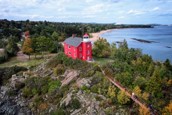
Drive about 45 minutes west to Marquette, the largest city in the Upper Peninsula and a great base for the western U.P. Set on Lake Superior, it has a walkable downtown, a lively food and brewery scene, and an iconic ore dock on the harbor. It is a welcome bit of city energy after days in the wild.
Spend the afternoon at Presque Isle Park, a forested peninsula jutting into Lake Superior right in town, with a scenic loop drive, rocky cliffs, and Black Rocks where locals leap into the cold, clear water. Catch the sunset over the lake, then settle into Marquette for the night before pushing on to the Keweenaw.
- Presque Isle ParkForested Lake Superior peninsula in town · scenic loop, Black Rocks
- Marquette harbor & ore dockIconic ore dock · Lake Superior waterfront · brewery scene
- Drive west from Munising~45 min · Marquette is the U.P.'s biggest city and hub
- Stay in MarquetteWalkable downtown · good base for the western U.P.
- Marquette has its own airport (MQT) with regional flights, so it is a handy place to end a one-way trip if you flew into Traverse City or Detroit.
- Presque Isle Park has a one-way scenic loop drive that is closed to cars at times for walkers and cyclists; check the posted hours.
- Use Marquette to refuel, resupply, and do laundry. Towns get small and far apart again once you head into the Keweenaw.
The Keweenaw · copper history & Lake of the Clouds
Push into the wild far north: the Keweenaw Peninsula, a finger of land reaching into Lake Superior with a deep copper-mining past. Drive through Houghton and Calumet, where 19th-century copper history still lines the streets, then follow the scenic Brockway Mountain Drive near Copper Harbor for one of the highest paved views in the Midwest.
A bit south, in the Porcupine Mountains Wilderness State Park, walk to the overlook above Lake of the Clouds, where a mirror-still lake sits cradled in a forested escarpment, the U.P.'s most photographed view and unforgettable in fall color. These are long drives over big country, so pick the corner of the Keweenaw that excites you most and base nearby for the night.
- Porcupine Mountains · the U.P.'s most famous view · stunning in fall
- Copper history: Calumet & Houghton19th-century copper-mining towns · museums and historic streets
- Brockway Mountain DriveNear Copper Harbor · one of the highest paved views in the Midwest
- Night in the KeweenawBase near Houghton, Copper Harbor, or the Porkies
- The Keweenaw is remote and spread out. Pick a focus, copper history around Calumet, Copper Harbor and Brockway Mountain, or the Porcupine Mountains, since you cannot easily do it all in a day.
- Lake of the Clouds is a short walk from the parking area to the overlook, so it is an easy payoff for the long drive. Go for sunrise or in late-September color.
- This is the most isolated stretch of the trip. Top off gas, carry snacks and water, and do not count on cell service.
Back down & getting home
On your final day you turn for home. From the western U.P. it is a long but scenic drive back east: roughly 2 hours to Marquette (MQT) if you are flying out from there, or a much bigger haul if you are looping all the way back to Traverse City (TVC) or Detroit (DTW). Plan this leg generously; the Upper Peninsula does not do quick drives.
Getting home: the simplest one-way endings fly out of Marquette (MQT) or Traverse City (TVC). If you started and end at Detroit (DTW), budget the better part of a day to recross the Mackinac Bridge and come back down the Lower Peninsula. Either way, leave with daylight to spare, fuel up before the long empty stretches, and take one last look at Lake Superior before you go.
- Getting home: MQT, TVC or DTWMarquette ~2 hr · Traverse City or Detroit is a full-day drive back
- Recross the Mackinac BridgeOnly if looping back to the Lower Peninsula · budget plenty of time
- One last Lake Superior viewPull over for a final shoreline stop before the long drive
- Flying out of Marquette (MQT) saves the long drive back. Compare it against TVC and DTW when you book, since a one-way rental can be worth it.
- If you must loop back to Detroit, it is a full day of driving including the Mackinac Bridge. Break it up with a stop rather than pushing straight through.
- Gas stations are sparse in the far U.P. Fill up before you leave town and again whenever you pass a station on the way out.
Now build your Michigan road trip.
You've seen all ten days. Open the free drag-and-drop planner and tune it for your dates, your pace, and whether you base in Traverse City, Munising, or Marquette.
What we actually learned on the road.
Go June through September
Summer is peak season and the only time the ferries, boat cruises, and beaches are all in full swing. Expect crowds in July and August. Late September brings spectacular fall color across the Upper Peninsula, with thinner crowds and crisp air, though some seasonal businesses begin to close.
Book the ferry and cruise ahead
Two things sell out: the Mackinac Island ferry and the Pictured Rocks boat cruise out of Munising. Reserve both in advance for summer weekends. U.P. lodging is limited too, so book Munising and Marquette early rather than hoping to find a room on arrival.
Plan for long drives
The Upper Peninsula is huge and empty. Sights are hours apart, and the route from the Lower Peninsula up and across to the Keweenaw covers around 900 miles. Build in driving days, do not over-schedule, and treat the long, scenic legs as part of the trip.
Fuel up whenever you can
Gas stations and services thin out fast once you cross into the U.P. and become genuinely sparse in the Keweenaw. Top off the tank in every town you pass, carry snacks and water, and do not rely on finding a station open late in the far north.
Know the passes you need
Sleeping Bear Dunes and Pictured Rocks are national lakeshores with a federal entrance fee (or use an America the Beautiful pass). Michigan state parks like Tahquamenon and the Porcupine Mountains use the Recreation Passport (about $14 per vehicle per year), added when you register your car or bought at the park.
Respect the big lakes
Lake Michigan and Lake Superior are cold, deep, and powerful even in summer. Watch for rip currents and big surf on windy days, especially at the dune beaches, and pack a warm layer for boat cruises; the open water is always breezy and chilly.
Everything you'll actually want to know.
Ready to go? Get your
Michigan road trip route.
Two peninsulas mapped over 10 days: the dunes and wineries, the Mackinac Bridge and car-free island, Tahquamenon and Pictured Rocks, Marquette and the Keweenaw, with drive times, ferry and cruise booking notes, and where to base each night.
Instant book · Free cancellation · Secure payment via Stripe

Planning this trip?
Save it, share it with your crew, or find travelers heading the same way.

Liked this itinerary?
What other travelers are saying
Be the first to leave a tip or question for the next traveler.