Three Days in the Porkies:
A Lake Superior Loop
Three days backpacking the Porkies in Michigan's western Upper Peninsula: the Escarpment Trail above Lake of the Clouds, the Big Carp River waterfalls, Summit Peak, and the Lake Superior shore.
Free interactive planner · drag & reorder your days, add stops, map it in minutes
Build your own Porkies trip, drag, reorder & map it.
Drag stops between days, swap trails, and add your own overlooks and waterfalls with the place search. The live map and walking distances recalculate as you go, so you can shape a loop that matches your pace and your reserved backcountry sites.
Opens a side panel · reorder days, add custom stops, see your route live
One wilderness park, old-growth, ridgelines & Lake Superior, in the western UP.
The Porcupine Mountains Wilderness State Park, the Porkies to anyone who has been, sprawls across nearly 60,000 acres of Michigan's western Upper Peninsula on the shore of Lake Superior. It protects one of the largest old-growth northern hardwood forests left in the United States, a tangle of virgin maple, hemlock, and yellow birch laced with rivers, waterfalls, and low ancient mountains.
This 3-day route is built around Porcupine Mountains backpacking: the Escarpment Trail riding the cliffs above the iconic Lake of the Clouds, the Big Carp River Trail with its string of waterfalls down to Lake Superior, and the Summit Peak observation tower at the high point of the park. You will mix the best ridgeline hiking with old-growth forest, the Lake Superior shoreline, and the famous Presque Isle River falls.
Late spring through October is the window. Fall color, usually late September into early October, is what the Porkies are famous for and draws hikers from across the Midwest. Early summer brings blackflies and mosquitoes, so pack a head net. Winter is for skiing, not backpacking, with deep lake-effect snow burying the trails.

Backcountry camping in the Porkies uses dispersed sites plus rustic cabins and yurts that you reserve through the Michigan DNR reservation system, and the cabins book up far in advance for fall-color weekends. You also need a Michigan Recreation Passport, or a daily vehicle pass, to enter the state park. Reserve your sites or cabin early, and pick up your pass and a backcountry map at the visitor center.
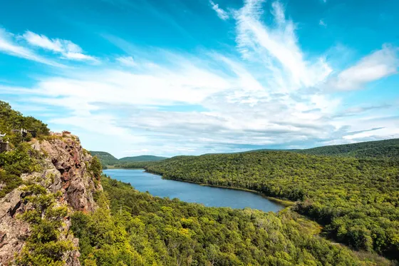

Lake of the Clouds & the Escarpment Trail
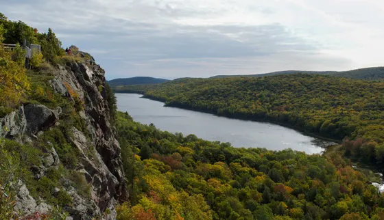
Get your Recreation Passport and backcountry permit sorted at the visitor center, then drive to the Lake of the Clouds Overlook at the end of South Boundary Road. This is the single most photographed view in Michigan: a long blue lake cradled in old-growth forest far below, walled in by the Porcupine ridgeline. Soak it in from the paved overlook before you shoulder your pack.
From the overlook, set out on the Escarpment Trail (about 4 miles one way), the finest ridge walk in the park. It rides the open cliff tops directly above Lake of the Clouds, with the lake and the Big Carp River valley unfolding below you the whole way past Cloud Peak and Cuyahoga Peak. Drop off the escarpment to a reserved backcountry site or rustic cabin near the Big Carp River for your first night in the wilderness.
- The iconic Porkies view · paved overlook at the end of South Boundary Road
- ~4 mi one way · moderate · cliff-top ridge above the lake · best in the park
- Vehicle entry pass + backcountry permit at the visitor center
- Night one near the Big Carp RiverReserved dispersed site or rustic cabin via the Michigan DNR
- Stop at the visitor center first for your Recreation Passport, a backcountry permit, and a current trail-conditions and bridge-status update before you head in.
- The Escarpment Trail is fully exposed on the cliff tops, so save it for a clear day and hike it for the open views over Lake of the Clouds.
- Backcountry sites, cabins, and yurts are reserved through the Michigan DNR reservation system and fill far ahead for fall-color weekends, so book before you arrive.
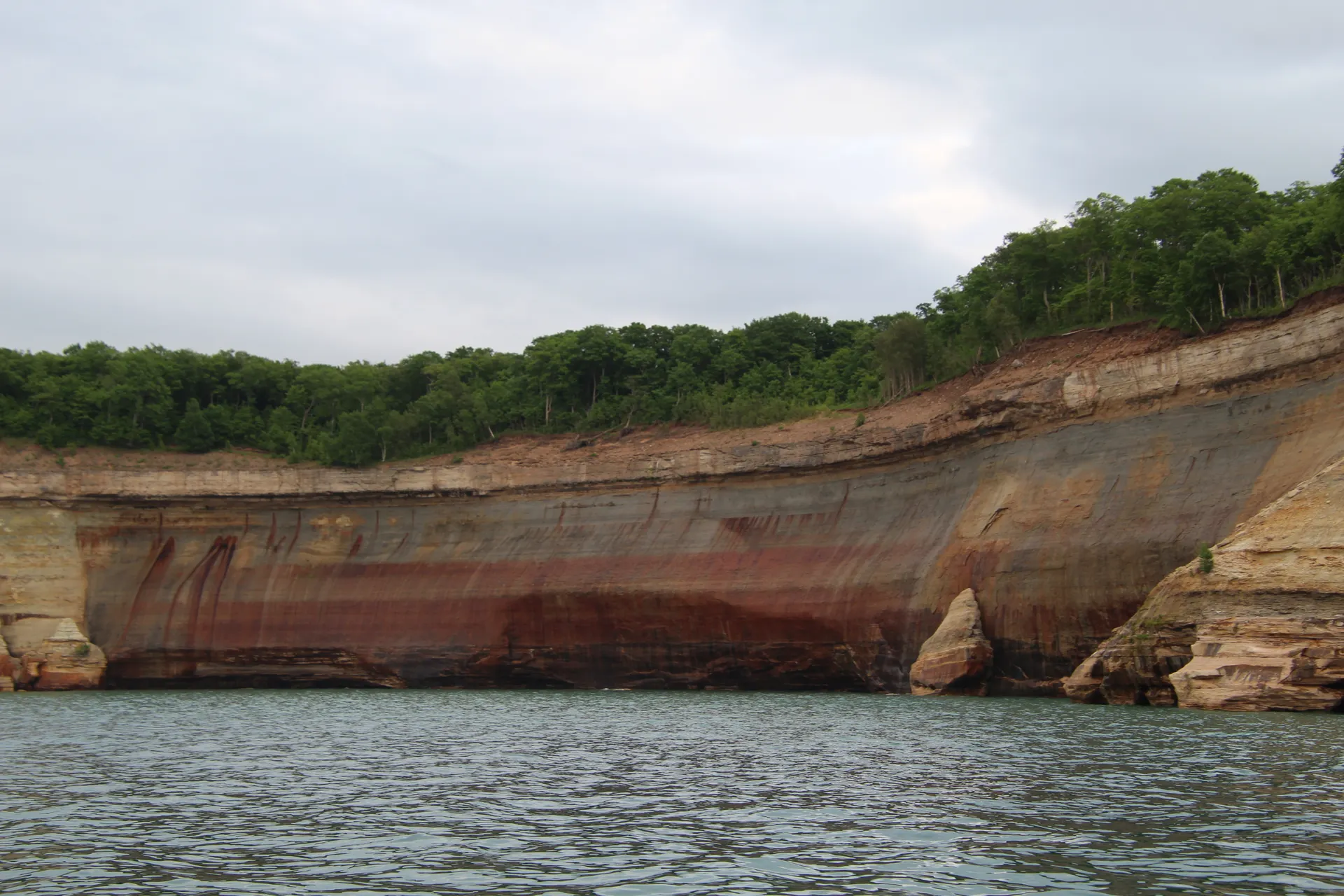
Big Carp River waterfalls down to Lake Superior

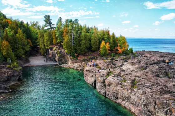
Today you follow the Big Carp River Trail (about 9 miles), the heart of a Porkies backpacking trip, as it descends the river valley through deep old-growth forest. The trail strings together one waterfall after another, including Shining Cloud Falls, the largest on the river, with the water dropping over dark rock between mossy hemlocks. It is rugged, rooty Upper Peninsula hiking, so take it slow and watch your footing on the wet rock.
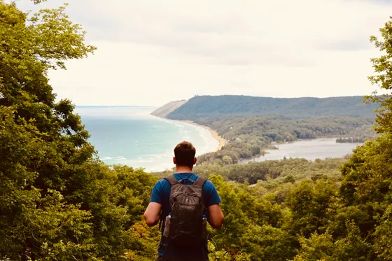
The river delivers you to the Lake Superior shoreline at the mouth of the Big Carp, where the trail meets the Lake Superior Trail along the great lake itself. Walk a stretch of cobble beach with the biggest freshwater lake in the world stretching to the horizon, then camp at a reserved lakeshore site and fall asleep to the sound of Superior's surf.
- ~9 mi · moderate · waterfalls including Shining Cloud Falls · old-growth
- Shoreline trail along the great lake · cobble beaches · driftwood
- Mouth of the Big Carp RiverWhere the river meets Lake Superior · classic lakeshore camp area
- Night two on the Lake Superior shoreReserved lakeshore dispersed site or cabin via the Michigan DNR
- The Big Carp River Trail is the waterfall route, with Shining Cloud Falls the biggest on the river. Build in time to stop at each one rather than racing the 9 miles.
- Porkies trails are notoriously rooty and can be muddy or slick, especially near the waterfalls, so wear sturdy boots and take wet rock slowly.
- A reserved site at the mouth of the Big Carp on Lake Superior is one of the best camps in the park. Filter your water and treat the lake like the ocean in a blow.
Summit Peak tower & the Presque Isle River falls
On your last morning, climb to Summit Peak, the highest point in the park, where a boardwalk and stairs lead to an observation tower with a sweeping view over the whole rolling old-growth wilderness, out to Lake Superior, and on a clear day to the Apostle Islands of Wisconsin. The short Government Peak Trail and the Summit Peak area give you a final taste of the high country before you hike out.
Cap the trip at the far west end of the park on the Presque Isle River, where a loop of boardwalks and stairs links three powerful waterfalls, Manabezho, Manido, and Nawadaha Falls, as the river churns through a gorge of ancient rock to Lake Superior. Getting home: from the park it is roughly an hour to Ironwood and about 1.5 hours to Houghton (CMX), so base your last night in Silver City or Ontonagon and start the drive out rested.
- Highest point in the park · boardwalk + tower · views to Lake Superior
- Old-growth ridge trail · links the high country and the interior
- Manabezho, Manido & Nawadaha Falls · boardwalk loop at the west end
- Getting home: Houghton or IronwoodIronwood ~1 hr · Houghton (CMX) ~1.5 hr · base in Silver City or Ontonagon
- The Summit Peak tower is reached by a short boardwalk-and-stairs climb and gives the best overall view of the park, so save it for a clear morning.
- The Presque Isle River falls sit at the far west end of the park, a drive from Lake of the Clouds, so plan the loop of Manabezho, Manido, and Nawadaha as a separate stop.
- There is no fuel or supplies deep in the park. Base your last night in Silver City near the entrance or in Ontonagon up the shore, and fill up before the drive to Houghton or Ironwood.


Now build your Porkies trip.
You've seen all three days. Open the free drag-and-drop planner and tune it for your dates, your pace, and whether you base in Silver City near the park entrance or in Ontonagon up the shore.
What we actually learned in the Porkies.
Buy a Michigan Recreation Passport
Every vehicle entering the state park needs a Michigan Recreation Passport, or a daily vehicle pass. Add it when you renew your plates, buy it online through the Michigan DNR, or pick one up at the park entrance and visitor center.
Reserve backcountry sites, cabins & yurts early
Porkies backpacking uses dispersed backcountry sites plus rustic cabins and yurts that you reserve through the Michigan DNR reservation system. The cabins are coveted and book months ahead for fall-color weekends, so lock in your dates as early as you can.
Time it for fall color, late September to early October
The Porkies are famous for autumn color, usually peaking late September into early October across one of the largest old-growth hardwood forests in the country. Late spring through October is the backpacking window; winter buries the trails in lake-effect snow.
Pack a head net for early-summer bugs
Blackflies and mosquitoes can be fierce in late spring and early summer, especially near the rivers and old-growth interior. Bring a head net, repellent, and a tent with good netting, or aim for cooler, drier fall dates.
Expect rugged, rooty, signal-free trails
Porkies trails are remote, rooty, and often muddy, with stream crossings that can run high after rain. Cell service is nearly nonexistent in the backcountry, so carry a paper backcountry map from the visitor center and tell someone your route and exit day.
Base in Silver City or Ontonagon
There is no gas or store deep in the park. Silver City sits right by the entrance and Ontonagon is a short drive up the Lake Superior shore, both with lodging, fuel, and food. Fly into Houghton (CMX) or Ironwood and drive in.
Everything you'll actually want to know.
Ready to go? Get your
Porcupine Mountains route.
Trailheads and mileages, the Escarpment ridge, the Big Carp River waterfalls, Lake Superior camps, Summit Peak, the Presque Isle falls, DNR reservations, and drive times from Houghton and Ironwood.
Instant book · Free cancellation · Secure payment via Stripe


Planning this trip?
Save it, share it with your crew, or find travelers heading the same way.

Liked this itinerary?
What other travelers are saying
Be the first to leave a tip or question for the next traveler.