3 Days on the Lakeshore Trail:
Pictured Rocks
Three days backpacking the Pictured Rocks Lakeshore Trail above Lake Superior: Miners Castle, Mosquito Beach, Chapel Rock and Chapel Falls, Spray Falls, Grand Portal Point, the Log Slide, and the Grand Sable Dunes.
Free interactive planner · drag & reorder your days, add stops, map it in minutes
Build your own Pictured Rocks trip, drag, reorder & map it.
Drag stops between days, adjust your campsites, and add your own overlooks and waterfalls with the place search. The live map and trail miles recalculate as you go, and we will flag a day that runs too long with a full pack on an exposed cliff trail.
Opens a side panel · reorder days, add custom stops, see your route live
One trail, cliffs, waterfalls & dunes, above Lake Superior.
Pictured Rocks National Lakeshore stretches for more than 40 miles along the south shore of Lake Superior in Michigan's Upper Peninsula, named for the multicolored sandstone cliffs that rise straight out of the cold blue water. The Lakeshore Trail, a signed section of the North Country Trail, runs the full length of the park from Munising to Grand Marais and is the classic way to see it all on foot.
This 3-day route is built for Pictured Rocks backpacking: a point-to-point walk past Miners Castle, Mosquito Beach, Chapel Rock with its famous tree growing on a sandstone arch, Spray Falls tumbling straight into the lake, Grand Portal Point, the Log Slide, the Au Sable Light Station, and the Grand Sable Dunes. Most hikers cover the roughly 42 miles over 3 to 4 days, camping at the reserved backcountry sites along the way.
June through September is the window. Biting flies and mosquitoes peak in early summer, and the trail and dunes can be glorious with color in late September. Lake Superior stays frigid all year, so the water is for cooling your feet, not swimming. Because the trail is point-to-point, you must arrange a shuttle, and a backcountry permit with reserved campsites is required through recreation.gov.
A backcountry permit and reserved campsites are required for every night, and they are booked through recreation.gov. Popular sites like Mosquito, Chapel, and Coves fill fast for summer weekends, so reserve as early as you can. The trail is point-to-point, so line up a shuttle between Munising and Grand Marais before you go, and treat or carry water since you are camping along the cliffs.

Munising to Mosquito Beach · Miners Castle & the first cliffs
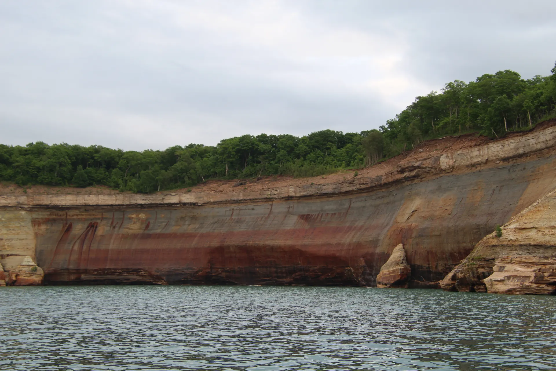
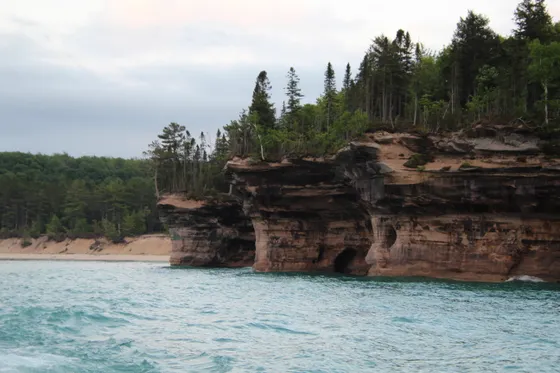
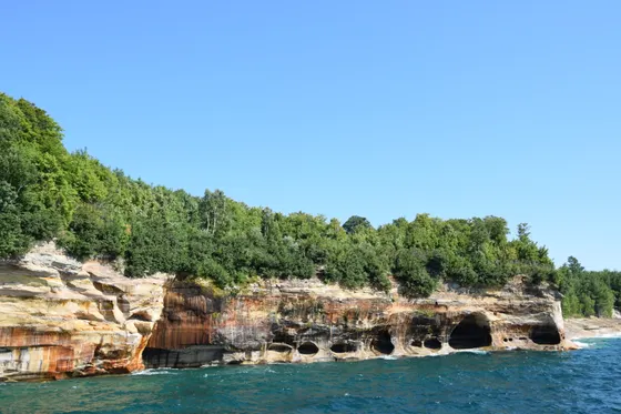
Sort your shuttle and pick up your backcountry permit, then start from the Munising end of the Lakeshore Trail. The first miles roll through forest and along the bluffs, with a worthwhile stop at Miners Castle, the park's most famous formation, a turreted sandstone point standing above the impossibly blue water. From here the cliffs begin in earnest.
The trail continues east to Mosquito Beach and the Mosquito River, one of the prettiest stretches of shoreline in the park, with flat sandstone shelves and clear water. Camp at the reserved Mosquito backcountry site (or nearby Cliffs) so you fall asleep to Lake Superior. Filter your water, hang or stash your food, and remember the lake is frigid even in July.
- The park's most famous formation · turreted sandstone above the lake
- Signed North Country Trail · bluffs and forest to the first cliffs
- Flat sandstone shelves · clear water · classic shoreline
- Reserved permit site · book ahead on recreation.gov
- You must have a reserved backcountry permit for every night. Print or save it and pick it up per the recreation.gov instructions before you start.
- Miners Castle is also reachable by car, so it can be busy by day. Hit it early or enjoy it as a midday break as you pass through on foot.
- Filter or treat all water from Lake Superior and the creeks. Camp only at your reserved site, and keep your food secured overnight.
 Lakeshore Trail
 Chapel Beach
The cliff miles · Chapel Rock, Spray Falls & Grand Portal Point
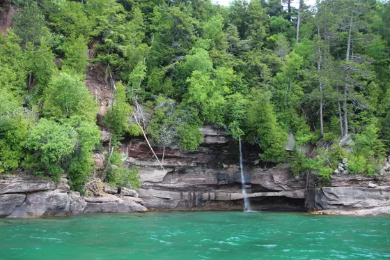
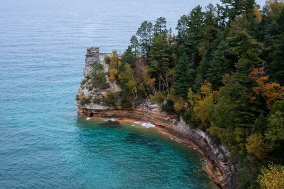
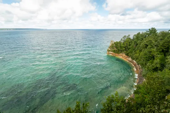
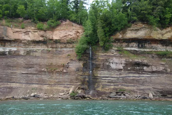
Spray FallsGrand Portal PointThis is the heart of the trip and the most spectacular cliff walking in the park. Side-trip up to Chapel Falls, then drop to Chapel Beach and Chapel Rock, the iconic sandstone arch with a lone pine growing on top, its roots stretched across the gap to the mainland. From here the trail clings to the cliff tops past Grand Portal Point, one of the great viewpoints on Lake Superior.
Continue to Spray Falls, where a creek pours straight over the cliff edge into the lake, best seen from the trail above or from the water. Camp at the reserved Chapel or Coves backcountry site to break up the long cliff miles. Stay back from crumbling, undercut cliff edges, especially when they are wet, and keep kids and dogs close.
- Short side trip · waterfall above Chapel Beach
- The iconic tree on the sandstone arch · a Pictured Rocks signature
- One of the great cliff-top viewpoints on Lake Superior
- A waterfall pouring straight off the cliff into the lake
- Reserved permit site · books up fast for summer weekends
- The cliff edges are sandstone and can be undercut and crumbling. Stay well back from the rim, especially when it is wet, and keep children and dogs leashed.
- Chapel Rock and Grand Portal Point are the photographic heart of the trip. Plan to be on this stretch in good morning or evening light if you can.
- Reserve the Chapel or Coves sites early. They are among the most popular on the trail and sell out quickly for summer weekends on recreation.gov.
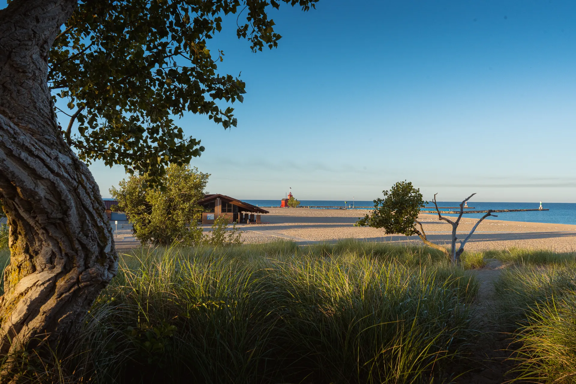
The Log Slide, Au Sable Light & the Grand Sable Dunes
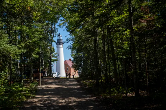
The final stretch trades cliffs for sand and lighthouse history. Climb to the Log Slide, a steep dune overlook where loggers once sent timber sliding 300 feet down to the lake, with a huge view back toward the cliffs and ahead to the dunes. A spur leads to the Au Sable Light Station, a classic Lake Superior lighthouse on the point, often the highlight of the day.
The trail then runs above the Grand Sable Dunes, perched sand banks rising hundreds of feet above the lake, before easing down toward Grand Marais at the eastern end of the park. Getting back: your shuttle car or service meets you in Grand Marais. From here it is roughly an hour west to Munising and about an hour and a half to Marquette (MQT) for flights out.
- Steep 300-ft dune to the lake · big views both directions
- Classic Lake Superior lighthouse · short spur off the trail
- Perched dunes hundreds of feet above the lake · the sandy finale
- Finish & shuttle from Grand MaraisPick up your shuttle car · ~1 hr to Munising · ~1.5 hr to Marquette (MQT)
- The Log Slide looks like an easy run down to the lake but climbing back up the soft 300-foot slope is exhausting. Enjoy the view from the top.
- Build in time for the Au Sable Light Station spur. It is one of the most photogenic stops on the whole route and easy to skip if you are rushing.
- Confirm your shuttle pickup in Grand Marais before you start the trip. Marquette (MQT) is the nearest airport, roughly an hour and a half away.
Now build your Pictured Rocks trip.
You have seen all three days. Open the free drag-and-drop planner and tune it for your dates, your pace, and whether you start from Munising or run the shuttle from Grand Marais.
What we actually learned on the Lakeshore Trail.
Reserve a backcountry permit and campsites
Every overnight on the Lakeshore Trail needs a backcountry permit with reserved campsites, booked through recreation.gov. Popular sites like Mosquito, Chapel, and Coves fill fast for summer weekends, so reserve as early as you can and camp only at your assigned site.
It is point-to-point, so plan a shuttle
The trail runs one way from Munising to Grand Marais, about an hour apart by road. Arrange a hiker shuttle or spot a second car at the far end before you start. Most hikers run the shuttle so they can walk west to east and finish at the dunes.
Filter your water and respect Lake Superior
There is no potable water on the trail, so filter or treat from the lake and creeks. Lake Superior is frigid year-round and the water is for cooling off, not swimming. Sudden storms and waves can blow up fast, so do not rely on the shoreline as a route.
Stay back from the sandstone cliffs
The 200-foot multicolored sandstone walls are soft, often undercut and crumbling, and whole sections can collapse suddenly into Lake Superior, so never stand close to the raw cliff edge for photos. Stay well back from the rim, especially when it is wet, keep children and dogs leashed, and never try to climb down to the water from the cliff tops.
Hike June through September
Summer and early fall are the window. Biting flies and mosquitoes peak in early summer, so pack a head net and repellent. Late September can bring beautiful color but cold nights. Snow lingers into spring and the trail is a winter undertaking after that.
Base in Munising or Grand Marais
Spend a night in Munising before you start or in Grand Marais after you finish to handle logistics. Both are small Upper Peninsula towns with limited lodging that books up in summer, so reserve ahead. Marquette (MQT) is the nearest airport, about an hour out.
Everything you'll actually want to know.
Ready to go? Get your
Pictured Rocks route.
Trail miles and campsites, the backcountry permit you need, shuttle logistics between Munising and Grand Marais, the boat cruise add-on, and the cliff-safety timing for backpacking Pictured Rocks.
Instant book · Free cancellation · Secure payment via Stripe
Know these trails yourself? Become a local guide and host free community hikes.


Planning this trip?
Save it, share it with your crew, or find travelers heading the same way.
What other travelers are saying
Be the first to leave a tip or question for the next traveler.
How was your experience?
Tell us what worked and what did not. It goes straight to Yulia and Margarita.