The Case for Non-Digital Navigation
Most hikers treat GPS as a necessity rather than a luxury, which creates a serious vulnerability: when the phone dies, the battery runs out in the cold, or the screen shatters on a rock, their navigation capability drops to zero. People who develop traditional navigation skills don't have this problem. A paper map and baseplate compass work at -20°F, in driving rain, after a ten-foot drop, and with no signal whatsoever.
You don't need to abandon your GPS app, it's genuinely useful. But treating it as your only navigation tool is like hiking with only one trekking pole. The skill set in this guide takes a few hours of practice to develop and will serve you for every hike you ever take.
The Three Navigation Tools You Need
Traditional land navigation uses three things: a topographic map of your area, a baseplate compass (not a button compass or watch compass), and your own observation of the terrain around you. Each tool provides something the others can't.
The map shows you the shape of the land: where ridges, valleys, streams, and trails are, and how they relate to each other. The compass gives you a reliable direction reference that doesn't depend on landmarks, it points toward magnetic north regardless of where you are or what you can see. Your terrain observation connects the map and compass to the actual ground beneath your feet.
Setting Your Map to North
Before you do anything else, orient your map. An oriented map is one where the north arrow on the map points toward actual north, meaning the map's depiction of the land matches the real terrain around you. When your map is oriented, features you see on the ground (a ridge to your left, a valley ahead) appear in the same relative positions on the map.
To orient with a compass: place the compass on the map with the edge of the baseplate aligned along the map's north-south grid lines. Rotate the map (and compass together) until the compass needle aligns with the north arrow on the compass housing. The map is now oriented to magnetic north. Note that for precise navigation you'd also account for magnetic declination (the difference between magnetic north and true north), but for basic orientation in most hiking situations, this approximation works fine.
Finding Your Location on the Map
Knowing where you are on a map is called getting a fix. There are several ways to do this, each useful in different situations.
Landmark identification: Look around and identify distinctive terrain features you can see, a peak, a lake, a distinctive bend in a river. Find those same features on the map. Your location is somewhere that would give you that view of those features. The more features you can identify and cross-reference, the smaller the area your position could be in.
Dead reckoning: If you know where you started and have been tracking your direction and distance, you can calculate where you should be. This requires knowing your average hiking speed (typically 2–2.5 mph on flat terrain, less on steep terrain), the direction you've been traveling (from your compass), and how long you've been walking. It's not precise, but it gets you in the right neighborhood.
Triangulation (resection): This is the most accurate non-GPS method. Take a compass bearing to two or three distinct landmarks you can identify on both the map and the real landscape. Plot each bearing on the map as a line extending from the landmark in the direction opposite to your bearing (this is called back-bearing). Where the lines intersect is your position. With two bearings you get an approximate fix; three bearings give you a small triangle of error that you can average.
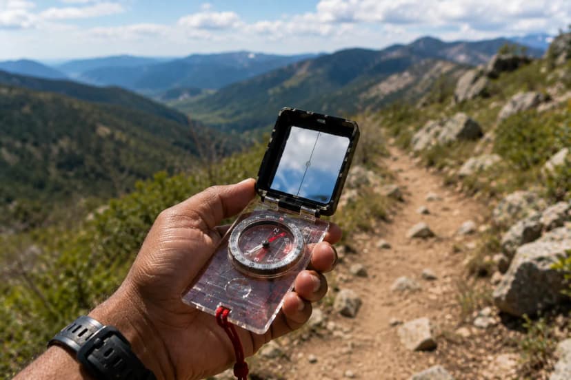
How to Take a Compass Bearing
Point the direction-of-travel arrow on your compass toward the landmark you want a bearing to. Hold the compass level and steady at waist height. Rotate the housing until the orienting arrow (the outlined arrow on the housing floor) aligns with the north end of the magnetic needle. Read the bearing in degrees from the index mark at the top of the baseplate. That number is your magnetic bearing to the landmark.
To walk on a bearing: set the bearing on the housing, hold the compass flat, and turn your body until the needle aligns with the orienting arrow. The direction-of-travel arrow now points at your destination. Pick a landmark on that line, a tree, a rock, anything distinctive, walk to it, then re-check your compass and pick the next landmark. Don't walk with your eyes glued to the compass; look up and navigate feature to feature.
Accounting for Magnetic Declination
Magnetic north and true north are not the same place. In the continental United States, the difference (called declination) ranges from about 0° in parts of the Midwest to more than 20° in the Pacific Northwest and Maine. If you're using a map based on true north (as most topo maps are) and a compass pointing to magnetic north, you need to correct for this difference or your bearings will be off.
The map legend shows the declination for that region. In the western US, magnetic north is east of true north, you subtract the declination from your compass bearing to get a true bearing. In the eastern US, magnetic north is west of true north, you add. The easiest approach: buy a compass with an adjustable declination correction (most quality baseplate compasses have this), set it once for your region, and forget about it.
Reading Terrain to Confirm Your Position
Maps and compasses are confirmation tools. The primary navigation tool is your eyes and your understanding of what the terrain around you should look like based on where you think you are.
Before each significant section of trail, look at the map and ask: what should I be seeing? If the map shows a ridgeline to my right and a drainage descending to my left, and that's what I see, I'm on route. If the map shows a ridgeline on my right but I'm looking at flat ground, something is wrong, either my position or my understanding of the map.
Develop the habit of checking in with the terrain every 15–20 minutes. Note the direction water drains, the orientation of ridges, and whether the slope angle matches what the contour lines predict. This continuous terrain awareness means you catch route deviations early, when they're easy to fix, rather than after a significant detour.
Navigating in Low Visibility
Fog, heavy rain, darkness, and whiteout snow conditions eliminate your ability to read terrain visually. In these conditions, navigation becomes almost entirely compass-based and requires more precision.
Before visibility drops (ideally at the trailhead, before you leave), note the compass bearing from your current position to your destination. If conditions deteriorate, you can navigate primarily on bearing and elapsed time. Walk on the bearing, track your time and pace, and use terrain features only when they're close enough to observe safely.
In dense fog above treeline, staying on a ridge rather than a slope reduces the risk of walking off an edge. Use the compass to confirm the ridge direction and walk along the spine, rechecking bearing frequently. Mark your last known good position in your mind before continuing into low-visibility terrain.
Staying Found vs. Getting Un-Lost
The best navigation strategy is continuous position awareness, knowing where you are at all times, not just when you're confused. Check the map at every junction, every distinct terrain feature, every time you stop for water or a snack. This habit costs almost nothing and means you always have a reference point if your route becomes uncertain.
At trailheads and major junctions, note the compass bearing back to that point. If you need to retreat, you know exactly which direction to walk. On out-and-back hikes, periodically look behind you so you recognize the terrain from the return direction, trails often look completely different when you're walking them in reverse.
Natural Navigation as a Last Resort
In a true emergency without any tools, natural cues can give you rough directional information. In the Northern Hemisphere, the sun rises in the northeast in summer and the southeast in winter, transits due south at solar noon, and sets in the northwest or southwest. At night, Polaris (the North Star) sits within 1° of true north, find the Big Dipper and follow the two stars forming the outer edge of its cup upward about five times their distance; Polaris is the moderately bright star at that point.
Moss and lichen growth patterns are not reliable direction indicators despite popular belief. Water flow direction (downhill) is reliable, following any stream eventually leads to lower elevation and often to civilization. If you're truly lost without tools, staying put and signaling for rescue is usually safer than navigating by these rough methods.