
New Mexico Wilderness:
A 10-Day Itinerary
A 10-day loop through wild New Mexico: the Gila Wilderness and its cliff dwellings, Carlsbad Caverns, White Sands, Bandelier, Valles Caldera, the Rio Grande Gorge near Taos, and the Bisti Badlands.
Free interactive planner · drag & reorder your days, add stops, map it in minutes
Build your own New Mexico trip, drag, reorder & map it.
Drag stops between days, swap a cave for a dune field, and add your own canyons and hot springs with the place search. The live map and drive times recalculate as you go, and we'll warn you before you build a day no one survives across these remote distances.
Opens a side panel · reorder days, add custom stops, see your route live
One state, caves, dunes, cliffs & rivers, all in wild New Mexico.
New Mexico is the wildest of the Southwest states and one of the least crowded, a high-desert sweep of volcanic country, ancient cliff dwellings, gypsum dunes, and river canyons. It holds the Gila Wilderness, designated in 1924 as the world's first wilderness area, alongside two national parks and a string of monuments and preserves that almost no one rushes through.
This 10-day loop mixes it all: caves and dunes, cliff dwellings and ladders, huge volcanic grasslands, and the Rio Grande slicing its gorge near Taos. You'll explore the Gila Cliff Dwellings and a soak in wild hot springs, descend into Carlsbad Caverns for the Big Room and the bat flight, walk the gypsum dunes of White Sands, climb ladders to ancestral Puebloan rooms at Bandelier, watch elk on the grasslands of Valles Caldera, raft the Rio Grande Gorge, and finish among the hoodoos of the Bisti/De-Na-Zin Badlands.
Spring and fall are the prime seasons. New Mexico spans a huge elevation range, from low desert to high peaks, so expect afternoon storms during the summer monsoon (July through September), cold nights even when days are warm, and long remote stretches with few services. Carry water, fuel up often, and plan for big drives between stops.
Carlsbad Caverns now requires timed-entry reservations, so book your cave entry ahead through recreation.gov. The Valles Caldera preserve and the Gila Cliff Dwellings have limited hours and seasonal access, and the Rio Grande raft season runs spring into early summer, so reserve ahead. Distances are long and services are sparse, so fill up in town and bring far more water than you think you need.


Fly in & drive to Silver City · gateway to the Gila
Start in Albuquerque (ABQ) or El Paso (ELP) and make the long drive southwest to Silver City, the historic mining town that is the gateway to the Gila country. It is roughly 4 hours from Albuquerque or about 2.5 hours from El Paso, through wide-open high desert with few services, so fill up and stock up before you leave the interstate.
Settle into Silver City for the night. This walkable old town has good food, galleries, and the last reliable services before you head deep into the Gila. Use the evening to buy supplies and water, because the road up to the cliff dwellings is slow and remote, and you will want an early start tomorrow.
- Drive to Silver City~4 hr from ABQ · ~2.5 hr from El Paso · fuel up first
- Explore historic downtown Silver CityGalleries, food, and the last good services before the Gila
- Stock up on water & suppliesRemote Gila country ahead · few services beyond town
- Stay in Silver CityGateway town · base for the Gila Wilderness
- Silver City is the last town with full services before the Gila Cliff Dwellings, so stock up on water, food, and gas here.
- The road from Silver City up to the cliff dwellings is winding and slow, around 2 hours each way, so plan an early start for tomorrow.
- Spring and fall are ideal. In summer, plan for afternoon monsoon storms and cooler mountain nights even when town is warm.
The Gila Wilderness · cliff dwellings & hot springs
Drive the slow, scenic road north into the Gila Wilderness, the world's first designated wilderness, set aside in 1924. Walk the loop trail up to the Gila Cliff Dwellings, a cluster of stone rooms built into canyon alcoves by the Mogollon people over 700 years ago, reached by a short climb that ends among the cool cliff chambers.
Afterward, soak in one of the area's wild hot springs along the Gila River, a classic reward after the drive in. The Gila is remote backcountry with almost no cell service, so check current conditions at the visitor center, carry plenty of water, and give yourself time to drive the winding road back before dark.
- Mogollon cliff rooms · short loop climb · check hours
- Soak in a Gila River hot springWild riverside springs · check conditions at the visitor center
- Current trail, road & spring conditions · little cell service
- Stay near the Gila or back in Silver CityLimited lodging up here · many return to Silver City
- The Gila Cliff Dwellings are reached by a roughly 1-mile loop with a short climb into the alcoves. Check seasonal hours before you drive up.
- Wild hot springs near the Gila River are unmaintained. Test the water temperature, avoid putting your head under, and pack out everything you bring.
- There is almost no cell service in the Gila. Download offline maps and tell someone your plan before heading into the backcountry.
The Catwalk near Glenwood & the long drive east
Before leaving the Gila, detour to the Catwalk Recreation Area near Glenwood, a metal walkway suspended over Whitewater Canyon where the trail clings to the cliffs above a rushing creek. It is a short, dramatic leg-stretcher and one of the most unusual trails in the state, built along the route of an old mining-era water pipeline.
Then begin the long transfer east across southern New Mexico toward Carlsbad, your base for the caverns. It is a big driving day across wide, empty country, so fuel up, carry snacks and water, and break it up at viewpoints along the way. Arrive in Carlsbad in time to rest before an early start at the caverns tomorrow.
- Suspended walkway over Whitewater Canyon · short & dramatic
- Long drive east to CarlsbadBig transfer across southern New Mexico · fuel up & break it up
- Carry water & snacks for the driveWide empty country · few services between towns
- Stay in CarlsbadBase for Carlsbad Caverns · gateway town
- The Catwalk near Glenwood can be damaged or closed after floods. Check the Gila National Forest for current status before you drive out.
- The drive from the Gila to Carlsbad is long and remote. Fill up your tank in every town you pass through, because gaps between gas stations are wide.
- Book a timed-entry reservation for Carlsbad Caverns tonight if you have not already, since walk-in entry is limited.

Carlsbad Caverns · the Big Room & the bat flight
Spend the day underground at Carlsbad Caverns National Park. Walk in through the steep Natural Entrance or take the elevator down, then circle the Big Room, an enormous chamber the size of several football fields, decorated with towering stalagmites, draperies, and columns along a roughly 1.25-mile self-guided loop 750 feet below the surface.
In the warmer months, stay for the famous bat flight at dusk, when hundreds of thousands of Brazilian free-tailed bats spiral up out of the Natural Entrance to feed. Reserve your timed entry ahead through recreation.gov, bring a layer because the cave stays around 56°F, and check the bat-flight program schedule at the visitor center.
- ~1.25 mi self-guided loop · 750 ft down · timed entry required
- Steep ~1.25 mi descent on foot · or take the elevator
- Hundreds of thousands of bats at dusk · seasonal · check schedule
- Second night in CarlsbadStay put after the bat flight · gateway town
- Carlsbad Caverns requires a timed-entry reservation booked ahead through recreation.gov, plus the park entry fee. Reserve before you arrive.
- The cave stays around 56°F year-round, so bring a light layer even in summer, and wear shoes with grip for the slick paved trails.
- The bat flight happens at dusk from roughly late spring through October. Check the program time at the visitor center, and note phones and cameras are not allowed at the amphitheater.
White Sands National Park · the gypsum dunes
Drive west to White Sands National Park, the world's largest gypsum dunefield, where 275 square miles of brilliant white sand roll like snow across the Tularosa Basin. Drive the Dunes Drive into the heart of the dunefield, then hike out among the dunes on the marked Alkali Flat Trail or the easier interdune boardwalk.
Time your visit for late afternoon when the heat eases and the low sun turns the dunes gold and pink, and stay for sunset. Bring plenty of water and sun protection, because there is no shade out on the gypsum. Note the park sits beside a military range and occasionally closes for a couple of hours during missile tests, so check the schedule before you go.
- ~8 mi each way into the heart of the dunefield
- ~5 mi loop across open dunes · follow the markers · no shade
- Gold and pink light · cooler air · best time to be out
- Stay near Alamogordo or Las CrucesGateway towns · check for missile-test closures first
- White Sands occasionally closes for up to a couple of hours for missile tests on the adjacent range. Check the park's closure schedule before you drive out.
- There is no shade and no water in the dunefield. Carry plenty of water, wear sun protection, and follow the trail markers, since footprints vanish fast in the wind.
- Late afternoon into sunset is the best and coolest time on the dunes. Bring a sled if you want to slide the slopes, and head out before the gates close.
Drive north to Santa Fe & Bandelier country

Make the drive north up the Rio Grande corridor toward Santa Fe and the high country around Los Alamos, climbing out of the low desert into pinyon-juniper mesas and pine forest. It is a long but scenic transfer, and a good day to break the drive with a meal and a stop in Santa Fe's historic plaza before continuing up onto the Pajarito Plateau.
Base near Bandelier or in the Los Alamos and Santa Fe area for the next couple of nights, the springboard for the cliff dwellings, the Valles Caldera, and the high Pecos and Sangre de Cristo country to come. You are now in cooler, higher terrain, so expect chilly nights and the chance of afternoon storms in monsoon season.
- Drive north up the Rio Grande corridorLow desert up to high mesas and pine forest · scenic transfer
- Stop in Santa Fe's historic plazaBreak the drive · food, adobe streets, galleries
- Climb onto the Pajarito PlateauHigher, cooler country · gateway to Bandelier & Valles Caldera
- Stay near Los Alamos or Santa FeBase for Bandelier and the Valles Caldera
- You are gaining a lot of elevation today, so pack warmer layers for the nights even if the desert was hot.
- Santa Fe is a good place to break the drive, refuel, and stock up before the higher country around Bandelier and the Valles Caldera.
- In monsoon season (July to September), plan outdoor time for the morning, since afternoon thunderstorms build quickly over the higher terrain.
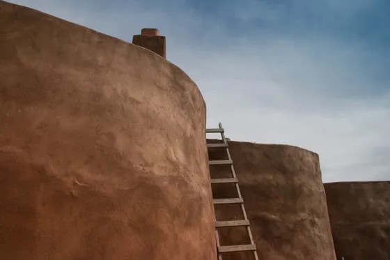
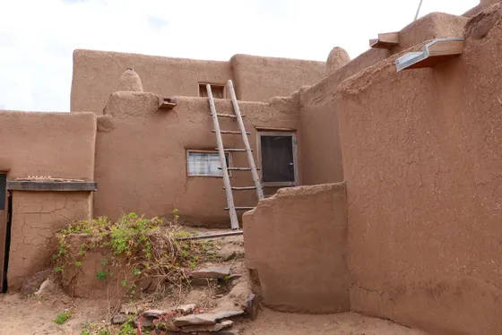
Bandelier National Monument · cliff dwellings & ladders
Spend the day at Bandelier National Monument, where ancestral Puebloan people carved homes into the soft volcanic tuff of Frijoles Canyon over 800 years ago. Walk the Main Loop Trail past the pueblo ruins and cavates, then climb the wooden ladders up into the cliff dwellings themselves, hand- and toeholds and all.
If you have energy, continue on the spur to the Alcove House, a ceremonial cave reached by 140 feet of ladders bolted to the cliff, with a long-house view back down the canyon. In peak season you ride a shuttle into Frijoles Canyon, so check the access rules at the visitor center and start early to beat both the heat and the crowds.
- ~1.4 mi loop · pueblo ruins, cavates & ladders into the cliffs
- 140 ft of ladders to a ceremonial cave · optional spur
- Seasonal mandatory shuttle into the canyon · check the rules
- Second night near Los Alamos or Santa FeStay put · short hop to the Valles Caldera tomorrow
- In peak season you must ride a shuttle into Frijoles Canyon rather than driving in. Check the current access rules at the visitor center.
- The cliff-dwelling ladders are steep and exposed. Wear good shoes, use both hands, and skip them if you are uneasy with heights.
- Alcove House involves 140 feet of ladders to a ceremonial cave. It is optional and not for everyone, but the view back down the canyon is the highlight for many.
Valles Caldera Preserve & drive to Taos
Start at Valles Caldera National Preserve, a vast circular grassland 13 miles across that fills the crater of a collapsed supervolcano. The huge green valleys, or valles, are some of the best places in New Mexico to see elk, especially at dawn and dusk, and the rolling meadows ringed by forested domes feel like nowhere else in the state.
In the afternoon, drive over the mountains to Taos, your base for the next two nights. Taos sits on a high mesa above the Rio Grande with the Sangre de Cristo peaks behind it, an artists' town with deep Puebloan roots. Settle in for the evening, because tomorrow you head down into the river gorge.
- Valles Caldera National Preserve13-mi-wide volcanic grassland · elk at dawn & dusk · check hours
- Walk a valle meadow trailRolling grasslands ringed by forested domes · wildlife watching
- Drive over the mountains to TaosScenic mountain crossing to the high mesa town of Taos
- Stay in TaosArtists' town on the Rio Grande mesa · base for the gorge
- Valles Caldera has limited hours and seasonal road access, with some areas reached only by permit or shuttle. Check the preserve's current conditions before you go.
- Dawn and dusk are the best times to see elk grazing the grasslands. Keep your distance and stay in pullouts, especially during the fall rut.
- Taos sits above 6,900 feet, so nights are cold year-round. Pack layers even in summer.
Rio Grande Gorge & Wild Rivers · rafting near Taos
Today is about the river. The Rio Grande del Norte cuts an 800-foot gorge across the mesa just west of Taos, spanned by the high Rio Grande Gorge Bridge and protected upstream in the Wild Rivers area where the Rio Grande and the Red River meet. Walk the rim, then drop down into the canyon to see the river from below.
For the best way to experience it, book a guided Rio Grande raft trip with Kokopelli / Durango River Trippers, running spring into early summer when the snowmelt is high. The famous Taos Box and Racecourse runs slice through black basalt walls you cannot reach on foot. Whitewater season is short, so reserve ahead, and carry layers because the canyon is cold and the water colder.
- Guided Rio Grande / Chama raft trip · spring to early summer · book ahead
- Rio Grande Gorge BridgeHigh bridge over the 800-ft gorge · walk the span for the views
- Wild Rivers rim & canyon trailsWhere the Rio Grande meets the Red River · rim views and steep descents
- Second night in TaosStay put · short drive to the gorge and Wild Rivers
- Rio Grande whitewater runs strongest with spring snowmelt, roughly April into June. Book your raft trip ahead, since the high-water window is short.
- The canyon and the river stay cold. Bring layers, and the outfitter will provide wetsuits and gear for the bigger runs.
- The Wild Rivers canyon trails are short but very steep, dropping fast to the river and climbing back out. Carry water and pace the return.
Bisti/De-Na-Zin Badlands & the loop home
For a wild finale, drive west across northern New Mexico to the Bisti/De-Na-Zin Badlands, a remote BLM wilderness of eroded clay, petrified wood, and otherworldly hoodoos scattered across the bare desert. There are no marked trails: you simply wander out across the cracked ground to find the strangest rock formations, so set a waypoint at the parking area and navigate back to it.
The Pecos Wilderness in the Sangre de Cristos is another wild option if you would rather stay near Taos and hike high alpine country instead. Either way, this loop ends back toward Albuquerque (ABQ) for your flight out. Top off your gas, carry water and a GPS or offline map for the trackless badlands, and leave time for the long drive to the airport.
- Bisti/De-Na-Zin BadlandsBLM wilderness of hoodoos · no marked trails · navigate by GPS
- Pecos Wilderness (alternative)High Sangre de Cristo alpine hiking near Taos · if you skip Bisti
- Loop back to Albuquerque (ABQ)Long drive to the airport · fuel up & leave with daylight
- Carry water & a GPS for the badlandsNo trails, no shade, no services · set a waypoint at the car
- The Bisti Badlands have no trails, signs, shade, or water. Set a GPS waypoint at the parking lot and carry plenty of water, because it is easy to lose your bearings among the hoodoos.
- The access road and the clay ground turn to impassable mud after rain. Avoid Bisti right after storms, and never drive onto wet clay.
- If you would rather hike high alpine instead, the Pecos Wilderness near Taos and Santa Fe is a strong substitute. Either way, fuel up and leave plenty of daylight for the drive back to Albuquerque.
Now build your New Mexico trip.
You've seen all ten days. Open the free drag-and-drop planner and tune it for your dates, your pace, and whether you base in Silver City, Taos, or Carlsbad.
What we actually learned across New Mexico.
Reserve Carlsbad Caverns ahead
Carlsbad Caverns now requires a timed-entry reservation booked through recreation.gov, on top of the park entry fee. White Sands charges its own fee, and the America the Beautiful pass ($80) covers entry to both national parks. Reserve cave entry before you arrive.
Fuel up often across long distances
New Mexico is big and empty. The Gila, the drive to Carlsbad, and the run out to Bisti all cross wide stretches with few or no services. Fill your tank in every town you pass through, because the next gas station can be 60 miles or more away.
Carry far more water than you think
From the gypsum dunes to the trackless badlands, much of this route is high desert with no shade and no water on the trails. Carry at least a gallon per person per day, and never head out onto the dunes or into Bisti without plenty to drink.
Expect little to no cell service
The Gila, Bisti, Valles Caldera, and much of the open country have little or no signal. Download offline maps, set a GPS waypoint at trackless trailheads like Bisti, and tell someone your plan before heading into the backcountry.
Go in spring or fall
Spring and fall are the prime seasons, with mild days and cool nights. Summer brings the monsoon (July to September), so plan outdoor time for the morning and clear high ground before afternoon storms. Winter is cold and snowy in the high country.
Mind the big elevation range
This trip swings from low desert at White Sands and Carlsbad to high mountains at Taos and the Valles Caldera, over 7,000 feet. Pack warm layers for cold nights even in summer, and give yourself a beat to adjust to the altitude up north.
Everything you'll actually want to know.
Ready to go? Get your
New Mexico wilderness route.
Cliff dwellings and cave timings, the gypsum dunes, raft outfitters, gas and water stops, drive times from Albuquerque and El Paso, and the season timing you need to loop wild New Mexico safely.
Instant book · Free cancellation · Secure payment via Stripe


Planning this trip?
Save it, share it with your crew, or find travelers heading the same way.

Liked this itinerary?
What other travelers are saying
Be the first to leave a tip or question for the next traveler.