Valles Caldera, New Mexico: A 2-Day Itinerary
A 13-mile volcanic caldera, grassy valleys & elk in the Jemez.
Two days in Valles Caldera National Preserve: the vast Valle Grande meadow, the Coyote Call and Cerro La Jara hikes, world-class elk viewing, and some of the darkest skies in the country.
“I’ve requested to book a Chain Lakes Loop guide on ExplorOFF, and it was the best idea ever! I highly recommend going with their guided option since you get a real human connection on the trail and don’t have to worry about a thing. Yulia was great to talk to!”




 10 stops on a real mapEvery stop pinned in order→
Valles Caldera: every stop pinned in order.
Valle Grande, Coyote Call & Cerro La Jara · Jemez Mountains
Every stop on this trip, in order, opens as one driving route in the Google Maps app. No copying addresses across one at a time.
Valles Caldera in photos: 5 of the stops.


Plan and book your 2 days in Valles Caldera, one step at a time
How 2 days in Valles Caldera split up
Plan 2 days for Valles Caldera. Caldera width: ~13 mi. Difficulty: Easy–Moderate. Elevation: ~8,000–9,000+ ft. Valles Caldera National Preserve protects a vast 13-mile-wide volcanic caldera in the Jemez Mountains of northern New Mexico, formed when a massive eruption collapsed the mountain roughly 1.25 million years ago. What is left is one of the most striking landscapes in the Southwest: enormous grassy valleys, called valles, rolling between forested volcanic domes, with one of the largest elk herds in the state and some of the darkest night skies anywhere.
Day 1: Into the caldera · the Valle Grande & Coyote Call Trail
5 stops · Day one
Day 2: Cerro La Jara, History Grove & elk under dark skies
5 stops · Day two
Into the caldera · the Valle Grande & Coyote Call Trail
Drive in on NM-4 from Los Alamos or up from Jemez Springs, and the moment the trees open onto the Valle Grande is unforgettable: a vast green sea of grassland, miles across, ringed by forested volcanic domes. This enormous main meadow is the classic Valles Caldera view, and there are pullouts right on NM-4 where you can stop and take it in before you even reach the entrance station.
Not the order you want? Drag a stop, or use the arrows beside it. Stops move between days too.
- Drive from
~45 min · NM-4 · fuel up first · DriveDrive in on NM-4 from Los Alamos, about 45 minutes through the forested Jemez Mountains, or come up from Jemez Springs on the west side. There is no gas inside the preserve, so fill up and grab supplies in town first. The road climbs steadily into high country, so watch for afternoon storms building over the peaks.
- The Valle Grande
The iconic 13-mile caldera meadow · ViewpointThe moment the trees open onto the Valle Grande is unforgettable: a vast green sea of grassland, miles across, ringed by forested volcanic domes. This enormous main meadow is the classic Valles Caldera view, and there are pullouts right on NM-4 where you can stop and take it in before you even reach the entrance station.
 Entrance station
Pay day-use fee · check permit & reservation rules · ViewpointStop at the entrance station to pay the day-use fee, check the interior-road and reservation rules, and grab a map. Access into the preserve interior is gated with limited seasonal hours, and driving the backcountry roads needs a vehicle permit, with some areas requiring an advance reservation, so confirm what is open before heading in.
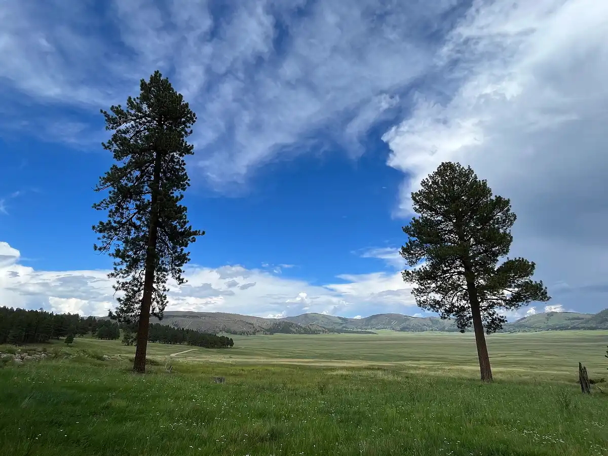 Imp336 / CC BY-SA 4.0Coyote Call Trail
~3.5 mi loop · easy to moderate · caldera views · HikeWarm up with the Coyote Call Trail, about 3.5 miles round trip, a forest-and-meadow loop on the south side of the valley that climbs gently for big open views back across the caldera. Hike it in the morning, since at this elevation afternoon thunderstorms build fast in summer.
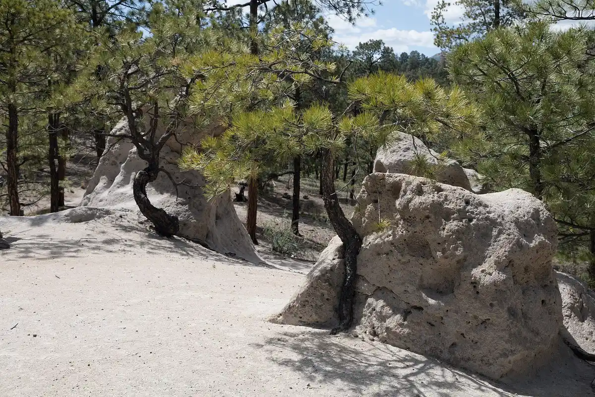 Clyde Charles Brown / CC BY-SA 4.0Stay in Los Alamos
Gateway town · no lodging inside the preserve · lodgeThere is no lodging inside Valles Caldera, so base in Los Alamos, about 45 minutes from the Valle Grande, with the widest range of hotels and restaurants near the preserve. Jemez Springs on the west side and Santa Fe to the east are the other good bases, and Santa Fe has the most options of all.
Cerro La Jara, History Grove & elk under dark skies
Start with the easy Cerro La Jara loop (about 1.4 miles round trip), a gentle walk around a small forested volcanic dome that sits right out in the Valle Grande, perfect for spotting elk and pronghorn out on the grass. From there, wander the History Grove trail through old-growth ponderosa pines and the Valle Grande Trail for more time out in the open meadow, all gentle and family-friendly at altitude.
Not the order you want? Drag a stop, or use the arrows beside it. Stops move between days too.
- Cerro La Jara loop
~1.4 mi loop · easy · dome in the Valle Grande · HikeStart with the easy Cerro La Jara loop, about 1.4 miles round trip, a gentle walk around a small forested volcanic dome that sits right out in the Valle Grande. It is a perfect spot for spotting elk and pronghorn out on the grass, and a good way to ease into the altitude.
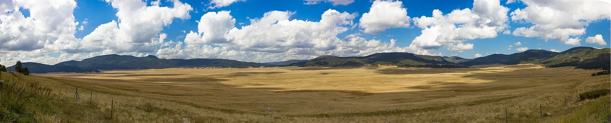 Damien Buie / CC BY-SA 4.0History Grove & Valle Grande Trail
Old-growth pines & open-meadow walks · HikeWander the History Grove trail through old-growth ponderosa pines, then the Valle Grande Trail for more time out in the open meadow. Both are gentle and family-friendly, though everything is at altitude, so take it slow and carry water in the dry mountain air.
- Elk viewing at dawn & dusk
One of NM's largest herds · fall rut · ViewpointValles Caldera has one of the largest elk herds in New Mexico, and elk viewing is world-class at dawn and dusk out on the Valle Grande. The best time is the fall rut in September and October, when you can often hear the bulls bugle across the valley. Keep your distance and bring binoculars.
- Dark-sky stargazing
Among the darkest skies in the U.S. · ViewpointWith no nearby city lights, Valles Caldera has some of the darkest skies in the country, with the Milky Way arching right over the caldera on a clear night. Stay out after dark, but bring real layers, since high-elevation nights get cold even in summer.
- Getting home: Santa Fe or Albuquerque
SAF ~1 hr+ · ABQ ~2 hr · Bandelier on the way · DriveFrom the caldera it is about 45 minutes back to Los Alamos, a little over an hour to Santa Fe (SAF), or roughly 2 hours to Albuquerque (ABQ). Bandelier National Monument and the hot springs around Jemez Springs both make easy add-ons on the way out, so build in time for one if your schedule allows.
Book the 1 night
Beds near the trailheads are the one thing on this trip that genuinely runs out. Everything else can be decided later.
Tell us your dates and we will do the checking. We find what is still open near each trailhead and email you this plan back with a booking link for each night. Nothing is charged and you decide at the end.
Request to bookWhat to pack for Valles Caldera
Built from this route, not a generic list. Every line says why it is here.
On every day of this trip
On your feet
Because you are sleeping indoors
For the driving days
Specific to Valles Caldera
What we actually learned in the caldera.
Pay the day-use fee and check the rules
Valles Caldera charges a day-use entrance fee, and the America the Beautiful pass covers it. Driving the interior backcountry roads requires a separate vehicle permit, and some areas need an advance reservation. Check nps.gov/vall and stop at the entrance station before you head in.
Mind the limited entrance-station hours
Access into the preserve interior is gated and the entrance station keeps limited seasonal hours. You can see the Valle Grande from NM-4 anytime, but to drive the interior roads and reach the trailheads you need to enter while the station is open, so plan an early start.
Hike mornings, watch afternoon storms
At 8,000 to 9,000-plus feet, the Jemez Mountains build thunderstorms almost daily in July and August. Start hikes early, be off exposed meadows and domes by early afternoon, and always pack a rain layer even when the morning looks clear.
Bring layers for cold high-elevation nights
This is high country, so nights are cold even in midsummer and the shoulder seasons can be downright freezing. Dress in layers, carry more water than you expect to drink in the dry air, and pack a warm jacket if you plan to stay out for elk or stargazing.
No services inside, so fuel up first
There is no gas, food, or lodging inside the preserve. Fill up and grab supplies in Los Alamos or Jemez Springs before you turn onto the access road. The nearest reliable services and lodging are all in those gateway towns or in Santa Fe.
Time it for elk, stars, or winter skiing
Summer and early fall are prime, with the elk rut peaking in September and October and the best stargazing on moonless nights. In winter the snowed-in valles become a quiet world for cross-country skiing and snowshoeing, a completely different and beautiful experience.
Valles Caldera: questions before you go
Valles Caldera elk: the questions people ask most.
Valles Caldera National Preserve protects a vast 13-mile-wide volcanic caldera in the Jemez Mountains of northern New Mexico, formed by a massive eruption around 1.25 million years ago. It is famous for its enormous grassy valleys, called valles, rolling between forested volcanic domes, one of the largest elk herds in the state, and some of the darkest night skies in the country.
For Valles Caldera hiking, the standouts are the Coyote Call Trail (about 3.5 miles round trip, a forest-and-meadow loop with big caldera views), the easy Cerro La Jara loop (about 1.4 miles around a dome out in the Valle Grande), the Valle Grande Trail across the open meadow, and the short History Grove walk through old-growth ponderosa pines. Most trails are gentle, but everything sits high, so the altitude is the main challenge.
Two days is ideal. That gives you time to take in the Valle Grande, hike Coyote Call and Cerro La Jara, walk History Grove and the Valle Grande Trail, and still stay out for elk viewing and stargazing at the edges of the day. Many visitors also tack on nearby Bandelier National Monument or the hot springs around Jemez Springs.
You pay a day-use entrance fee, which the America the Beautiful pass covers. Driving the interior backcountry roads requires a separate vehicle permit, and some areas need an advance reservation. The entrance station also keeps limited seasonal hours, so check nps.gov/vall before you go and plan to enter while it is open.
June through October is prime, with summer wildflowers and the famous elk rut peaking in September and October when the bulls bugle across the valley. Summer afternoons bring near-daily thunderstorms, so hike early. In winter the snow-filled valles become a quiet destination for cross-country skiing and snowshoeing, a completely different experience.
Yes. Valles Caldera has one of the largest elk herds in New Mexico, and elk viewing is world-class at dawn and dusk out on the Valle Grande. The best time is the fall rut in September and October, when you can often hear bulls bugling across the meadow. The preserve is also excellent for pronghorn, coyotes, and other wildlife.
There is no lodging inside the preserve, so most visitors base in Los Alamos (about 45 minutes away), the small village of Jemez Springs on the west side, or Santa Fe (a little over an hour east). All three put you within an easy drive of the caldera, and Santa Fe and Los Alamos have the widest range of hotels and restaurants.
The preserve sits along NM-4 in the Jemez Mountains. The nearest major airport is Albuquerque (ABQ), about 2 hours away, with Santa Fe (SAF) a smaller closer option. From Los Alamos it is roughly 45 minutes, and from Santa Fe a little over an hour. There is no gas inside, so fill up in Los Alamos or Jemez Springs before the drive in.
To drive the preserve's interior backcountry roads you need a backcountry vehicle pass, and only a limited number are handed out each day. They are claimed in person at the main entrance station off NM-4, so stop there first thing in the morning to pay your entry and pick up a pass before the daily allotment fills. The interior also sits near 8,500 feet, so build in time to move slowly and manage the altitude fatigue.
Yes. Tell us your dates and we check what is still open for the plan on this page, then send it back with a booking link for each night and the total. Nothing is charged and nothing is held, and you pay the normal rate.
Pick how you want to go.
Same 2-day route. Same 7 stops.
- 1 night, a campsite near Los Alamos
- $15
- 1 night, a room in Los Alamos
- from $132
- A private local guide, rooms and campsites booked
- Included
- Airport pickup and every drive
- Included
- Park, permit and campsite fees paid
- Included
- All the gear and the trail meals
- Included
Written and walked by Yulia Vasilyeva · Co-founder · Lead planner and guide
Three years leading guided hikes in the Pacific Northwest, rated 5.0 by 20+ verified guests, and she builds every custom itinerary herself. Based in Seattle.
Last checked September 2026
You might also love these
Other itineraries near this one.

New Mexico Wilderness: A 10-Day Itinerary
A 10-day loop through wild New Mexico: the Gila Wilderness and its cliff dwellings, Carlsbad Caverns, White Sands, Bandelier, Valles…
Weminuche Wilderness: Chicago Basin Backpacking
Reach Colorado's most remote 14ers by Durango & Silverton steam train. A 4-day backpacking trip to Chicago Basin with three fourteeners…
Mt Sneffels Hike: A 3-Day Colorado 14er Itinerary
Three days on Colorado's prettiest 14er from Ouray: acclimatise in town, drive Yankee Boy Basin, then climb the Lavender Col and the…
Guides for this tripBest Time to Visit Valles CalderaValles Caldera Elk ViewingValles Caldera Hiking Trails
What adventurers say about us.
All reviews are from verified guests. ★★★★★ 5.0 average from 20+ bookings.
"Felt like going out with a really knowledgeable friend who just happens to know everything about the area. No awkward tour-guide energy, just a magnificent day."
"Yulia is an incredible guide. She knew every trail, every viewpoint, and exactly how to pace the day for our group. The photos she took of us were stunning. 100% booking again."
"I was visiting Seattle solo and this was the best decision I made on the trip. Yulia picked me up, had snacks, and took us to a trail I never would have found on my own. Absolute must-do."
"We did this as a couple's trip and it was perfect. Yulia adapted everything to us, our pace, our interests, our photo obsession. The mountain views were unreal."
"Phenomenal experience. Yulia has deep local knowledge and a real passion for the outdoors. She went out of her way to show us the hidden gems tourists never see. Will remember this forever."
"I've done a few guided hikes and this was by far the best. Yulia is warm, funny, and genuinely expert. The trail she chose had the most insane wildflower bloom, we got so lucky."
Fees, reservation windows, shuttle dates and trail closures are planning estimates. Confirm hours, road status and any reservations with the land manager before you go.
What other travelers are saying
Be the first to leave a tip or question for the next traveler.
Was this helpful?
One tap. It goes straight to Yulia and Margarita.
You can't hike it if you can't get the permit.
The best hikes in America run on lotteries that open once a year and sell out in minutes. Every trail runs on its own calendar. Pick the ones you want and we do the watching.
 The WaveCoyote Buttes North · Arizona / UtahPermitLotterybrutal odds
 Half Dome CablesYosemite NP · CaliforniaPermitOpens Mar 1fair odds
 Mt. WhitneyInyo NF · CaliforniaPermitOpens Feb 1tough odds
 Angels LandingZion NP · UtahPermitLotterytough odds
 The SubwayZion NP · UtahPermitLotterytough odds
 Mount St. Helens Summit ClimbGifford Pinchot NF · WashingtonPermitReservationtough odds
How it works
- An email the morning each window opens, never the day after.
- A 14-day heads-up so you can line up your group and dates.
- Win odds and a ranked backup plan for every trail you pick.
Didn't win? We keep watching. We check recreation.gov every day for The Enchantments, Half Dome and Angels Landing, and email you the moment a sold-out date frees up. Cancellations are the second chance most people never hear about.