
Lassen Volcanic Day Hikes:
A 2-Day Itinerary
Two days of Lassen Volcanic day hikes: Bumpass Hell boiling mudpots, the 10,457-foot Lassen Peak summit, Kings Creek Falls, the Cinder Cone and Painted Dunes, and Manzanita Lake.
Free interactive planner · drag & reorder your days, add stops, map it in minutes
Build your own Lassen trip, drag, reorder & map it.
Drag stops between days, swap hikes, and add your own lakes and overlooks with the place search. The live map and drive times recalculate as you go, so you can balance a big summit day against an easy hydrothermal stroll.
Opens a side panel · reorder days, add custom stops, see your route live
One park, all four volcano types, and active hydrothermal ground.
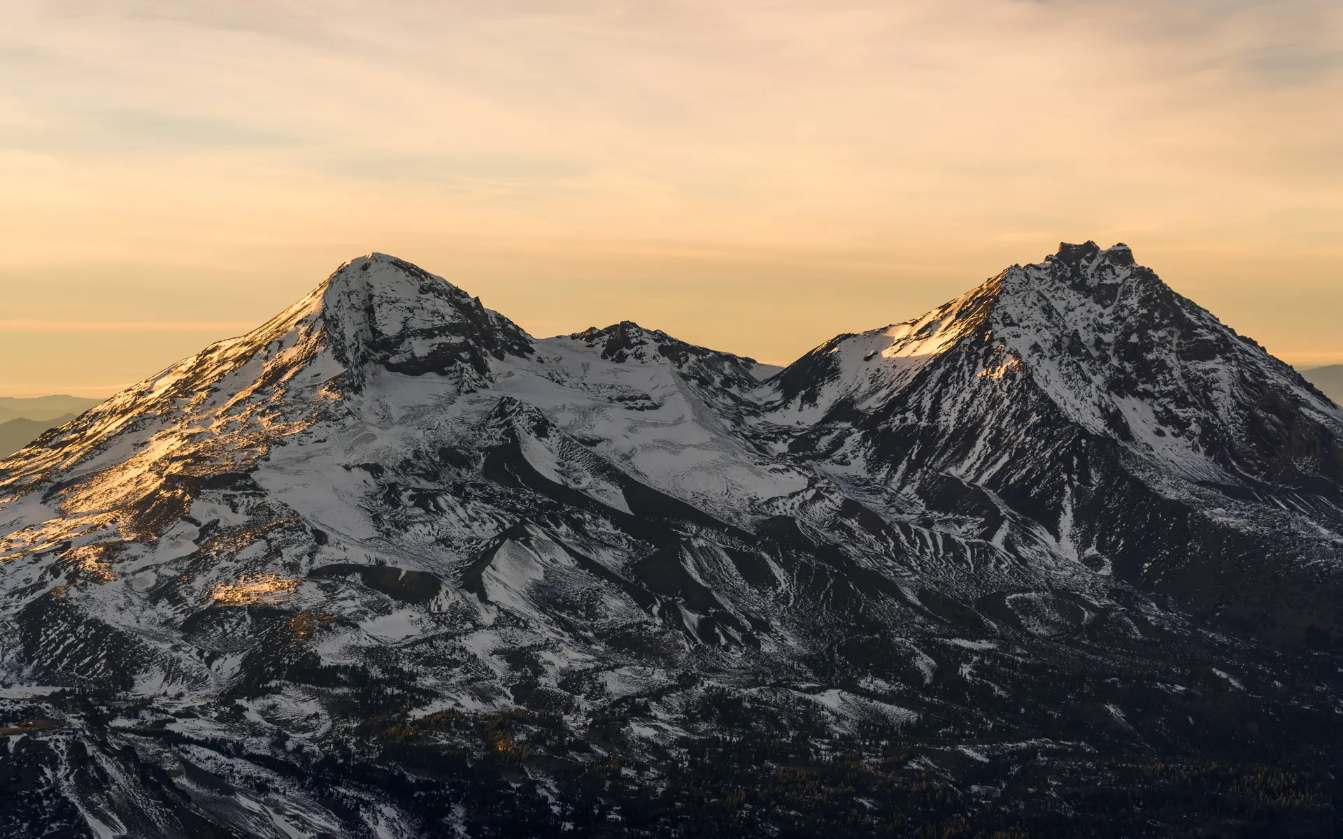
Lassen Volcanic National Park sits at the southern tip of the Cascade Range in northern California, and it is one of the few places on Earth with all four types of volcano: plug dome, shield, cinder cone, and composite. Lassen Peak itself is a giant plug dome that erupted as recently as 1915, and the park is still very much alive, with boiling mudpots, steaming fumaroles, and hissing vents scattered across its hydrothermal basins.
This 2-day route is built around Lassen Volcanic day hikes: Bumpass Hell, the largest hydrothermal area in the park, with boardwalks over boiling mudpots and fumaroles; the strenuous Lassen Peak Trail to the 10,457-foot summit; Kings Creek Falls; and the steep Cinder Cone with the otherworldly Painted Dunes and Fantastic Lava Beds. Easy options like the Manzanita Lake loop and the roadside Sulphur Works round it out.
The best window is July through October. The Lassen Park Highway, the scenic road that climbs over the park, holds a heavy snowpack and usually does not fully open until roughly June or July, with some years even later. Around the hydrothermal areas, always stay on the boardwalks and marked trails: the ground can be thin and the water and mud are scalding.
In-park lodging is limited to the Manzanita Lake Camping Cabins, which book up fast for summer weekends, so reserve early. Otherwise base in the gateway towns of Mineral or Chester, or in Redding about an hour west. Confirm the Lassen Park Highway is fully open before you go, since snow can keep the high stretch closed into early summer.


The Park Highway · Bumpass Hell & Lassen Peak
Enter from the southwest at the Kohm Yah-mah-nee Visitor Center near Mineral and drive the Lassen Park Highway, the scenic road that climbs over the park past most of its big hydrothermal and volcanic sights. Start with the roadside Sulphur Works, a hissing, sulphur-smelling thermal area right beside the road, then hike Bumpass Hell (about 3 miles round trip), the largest hydrothermal area in the park, where boardwalks lead out over boiling mudpots and roaring fumaroles.
If you have the legs, take on the Lassen Peak Trail (about 5 miles round trip, around 2,000 feet of gain, strenuous) to the 10,457-foot summit of this plug dome volcano. The switchbacking climb tops out at a 360-degree view over the whole park and, on clear days, north to Mount Shasta. Start early, carry water and sun protection, and watch the weather, since storms build fast at altitude.
- ~3 mi RT · boardwalks over boiling mudpots & fumaroles · the largest hydrothermal area
- ~5 mi RT · ~2,000 ft · strenuous · 10,457 ft plug dome summit
- Roadside hydrothermal area · steam vents & boiling mud right by the road
- Stay near Mineral or in the parkManzanita Lake Camping Cabins in-park, or base in Mineral · books ahead
- Around every hydrothermal area, stay strictly on the boardwalks and marked trails. The crust can be thin and the water and mud are hot enough to cause severe burns.
- The Lassen Peak Trail gains about 2,000 feet in roughly 2.5 miles. Start early, carry plenty of water and sun protection, and turn around if storms build at the summit.
- The Lassen Park Highway holds heavy snow and often does not fully open until June or July. Confirm it is open the whole way before you plan a one-way drive across the park.
Lassen Peak Sulphur Works
Kings Creek Falls, the Cinder Cone & Manzanita Lake
Painted DunesManzanita LakeStart the day with Kings Creek Falls (about 2.3 miles round trip), a forested hike down to a tiered cascade in the heart of the park, then head to the far northeast corner for the park's most distinctive hike. The Cinder Cone Trail (about 4 miles round trip) climbs steeply through loose volcanic cinders to the rim of a textbook cinder cone, with the multicolored Painted Dunes and the black Fantastic Lava Beds spread out below.
Wind down at Manzanita Lake with the easy Manzanita Lake loop (about 1.8 miles round trip), a flat, family-friendly walk that delivers postcard reflections of Lassen Peak on still mornings and evenings. If you have extra energy, the nearby Echo and Bathtub Lakes or the longer Mill Creek Falls and Paradise Meadows hikes are easy add-ons. Getting home: Redding (RDD) is about an hour west, or Reno is roughly 2.5 hours southeast.
- ~2.3 mi RT · forested hike to a tiered cascade · go in the morning
- ~4 mi RT · steep loose cinders · Painted Dunes & Fantastic Lava Beds below
- ~1.8 mi RT · easy · flat loop with reflections of Lassen Peak
- Getting home: Redding or RenoRedding (RDD) ~1 hr · Reno ~2.5 hr · fuel up before the drive out
- The Cinder Cone climb is short but brutally steep in loose volcanic cinder, like walking up a sand dune. Take your time and wear shoes you do not mind filling with grit.
- Manzanita Lake gives the best mirror reflections of Lassen Peak on calm, windless mornings and evenings, so save the loop for first or last light.
- For easy add-ons, the nearby Echo and Bathtub Lakes, Mill Creek Falls (about 3.8 miles round trip), and Paradise Meadows are all good lower-key Lassen Volcanic day hikes.
Now build your Lassen trip.
You've seen both days. Open the free drag-and-drop planner and tune it for your dates, your pace, and whether you base in Mineral, Chester, or Redding.
What we actually learned in the park.
Stay on the boardwalks in thermal areas
Bumpass Hell, Sulphur Works, and the other hydrothermal areas sit over thin, unstable crust above boiling water and mud. Stay strictly on the boardwalks and marked trails, keep kids and pets close, and never step off, because the ground can give way and the water is scalding.
Go July through October
The high country is buried in snow much of the year. July through October is the reliable hiking window, with wildflowers in midsummer and crisp, quiet days in fall. Outside that window, expect closed trails, deep snowpack, and limited access.
Confirm the Lassen Park Highway is open
The scenic road that climbs over the park holds a heavy snowpack and often does not fully open until June or July, sometimes later. Check current road status before you go, since a closed high stretch means a long detour to reach the far side of the park.
Treat Lassen Peak as a real summit
The Lassen Peak Trail gains about 2,000 feet to a 10,457-foot summit. Start early, carry plenty of water and sun protection, pace yourself in the thin air, and watch for fast-building afternoon thunderstorms that can make the exposed switchbacks dangerous.
Pay the entrance fee or bring your pass
Lassen Volcanic charges about $30 per vehicle for a 7-day pass. The annual America the Beautiful pass ($80) also covers entry and pays off fast if you visit other national parks. Pay at the entrance station or online ahead of time.
Lodging is limited, so book early
In-park lodging is essentially the Manzanita Lake Camping Cabins, which fill quickly for summer weekends. Otherwise base in Mineral or Chester near the park, or in Redding about an hour west, and reserve campsites through recreation.gov well in advance.
Pack warm layers even in August
Most of the park sits above 8,000 feet, so even a midsummer trip can turn cold, windy, and raw, especially on the exposed Lassen Peak switchbacks and at dawn by the lakes. Bring a heavy fleece or a wind shell on top of your sun protection, no matter how warm Redding felt on the drive up.
Everything you'll actually want to know.
Ready to go? Get your
Lassen day-hike route.
Trailheads and mileages, the hydrothermal safety you need, in-park cabins, gateway towns, Park Highway timing, and drive times from Redding and Reno to hike Lassen the smart way.
Instant book · Free cancellation · Secure payment via Stripe
Know these trails yourself? Become a local guide and host free community hikes.


Planning this trip?
Save it, share it with your crew, or find travelers heading the same way.
What other travelers are saying
Be the first to leave a tip or question for the next traveler.
How was your experience?
Tell us what worked and what did not. It goes straight to Yulia and Margarita.