
Three Days Backpacking
the Canyonlands Needles
Three days of Needles District hiking in the remote southwest corner of Canyonlands: the Chesler Park Loop and Joint Trail, Druid Arch, Elephant Canyon, and the Confluence Overlook.
Free interactive planner · drag & reorder your days, add stops, map it in minutes
Build your own Needles trip, drag, reorder & map it.
Drag stops between days, swap the loops, and add your own trailheads and overlooks with the place search. The live map and trail miles recalculate as you go, and we'll warn you before you build a day no one finishes with the water they're carrying.
Opens a side panel · reorder days, add custom stops, see your route live
A maze of spires, slots & slickrock, far from the crowds.
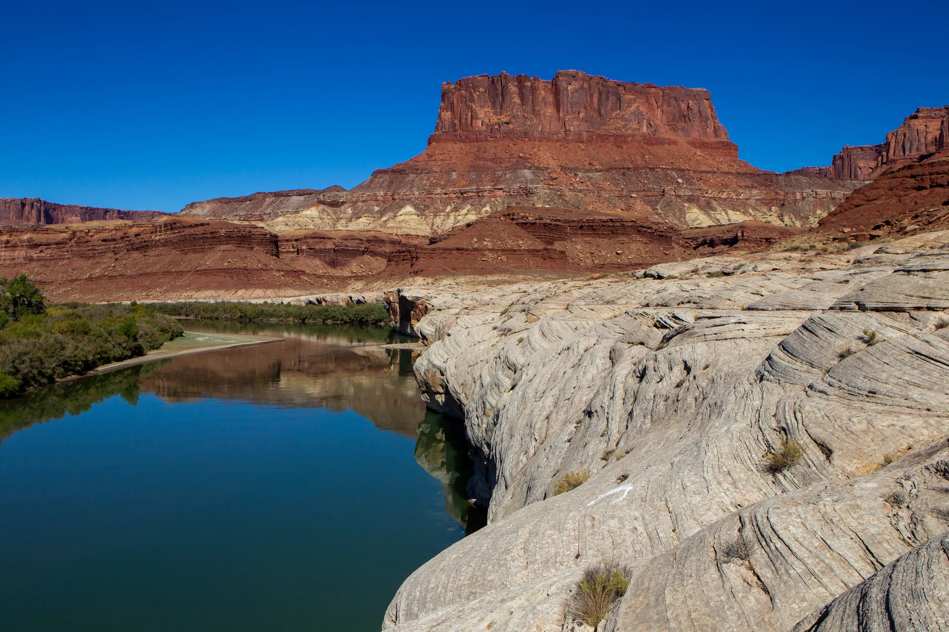
The Needles District is the hiker's corner of Canyonlands National Park, a remote sweep of country southwest of Moab named for the banded red-and-white sandstone spires that rise in clusters across it. It sits far from the busier Island in the Sky district, with its own entrance off Highway 211, and it rewards anyone willing to drive the extra hour with a labyrinth of canyons, meadows, and slickrock that most park visitors never reach.
This 3-day route is built around Canyonlands Needles backpacking: the iconic Chesler Park Loop with its spire-ringed meadow and the tight, dramatic Joint Trail slot, the strenuous climb up Elephant Canyon to the massive Druid Arch, and the long walk out to the Confluence Overlook where the Green and Colorado rivers meet. You'll mix overnight backcountry camping with classic day hikes off the Elephant Hill and Squaw Flat trailheads.
Spring and fall are the only sane seasons for Needles District hiking. Summer is dangerously hot, with little shade and almost no reliable water, and winter brings ice on the slickrock. Whenever you go, you must carry all your own water, because the springs here are seasonal and unreliable, and you must watch the sky for flash floods in the slots and washes.
Overnight trips in the Needles require a backcountry permit and a reserved camp zone, both through recreation.gov, and the popular zones go fast for spring and fall weekends, so book the moment your dates are set. There is no lodging and very little water inside the district, so base in Monticello or Moab, fill every bottle before you start, and bring far more water than you think you need.

Drive in & Cave Spring · the Chesler Park loop into camp
The Needles is a long way in: plan on about 75 miles and 90 minutes from Moab, the last stretch a beautiful run down Highway 211 past Newspaper Rock. Stop at the visitor center to pick up your permit, confirm conditions, and fill every bottle, then warm up your legs on the short Cave Spring loop (about 0.6 miles, with two wooden ladders), a quick introduction to the district's slickrock, alcoves, and an old cowboy camp.
In the afternoon, start the Chesler Park Loop from the Elephant Hill trailhead, climbing over slickrock into the heart of the district where the banded spires ring a wide desert meadow. Walk in to your reserved backcountry camp zone, set up before dark, and remember the golden rule of Canyonlands Needles backpacking: you carry every drop of your own water, because the springs out here are seasonal and not to be counted on.
- Drive in via Highway 211 & Newspaper Rock~75 mi / ~90 min from Moab · fill water at the visitor center
- ~0.6 mi · two ladders · slickrock, alcoves & a cowboy camp
- Spire-ringed meadow · from the Elephant Hill trailhead
- Overnight permit + zone required · carry all your water
- Fill every bottle and reservoir at the Needles visitor center before you start. There is no reliable water in the backcountry, and the springs are seasonal at best.
- The Elephant Hill trailhead road is rough but passable for most cars to the upper lot; the technical 4WD road beyond it is for high-clearance vehicles only.
- Pick up your backcountry permit and confirm your reserved camp zone at the visitor center, and ask a ranger about current water sources and flash-flood risk.
The Needles Needles country
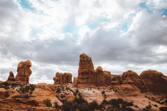
The Joint Trail & Druid Arch · a full day in the spires
Druid Arch Elephant Canyon
This is the big day. From camp, finish the Chesler Park Loop (about 11 miles all in) through its signature stretch, the Joint Trail, a series of deep, narrow fractures so tight you turn sideways, with a stone staircase wedged between sheer walls. It is the most photographed slot in the district and the reason many people come to the Needles at all.
If you have the legs and water, add the spur up Elephant Canyon to Druid Arch (about 11 miles round trip from the trailhead), a massive, angular arch that looks like a slab of Stonehenge standing at the canyon head, with a short ladder and slickrock scramble at the finish. Watch the time and the sky: the canyons funnel flash floods fast, and you want to be off the slickrock and back in camp well before dark.
- Narrow rock fractures + stone staircase · part of the Chesler Park Loop
- ~11 mi · spire meadow + the Joint Trail slot
- ~11 mi RT · ladder + slickrock scramble · a giant angular arch
- Same reserved zone · ration water carefully
- The Joint Trail squeezes through fractures barely wider than your shoulders; it is single-file and not for anyone uneasy in tight spaces, but it is the highlight of the district.
- Druid Arch and the Chesler Park loop both run through narrow canyons and washes. Check the forecast and turn back if storms threaten upstream, as flash floods arrive with little warning.
- There is almost no shade and no reliable water on these trails. Start at first light, carry at least 4 liters per person for a big day, and turn around in time to reach camp before dark.
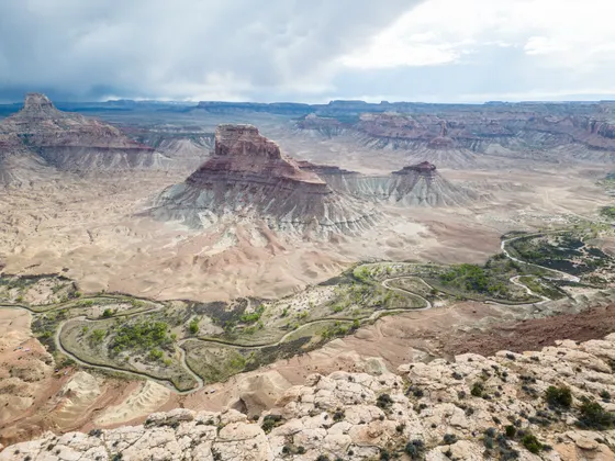
The Confluence Overlook & the drive out
Pack up camp and walk out to the Confluence Overlook (about 10 miles round trip from the Elephant Hill area), a mostly level desert traverse that ends at a dramatic cliff edge a thousand feet above the spot where the Green and Colorado rivers meet, the two great rivers that carved all of Canyonlands. The two waters run side by side in different colors before they merge, a fitting finale to the trip.
When you reach the trailhead, drive back out the way you came. Getting home: it is roughly 90 minutes to Moab and its airport (CNY), or about 2.5 hours to Grand Junction, Colorado (GJT) for more flights. Top off your tank in Monticello or Moab before any long stretch, and start the drive out with daylight to spare, since the road in and out of the district is remote and empty.
- ~10 mi RT · level traverse · the Green & Colorado rivers meet
- Where two rivers mergeA thousand feet above the confluence · the heart of Canyonlands
- Getting home: Moab or Grand JunctionMoab (CNY) ~90 min · Grand Junction (GJT) ~2.5 hr · fuel up first
- The Confluence Overlook trail is long but relatively flat, with rolling slickrock and no shade. Carry plenty of water for the full round trip, because there is none along the way.
- There is no railing at the overlook and the drop is sheer, so keep well back from the edge, especially with kids or in wind.
- The drive out is remote with little to no cell service. Top off your gas in Monticello or Moab, and leave with enough daylight for the 90-minute to 2.5-hour airport run.
 Slickrock route
 Needles sunset
Now build your Needles trip.
You've seen all three days. Open the free drag-and-drop planner and tune it for your dates, your pace, your permit zone, and whether you base in Monticello or Moab on the way in.
What we actually learned in the spires.
Get the backcountry permit early
Every overnight trip in the Needles requires a backcountry permit and a reserved camp zone through recreation.gov. The popular zones sell out for spring and fall weekends, so reserve the moment your dates are firm. Day hiking does not need a permit, but you still pay the park entrance fee.
Carry every drop of your water
The Needles is brutally dry, with little shade and almost no reliable water. The springs are seasonal and not to be counted on. Carry at least a gallon per person per day, fill up at the visitor center, and ask a ranger about current sources before you head out.
Go in spring or fall
Spring and fall bring comfortable days and cool nights, the only sane seasons for hiking here. Summer is dangerous, with temperatures topping 100°F and no shade, while winter brings ice on the slickrock. Whenever you go, start early and rest in the heat of the day.
Mind the flash-flood risk
The canyons, slots, and washes here funnel flash floods fast, often from storms you cannot see upstream. Check the forecast, avoid the narrows when rain threatens, and never camp in a wash. If water starts rising, get to high ground immediately.
Know the 4WD roads
Most trailheads, including Elephant Hill, are reachable by regular cars on rough but passable roads. The technical 4WD road beyond Elephant Hill is for experienced drivers in high-clearance vehicles only. Check road conditions at the visitor center before relying on any backcountry route.
Base in Monticello or Moab
There is no lodging inside the district. Monticello is the closest town to the south, and Moab is about 90 minutes north with far more options. Squaw Flat Campground inside the park is bookable through recreation.gov and fills fast in peak season.
Weigh your water and cook by the cup
Water is the heaviest thing you carry out here. A gallon per person per day runs about 8.3 pounds, so a two-night trip means real weight from the first step. Pack a rigid measuring cup and add only the water your dehydrated meals actually need, so you do not boil away drinking water at dinner when there is none to refill.
Cache water instead of hauling it over slickrock
If your permit zone allows hub-and-spoke camping, cache a sealed, clearly labeled jug of water at the Elephant Hill junction on your way in. That keeps you from carrying your Day 3 water up and over the Day 2 slickrock. Never count on a cache you did not place yourself, and pack out the empty container when you leave.
Everything you'll actually want to know.
Ready to go? Get your
Needles backpacking route.
Trailheads and mileages, the backcountry permit and camp zones, water strategy, 4WD road notes, and drive times from Moab and Grand Junction you need to backpack the Needles safely.
Instant book · Free cancellation · Secure payment via Stripe
Know these trails yourself? Become a local guide and host free community hikes.


Planning this trip?
Save it, share it with your crew, or find travelers heading the same way.
What other travelers are saying
Be the first to leave a tip or question for the next traveler.
How was your experience?
Tell us what worked and what did not. It goes straight to Yulia and Margarita.