The Gorge in Context
The Columbia River Gorge is a 80-mile stretch where the Columbia River cuts through the Cascade Range, creating a landscape of basalt cliffs, tiered waterfalls, and wildflower-covered slopes on both the Oregon and Washington sides. It's the only sea-level crossing of the Cascades and the result is dramatic: moist western conditions on the Oregon side, drier eastern conditions just 30 miles away. The contrast produces extraordinary botanical diversity, dozens of wildflower species unique to the Gorge bloom in April and May.
The Oregon side has the Historic Columbia River Highway (US-30), which was built between 1913 and 1922 specifically to provide access to the waterfalls. Many of the best waterfalls hikes start from the highway's many trailhead pullouts. The Washington side across the river is less visited and has some of the best strenuous hiking in the Gorge, Dog Mountain in particular is legendary for its April wildflower display.
The Best Hikes, Ranked by What You're Looking For
Best Waterfall: Multnomah Falls (2.4 miles, 700 ft gain)
Multnomah Falls is the second-tallest year-round waterfall in the US at 620 feet. The viewpoint at the base is one of the most photographed spots in Oregon. The trail climbs steeply on a paved path to a bridge partway up the falls, then continues to the top. Bring your patience, this is the most visited natural site in Oregon, with 2+ million visitors per year. The parking situation is managed via timed-entry permits from late March through October (book at recreation.gov). Alternatively, take the Columbia Gorge Express bus from Gateway/Transit Center in Portland, it runs frequently and eliminates the parking problem entirely.
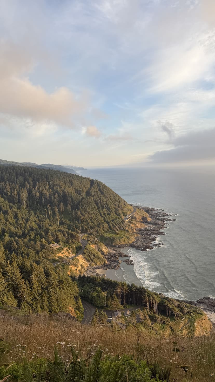
Best Sunset View: Angel's Rest (4.5 miles round trip, 1,500 ft gain)
Angel's Rest is the prototypical Gorge viewpoint hike: a relentlessly steep climb through forest ending at a rocky summit with panoramic views of the Gorge in both directions. The Columbia River, Crown Point's Vista House, and the Washington hills all spread out below. Sunset here in fall is extraordinary. The trailhead is at Bridal Veil, about 5 miles east of Multnomah Falls on US-30. No permit required but parking fills on weekends, arrive early or take the Express bus to Multnomah Falls and hike west on the Gorge Trail to connect.
Best Wildflowers: Dog Mountain (7.4 miles round trip, 2,800 ft gain), Washington Side
Dog Mountain is the wildflower hike in the Pacific Northwest. In late April and May, the open summit meadows are carpeted with balsamroot, lupine, and phlox, a display that draws hikers from across the region. The hike is strenuous: 2,800 feet of gain over 3.7 miles on a hot, exposed hillside on the Washington side of the Columbia. A recreation.gov permit is required on weekends from April through Junebook early, these sell out fast. Weekday permits are available closer to the date. The trailhead is on WA-14 east of White Salmon.
Best for Families: Latourell Falls (2.3 miles loop, 400 ft gain)
Latourell Falls is an underrated alternative to Multnomah, a 249-foot basalt-framed waterfall accessible in about 10 minutes from the parking area, with a 2.3-mile loop that passes a second upper falls. Less crowded than Multnomah, no permit required (though the parking area fills on weekends), and the short distance makes it ideal for families and less-experienced hikers. The trailhead is on US-30 just west of Multnomah.
Best All-Around Hike: Hamilton Mountain (8.2 miles round trip, 2,000 ft gain), Washington Side
Hamilton Mountain is on the Washington side in Beacon Rock State Park, and it's one of the best hikes in the Gorge that most Oregon-based hikers overlook. The route passes Hardy Falls and Pool of the Winds (a dramatic slot gorge with a roaring waterfall), climbs through forest to open ridgeline, and reaches a summit at 2,438 feet with sweeping Gorge views including Beacon Rock directly below. Well-maintained trail, excellent views-to-effort ratio, less crowded than the Oregon side.
Best Epic Day: Eagle Creek to Tunnel Falls (12 miles round trip, 1,200 ft gain)
Eagle Creek Trail is the most iconic waterfall hike in the Gorge, 6 miles one-way through a narrow creek canyon past seven major waterfalls, culminating at Tunnel Falls, where the trail passes through a tunnel blasted behind a 120-foot waterfall. The trail involves exposed sections along cliff edges with cables bolted for safety. The trail was heavily damaged in the 2017 Eagle Creek Fire and has been partially rebuilt. Current access conditions change seasonally, check with the Columbia River Gorge National Scenic Area before planning. When fully open, it's exceptional. Permits are required for certain sections.
Gorge Waterfall Trail: A Self-Guided Tour
If you want to hit multiple waterfalls in a single day, the Historic Columbia River Highway Trail connects many of the eastern Gorge waterfalls via a multi-use path. You can park at the Cascade Locks Marine Park or take the Express bus and hike west, stopping at Horsetail Falls, Oneonta Gorge, Ainsworth State Park, and Multnomah Falls. This approach lets you string together 5–6 miles of trail with multiple waterfall viewpoints without moving your car.
Eagle Creek Fire and Trail Recovery
In September 2017, a teenager threw fireworks into the Gorge and started the Eagle Creek Fire, which burned 50,000 acres, including most of the vegetation on the Oregon side of the Gorge. The landscape is recovering, the standing dead trees are dramatic, the understory is regenerating, but many trails were closed for years and some sections remain restricted. Check fs.usda.gov/crgnsa for current trail status before visiting. Most major trails have reopened, but conditions vary.
When to Go
April–May: Peak wildflower season. Dog Mountain blooms late April through mid-May. Waterfalls run full from spring rains. The most spectacular conditions but also the most crowded.
June–August: Excellent hiking conditions, drier weather. Waterfalls run lower but are still beautiful. Dog Mountain permits still required in June. Heat can be intense on the Washington side in July and August, start early.
September–November: Fall color transforms the Gorge in October. Crowds thin dramatically after Labor Day. Rains return in November and waterfalls fill again.
December–March: Waterfalls are spectacular in winter with high flow. Many trails are open year-round. Ice and snow possible on higher elevation trails (Angel's Rest, Dog Mountain). The lower waterfall trails along US-30 are generally passable year-round.
Getting There from Portland
The western Gorge (Latourell, Bridal Veil, Multnomah) is 30–35 miles east of Portland on I-84. Take exit 28 for Bridal Veil (US-30 Historic Highway) or exit 31 for Multnomah Falls. For weekends April through October, use the Columbia Gorge Express bus from Gateway Transit Center, it's the best option for Multnomah Falls and connects to the Historic Highway.
For the Washington side (Dog Mountain, Hamilton Mountain): take I-84 east to the Bridge of the Gods crossing at Cascade Locks, then east on WA-14. Dog Mountain trailhead is about 12 miles east of the bridge. Hamilton Mountain is at Beacon Rock State Park, 2 miles east of the bridge.