Frank Church River of No Return Map +
10-Day Salmon River & Bighorn Crags Expedition
10-day Frank Church River of No Return Wilderness expedition. Raft the Main Salmon from Corn Creek, backpack the Bighorn Crags to Ship Island Lake, and fly out by bush plane, the largest contiguous wilderness in the Lower 48 in one trip from Salmon, Idaho.
Free interactive planner · drag & reorder your days, add stops, map it in minutes
Build your own Idaho expedition, drag, reorder & map it.
Drag stops between days, swap river camps and Crags lakes, and add your own trailheads and launch points with the place search. The live map and legs recalculate as you go, so you can tune the Main Salmon float and the Bighorn Crags backpack to your pace before you lose all contact with the outside world.
Opens a side panel · reorder days, add custom stops, see your route live
The largest wilderness in the Lower 48, river and high country in one trip.
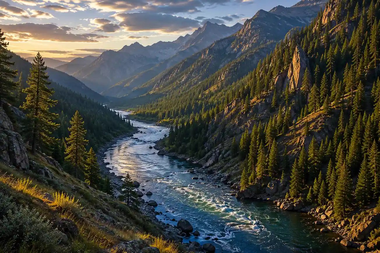
The Frank Church–River of No Return Wilderness, known simply as "The Frank," is the largest contiguous wilderness area in the Lower 48 states. This 10-day expedition combines exhilarating whitewater on the Main Salmon River, strenuous backpacking in the Bighorn Crags, and a bush-plane fly-in deep into roadless Idaho.
You stage in Salmon, Idaho, launch the Main Salmon at Corn Creek for 79 miles of Wild & Scenic river through Class III–IV rapids like Killum and Big Mallard, then trade paddles for a pack and climb into the granite spires of the Bighorn Crags to camp near Ship Island Lake.
This is an advanced trip: a competitive lottery permit is required to float the Main Salmon, a self-issued wilderness permit covers the Bighorn Crags, and you should be strong on both multi-day whitewater and high-elevation backpacking. Late June through August is the window; July balances good flows with melted-out high country.
The Main Salmon (Wild section, Corn Creek to Long Tom Bar) requires a permit for the controlled season of June 20 to September 7, allocated through a competitive lottery on Recreation.gov (apply December 1 to January 31). Bush-plane charters out of Salmon fill up in peak season, so book flights and shuttles once your dates are firm, or go with a commercial outfitter who handles permits, food, and logistics.
Arrive in Salmon, ID & Pre-Trip Briefing
Arrive in Salmon, Idaho, the gateway town for the Frank Church Wilderness. Salmon is about 4–5 hours from Boise (BOI) and 2.5–3 hours from Missoula (MSO). Spend the afternoon on last-minute gear checks and a mandatory pre-trip briefing with your outfitter covering safety, logistics, and the days ahead.
This is your last town for eight days, so check into your lodging early, top off supplies, and enjoy a real restaurant dinner. Confirm baggage weight limits for tomorrow's bush plane, because everything you bring has to fly in and out.
- Drive to Salmon, ID4–5 hr from Boise (BOI) · 2.5–3 hr from Missoula (MSO)
- Check into Salmon lodgingLimited motels & B&Bs · book well in advance
- Outfitter pre-trip briefing1–2 hr · safety, gear distribution, itinerary
- Salmon is small, with limited lodging and dining, so reserve a room and confirm your outfitter meeting time before you arrive.
- Weigh your dry bags and pack tonight, because bush planes have strict baggage-weight limits and charge for overages.
- Fill any prescriptions and buy last supplies here. There are no stores once you fly into the wilderness.
River of No ReturnTomorrow: fly inFly into the Wilderness & River Launch
River launchFirst milesTransfer to the Salmon airport for an early departure and fly deep into the Frank Church Wilderness by bush plane, an unmatched aerial view of the vast, roadless landscape. Land near the river, meet your guides, and rig the rafts for the Main Salmon.
After a full safety briefing, launch onto the "River of No Return" and paddle the first calmer miles to get comfortable with the boats and the current. Camp on a sandy beach and settle into the rhythm of wilderness river life.
- 30–60 min flight · scenic roadless landscape
- Rig rafts · safety briefing · permit required
- Riverside beach campPrimitive sandy-beach camp · Leave No Trace
- Bush pilots weigh passengers and gear, so keep your dry bags within the charter's limits and pack the day's essentials on top.
- Listen closely to the guide safety briefing: paddle commands, swimmer position, and what to do in a rapid keep everyone safe for the week.
- All river camps are primitive. Pack out everything, use the outfitter's groover and WAG-bag system, and follow Leave No Trace from day one.
Whitewater on the Main Salmon
After breakfast, continue downstream into bigger water. Run Killum Rapid (Class III) and a string of lively wave trains, then pull over to explore riverside homesteads and mining relics that tell the story of the hardy settlers who lived here.
Enjoy a fresh riverside lunch, keep watch for bighorn sheep and deer on the banks as the canyon walls rise, and make camp at another pristine beach. Class II–III rapids keep the afternoon active without the intensity of the big drops to come.
- Killum Rapid & morning whitewater10–15 mi · Class III · active paddling
- Historic homestead & mining sitesShort stops · interpretive talks from guides
- Riverside beach campNew camp · hearty guide-cooked dinner
- Rig for the day: strap down dry bags, clip your water bottle, and keep sun layers and a rain shell within reach as the canyon weather shifts.
- The Main Salmon has rich human history. Take the short walks to homesteads and mining sites, they are a highlight beyond the whitewater.
- Keep binoculars handy. The lower canyon is prime habitat for bighorn sheep, deer, and bald eagles.
Canyon walls riseClass II–IIIBig Mallard & River Immersion
Big MallardHot-spring soakToday brings Big Mallard Rapid (Class III–IV), one of the more significant drops on the Main Salmon, as the river carves into its deepest canyon sections and the sense of remoteness peaks. Guides read and run the biggest hydraulics of the trip.
Break from the boats for a side hike to a hidden waterfall or a natural hot spring, then float mixed rapids and calm pools while guides share the ecology, geology, and conservation story of The Frank. Camp again on a quiet beach.
- Big Mallard Rapid & deep canyon12–18 mi · Class III–IV · biggest water
- Side hike to waterfall or hot spring1–3 mi RT · stretch legs, cool off, soak
- Riverside beach campRemote camp · prep for the transition ahead
- Big Mallard is the trip's marquee rapid. Follow your guide's line and high-side commands exactly through the biggest hydraulics.
- Bring quick-dry footwear you can hike in. The best side attractions, waterfalls and hot springs, are short scrambles off the river.
- Hydrate hard. Long sunny days in the canyon dehydrate you faster than the cool water suggests.
Off the River & Base Camp for the Crags
Run the final, calmer river miles and reach the takeout, then transfer to a base camp near the Bighorn Crags trailhead at Crags Campground (elevation ~8,400 ft). Offload river gear, separate your backpacking kit, and repack for the high country.
Enjoy a hearty base-camp dinner and an outfitter briefing on trail conditions, water sources, and bear safety. Tomorrow trades the river for granite, so hydrate, sort your pack, and rest before the strenuous climb into the Crags.
- Final rafting section & takeout5–10 mi · Class II · relaxed river finish
- Transfer to Bighorn Crags base campCrags Campground trailhead · ~8,400 ft
- Establish base camp & repackConsolidate backpacking gear · hearty dinner
- Repack deliberately: pull only what you need for the backpack and stow river gear separately for the flight out.
- The Crags trailhead sits near 8,400 ft, so expect cool nights and thinner air even before you start climbing.
- Fill and treat water at base camp and study the route with your guide, high-country water sources can be spread out.
River takeoutHigh country aheadBackpack into the Bighorn Crags
The climb inHigh campSelf-issue your wilderness permit at the trailhead kiosk, then begin the strenuous climb into the Bighorn Crags on the main Crags trail: roughly 6–8 miles with 2,000–3,000 ft of gain through forested valleys that open onto exposed, rocky terrain.
Push on to a high-elevation camp near an alpine lake such as Ship Island Lake, the largest lake in the Crags at about 7,841 ft, ringed by granite. Filter water, pitch tents, store food in a bear canister, and settle in above 8,000 ft under a dark, star-filled sky.
- Trailhead kiosk · no quota · no fee
- Ascend the Bighorn Crags trail6–8 mi · 2,000–3,000 ft gain · strenuous
- High camp near Ship Island LakeAlpine lake ~7,841 ft · bear canister required
- Fill out the self-issue permit accurately, it is free, has no quota, and helps the Forest Service with safety and use data.
- Pace the climb and carry plenty of water. The trail gains 2,000–3,000 ft and water sources thin out on the exposed sections.
- A bear canister or Ursack is mandatory for food storage at high camp, and it keeps rodents out too.
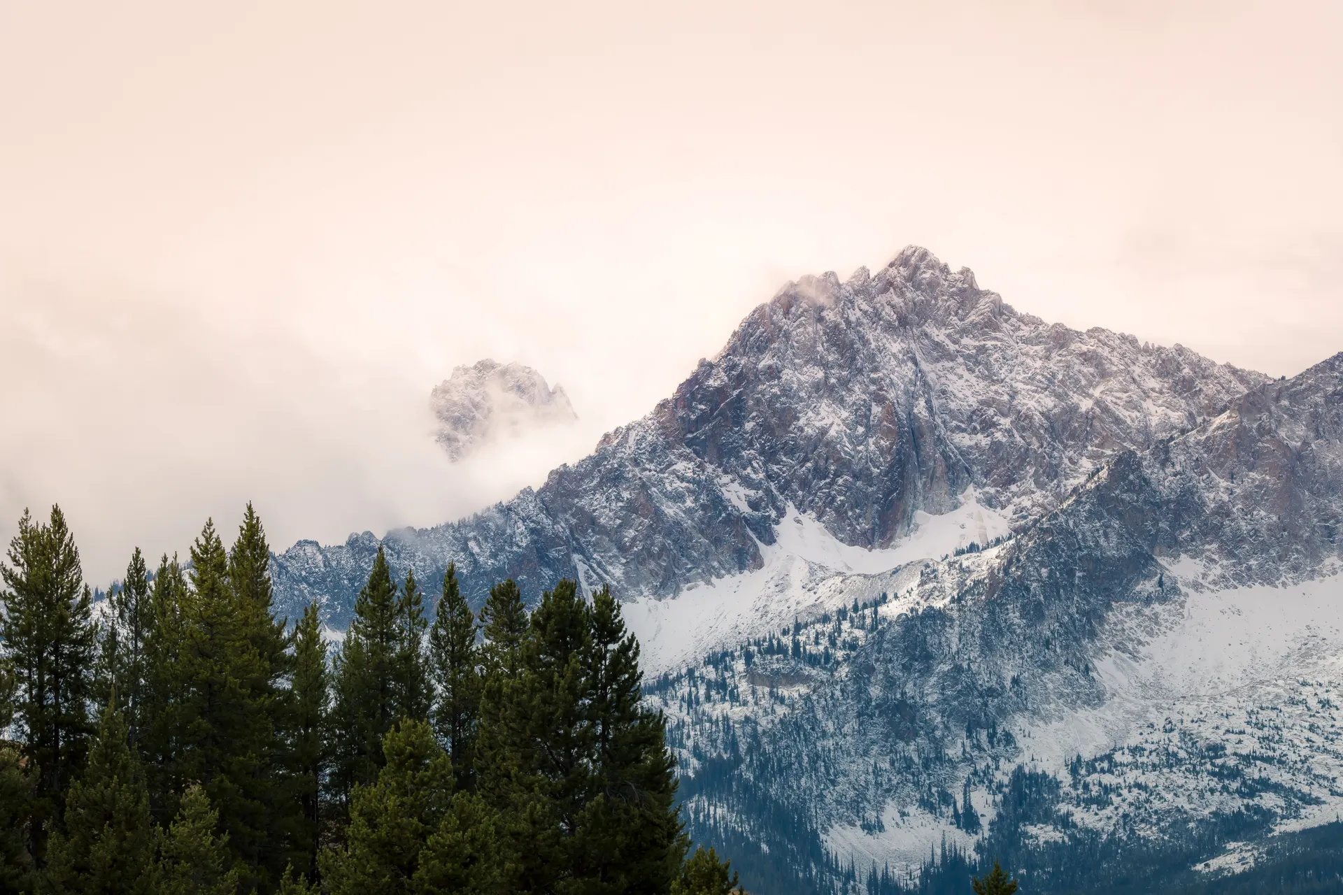
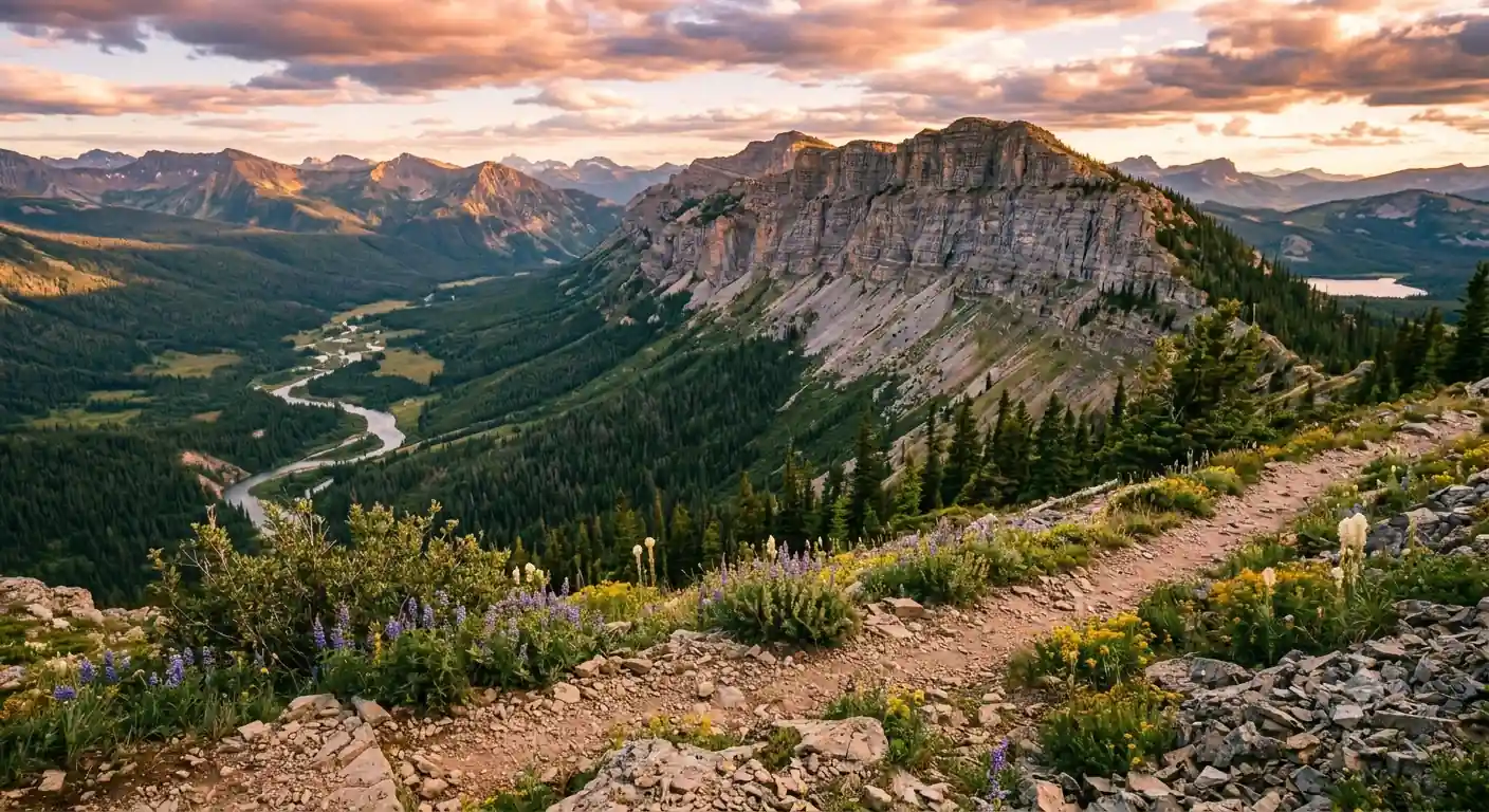
Exploring the Bighorn Crags High Country
A layover day to explore the dramatic granite spires and glacial cirques without moving camp. Day-hike to Ship Island Lake and the surrounding basins beneath towering peaks, watching for pika, marmots, and mountain goats among the rocks.
Stronger hikers can scramble a ridge or minor peak, such as the shoulders below Mount McGuire (the high point of the Crags at ~10,082 ft), for panoramic views across The Frank. This acclimatization day is the trip's photographic and emotional high point.
- 3–5 mi RT · granite basins & alpine lakes
- Ridge scramble below Mount McGuireOff-trail · panoramic Frank Church views
- Wildlife & photographyMountain goats, pika, marmots · dark skies
- Carry a daypack with the ten essentials even on a "rest" day, weather in the Crags turns fast at elevation.
- Off-trail ridge scrambles need solid route-finding and good footing, turn back if the weather builds.
- This is the best wildlife and photography day. Keep a respectful distance from mountain goats and never feed them.
Ship Island LakeRidge viewsDescend the Crags to Base Camp
Leaving high campBack at base campPack up high camp and begin the 6–8 mile descent (2,000–3,000 ft of loss) back toward the trailhead, watching the landscape shift from alpine granite through subalpine forest to the lower valleys. Trekking poles save your knees on the steep sections.
Reach the base camp near the trailhead, shed the heavy pack, and enjoy the relative comfort of a lower, less primitive camp. Celebrate finishing the backpacking segment with a hearty dinner and swap stories before tomorrow's flight out.
- Descend from high camp6–8 mi · 2,000–3,000 ft loss · use poles
- Through the vegetation zonesAlpine to subalpine forest to valley
- Final night at base campCelebratory dinner · last wilderness night
- Use trekking poles on the descent, 2,000–3,000 ft of downhill is hard on knees after two nights up high.
- Check your feet at lunch for hot spots and tape them before they become blisters on the way down.
- Do a final Leave No Trace sweep of high camp before you leave, pack out every scrap.
Bush Plane Return to Salmon, ID
Pack up base camp with a final Leave No Trace sweep and prepare for the bush-plane flight back to Salmon. From the air you trace the river and mountains you just crossed, a fitting last look at the roadless heart of The Frank.
Back in Salmon, transfer to your accommodation for a hot shower and a real bed, then gather for a celebratory dinner in town to toast a successful expedition and thank your guides.
- 30–60 min · aerial view of the wilderness
- Transfer to Salmon lodgingHot shower · real bed · unpack gear
- Celebratory dinner in SalmonLocal restaurant · thank the guides
- Weather can delay bush flights, so keep your schedule flexible and don't book tight airport connections for the next day.
- Have cash on hand for guide gratuities, it is customary and appreciated after a long expedition.
- Reconfirm your Salmon lodging for tonight before you fly out, in case plans shifted during the trip.
One last lookBack in SalmonDeparture from Salmon, ID
Salmon RiverUntil next timeEnjoy a leisurely breakfast in Salmon and a final gathering with your group before you head home. This is your last chance for local cuisine and to swap contact info with the people you shared the wilderness with.
Arrange a shuttle to Boise (BOI) or Missoula (MSO), allow ample time for the mountain drive, and depart Idaho, or extend your trip with a stop in the Sawtooths or Bitterroots on the way out.
- Breakfast & farewell in SalmonHotel or local cafe · last group meal
- Shuttle to Boise or Missoula airport4–5 hr to BOI · 2.5–3 hr to MSO
- Book your flight home for the afternoon or next day, the drive from Salmon to either airport is long and mountainous.
- Missoula (MSO) is the shorter drive at 2.5–3 hours if you have a choice of arrival and departure airports.
- Consider a buffer day in Salmon or the Sawtooths in case bush-plane weather pushes your return.
Now build your Frank Church expedition.
You've seen all ten days. Open the free drag-and-drop planner and tune it for your dates, your outfitter, and how many days you want on the river versus in the Bighorn Crags high country.
Essential permits, gear & wilderness planning.
Main Salmon permit lottery
A permit is required to float the Wild section of the Main Salmon (Corn Creek to Long Tom Bar) during the controlled season, June 20 to September 7. Permits are allocated by competitive lottery on Recreation.gov, with applications December 1 to January 31. A maximum of eight float parties launch per day. Outfitters carry permits for commercial trips.
Bighorn Crags permit
Wilderness permits for backpacking the Bighorn Crags are self-issued at the trailhead kiosk, with no quota and no fee. Fill it out accurately for safety and use data. Always check the Salmon-Challis National Forest website for current regulations before your trip.
Bush plane charters
Bush planes are the practical way into this roadless wilderness. Book early for peak season with operators out of Salmon such as Salmon Air. Prices depend on passenger count and gear weight, so expect several hundred dollars per person round trip, and weigh your dry bags before you fly.
Leave No Trace & food storage
Pack out everything you pack in. On the river use the outfitter groover and WAG-bag system; in the backcountry dig catholes and carry a bear canister or Ursack. Camp only in durable, established sites and minimize impact throughout The Frank.
Go late June through August
July is the sweet spot: good river flows, warm weather, and melted-out high country. June brings bigger, colder whitewater and lingering snow in the Crags; August has lower flows and can carry wildfire smoke. Always check current flows and forecasts before you go.
This is an advanced trip
You combine multi-day Class III–IV rafting with strenuous backpacking above 8,000 ft. Come in excellent shape with prior experience in both, or go with a commercial outfitter who provides guides, food, gear, and handles the permits and bush-plane logistics.
Everything you'll actually want to know.
Ready to go? Get your
Frank Church River of No Return route.
The Main Salmon lottery and Corn Creek launch, the self-issued Bighorn Crags permit, bush-plane charters out of Salmon, drive times from Boise and Missoula, and the July timing that lines up good river flows with melted-out high country.
Instant book · Free cancellation · Secure payment via Stripe

Planning this trip?
Save it, share it with your crew, or find travelers heading the same way.

Liked this itinerary?
What other travelers are saying
Be the first to leave a tip or question for the next traveler.