
Two Days Among
the Bryce Hoodoos
A 2-day Bryce Canyon itinerary built around the Navajo Loop and Queen's Garden combo, the Amphitheater rim viewpoints, the scenic drive to Rainbow Point, and some of the darkest skies in the country.
Free interactive planner · drag & reorder your days, add stops, map it in minutes
Build your own Bryce Canyon trip, drag, reorder & map it.
Drag stops between days, swap the hike for the easy Rim Trail, and add your own viewpoints with the place search. The live map and drive times recalculate as you go, and we'll remind you that everything here sits above 8,000 feet, so pace yourself for the altitude.
Opens a side panel · reorder days, add custom stops, see your route live
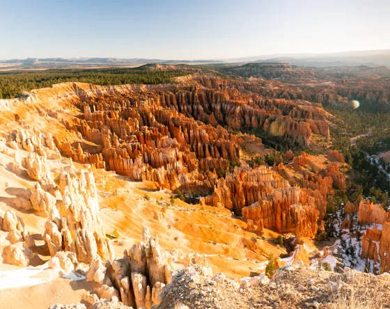
One amphitheater, thousands of hoodoos, all in southern Utah.
Bryce Canyon is not really a canyon at all but a series of natural amphitheaters carved into the edge of the Paunsaugunt Plateau, filled with thousands of hoodoos, the slender orange spires that make this the strangest skyline in the national park system. It is small, walkable, and concentrated, which makes it perfect for a focused two-day trip.
This 2-day itinerary is built around the classic Navajo Loop and Queen's Garden combo (about 2.9 miles), the must-do hike that descends the Wall Street switchbacks and winds you right through the hoodoos before climbing back to the rim. You'll pair it with the Amphitheater rim viewpoints, the 18-mile scenic drive to Rainbow Point, and a night under some of the darkest skies in the country.
A big thing to plan for: elevation. The rim sits between roughly 8,000 and 9,100 feet, so mornings are cold, snow can linger into spring, afternoon thunderstorms build in summer, and you will feel the thin air on every climb. Take the first day easy, drink plenty of water, and save the steep hikes for when you have acclimatized a little.
The Lodge at Bryce Canyon is the only in-park lodging and is concessioner-run, so book it directly and far ahead for summer dates. If it is full, base in Bryce Canyon City just outside the entrance or in Tropic down on Highway 12. The park sits at high elevation, so pack layers even in summer, and plan for cold mornings and possible afternoon storms.


The rim viewpoints & the Navajo Loop + Queen's Garden
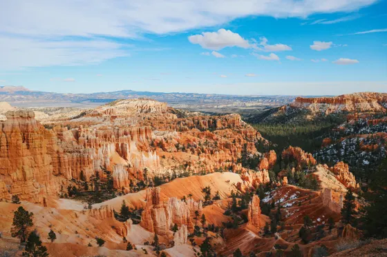
Start at the heart of the park, the Bryce Amphitheater, and walk the easy stretch of the Rim Trail from Sunrise Point to Sunset Point (about 1 mile), looking down on a sea of hoodoos. From Sunset Point you can pick out Thor's Hammer, the single most photographed hoodoo in the park, perched right below the rim.
Then drop in for the must-do hike: the Navajo Loop and Queen's Garden combo (about 2.9 miles), the classic Bryce loop. Descend the dramatic Wall Street switchbacks between towering rock walls, wind through the hoodoos on the canyon floor, and climb back out past Queen's Garden to the rim. Take it slow: you are above 8,000 feet, so the climb back up feels harder than the mileage suggests.
- ~1 mi · easy · the best overview of the amphitheater
- ~2.9 mi · moderate · Wall Street switchbacks · the must-do hike
- Thor's Hammer from Sunset PointThe park's iconic hoodoo · just below the rim
- Stay near the AmphitheaterThe Lodge at Bryce Canyon or nearby Bryce Canyon City
- Hike the Navajo Loop and Queen's Garden as a loop by going down Wall Street and back up Queen's Garden, the gentler way to climb out at altitude.
- Wall Street can stay closed into late spring or after storms because of ice and rockfall. If it is shut, descend the Two Bridges side of the Navajo Loop instead.
- You are above 8,000 feet here. Drink more water than usual, take the climbs slowly, and give yourself a day to adjust if you came up from low elevation.
Wall StreetThor's HammerSunrise at Bryce Point, the scenic drive & dark skies
 Rainbow Point
 Dark skies
Set an early alarm for sunrise at Bryce Point or Inspiration Point, where the first light hits the amphitheater and the hoodoos glow orange and pink from the top down. These higher viewpoints, along with Sunrise Point and Inspiration Point, give you the widest sweep over the whole bowl of spires.
Then drive the 18-mile scenic drive out to the far southern end of the park, stopping at the overlooks along the way: Natural Bridge (a huge rock arch glowing against the green forest), Agua Canyon, and finally Rainbow Point at about 9,100 feet, the highest point in the park. Since it is one road in and out, it is easiest to drive all the way to Rainbow Point first and stop at the viewpoints on the way back.
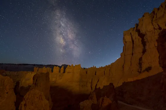
If you have an extra half day, add the quieter Fairyland Loop (about 8 miles) or the easy Mossy Cave Trail (about 0.8 miles) off Highway 12. Stay up for the stars: Bryce is a certified Dark Sky park and famous for astronomy, so on a clear night the Milky Way over the hoodoos is unforgettable.
- First light on the amphitheater · dress warm · go early
- Natural Bridge, Agua Canyon · Rainbow Point ~9,100 ft
- Fairyland ~8 mi quieter · Mossy Cave ~0.8 mi off Hwy 12
- Stargazing · Dark Sky parkCertified Dark Sky park · famous for astronomy · clear nights
- It is one road to the far end of the park, so drive straight to Rainbow Point first and hit Agua Canyon, Natural Bridge, and the other overlooks on the way back when they are on the right side of the road.
- Afternoon thunderstorms build fast in summer at this elevation. Do your rim walks and the scenic drive in the morning, and get off exposed viewpoints if storms roll in.
- Bryce is a certified Dark Sky park. Check whether the park or a nearby outfitter is running an astronomy or full-moon program during your dates, and bring a red flashlight to protect your night vision.
Now build your Bryce Canyon trip.
You've seen both days. Open the free drag-and-drop planner and tune it for your dates, your pace, and whether you base in Bryce Canyon City, Tropic, or the in-park lodge.
What we actually learned on the rim.
Pay the entrance fee or bring your pass
Bryce Canyon charges about $35 per vehicle for a 7-day pass. The annual America the Beautiful pass ($80) also covers entry and pays off fast if you visit Zion, the Grand Canyon, or other parks on the same trip. Pay at the entrance station or online ahead of time.
Plan for high elevation
The rim sits between roughly 8,000 and 9,100 feet. Expect cold mornings even in summer, thinner air on every climb, and afternoon thunderstorms that build fast. Drink plenty of water, take the steep hikes slowly, and give yourself time to acclimatize if you came up from low elevation.
Drive the scenic road one way
The 18-mile scenic drive is a single road in and out. Drive all the way to Rainbow Point at the south end first, then stop at Natural Bridge, Agua Canyon, and the other overlooks on the way back, when they are on the right-hand side of the road for easy pull-ins.
Do the Figure-8 if you want more
The Navajo Loop and Queen's Garden combo (about 2.9 miles) is the must-do. If you want a bigger day among the hoodoos, link in the Peekaboo Loop (about 5.5 miles) to make the Figure-8, roughly 6.4 miles through the heart of the amphitheater.
Stay up for the stars
Bryce is a certified Dark Sky park and one of the best stargazing spots in the country. On a clear, moonless night the Milky Way arcs right over the hoodoos. Check for ranger astronomy programs, bring a red flashlight, and let your eyes adjust for at least twenty minutes.
Book lodging early
The Lodge at Bryce Canyon is the only in-park lodging, is concessioner-run, and books up far ahead for summer. If it is full, base in Bryce Canyon City just outside the entrance or in Tropic down on Highway 12, both a short drive from the Amphitheater.
Stock up on food and water before you arrive
Groceries in Bryce Canyon City are limited and tend to run pricey, so buy your trail lunches, snacks, and plenty of water back in Cedar City or Las Vegas on the way in. The dry, high-elevation air dehydrates you fast, so plan on carrying more water than you would at sea level for every walk among the hoodoos.
Everything you'll actually want to know.
Ready to go? Get your
Bryce Canyon itinerary.
Trailheads and mileages, the rim viewpoints, the scenic drive to Rainbow Point, the only in-park lodge, drive times from Las Vegas and Salt Lake City, and the altitude and weather timing you need to hike Bryce comfortably.
Instant book · Free cancellation · Secure payment via Stripe
Know these trails yourself? Become a local guide and host free community hikes.


Planning this trip?
Save it, share it with your crew, or find travelers heading the same way.
What other travelers are saying
Be the first to leave a tip or question for the next traveler.
How was your experience?
Tell us what worked and what did not. It goes straight to Yulia and Margarita.