Four Days in the
American Alps: North Cascades
Four days backpacking the North Cascades: Cascade Pass and the Sahale Arm to a glacier camp, the Maple Pass Loop, and the turquoise Diablo and Ross Lakes along Highway 20.
Free interactive planner · drag & reorder your days, add stops, map it in minutes
Don't just plan it. Hike it with a local.
Join Yulia's small-group guided hike in the Pacific Northwest. A local who knows every trail brings the gear, takes the photos, and shows you the spots most people walk right past.
Build your own North Cascades trip, drag, reorder & map it.
Drag stops between days, swap passes and lakes, and add your own trailheads and overlooks with the place search. The live map and drive times recalculate as you go, and we'll flag the long Highway 20 legs before you build a day you cannot finish in daylight.
Opens a side panel · reorder days, add custom stops, see your route live
The American Alps: glaciers, granite & turquoise lakes, all in Washington.
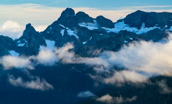
North Cascades National Park is the wildest and least-crowded of Washington's big parks, a rugged, glaciated range so jagged it earned the nickname the American Alps. It holds more glaciers than anywhere else in the lower 48, and yet it sees a fraction of the visitors of Rainier or Olympic, so the high passes and granite cirques can feel like they are yours alone.
This 4-day route is built around North Cascades backpacking: the classic climb over Cascade Pass and up the Sahale Arm to a jaw-dropping camp at the edge of the Sahale Glacier, the larch-lined Maple Pass Loop just over the park boundary, and the turquoise Diablo and Ross Lakes strung along the North Cascades Highway (State Route 20). You'll mix a glacier-edge overnight with day hikes, a Skagit River raft trip, and the most scenic drive in the state.
Late July through September is the prime window. Snow lingers on the high passes into July, biting bugs peak in midsummer, and the famous golden larches turn in late September. Highway 20, the only road through the park, closes in winter when the snow comes, so this is a summer-and-early-fall trip.
Backcountry camping in North Cascades National Park requires a wilderness permit, and the most popular sites, including Sahale Glacier Camp, go fast when reservations open on recreation.gov, so plan and book early. You must store food in a bear canister or hang it. Lodging is scarce out here, so base in Marblemount or Newhalem near the west entrance, or Winthrop on the dry east side, and fuel up before Highway 20.
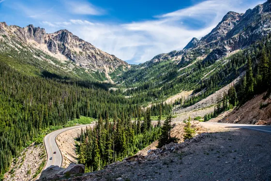
Drive Highway 20 in · Diablo Lake & permits in Marblemount
The North Cascades are surprisingly close to a major airport yet feel a world away. Plan on about 2.5 to 3 hours from Seattle (SEA) up the North Cascades Highway (State Route 20), the only road through the park. Stop at the Wilderness Information Center in Marblemount to pick up or confirm your overnight permit and check trail conditions, and fuel up here, because services thin out fast as you climb east.
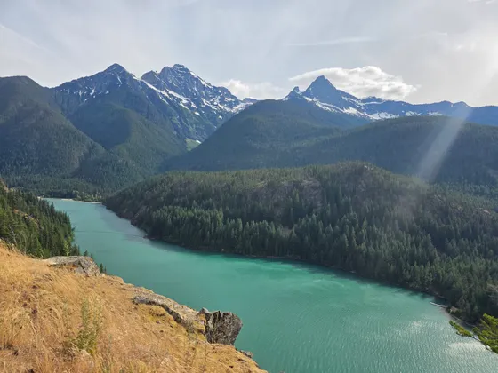
Spend the afternoon on the easy scenic highlights along the highway. Pull off at the Diablo Lake Overlook, where the reservoir glows an unreal turquoise from glacial rock flour, then walk a short trail near Newhalem or Gorge Creek Falls to stretch your legs. Settle in for the night near the west entrance so you are positioned for an early start at the Cascade Pass trailhead tomorrow.
- Pick up or confirm your overnight permit · check trail & snow conditions
- Turquoise glacier-fed reservoir · a quick stop on Highway 20
- Fuel up before Highway 20Services thin out east of Marblemount · top off your tank
- Stay in Marblemount or NewhalemNear the west entrance · positioned for the Cascade Pass trailhead
- A wilderness permit is required for any backcountry camping in the park. Reserve in advance on recreation.gov and confirm it at the Marblemount Wilderness Information Center before you head up.
- Highway 20 is the only road through the park and closes in winter for snow, usually reopening by late spring. Late July through September is the reliable window for the high passes.
- Fuel up and grab supplies in Marblemount. Gas and services are scarce as you climb east toward Diablo Lake and Washington Pass.
 Highway 20
 Newhalem gateway
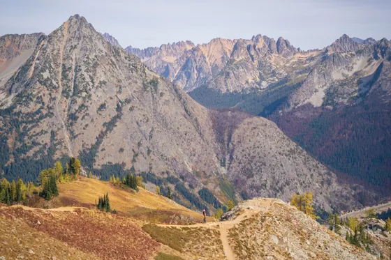
Cascade Pass & the Sahale Arm · camp at the glacier
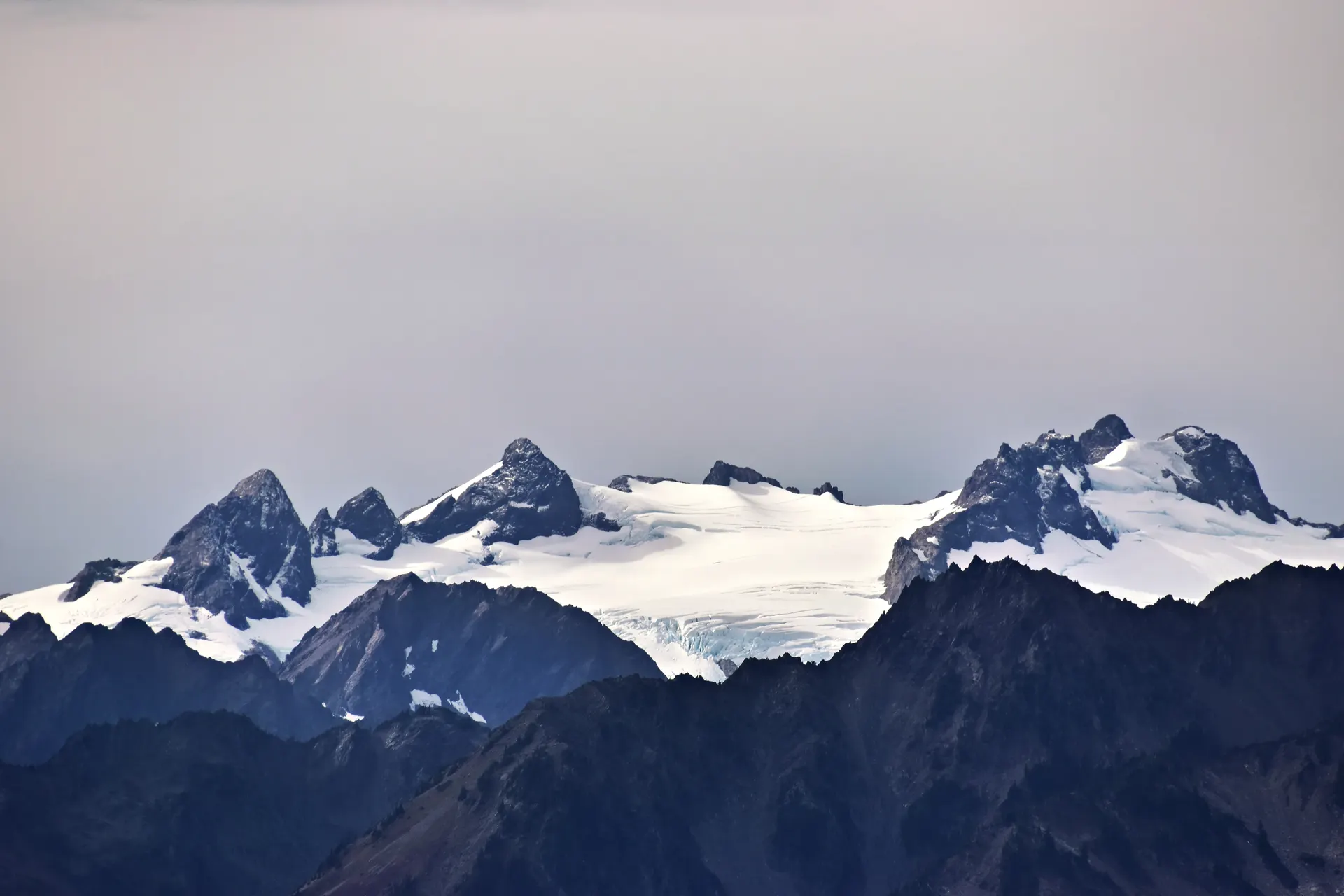
Cascade Pass Glacier camp
This is the centerpiece of the trip and one of the great backpacks in the lower 48. From the Cascade Pass trailhead, climb the famous switchbacks up to Cascade Pass (about 3.7 miles), where the whole jagged spine of the park unfolds around you. Then turn up the Sahale Arm, a ridgeline that keeps climbing through heather meadows toward the glaciers, roughly 12 miles round trip to the top.
Your destination is Sahale Glacier Camp, a cluster of rock-walled tent sites perched at the foot of the Sahale Glacier with a jaw-dropping panorama over the peaks and valleys below. It is one of the most spectacular places you can pitch a tent anywhere, and it requires a wilderness permit booked ahead. Carry a bear canister or hang your food, pack warm layers, and watch the weather, because conditions up here turn fast.
- ~12 mi RT to the top · strenuous · the park's signature climb
- Rock-walled sites at the glacier's edge · wilderness permit required
- Bear canister or food hangRequired food storage · pack warm layers and watch the weather
- Carry plenty of water & a filterSnowmelt sources higher up · the climb is long and exposed
- Sahale Glacier Camp is one of the most coveted backcountry sites in the park and books out fast. Reserve your wilderness permit on recreation.gov the moment your dates open.
- The Sahale Arm is steep, exposed, and high. Pack warm layers, rain gear, and a stove. Weather at the glacier edge can change quickly even in summer.
- Store all food and scented items in a bear canister or hang them. Snow can linger on the upper arm into July, so check conditions with the rangers in Marblemount.
Down to the lakes · a Skagit River raft trip
Pack up camp and descend the Sahale Arm and Cascade Pass back to the trailhead, savoring the views you climbed past in the other direction. Trade boots for a paddle and head down to the river for a guided Skagit River rafting trip with Triad River Tours, a scenic float through the forested valley below the peaks, a perfect rest-day reward for tired legs.
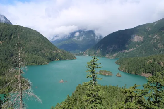
In the afternoon, explore the turquoise reservoir lakes strung along Highway 20. The glacier-fed Diablo Lake and the larger Ross Lake shimmer an electric blue-green, and short trails and overlooks near Newhalem and the Ross Dam give you the classic North Cascades postcard without a big climb. Resupply, do laundry, and recharge in town before tomorrow's drive over the high passes.
- Guided scenic float on the Skagit · book ahead · a great rest-day reward
- Turquoise reservoir lakes · short trails near Newhalem & Ross Dam
- Resupply in townLaundry, food, and a real bed before the high passes tomorrow
- Stay near the lakes or NewhalemRest legs, dry gear, and recharge after the glacier camp
- Triad River Tours runs guided rafting on the Skagit River near the park. Reserve ahead, especially on summer weekends, and make it a low-effort recovery day after the Sahale climb.
- Diablo and Ross are glacier-fed reservoirs, which is why they glow that turquoise color. The overlooks along Highway 20 give you the view with little to no hiking.
- Use this day to resupply, dry out wet gear, and recharge devices. Services are limited east of here, so stock up before the drive over Washington Pass.
 Skagit River raftDiablo Lake
The Maple Pass Loop · larches, lookouts & the drive home
 Larch season
 Hidden Lake Lookout
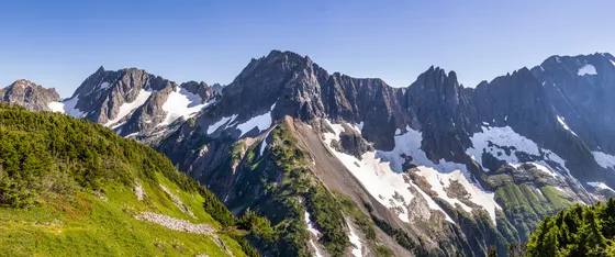
Finish with one of the best day hikes in the range, the Maple Pass Loop (about 7.2 miles, strenuous), which technically sits just outside the park boundary near Rainy Pass. It climbs through subalpine meadows past Lake Ann to a high pass with a sweeping ridgeline panorama, and in late September the slopes blaze gold as the larches turn, one of the great fall spectacles in Washington. If you have the legs and want fewer crowds, the steep Hidden Lake Lookout is a stunning alternative back near Marblemount.
Continue up to Washington Pass for the dramatic overlook above the highway hairpin, then begin the drive out. Getting home: from the Maple Pass / Rainy Pass area it is roughly 3 to 3.5 hours back to Seattle (SEA) the way you came, or you can drop east to Winthrop for the night and loop back another day. Top off your gas and start the drive with daylight, because Highway 20 is long, winding, and short on services.
- ~7.2 mi loop · strenuous · larches in late September · just outside the park
- Steep, stunning lookout near Marblemount · fewer crowds · rough access road
- Dramatic view over the Highway 20 hairpin · a quick stop
- Getting home: Seattle or WinthropSEA ~3 to 3.5 hr · or drop east to Winthrop for the night
- The Maple Pass Loop is best hiked clockwise to save the steepest section for the descent. Go in late September for the golden larches, but expect a full trailhead lot on fall weekends.
- Hidden Lake Lookout is a stunning, steep alternative near Marblemount, but the access road is rough and high-clearance is recommended. Check conditions before you commit.
- It is a long, winding drive back. Fill up before you leave the passes and start with plenty of daylight, since Highway 20 has few services and no reliable cell coverage.
Now build your North Cascades trip.
You've seen all four days. Open the free drag-and-drop planner and tune it for your dates, your pace, and whether you base in Marblemount, Newhalem, or Winthrop.
What we actually learned in the American Alps.
Get your wilderness permit early
Any overnight backcountry camping in North Cascades National Park requires a wilderness permit. The most popular sites, including Sahale Glacier Camp, sell out fast when reservations open on recreation.gov, so book the moment your dates are available and confirm at the Marblemount Wilderness Information Center.
Carry a bear canister or hang your food
You must store all food and scented items in an approved bear canister or hang it properly. Black bears are active across the range, and proper food storage protects both you and them. Rangers in Marblemount can advise on the requirements for your route.
Go late July through September
Snow lingers on the high passes into July, biting bugs peak in midsummer, and the famous golden larches turn in late September. Late summer into early fall is the sweet spot for the Sahale Arm, Maple Pass, and the high lookouts.
Highway 20 closes in winter
The North Cascades Highway (State Route 20) is the only road through the park and closes in winter for heavy snow, usually reopening by late spring. Check the road status before you go, fuel up early, and expect long stretches with no services east of Marblemount.
Expect little to no cell service
Cell coverage is spotty to nonexistent across most of the park. Download offline maps, screenshot your trailheads and permit details, and tell someone your plan and expected return before you head into the backcountry.
Respect the alpine weather
This is a high, glaciated range and conditions change fast. Even in summer, carry warm layers, rain gear, and traction if snow lingers. Start climbs early, watch the sky, and turn around if a storm builds on an exposed ridge like the Sahale Arm.
Check the access roads for washouts
The trailheads sit at the end of remote logging roads that can wash out after storms or stay blocked by lingering snowpack. Before you commit to the long drive up, verify current road and trail conditions with the rangers in Marblemount so you do not arrive at a closed gate or an impassable washout.
Everything you'll actually want to know.
Ready to go? Get your
North Cascades backpacking route.
Trailheads and mileages, wilderness permit details, bear-canister rules, the Skagit raft outfitter, drive times from Seattle, and the late-summer timing you need to backpack the North Cascades safely.
Instant book · Free cancellation · Secure payment via Stripe
Know these trails yourself? Become a local guide and host free community hikes.


Planning this trip?
Save it, share it with your crew, or find travelers heading the same way.
What other travelers are saying
Be the first to leave a tip or question for the next traveler.
How was your experience?
Tell us what worked and what did not. It goes straight to Yulia and Margarita.