Arizona Canyoneering Map +
10-Day Slot Canyon & Grand Canyon Itinerary
10-day Arizona road trip built around slot canyons and the Grand Canyon: Antelope Canyon and Horseshoe Bend from Page, Buckskin Gulch and The Wave lottery from Kanab, the South Kaibab and Bright Angel trails on the South Rim, and Sedona's red rocks on the way to Phoenix.
Free interactive planner · drag & reorder your days, add stops, map it in minutes
Build your own Arizona canyon trip, drag, reorder & map it.
Drag stops between days, swap canyons, and add your own trailheads and overlooks with the place search. The live map and drive legs recalculate as you go, so you can tune the Page → Kanab → Grand Canyon → Sedona route to your dates and permit luck before you leave home.
Opens a side panel · reorder days, add custom stops, see your route live
Slot canyons and the Grand Canyon, in one 10-day loop.
This 10-day Arizona road trip pairs the iconic slot canyons of the Colorado Plateau with the Grand Canyon South Rim. You base out of three towns, Page and Kanab for the canyons, Grand Canyon Village for the rim, then finish through Sedona's red rocks to Phoenix.
Highlights include Upper and Lower Antelope Canyon, Horseshoe Bend, the world-class Buckskin Gulch via Wire Pass, the famous The Wave (Coyote Buttes North) permit lottery, and the classic corridor day hikes on the South Kaibab and Bright Angel trails.
Permits and reservations drive the whole trip: Antelope Canyon is guided-tour only on Navajo Nation land, the Paria Canyon-Vermilion Cliffs Wilderness needs day-use permits, and The Wave is a lottery. Book tours and lodging months out and always build in a slot-canyon backup plan. March-May and September-October are the sweet spots for weather and flash-flood safety.
Antelope Canyon guided tours sell out and should be booked 3-6 months ahead; in-park Grand Canyon lodging (El Tovar, Bright Angel, Maswik) goes 6-12 months out. Paria Canyon / Buckskin Gulch day-use permits come from Recreation.gov, and The Wave (Coyote Buttes North) is a competitive lottery, apply online four months ahead or try the daily walk-in lottery in Kanab.
Arrive in Page & Upper Antelope Canyon
Drive to Page, Arizona (about 4.5 hours from Las Vegas or Phoenix) and check in. In the afternoon, take a guided tour of Upper Antelope Canyon, famous for its shafts of light and easy, walk-through sandstone corridor.
Antelope Canyon sits on Navajo Nation land, so you can only enter with an authorized Navajo tour operator. Book 3-6 months ahead for peak photography times, and expect crowds around midday when the light beams appear.
- Drive to Page, AZ~275 mi · 4.5 hr from Las Vegas (LAS) or Phoenix (PHX)
- ~1.5 hr · Navajo permit included · $60–$100+ pp
- Overnight in Page, AZHotels, motels, or Wahweap Campground on Lake Powell
- Book your Antelope Canyon tour well in advance; peak-season and midday light-beam slots sell out months ahead.
- Stock up on groceries, water, and fuel in Page. It is the last full-service town before the remote Paria region.
- Tripods and large camera bags are often banned on standard tours; check your operator's rules before you go.
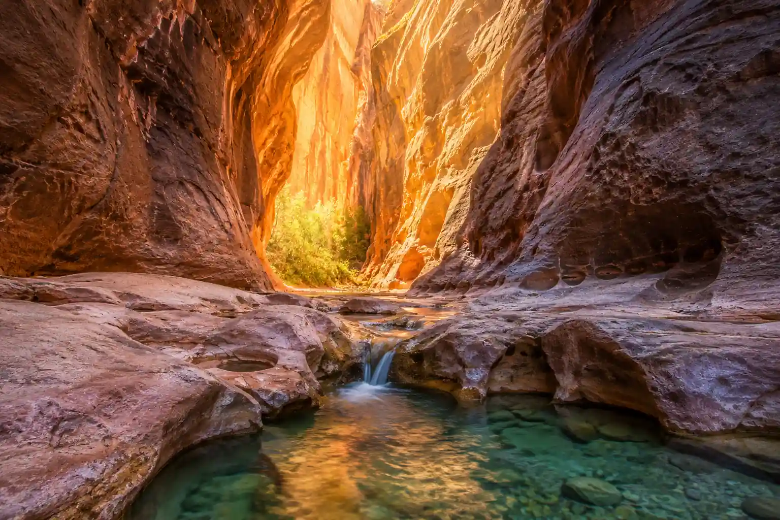
Page & Lake PowellSlot canyon wallsLower Antelope Canyon & Horseshoe Bend
Lower AntelopeColorado RiverStart with Lower Antelope Canyon, a narrower, more adventurous slot that you descend on steel ladders. It feels more intimate and is usually a bit less crowded than the Upper canyon, though it is still a guided Navajo tour.
In the afternoon, drive a few minutes to the Horseshoe Bend overlook for the classic view of the Colorado River wrapping a sandstone butte. It is a short, exposed 1.5-mile round-trip walk, so bring water and time it for softer morning or late-afternoon light.
- ~1.5 hr · ladders & tight passages · $50–$80+ pp
- 1.5 mi RT · ~150 ft · $10/vehicle parking
- Overnight in Page, AZSecond night before heading to the Paria region
- Lower Antelope Canyon involves several steep ladders and tight turns; skip it if you have mobility or claustrophobia concerns.
- Horseshoe Bend has no shade or railings at most of the rim, so keep back from the edge and carry water even for the short walk.
- If you have extra time, a paddle or short cruise on Lake Powell from Wahweap is an easy add-on from Page.
Paria Canyon-Vermilion Cliffs & Wire Pass
Drive west into the remote Paria Canyon-Vermilion Cliffs Wilderness and hike from the Wire Pass Trailhead down through a tight slot to the confluence with Buckskin Gulch, one of the longest and deepest slot canyons on earth. The out-and-back to the confluence is about 3.4 miles.
With a high-clearance 4x4 and experience (or a booked guide), you can instead spend the day at White Pocket and its swirled brain-rock sandstone. Either way, a Recreation.gov day-use permit is required for the Paria area, and House Rock Valley Road can be impassable when wet.
- Drive to House Rock Valley Road50–100 mi · dirt road · check BLM conditions
- 3.4 mi RT · slot canyon · day-use permit required
- Full day · high-clearance 4x4 or guided tour
- Overnight in Kanab, UTMore dining & lodging than Page · Wave-lottery base
- Buy your Paria / Buckskin Gulch day-use permit on Recreation.gov ahead of time and carry a printed copy.
- Download offline maps before you leave pavement. There is no cell service on House Rock Valley Road or in the wilderness.
- Never enter Buckskin Gulch or Wire Pass if rain is forecast anywhere in the watershed; a distant storm can send a flash flood through the slot.
White PocketHouse Rock RoadThe Wave Lottery or Deeper Buckskin Gulch
Kanab base townBuckskin backupIf you did not win the online lottery, try the daily walk-in lottery for The Wave (Coyote Buttes North) at the Kanab Visitor Center. Only 64 permits are issued each day and demand is high, so results are announced around 9 AM and you must be present to apply.
If you win, hike the challenging, unmarked 6.4-mile round trip to The Wave. If not, use your Paria day-use permit to go deeper into Buckskin Gulch for a longer, truly epic slot-canyon day. Always carry a headlamp and be ready to wade cold water in the gulch.
- Daily ~9 AM · 64 permits/day · must be present
- 6.4 mi RT · ~350 ft · unmarked desert navigation
- 6–15+ mi RT · deep slot · day-use permit
- Overnight in Kanab, UTFinal night before the Grand Canyon
- The Wave walk-in lottery success rate is very low, so treat Buckskin Gulch as your real plan and The Wave as a bonus.
- The Wave has no trail, shade, or water; download the Recreation.gov photo/GPS route guide and carry 3-4 liters per person.
- Kanab has more restaurants and lodging than Page and is the natural base for both the lottery and the Paria trailheads.
Drive to the Grand Canyon South Rim & Desert View
Drive south from Kanab to the Grand Canyon National Park South Rim, entering via the East (Desert View) Entrance so you can work the overlooks along Desert View Drive as you arrive.
Stop at the historic Desert View Watchtower, designed by Mary Colter, and continue to Lipan Point and Grandview Point for wide views of the Colorado River and the canyon's geologic layers. Check into your in-park lodge or nearby Tusayan for the night.
- Drive to Grand Canyon South Rim~150 mi · 3 hr · $35/vehicle 7-day entry
- Historic Mary Colter tower · East Entrance
- Lipan Point & Grandview PointWide Colorado River & Unkar Delta views
- El Tovar, Bright Angel, Maswik, or Mather Campground
- An America the Beautiful pass ($80/year) pays off fast if you are also visiting other national parks on this trip.
- Fill your tank before entering the park; in-park fuel is limited and expensive.
- Entering from the east lets you sightsee Desert View Drive on the way in instead of backtracking later.
Desert View WatchtowerLipan PointSouth Kaibab Trail into the Canyon
Cedar RidgeInner canyonTake the free shuttle to the South Kaibab Trailhead (no private cars) and hike down for the trip's best in-canyon views. Cedar Ridge is a great turnaround at 3 miles round trip and 1,120 ft of climbing on the way back out.
Strong hikers can push to Skeleton Point (6 miles round trip, ~2,040 ft) for the first look at the Colorado River. Remember the golden rule: going down is optional, coming up is mandatory, and there is no water or shade on South Kaibab.
- 3 mi RT · 1,120 ft · strenuous · shuttle only
- 6 mi RT · 2,040 ft · very strenuous
- Overnight at Grand Canyon South RimRecover for tomorrow's Bright Angel hike
- Start early to beat the heat; South Kaibab is fully exposed with no water sources anywhere on the trail.
- Turn around by the time you have drunk half your water, and never try to reach the river and back in a single day.
- Carry 2-3 liters per person minimum, plus salty snacks to replace what you sweat out on the climb back up.
Bright Angel Trail & the Rim Trail
Hike down the historic, well-graded Bright Angel Trail, which has more shade and seasonal water than South Kaibab. The 1.5-Mile Resthouse (3 miles round trip) or 3-Mile Resthouse (6 miles round trip, ~2,040 ft) make natural turnarounds.
Spend the afternoon on the flat, paved Rim Trail, linking Mather Point and the Yavapai Geology Museum with easy shuttle access between viewpoints. It is a relaxed counterpoint to the morning's climb.
- 3 mi RT · 1,130 ft · seasonal water
- 6 mi RT · 2,040 ft · strenuous
- Rim Trail: Mather Point & YavapaiPaved · accessible · shuttle stops
- Overnight at Grand Canyon South RimThird rim night
- Check the NPS website for current seasonal water status at the Bright Angel resthouses before you rely on it.
- Mule trains have the right of way; step to the inside wall and wait quietly as they pass.
- The Rim Trail is a great low-effort day if your legs are tired from South Kaibab, with sunset views from Yavapai Point.
Mather PointRim TrailHermit Road & a Grand Canyon Sunset
Hermit RoadSouth RimRide the free park shuttle along Hermit Road (closed to private cars most of the year), stopping at Maricopa Point, Hopi Point, and Pima Point. You can walk between some viewpoints for a quieter, ever-changing perspective on the canyon.
Save the evening for a Grand Canyon sunset from Hopi or Mather Point, where the light turns the buttes and side canyons deep orange and violet. Shuttles run frequently after dark, so you do not need to rush back.
- 7 mi · Maricopa, Hopi & Pima Points
- Sunset at Hopi PointPrime wide-canyon sunset · arrive early
- Overnight at Grand Canyon South RimFinal rim night
- Check the NPS site for the Hermit Road shuttle schedule and seasonal private-vehicle dates before you plan the day.
- Arrive at your sunset viewpoint 30-45 minutes early to claim a spot, especially at Hopi Point in peak season.
- Bring a layer for the evening; the rim cools off fast once the sun drops below the horizon.
Sedona Red Rocks & Scenic Byway
Drive south through Oak Creek Canyon on AZ-89A to Sedona and its world-famous red-rock country. Stretch your legs on an easy-to-moderate hike like the Bell Rock Pathway or Fay Canyon to a natural arch.
Cruise the Red Rock Scenic Byway (Highway 179) with its many pull-offs and galleries, then settle into Sedona for the evening. A Red Rock Pass is required to park at most trailheads.
- Drive to Sedona via Oak Creek Canyon~100 mi · 2 hr · AZ-89A scenic route
- 2–3 mi RT · red-rock views · Red Rock Pass
- Red Rock Scenic Byway (Hwy 179)~15 mi · overlooks & galleries
- Overnight in Sedona, AZHotels, resorts & B&Bs
- Buy a Red Rock Pass ($5/day) for trailhead parking, or use your America the Beautiful pass where accepted.
- Sedona traffic backs up badly on weekends; hike early and save town browsing for the afternoon.
- The AZ-89A drive down Oak Creek Canyon is a highlight in itself, so allow time for the pull-offs.
Bell RockOak Creek CanyonDepart from Phoenix
Verde ValleyPhoenix / PHXEnjoy a last Sedona morning, maybe a short hike or some gallery browsing, then drive south to Phoenix Sky Harbor International Airport (PHX) for your flight home, about two hours away.
Allow extra buffer for traffic near the airport and factor in time to return your rental car. A breakfast stop in the Verde Valley is an easy way to break up the drive.
- Drive to Phoenix Sky Harbor (PHX)~120 mi · 2 hr from Sedona
- Final Sedona morningShort hike or souvenir shopping before you leave
- Leave Sedona with plenty of margin; the final stretch into Phoenix can be slow near rush hour.
- Fill your rental's tank near the airport to avoid steep refueling charges from the rental company.
- A breakfast stop in the Verde Valley (Cottonwood or Camp Verde) makes a relaxed end to the drive.
Now build your Arizona trip.
You've seen all ten days. Open the free drag-and-drop planner and tune it for your dates, your fitness, and whether you win a slot-canyon permit or need a backup plan.
Essential permits & desert safety for this trip.
Flash floods are the real danger
Slot canyons like Buckskin Gulch, Wire Pass, and Antelope are extremely dangerous in rain, even from a storm miles away. Check the forecast for the entire watershed and postpone if there is any chance of rain. Monsoon season (July-September) has the highest risk.
Every canyon needs a permit
Antelope Canyon is guided-tour only on Navajo Nation land (book 3-6 months ahead). Paria Canyon / Buckskin Gulch need Recreation.gov day-use permits. The Wave (Coyote Buttes North) is a competitive lottery, four months out online or a daily walk-in in Kanab. The Grand Canyon charges a $35/vehicle entrance fee.
Go in spring or fall
March-May and September-October bring mild temperatures and fewer crowds. Summer regularly tops 100°F in the canyons with real heatstroke and flash-flood risk, and winter can bring snow and ice to the Grand Canyon and cold standing water in the slots.
You need the right vehicle
A standard 2WD car handles most of this route, but remote spots like White Pocket in the Vermilion Cliffs absolutely require a high-clearance 4x4 and experience on unmaintained dirt roads. Book a guided tour for those areas if you are not equipped.
Carry more water than you think
Bring at least 3-4 liters per person per day and more for the Grand Canyon corridor hikes and The Wave, where there is no water, shade, or reliable cell service. Turn around when you have used half your water.
Respect tribal land & Leave No Trace
Much of the Page area is Navajo Nation land; follow tour and access rules. Pack out everything, stay on designated routes, and do not touch or climb on the fragile sandstone formations at The Wave and White Pocket.
Everything you'll actually want to know.
Ready to go? Get your
Arizona canyoneering route.
The permits and lottery timing, guided-tour bookings, drive times between Page, Kanab, the Grand Canyon and Sedona, the flash-flood and desert-heat rules, and a slot-canyon backup plan for the days the lottery does not go your way.
Instant book · Free cancellation · Secure payment via Stripe


Planning this trip?
Save it, share it with your crew, or find travelers heading the same way.

Liked this itinerary?
What other travelers are saying
Be the first to leave a tip or question for the next traveler.