Sea Caves to Door County:
10 Days in the Northwoods
Ten days through northern Wisconsin: Apostle Islands sea caves by kayak, Copper Falls, the Chequamegon-Nicolet forest, the Minocqua and Eagle River lakes, Devils Lake bluffs, and Door County.
Free interactive planner · drag & reorder your days, add stops, map it in minutes
Build your own Northwoods trip, drag, reorder & map it.
Drag stops between days, swap a paddle for a waterfall hike, and add your own lakes and overlooks with the place search. The live map and drive times recalculate as you go, so you can balance the long Lake Superior leg against the easy Northwoods days.
Opens a side panel · reorder days, add custom stops, see your route live
One loop, sea caves, waterfalls & Northwoods lakes, across northern Wisconsin.
Northern Wisconsin is a different state from the dairy farms most people picture: a sweep of glacial lakes, deep pine and hardwood forest, Lake Superior sea caves, and waterfalls tumbling over ancient rock. This Wisconsin Northwoods road trip strings the best of it into a 10-day loop, from the Apostle Islands on Lake Superior down through the lake country around Minocqua and Eagle River to the quartzite bluffs of Devils Lake, then east to Door County.
You'll mix sea-cave kayaking at the Apostle Islands National Lakeshore, waterfall hikes at Copper Falls State Park, the trails and lakes of the Chequamegon-Nicolet National Forest, quiet paddling and supper-club dinners in the Northwoods lakes, bluff hikes high above Devils Lake, and the lighthouses and cherry orchards of Door County. It is a loop built for slow summer days and blazing fall color.
Summer (June through August) brings warm lakes and the best paddling, though early summer can be buggy, so pack repellent. Fall color peaks late September into early October and is spectacular across the Northwoods. Winters are long and snowy, beautiful but cold, and in rare deep-freeze years the famous Apostle Islands ice caves become walkable, though that is never guaranteed.
Bayfield is small and fills fast in summer and fall-color season, so book lodging early. The Apostle Islands sea-cave kayak depends on Lake Superior conditions, which can cancel a trip on short notice, so reserve a flexible date and leave a weather buffer. Devils Lake is the most-visited state park in Wisconsin and its lots fill on summer weekends, so arrive early or go midweek.


Drive to Bayfield · Lake Superior gateway
Start in Bayfield, the small Lake Superior harbor town that is the gateway to the Apostle Islands. It is about an hour and a half from Duluth (DLH) or roughly four hours from Madison (MSN), with the last stretch running along the big lake. Settle in, walk the docks, and get your bearings on the water you'll be paddling tomorrow.
Spend the afternoon easing into Northwoods time: browse the orchards and shops, watch the ferries come and go, and have your first dinner of fresh Lake Superior whitefish. Bayfield is tiny and books up in summer and fall, so this is your base for the next two nights while you explore the Apostle Islands National Lakeshore.
- Drive to BayfieldDuluth (DLH) ~1.5 hr · Madison (MSN) ~4 hr · last stretch along Lake Superior
- Lake Superior gateway town · ferries, orchards & whitefish
- Stay in BayfieldSmall town, books fast in summer & fall · two nights here
- Bayfield is small and fills fast on summer and fall-color weekends. Reserve lodging well ahead and base here for two nights.
- The closest airport is Duluth (DLH), about 90 minutes away. Central Wisconsin (CWA) and Madison (MSN) are farther but useful if you fly the loop in reverse.
- Try the fresh Lake Superior whitefish in town your first night. It sets the tone for a slow Northwoods trip.


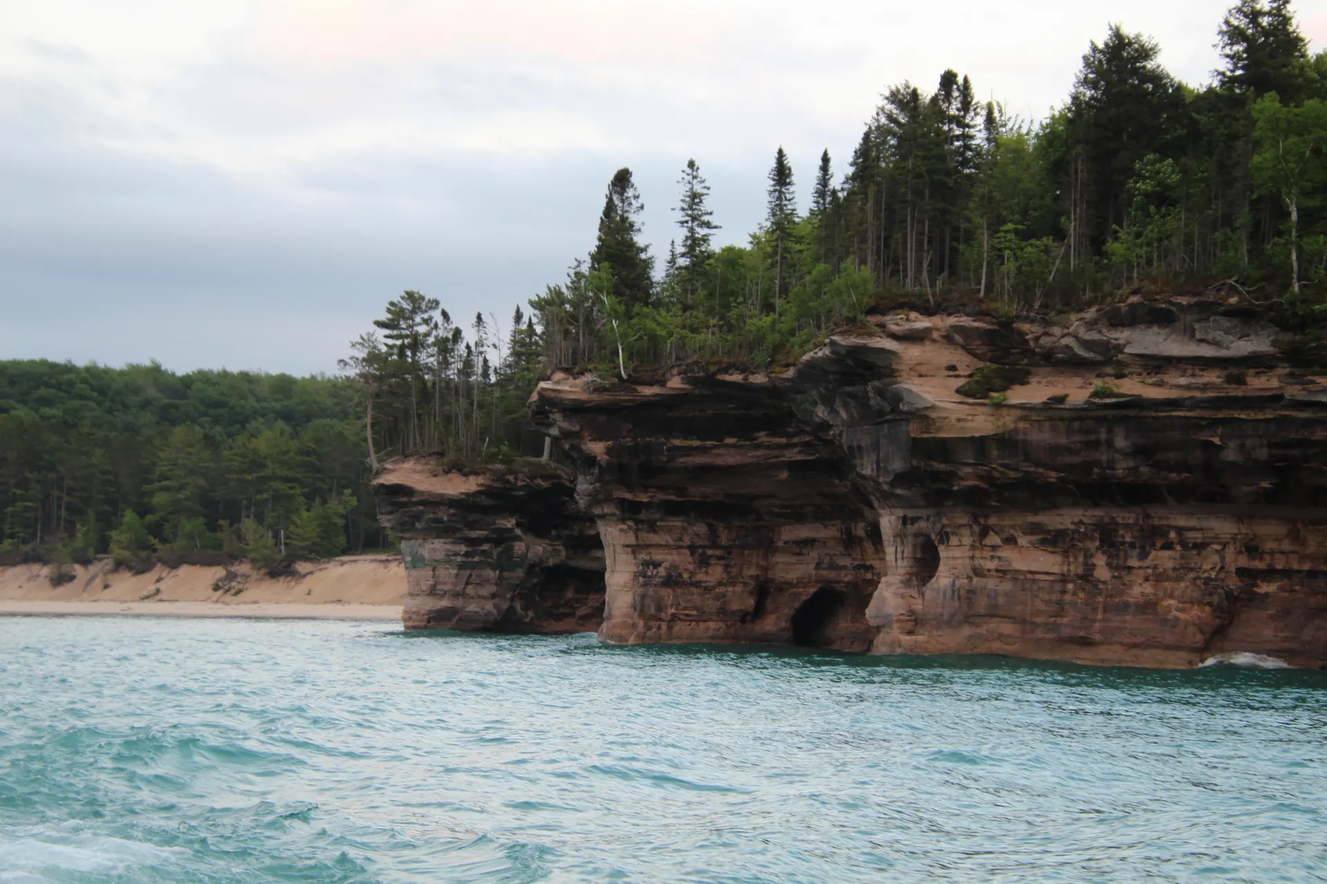
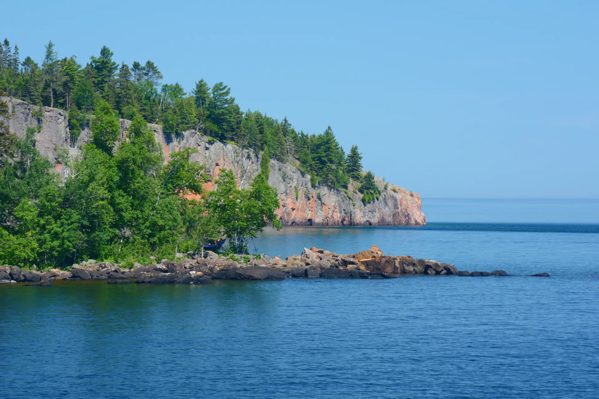
Apostle Islands sea caves by kayak

This is the headline day. Paddle the Apostle Islands sea caves, where Lake Superior has carved arches, chambers, and honeycombed sandstone cliffs along the Mainland and Devils Island shorelines. The best way in is by kayak on a calm-water morning, threading the boat between cathedral-like walls you simply cannot reach on foot.
Book a guided sea-cave kayak tour with Lost Creek Adventures, the established Apostle Islands outfitter, which handles the boats, the safety, and the all-important weather call. Lake Superior is cold, big, and moody, so a guided trip is the smart way to see the caves, and trips can cancel on short notice when the wind picks up, so keep your schedule flexible.
- Sandstone arches & chambers · paddle in on calm water
- Second night in BayfieldStay put for an easy launch and a weather buffer
- Lost Creek Adventures is the established Apostle Islands kayak outfitter. Book a guided sea-cave tour ahead and keep your dates flexible in case wind cancels.
- Lake Superior is genuinely cold and conditions change fast. A guided trip handles the boats, gear, and the weather call so you can just paddle.
- In rare deep-freeze winters the same shoreline becomes the famous Apostle Islands ice caves, walkable over the frozen lake, but that only happens some years and is never guaranteed.
Madeline Island ferry & the Bayfield Peninsula
Take the short ferry from Bayfield across to Madeline Island, the only one of the Apostle Islands with a town and the easiest to reach. Rent a bike or drive the quiet roads to Big Bay State Park, walk the beach and the bog boardwalk, and slow down on the largest island in the chain before the ferry back.
Back on the mainland, drive the orchard-lined roads of the Bayfield Peninsula for views over the islands, and consider a stop at the Mainland sea caves overlook or one of the apple and berry farms. This is your last Lake Superior day before the route turns south into the forest and lake country.
- Short ferry from Bayfield · the one island with a town
- Beach, bog boardwalk & sandstone · bike or drive the island
- Bayfield Peninsula orchards & overlooksApple and berry farms · island views from the headlands
- Last night in BayfieldPack up tonight for the drive south tomorrow
- The Madeline Island ferry runs frequently in summer from the Bayfield dock. Check the last return time so you do not get stranded on the island.
- Big Bay State Park on Madeline Island has a Wisconsin state park sticker requirement. Bring your annual sticker or buy a day pass.
- The Bayfield Peninsula is orchard country. Late summer brings apples and berries at the farms along the headland roads.
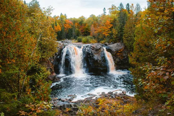
Copper Falls State Park · waterfalls & gorge

Turn south into the forest and stop at Copper Falls State Park near Mellen, one of the most scenic spots in northern Wisconsin. The Doughnuts Falls Trail loop follows the Bad and Tyler Forks rivers past Copper Falls, Brownstone Falls, and a deep wooded gorge, with log railings and stone overlooks built into the cliffs.
It is an easy-to-moderate few miles, and the tannin-stained water dropping through black volcanic rock is unlike anywhere else on the trip. Picnic at the park, then carry on toward the heart of the Chequamegon-Nicolet National Forest and the Northwoods lake country for the next leg of the loop.
- Doughnuts Falls Trail · ~2.5 mi · easy to moderate · gorge overlooks
- Bad River gorge overlooksTannin-stained water through black volcanic rock · stone railings
- Drive on toward the Northwoods lakesThrough the Chequamegon-Nicolet forest toward Minocqua
- The Doughnuts Falls Trail loop is the classic Copper Falls walk, passing Copper Falls, Brownstone Falls, and the gorge overlooks in a couple of easy miles.
- Copper Falls is a Wisconsin state park, so you need a vehicle sticker. A $28 annual sticker pays off fast on this loop, which hits several state parks.
- The water runs dark with tannins from the north-woods bogs. After heavy rain the falls are loudest, but trails can be slick on the rock.
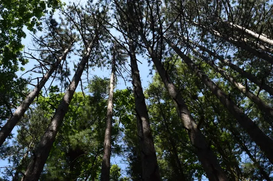
Chequamegon-Nicolet forest · trails, lakes & fall color
Spend a day in the Chequamegon-Nicolet National Forest, a million-plus acres of pine, hardwood, and glacial lakes that form the green heart of the Northwoods. A stretch of the North Country National Scenic Trail runs through the forest, and there are quiet lakes, old-growth groves, and forest roads in every direction.
In late September and early October this is one of the best places in the Midwest for fall color, with maples and birches turning the whole forest gold and red. Hike a section of the North Country Trail, paddle a quiet lake, and then drive on to your Northwoods base around Minocqua for the next leg.
- A stretch of the national scenic trail through the forest
- Quiet glacial lakes · canoe, kayak or SUP
- Fall color drivesLate Sep–early Oct · maples & birches across the Northwoods
- Move to a Minocqua baseSettle into the lake country for the next few nights
- A long section of the North Country National Scenic Trail runs through the Chequamegon-Nicolet forest. Pick a day-hike segment from a forest trailhead.
- Fall color usually peaks in the last week of September and the first week of October up here, earlier than the southern part of the state.
- The national forest has free, undeveloped lakes everywhere. Bring or rent a canoe and find a quiet one for an hour of paddling.
Minocqua & Eagle River · paddling, fishing & supper clubs
Settle into the classic Northwoods lakes around Minocqua and Eagle River, where chains of clear glacial lakes link together for some of the best paddling and fishing in the Midwest. Eagle River sits on a 28-lake chain, one of the longest interconnected freshwater chains in the world, so you can paddle or boat for hours without taking out.
Spend the day on the water: rent a canoe, kayak, or pontoon, fish for walleye and muskie, and swim off a sandy bay. Then do the most Wisconsin thing there is and book a table at a supper club for a brandy old-fashioned, a relish tray, and a slow lakeside dinner as the loons call.
- Paddle the lake chainsMinocqua & the Eagle River 28-lake chain · canoe, kayak or pontoon
- Fishing on the Northwoods lakesWalleye, muskie & panfish · the heart of Wisconsin fishing country
- Supper club dinnerBrandy old-fashioned, relish tray & a lakeside table · the Northwoods classic
- Stay around MinocquaLake-country base for two nights
- The Eagle River Chain of Lakes is one of the longest interconnected freshwater chains in the world. You can paddle or boat between dozens of lakes without ever taking out.
- A supper club dinner is essential Northwoods culture: order a brandy old-fashioned, work through the relish tray, and plan for a slow, friendly evening.
- Early summer can be buggy on the lakes. Pack repellent and plan paddling for breezier midday hours when the mosquitoes ease off.
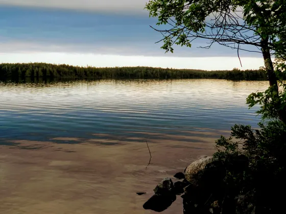
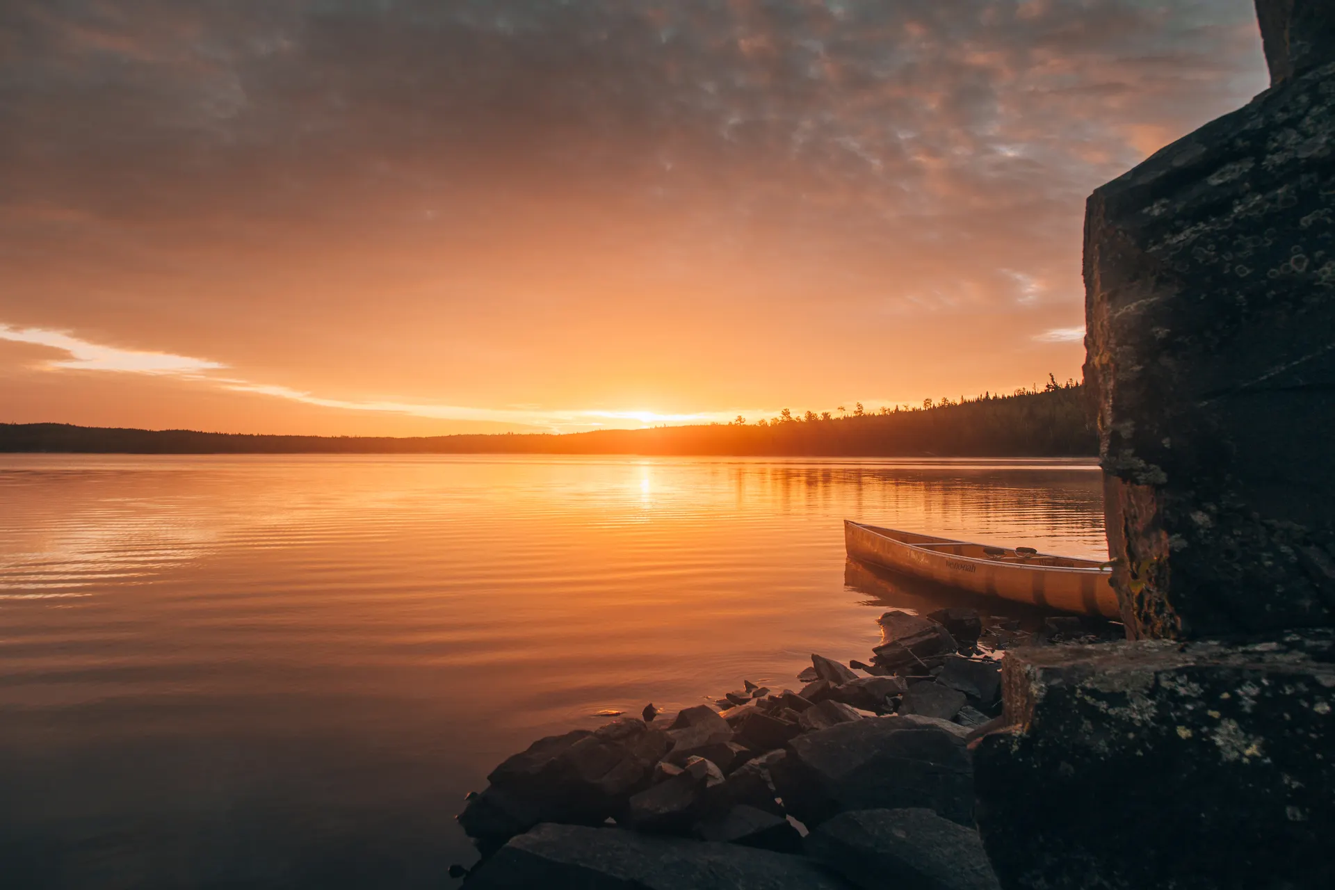
Turtle-Flambeau Flowage · wild water & loons
Drive out to the Turtle-Flambeau Flowage, a wild, island-studded 13,000-acre flowage northwest of Minocqua that feels far more remote than it is. It is a protected, largely undeveloped wilderness of bays, islands, and quiet channels, prime habitat for loons, eagles, and ospreys, and a paradise for paddlers and anglers.
Spend the day exploring by canoe or kayak, weaving between wooded islands and watching for wildlife, or fishing the bays for walleye and muskie. It is the wildest water on the loop, and a fitting last full day in the deep Northwoods before the route turns south toward Devils Lake tomorrow.
- Paddle the Turtle-Flambeau Flowage~13,000 acres · islands, bays & channels · canoe or kayak
- Loon, eagle & osprey watchingProtected wilderness flowage · prime northern wildlife habitat
- Fish the flowage baysWalleye, muskie & smallmouth · quiet, undeveloped water
- Last night around MinocquaPack up tonight for the drive south
- The Turtle-Flambeau Flowage is largely undeveloped wilderness. Bring a map or GPS, since the maze of islands and bays can be disorienting by canoe.
- It is excellent loon and eagle country. Go out early or late for the calmest water and the best wildlife sightings.
- There are scattered boat-in campsites on the flowage if you want to extend a day on the water into an overnight paddle trip.

South to Devils Lake · quartzite bluffs over clear water

Drive south to Devils Lake State Park near Baraboo, the most-visited state park in Wisconsin and a complete change of scenery: 500-foot quartzite bluffs rising straight out of a deep, clear lake. Base in Baraboo, just minutes away and a short hop from the Wisconsin Dells.
Hit the classic bluff hikes: the East Bluff Trail and the Balanced Rock and Devils Doorway routes climb through purple quartzite talus to overlooks straight down to the water far below. The trails are short but steep and rocky, so wear real shoes, then cool off with a swim from one of the park's sandy beaches.
- Quartzite bluff loops · steep & rocky · overlooks 500 ft over the lake
- Short, very steep climb past balanced quartzite boulders
- Swim at Devils LakeClear water & sandy beaches at the foot of the bluffs
- Stay in BarabooMinutes from the park · near Wisconsin Dells · two nights
- Devils Lake is the most-visited park in Wisconsin and its lots fill by mid-morning on summer weekends. Arrive early or visit midweek.
- The bluff trails are short but genuinely steep and rocky over quartzite talus. Wear hiking shoes, not sandals, and take the climbs slowly.
- Baraboo sits minutes from the park and a short drive from the Wisconsin Dells if you want a half-day add-on for the family.
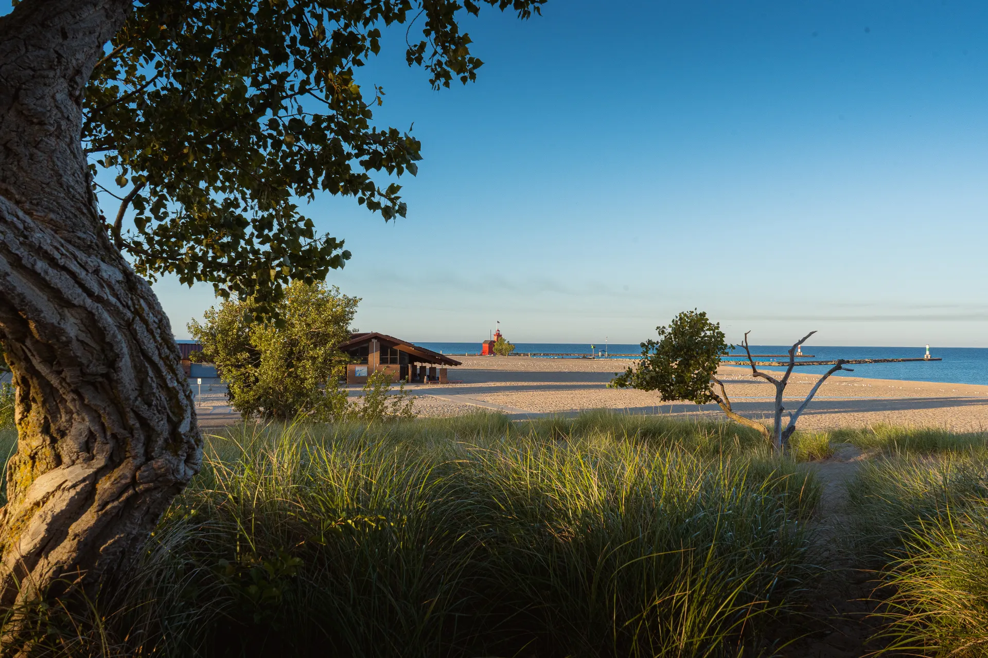
East to Door County · lighthouses & cherries
Drive east to Door County, the peninsula reaching out between Green Bay and Lake Michigan that is Wisconsin's favorite shoreline escape. It is a long but scenic transfer, so settle in for the afternoon among the harbor villages, cherry orchards, and white-clapboard lighthouses that line the coast.
Visit Peninsula State Park, one of the busiest in the state, for shoreline trails, the Eagle Bluff Lighthouse, and an overlook tower above the bay. Door County is famous for its cherries, so stop at an orchard stand, and cap the day with a traditional fish boil, the peninsula's signature lakeside dinner.
- Drive to Door CountyLong scenic transfer east to the peninsula
- Shoreline trails, an overlook tower & a historic lighthouse
- Cherry orchards & harbor villagesDoor County cherries · roadside stands & white lighthouses
- Stay in Door CountyHarbor-village base for the night
- It is a long drive from Devils Lake to Door County, so leave in the morning to have the afternoon on the peninsula.
- Peninsula State Park is one of the busiest in Wisconsin and needs a state park sticker. The Eagle Bluff Lighthouse and the Eagle Tower overlook are the highlights.
- A traditional Door County fish boil, with whitefish cooked over an open fire and a dramatic boil-over finale, is the classic peninsula dinner. Reserve ahead.

Door County shoreline & the drive home

Use your last morning on the Door County shoreline: walk a beach, drive up to the quiet northern tip for the Northport ferry view, or take in one more lighthouse before the route ends. It is an easy, unhurried close to the loop after ten days on the water and in the woods.
Getting home: from Door County it is roughly an hour to Green Bay (GRB), about two and a half hours to Milwaukee (MKE), or you can loop back toward Central Wisconsin (CWA) or Madison (MSN) depending on where you started. Top off your gas, and start the drive out with the Northwoods loop behind you.
- A beach walk, the northern tip, or one more lighthouse
- Getting home: Green Bay, Milwaukee or MadisonGRB ~1 hr · MKE ~2.5 hr · CWA / MSN if looping back
- Green Bay (GRB) is the closest airport to Door County, about an hour away. Milwaukee (MKE) is around two and a half hours and has more flights.
- If you flew into Duluth, Central Wisconsin, or Madison, plan the final leg back to your start airport, as Door County sits at the far east end of the loop.
- Leave time for one last shoreline stop. The northern tip of the peninsula is the quietest and most scenic corner of Door County.
Now build your Northwoods trip.
You've seen all ten days. Open the free drag-and-drop planner and tune it for your dates, your pace, and whether you base in Bayfield, Minocqua, or Baraboo for Devils Lake.
What we actually learned in the Northwoods.
Buy the Wisconsin state park sticker
This loop hits Copper Falls, Devils Lake, Peninsula, and Big Bay state parks, all of which require a vehicle sticker. A day pass runs about $13, but the $28 annual Wisconsin resident sticker (more for out-of-state) pays for itself quickly across the trip.
Treat the Apostle Islands kayak as weather dependent
Lake Superior is cold, big, and changeable. Sea-cave kayak trips can cancel on short notice when the wind comes up, so book a guided trip with an outfitter like Lost Creek Adventures, pick a flexible date, and build a weather buffer into your Bayfield nights.
Go in summer or fall
June through August brings warm lakes and the best paddling, though early summer can be buggy. Fall color peaks late September into early October and is spectacular across the Northwoods. Winters are long, deep, and snowy, beautiful but cold, and the famous ice caves only form in rare hard-freeze years.
Pack for bugs in early summer
Mosquitoes and black flies can be fierce in the Northwoods from late spring into early summer, especially near water at dawn and dusk. Bring repellent, consider a head net for buggy stretches, and plan paddling for breezier midday hours.
Plan the long transfer days
This is a big loop, roughly 850 miles. The Bayfield-to-Devils Lake and Devils Lake-to-Door County legs are the longest. Start those mornings early, fuel up in the small towns, and treat the drive itself as part of the scenery through the forest and lake country.
Book Bayfield and Devils Lake early
Bayfield is tiny and fills fast in summer and fall, and Baraboo near Devils Lake gets busy as the gateway to Wisconsin's most-visited park and the nearby Dells. Reserve those nights well ahead, and Minocqua and Door County lodging too for peak weekends.
Everything you'll actually want to know.
Ready to go? Get your
Wisconsin Northwoods route.
Drive times around the loop, the Apostle Islands kayak outfitter, state park stickers, the best Northwoods lakes and supper clubs, Devils Lake timing, and Door County logistics you need to plan northern Wisconsin.
Instant book · Free cancellation · Secure payment via Stripe
Planning this trip?
Save it, share it with your crew, or find travelers heading the same way.

Liked this itinerary?
What other travelers are saying
Be the first to leave a tip or question for the next traveler.