Smith Rock State Park:
A Weekend Hiking & Climbing Itinerary
Two days of Smith Rock hiking: the must-do Misery Ridge Loop up and over the ridge past Monkey Face, the flat River Trail along the Crooked River, and a taste of the birthplace of American sport climbing.
Free interactive planner · drag & reorder your days, add stops, map it in minutes
Build your own Smith Rock weekend, drag, reorder & map it.
Drag stops between days, swap the steep Misery Ridge climb for the flat River Trail, and add your own overlooks and trailheads with the place search. The live map and drive times recalculate as you go, and we'll warn you before you build a brutal high-desert afternoon.
Opens a side panel · reorder days, add custom stops, see your route live
One park, sheer spires, a desert river & world-class rock, in central Oregon.
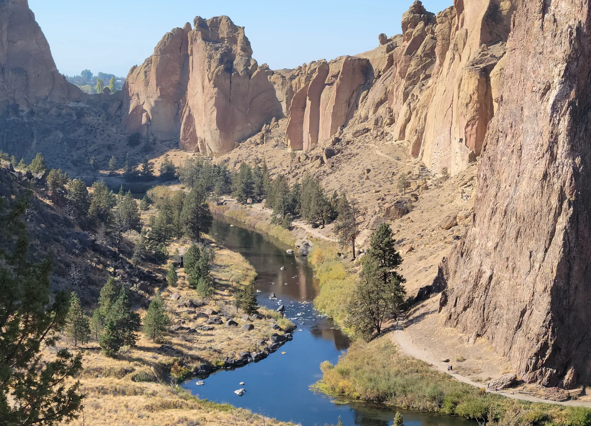
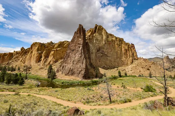
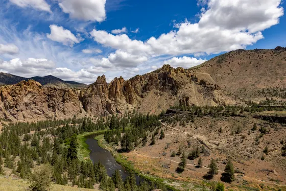
Smith Rock State Park sits in the high desert of central Oregon near Terrebonne, where sheer walls of welded volcanic tuff rise hundreds of feet above a bend in the Crooked River. It is widely considered the birthplace of American sport climbing, and on any given weekend you'll see climbers stitched up the rust-colored cliffs while hikers wind along the river below.
This weekend route is built around Smith Rock hiking: the must-do Misery Ridge Loop climbs steeply up and over the ridge for huge views past the iconic Monkey Face spire, then drops back along the flat River Trail beside the Crooked River. You'll mix that signature loop with easy riverside walking, the chance to watch (or try) the climbing, and the wide-open high-desert light at sunrise and sunset.
Spring and fall are the prime seasons, with comfortable days and cooler air. Summer afternoons get hot in this exposed canyon, so start hikes early and carry plenty of water. This is desert country, so watch for rattlesnakes and ticks, and note that golden eagles nest on some of the walls, which closes a few climbing routes seasonally.
Smith Rock is a day-use state park with a $5 day-use parking fee and no in-park lodging beyond a walk-in, tent-only bivouac campground. Base in nearby Terrebonne, Redmond, or Bend and drive in, and book lodging ahead for summer and fall weekends when central Oregon fills up. Redmond Airport (RDM) is only about 20 minutes away.

Misery Ridge Loop · up and over past Monkey Face
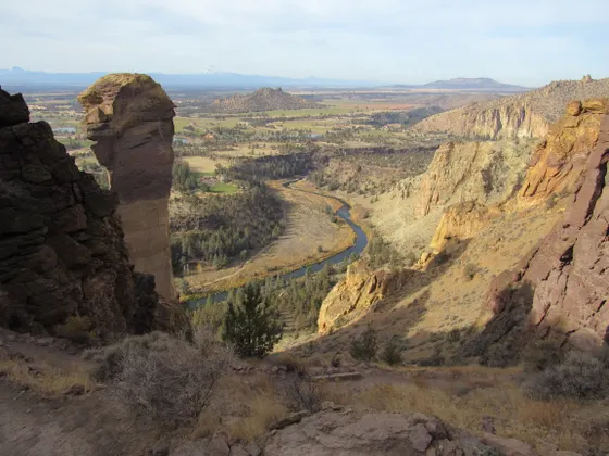
Start your weekend with the park's signature route, the Misery Ridge Loop (about 3.7 to 4 miles round trip). Drop from the parking area down to the footbridge over the Crooked River, then climb the steep, switchbacking Misery Ridge Trail straight up the face of the rock. It earns its name, but the payoff is enormous: sweeping high-desert views and a head-on look at the Monkey Face, the 350-foot freestanding spire that is one of the most famous formations in American climbing.
From the ridge, the trail descends the back side toward Monkey Face and joins the flat River Trail, which loops you back along the Crooked River beneath the climbing walls to the bridge. Because the canyon is exposed and hot in the afternoon, start early, carry plenty of water, and take the steep section slowly. Watch your footing on the loose tuff, and keep an eye out for rattlesnakes sunning on the rocks.
- ~3.7–4 mi loop · steep · the must-do · Monkey Face views
- Monkey Face viewpoint350-ft freestanding spire · iconic from the ridge
- Crooked River footbridgeCross to start the loop · flat River Trail follows the water
- Pay the $5 day-use feeDay-use state park · pay at the lot · no entry without it
- Misery Ridge is steep and fully exposed. Start at first light in summer, carry at least 2 liters of water per person, and take the switchbacks slowly.
- Smith Rock is a day-use state park with a $5 day-use parking fee. Pay at the lot, and arrive early on weekends because the main lots fill up.
- This is high desert, so watch for rattlesnakes on warm rocks and check for ticks after you hike. Keep dogs leashed on the trails.

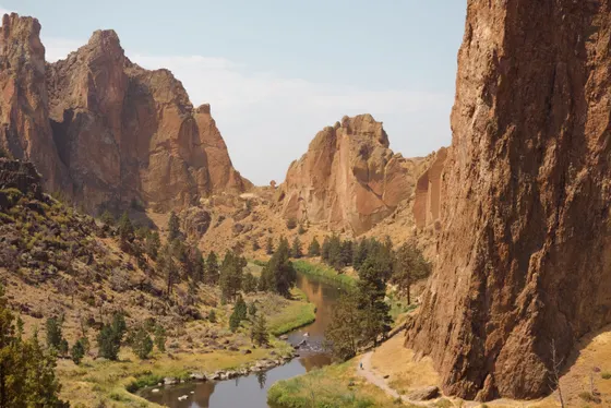
River Trail, climbing & high-desert light

Take it easier on day two with the flat River Trail, which follows the Crooked River along the base of the cliffs with almost no elevation gain. It is the best place to crane your neck up at the walls, watch climbers work the routes, and feel the scale of the park without the burn of Misery Ridge. From here you can branch onto the Wolf Tree, Burma Road, or Summit Trail if you want more distance or a different angle on the rock.
Smith Rock is the birthplace of American sport climbing, with more than 1,800 routes from beginner slabs to the legendary lines on Monkey Face, so spend part of the day watching the action or arrange a half-day with a local guide if you want to tie in. Save the last hour for the high-desert light: the rust-colored tuff glows at sunset, and the wide-open sky over the Crooked River is the kind of view that makes the weekend. Getting home: Redmond Airport (RDM) is only about 20 minutes away, and Bend is roughly 30 minutes south.
- Flat · easy · best views of the walls and climbers
- Add distance or a new angle · varied effort
- Watch the climbing1,800+ routes · the birthplace of American sport climbing
- Sunset over the spiresRust-colored tuff glows · wide high-desert sky
- The River Trail is flat and follows the Crooked River, so it is the gentle counterpart to Misery Ridge and the best spot to watch climbers on the walls.
- Golden eagles nest on some of the cliffs, which closes a handful of climbing routes seasonally. Respect any posted closures if you climb.
- Redmond Airport (RDM) is about 20 minutes away and Bend is around 30 minutes south, so it is an easy weekend to fly in and out of.
Now build your Smith Rock weekend.
You've seen both days. Open the free drag-and-drop planner and tune it for your dates, your pace, and whether you base in Terrebonne, Redmond, or Bend.
What we actually learned in the high desert.
Pay the $5 day-use fee
Smith Rock is a day-use state park with a $5 per-vehicle day-use parking fee. Pay at the parking area when you arrive, or use an Oregon State Parks annual pass. There is no overnight parking at the main lots.
Lodging is outside the park
The only camping is a walk-in, tent-only bivouac campground near the rim. For everything else, base in Terrebonne right next door, in Redmond about 10 minutes away, or in Bend about 30 minutes south, and book ahead for summer and fall weekends.
Hike early and beat the heat
The canyon is exposed and bakes in summer afternoons. Spring and fall are the best seasons, but in summer start Misery Ridge at first light, carry plenty of water, and save the flat River Trail for the warmer part of the day.
Carry your own water
There is no water out on the trails, and the high desert is dry. Bring at least 2 liters per person for Misery Ridge, more in summer, and pack out everything you bring in.
Watch for snakes and ticks
This is rattlesnake country, so watch where you step and reach, especially on warm rocks. Check yourself for ticks after hiking, and keep dogs leashed on the trails to protect them and the wildlife.
Respect the climbing and closures
Smith Rock is the birthplace of American sport climbing with over 1,800 routes. Golden eagles nest on some walls and close certain routes seasonally, so check and respect posted closures whether you climb or just watch.
Everything you'll actually want to know.
Ready to go? Get your
Smith Rock weekend route.
Trailheads and mileages, the Misery Ridge Loop, the flat River Trail, the $5 day-use fee, where to stay near Redmond and Bend, and the early-start timing you need to hike Smith Rock comfortably.
Instant book · Free cancellation · Secure payment via Stripe

Planning this trip?
Save it, share it with your crew, or find travelers heading the same way.

Liked this itinerary?
What other travelers are saying
Be the first to leave a tip or question for the next traveler.