Pennsylvania Grand Canyon Map +
5-Day West Rim Trail Itinerary
5-day Pennsylvania Grand Canyon backpacking itinerary. Hike the 30-mile West Rim Trail high above Pine Creek Gorge, drop to the gorge floor for a Pine Creek paddle on the rail trail, and climb back to the rim, all from a Wellsboro base in Tioga State Forest.
Free interactive planner · drag & reorder your days, add stops, map it in minutes
Build your own PA Grand Canyon trip, drag, reorder & map it.
Drag stops between days, swap overlooks, and add your own trailheads and gorge access points with the place search. The live map and trail legs recalculate as you go, so you can tune the West Rim Trail route to your pace before you head into Tioga State Forest.
Opens a side panel · reorder days, add custom stops, see your route live
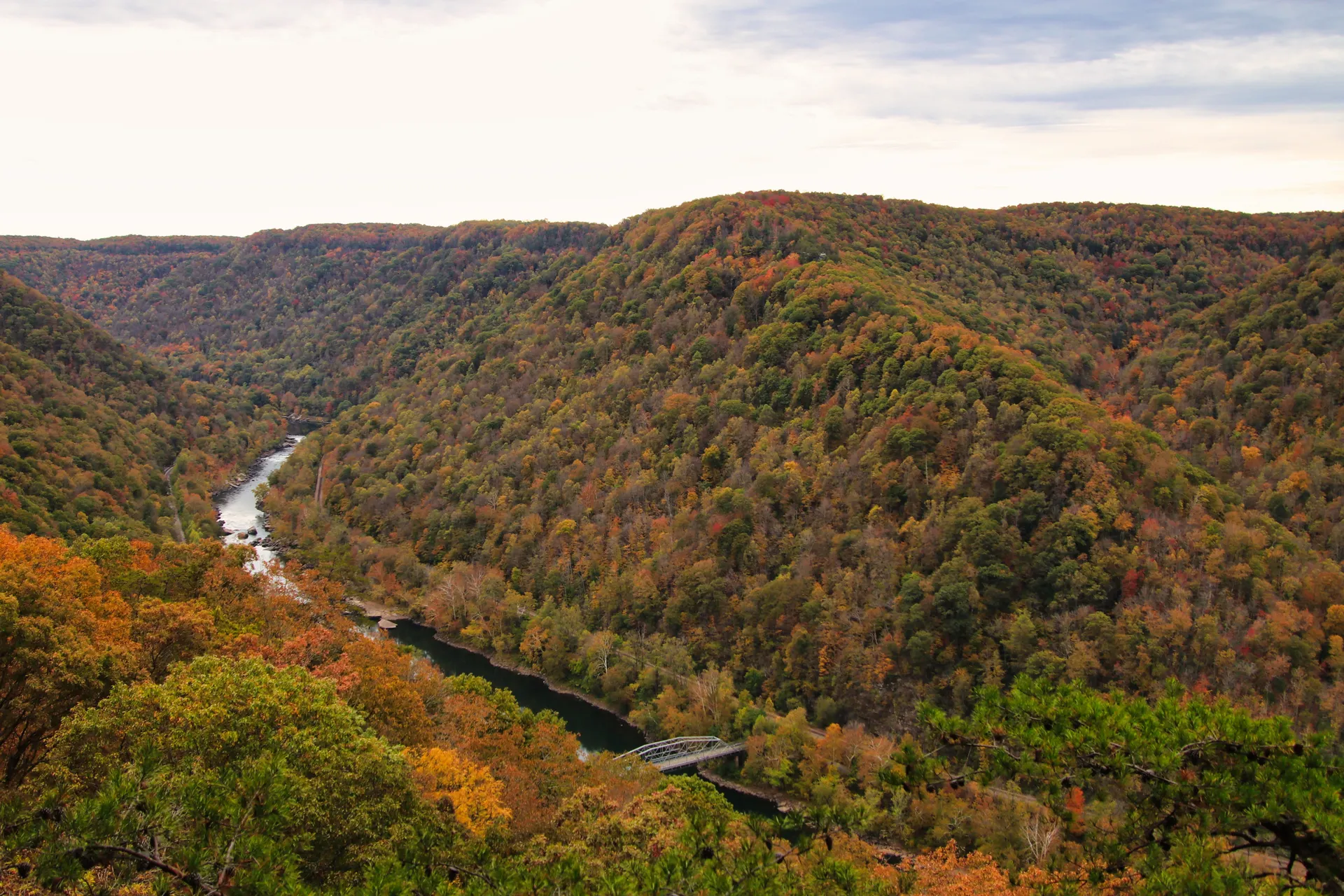
The West Rim Trail & Pine Creek Gorge, Pennsylvania's Grand Canyon.
For a 5-day backpacking trip in Pennsylvania's Grand Canyon, base your logistics out of Wellsboro and the northern West Rim Trail trailhead near Ansonia. The West Rim Trail runs about 30 miles along the western rim of Pine Creek Gorge in Tioga State Forest, with near-continuous views 800 feet down to Pine Creek.
This itinerary hikes south along the rim past classic overlooks like Barbour Rock and Bradley Wales, drops a side trail to the gorge floor for a section of the flat Pine Creek Rail Trail and an optional Pine Creek paddle, then climbs back to the rim and out, roughly 40 miles over five days with 4,000+ ft of cumulative elevation change.
There are no trail or entry fees. A free primitive-camping permit from the DCNR Tioga district office is required to camp more than one night at the same site (and for spring campfires or an emergency point of contact). May through October is the season; late September into October brings the best foliage and weather of the year.
The West Rim Trail is point-to-point, so most backpackers arrange a car spot or shuttle through Pine Creek Outfitters in Ansonia (pinecrk.com); book kayak or canoe rentals and shuttles ahead, especially on fall weekends. Camping is first-come, first-served with no reservations, but pick up a free primitive-camping permit from the DCNR Tioga district office (570-724-2868) if you'll camp more than one night at a site. Wellsboro is the base town for lodging, gear, and a celebratory meal.
Ansonia Trailhead & West Rim Trail North · 8 miles
Drive to Ansonia and the northern West Rim Trail trailhead, a forestry parking lot on Colton Road just south of US 6. Fill out a free primitive-camping self-registration if you'll be at one site more than a night, then start south along the rim as the gorge opens up beside you.
Hike roughly 8 miles past the first overlooks and make camp at a designated primitive site off the West Rim Trail. Camp 200 feet from water, trails, and roads, store food in a bear bag or canister, and filter all your water, black bears are active throughout Tioga State Forest.
- Colton Road off US 6 · parking + self-registration kiosk
- ~8 mi south along the rim · scenic overlooks
- Required for multi-night stays · call 570-724-2868
- The West Rim Trail is point-to-point between Ansonia and Blackwell, so arrange a car spot or a shuttle through Pine Creek Outfitters if you plan to thru-hike rather than loop back.
- Pick up a free primitive-camping permit from the DCNR Tioga district office (570-724-2868) if you'll camp more than one night at the same site, or want a campfire during the spring wildfire season.
- Camp only at established primitive sites, 200 feet from water, trails, and roads, and pack out everything you pack in.
First overlooksRim campWest Rim Trail South to Bradley Wales · 12 miles
Gorge viewsRim campToday is the biggest hiking day, about 12 miles south along the rim. The trail stays high above Pine Creek, passing overlook after overlook, and can be rocky and uneven, so good footing and enough water matter here.
Aim to reach the Bradley Wales area, home to one of the most expansive panoramas on the whole trail, and camp nearby to set up the descent into the gorge tomorrow. Fill and filter water at reliable sources before you settle in for the night.
- ~12 mi · rocky rim · continuous gorge views
- Bradley Wales scenic overlookPanoramic gorge view · picnic area · seasonal restrooms
- Camp near Bradley WalesDesignated primitive site · near gorge descent trails
- This is the longest day of the trip, so start early and pace yourself over the rocky rim sections.
- Bradley Wales offers one of the best panoramas on the West Rim Trail, a good spot for a long lunch break.
- Water sources on the rim can be seasonal; carry a 2-3 liter capacity and filter or treat everything.
Descend to the Gorge Floor & Pine Creek · 6 miles + paddle
Drop off the rim on a steep side trail (a Turkey Path-style descent) down to the gorge floor, about 700 feet of descent on switchbacks with seasonal waterfalls. At the bottom you meet the flat, crushed-stone Pine Creek Rail Trail running right beside the creek.
Hike a mellow section of the rail trail, then consider a half-day Pine Creek paddle with a local outfitter for a water-level view of the canyon walls. Camp at a designated gorge-floor site, camping is more tightly restricted along the rail trail, so use marked areas and keep bear precautions in place.
- ~1.5 mi · ~700 ft descent · steep switchbacks
- Pine Creek Rail Trail4-5 mi · flat crushed stone · creek-level views
- Half-day rental + shuttle · best water levels in spring
- Camp on the gorge floorDesignated site only · stricter rail-trail rules
- The descent to the gorge floor is steep with loose rock; take your time and use trekking poles.
- Pre-book kayak or canoe rentals and any shuttle with Pine Creek Outfitters (pinecrk.com); water levels are best in spring and early summer.
- Camping along the Pine Creek Rail Trail is restricted to designated areas, so plan your gorge-floor site in advance.
Canyon wallsPine Creek paddleGorge Floor Morning & Climb Back to the Rim · 8 miles
Gorge floorBack on the rimSpend the morning on the quiet gorge floor, more easy walking along the Pine Creek Rail Trail with good odds of spotting wildlife by the water. Enjoy the towering walls from below before you turn uphill.
In the afternoon, pick a side trail (Barbour Rock or another access point) and climb the strenuous 700-800 feet back up to the West Rim Trail. Hike north toward the trailhead and camp at a designated rim site, positioning yourself for a short hike out tomorrow.
- Morning on the Pine Creek Rail Trail3-4 mi · flat · wildlife by the creek
- ~1.5-2 mi · 700-800 ft climb · strenuous
- Camp on the rim near the north trailheadDesignated site · pre-position for the hike out
- The climb back to the rim gains 700-800 feet in a short distance; save energy in the morning for it.
- Barbour Rock is a short, near-flat spur once you top out, an easy overlook to add before you make camp.
- Filter enough water on the gorge floor to carry up, since rim sources can be dry.
Final Hike Out & Wellsboro · 6 miles
On the last day, finish the remaining 6 miles of the West Rim Trail north back to your vehicle at the Ansonia trailhead, with final views over the northern gorge along the way.
From the trailhead it is a short drive into Wellsboro, the classic base town with gas-lit streets, for a celebratory meal. Leave no trace, pack out all waste, and plan which section of the gorge to come back for next.
- ~6 mi · mostly downhill · final gorge views
- Celebratory meal in WellsboroGateway base town · gas-lit main street
- The final miles are mostly downhill or flat, but can be rocky, so keep steady footing to the car.
- Wellsboro is the natural place to wind down, with restaurants, gear, and lodging a short drive from the trailhead.
- Practice Leave No Trace to the end: pack out all trash and bury human waste 6-8 inches deep, 200 feet from water.
Last rim viewsOne last lookNow build your PA Grand Canyon trip.
You've seen all five days. Open the free drag-and-drop planner and tune it for your dates, your pace, and whether you paddle Pine Creek or thru-hike the West Rim Trail end to end from your Wellsboro base.
Essential state-forest rules & planning.
Free primitive-camping permit
There are no trail or entry fees. A free primitive-camping permit from the DCNR Tioga district office (570-724-2868) is required to camp more than one night at the same site, and for campfires during the spring wildfire season (March-May) or if you want an emergency point of contact. Camping is otherwise first-come, first-served with no reservations.
Point-to-point, plan a shuttle
The West Rim Trail runs about 30 miles point-to-point between Ansonia (north) and Blackwell (south), not a loop. Most backpackers arrange a car spot or a shuttle through Pine Creek Outfitters in Ansonia (pinecrk.com). This 5-day itinerary uses the northern section as an out-and-back with a gorge-floor detour so you can start and finish at one trailhead.
Camp 200 ft from water & trails
Primitive camping is allowed in Tioga State Forest 200 feet from roads, trails, and water sources, unless at a designated site. Along the Pine Creek Rail Trail, camping is restricted to designated areas only, so plan gorge-floor sites in advance.
Bears & food storage
Black bears are active throughout Tioga State Forest. Store all food and scented items in a bear-resistant container or a properly hung bear bag at least 200 feet from your tent, and filter or treat all water from natural sources.
Go May-June or September-October
Shoulder seasons are best: May and early June bring lush greenery and the best Pine Creek water levels for paddling, while September and October deliver spectacular foliage, cooler temperatures, and fewer bugs. Summer is hot, humid, and buggy with lower creek levels; winter needs specialized gear and experience.
Getting there needs a car
The trailheads are near Wellsboro in north-central Pennsylvania. Drive times are roughly 2.5 hours from Harrisburg (MDT) and about 4 hours from Philadelphia (PHL). No public transportation reaches the trailheads, so a car is required.
Everything you'll actually want to know.
Ready to go? Get your
Pennsylvania Grand Canyon route.
Trailheads and mileages on the West Rim Trail, the free primitive-camping permit and state-forest rules, the point-to-point shuttle, gorge-floor camping and the Pine Creek paddle, plus drive times and a Wellsboro base to bag the whole gorge in five days.
Instant book · Free cancellation · Secure payment via Stripe
Planning this trip?
Save it, share it with your crew, or find travelers heading the same way.

Liked this itinerary?
What other travelers are saying
Be the first to leave a tip or question for the next traveler.