North Dakota Canoe Trip:
A 10-Day Itinerary
Ten days paddling North Dakota: the seasonal Little Missouri River canoe run through the Theodore Roosevelt badlands, flatwater on Lake Sakakawea, the free-flowing Missouri at Cross Ranch, and the Lewis and Clark route.
Free interactive planner · drag & reorder your days, add stops, map it in minutes
Build your own North Dakota canoe trip, drag, reorder & map it.
Drag stops between days, swap a river day for a badlands hike, and add your own put-ins and overlooks with the place search. The live map and drive times recalculate as you go, and we'll flag the long, remote transfers between rivers so you never strand yourself out of fuel.
Opens a side panel · reorder days, add custom stops, see your route live
One state, badlands rivers & big reservoirs, all in North Dakota.
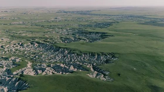
This is a paddling trip through the emptiest, biggest-sky corner of the northern plains. North Dakota strings together a seasonal badlands river, the largest reservoir on the Missouri, and a rare free-flowing stretch of the Missouri itself, all wrapped in the painted buttes, bison, and wild horses of Theodore Roosevelt National Park. It is remote, with few services and long drives, and that is exactly why the rivers feel like they are yours alone.
The centerpiece is a North Dakota canoe trip down the Little Missouri River through the badlands of Theodore Roosevelt NP. This is a remote, seasonal run that is only floatable in spring and early summer high water, usually April into early June. The river is shallow, braided, and runs dry by midsummer, so the whole trip plans around the gauge. Pair the little missouri river canoe run with flatwater paddling on the vast Lake Sakakawea reservoir, the free-flowing Missouri at Cross Ranch State Park, a quiet float on the Sheyenne River, and the Lewis and Clark history that threads it all together.
The best window is late spring to early fall. The Little Missouri only floats in spring high water, while the lakes and the lower Missouri paddle well all summer. Either way this is big, remote country: check the river gauges before you commit, carry far more water and fuel than you think you need, and tell someone your float plan before you push off.
The Little Missouri only floats in spring and early-summer high water, so watch the USGS river gauge and have a flatwater backup if levels drop. Lodging is thin out here: Medora is tiny and fills around Medora Musical nights and summer weekends, so reserve early or base in Watford City and Bismarck. There are long stretches with no gas, no cell service, and no services, so fill up in town, download offline maps, and carry plenty of water.

Fly in & drive to Medora · the painted badlands
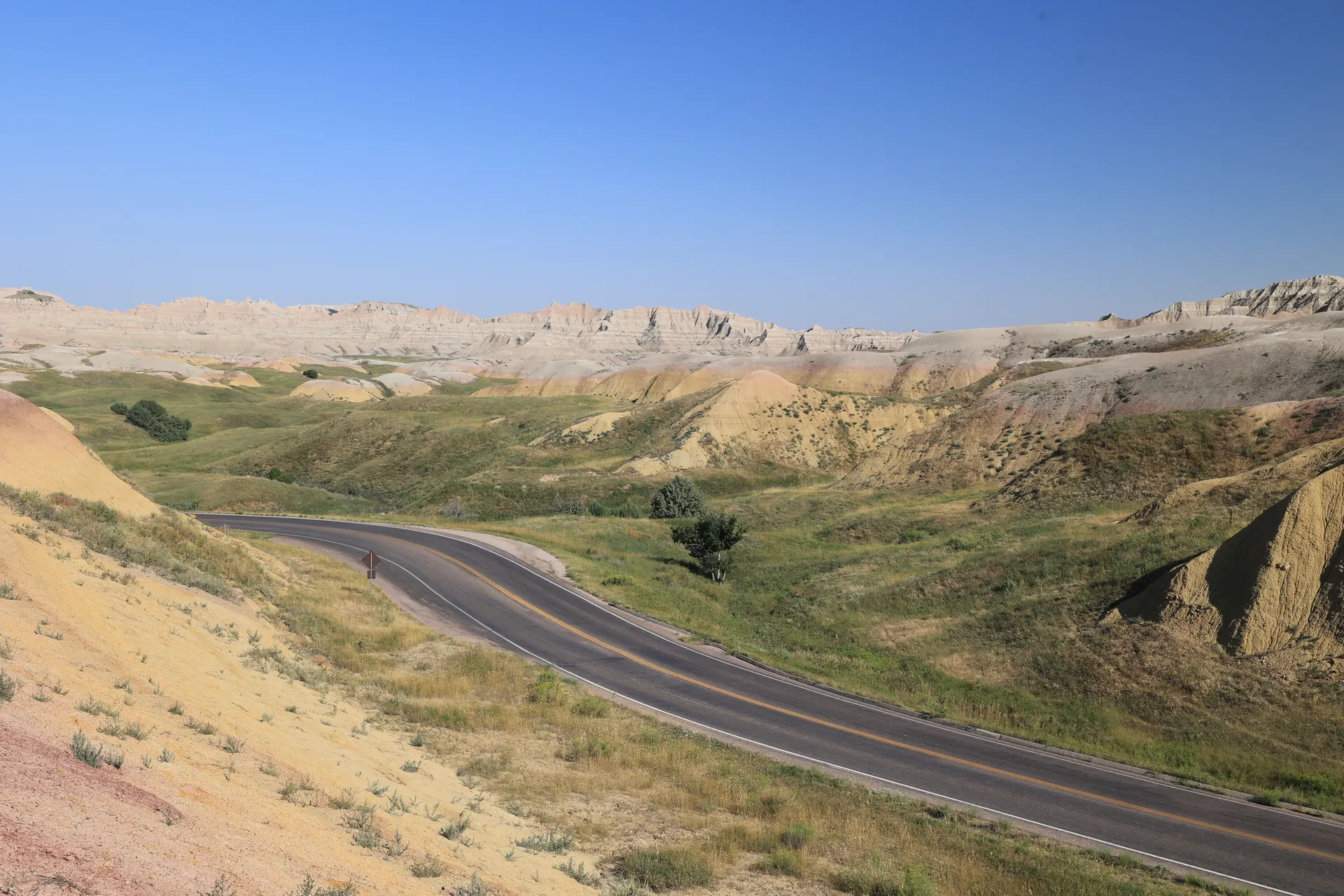
Fly into Bismarck (BIS) or Dickinson (DIK) and point west across the prairie to Medora, the tiny historic gateway to the South Unit of Theodore Roosevelt National Park. It is roughly 2.5 hours from Bismarck or about 35 minutes from Dickinson, through long empty stretches with patchy cell service, so fuel up and download offline maps before you go.
Get your first look at the painted badlands on the South Unit's scenic loop, where banded buttes, bentonite clay, and coal seams glow at golden hour and bison graze along the road. This is the country Theodore Roosevelt fell in love with, and it sets the tone for the rivers and ranches to come. Settle into Medora for the night and check the Little Missouri river gauge for the days ahead.
- South Unit scenic loop · painted badlands · bison along the road
- Drive Bismarck or Dickinson to MedoraBIS ~2.5 hr · DIK ~35 min · fuel up, patchy cell service
- Check the Little Missouri river gaugeSeasonal river · only floats in spring / early-summer high water
- Stay in MedoraTiny park gateway · books up on summer weekends
- The Little Missouri is a seasonal river. Check the USGS gauge near Medora before the trip and have a flatwater backup on Lake Sakakawea or the Missouri if levels are too low.
- Medora is tiny and fills up around Medora Musical nights and summer weekends. Reserve a room early or plan to base in Watford City or Bismarck.
- Fuel up and download offline maps in town. Cell service is patchy and gas stations are far apart out here.

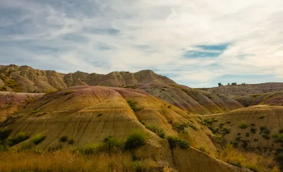
Theodore Roosevelt South Unit · bison, wild horses & the scenic loop
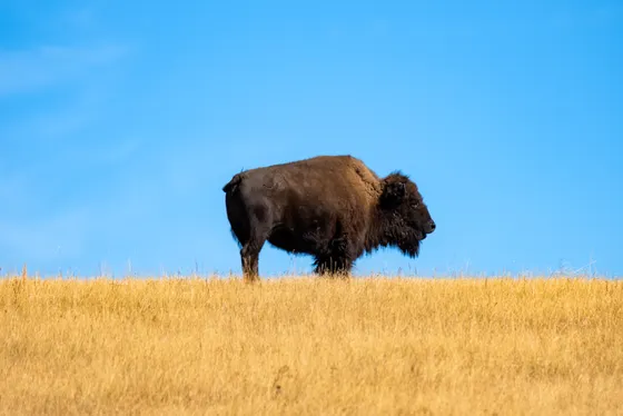
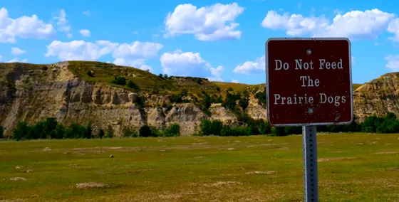
Spend a full day in the South Unit of Theodore Roosevelt National Park, the busier and most accessible of the park's two badlands units. Drive the scenic loop with stops at Wind Canyon over the Little Missouri, the prairie dog towns, and the Painted Canyon overlook, watching for bison and the park's famous bands of wild horses on the ridges.
Stretch your legs on a short badlands hike off the loop to feel the scale of the buttes up close, then scout your Little Missouri put-in for tomorrow if the gauge looks good. This is also the day to dial in your float plan: the river through the park is shallow, braided, and remote, so confirm access, shuttle logistics, and exactly where you will take out before you commit a boat to the water.
- Wind Canyon · Painted Canyon · prairie dog towns · bison & wild horses
- Short badlands hike off the loopFeel the scale of the buttes · easy to moderate options
- Scout the Little Missouri put-inConfirm access, shuttle & take-out before you float
- Second night in MedoraStay put to launch the river run early
- Give bison and wild horses a wide berth. Bison are unpredictable and far faster than they look, so watch from the road or a safe distance.
- Wind Canyon at sunset is the South Unit's best overlook over the Little Missouri. Time the loop so you finish there in the golden hour.
- Confirm your float logistics today: where you put in, where you take out, and how you shuttle. The river through the park is remote with limited access points.
Little Missouri River canoe run · the badlands by water
This is the heart of the trip: a little missouri river canoe run through the badlands. In spring and early-summer high water the Little Missouri becomes a slow, twisting float beneath the painted buttes, with bison on the banks, cottonwood bottoms, and the kind of silence you only get on a remote prairie river. It is shallow and braided even at good flows, so expect to read the channel, drag through riffles, and pick your line carefully.
Because the river is so seasonal, the day lives and dies by the gauge. Only float if levels are up, plan a realistic distance with a clear take-out, and treat this as remote wilderness paddling: there is no cell service, no services, and no quick way out. Carry plenty of water and sun protection, watch the weather (the river rises fast after rain), and tell someone your float plan and expected take-out time before you push off.
- Little Missouri River canoe floatSeasonal high-water run · shallow, braided · remote wilderness paddling
- Only float in adequate flow · tell someone your take-out time
- Carry plenty of water & sun protectionNo services on the river · the prairie sun is relentless
- Night in MedoraBack to base after the take-out and shuttle
- The Little Missouri only floats in spring and early-summer high water and runs dry by midsummer. If the gauge is low, skip it and add a day on Lake Sakakawea or the Missouri instead.
- Even at good flows the river is shallow and braided. Expect to drag through riffles, read the channel, and choose your line, and bring a boat you do not mind scraping.
- This is remote wilderness paddling with no services and no cell signal. The river also rises fast after rain, so watch the weather and file a float plan with someone before you launch.

The Maah Daah Hey Trail · badlands on foot

Trade the paddle for boots and explore the badlands on the legendary Maah Daah Hey Trail, the long single-track that threads more than 140 miles between the South and North Units of the park. You do not need to hike the whole thing: pick a scenic segment for an out-and-back through grasslands, painted buttes, and cottonwood draws, with sweeping views over the Little Missouri country you floated yesterday.
The badlands are exposed, with little shade and few water sources, so start early, carry plenty of water, and watch the weather, because the clay turns to greasy gumbo when it rains. After your hike, ease north along the back roads toward Watford City, the gateway to the park's quieter North Unit and your base for the next leg.
- 140+ mi single-track · pick a scenic out-and-back · badlands & grassland
- Carry plenty of waterExposed trail · little shade · few reliable water sources
- Drive north toward Watford CityGateway to the North Unit · base for the next leg
- Stay in Watford CityNorth Unit gateway · services & lodging
- You do not need to hike the whole Maah Daah Hey. Pick one scenic segment for an out-and-back and turn around when you have had enough.
- Badlands clay becomes slick, sticky gumbo when wet. Avoid the trail right after rain, when it is both treacherous and brutal on boots and tires.
- The trail is exposed with little shade and few water sources. Start early, carry plenty of water, and bring sun protection.
Theodore Roosevelt North Unit · the wilder badlands
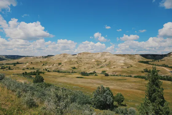
The North Unit of Theodore Roosevelt National Park is the quieter, wilder, and arguably more dramatic of the two, with deeper canyons, the Cannonball Concretions, and longhorn cattle that nod to the area's open-range history. Drive the scenic road out to the Oxbow Overlook, where the Little Missouri makes a sweeping bend far below, and watch for bison and bighorn-style ridgelines along the way.
Walk a short trail off the scenic road to get down among the buttes, then take in the bigger-picture view of the river you canoed and the country it carves. The North Unit sees a fraction of the South Unit's visitors, so this is the day to slow down, soak up the badlands quiet, and overnight again in Watford City before turning toward the big water of Lake Sakakawea.
- Deeper canyons · Cannonball Concretions · the Little Missouri's big bend
- Short trail off the scenic roadGet down among the buttes · easy to moderate
- Watch for bison & longhornsQuieter unit · open-range history
- Second night in Watford CityBase before the drive to Lake Sakakawea
- The North Unit is about an hour and a half north of the South Unit and sees far fewer people. Allow the drive time and enjoy having the overlooks nearly to yourself.
- Oxbow Overlook at the end of the scenic road is the North Unit's signature view over a big bend of the Little Missouri. Save it for late afternoon light.
- Look for the Cannonball Concretions, spherical sandstone boulders weathered out of the cliffs, on a short walk off the scenic road.
Lake Sakakawea · flatwater paddling on the big reservoir


Drive southeast to Lake Sakakawea, the huge Missouri River reservoir behind Garrison Dam and one of the largest man-made lakes in the country. After days on a shallow, braided river, the scale is a shock: open horizons of blue water, sandy bluffs, and wide bays where you can spend a quiet morning flatwater paddling close to shore.
This is a different kind of canoeing, calm and meditative when the wind is down, but the lake is enormous and squalls build fast, so paddle in the morning, hug the shoreline, and get off the water if whitecaps appear. Use one of the state recreation areas managed by North Dakota Parks and Recreation for an easy launch, a beach, and a campsite or cabin for the night on the Lewis and Clark route.
- Flatwater paddle on Lake SakakaweaHug the shoreline · paddle in the morning · off the water in wind
- State rec areas on the reservoir · launches, beaches, campsites & cabins
- Watch the wind & wear a PFDBig open water · squalls build fast · stay close to shore
- Lewis and Clark countryThe expedition's route up the Missouri ran through here
- Lake Sakakawea is enormous open water and the wind can whip up whitecaps quickly. Paddle in the calm of early morning, stay close to shore, and get off the water if it builds.
- Always wear a PFD on the reservoir. Cold water and sudden wind make big lakes more serious than they look on a calm morning.
- Use a North Dakota Parks and Recreation area for an easy launch, a beach, and a place to camp or grab a cabin for the night.
Lewis and Clark history · Fort Mandan & the Missouri
Trace the Lewis and Clark route along the Missouri as it bends through central North Dakota. The Corps of Discovery wintered here in 1804 to 1805, and it was near these villages that the expedition met Sakakawea, the Lemhi Shoshone woman whose name the great reservoir now carries. Visit the reconstructed Fort Mandan and the nearby Knife River Indian Villages to stand where one of the most famous journeys in American history paused for a long northern-plains winter.
Break up the history with an easy paddle on a calm stretch of the Missouri or a quiet reservoir bay, keeping a flexible, weather-driven pace. Then drive on toward Bismarck, the state capital and your hub for the free-flowing river and Sheyenne paddling to come. Bismarck has the trip's best range of lodging, food, and an outfitter or two to resupply.
- Fort Mandan & Lewis and Clark sitesReconstructed winter fort · Knife River Indian Villages nearby
- Easy paddle on the MissouriCalm stretch or reservoir bay · flexible, weather-driven pace
- Drive to BismarckState capital · best lodging, food & outfitters · trip hub
- Stay in BismarckResupply and base for the lower-Missouri leg
- The Corps of Discovery wintered near here in 1804 to 1805 and met Sakakawea, whose name the reservoir carries. Fort Mandan and the Knife River Indian Villages tell that story well.
- Use Bismarck to resupply. It has the best range of groceries, gear, lodging, and food on the whole route, so stock up before the next paddling days.
- Keep the pace flexible. On a big-river trip, the weather and wind decide how far you paddle, so build in slack and do not force a set mileage.
Cross Ranch State Park · the free-flowing Missouri
Drive up to Cross Ranch State Park, set on one of the last free-flowing, undammed stretches of the Missouri River. Unlike the slack water of the reservoirs, the river here still moves, braids around wooded islands, and rolls past old cottonwood bottoms much as it did in the expedition's day, which makes it one of the most rewarding canoe paddles in the state.
Put in for a downstream float along the park, drifting past sandbars and islands with good odds of spotting deer, beaver, and bald eagles. Because it is a moving river, plan a one-way float with a shuttle and account for the current. The state park, run by North Dakota Parks and Recreation, has riverside campsites and cabins, miles of nature trails through the bottomland forest, and an adjacent nature preserve where bison roam.
- Float the free-flowing MissouriMoving water · braided around wooded islands · one-way float with shuttle
- Riverside campsites & cabins · bottomland trails · adjacent bison preserve
- Watch for eagles, deer & beaverWooded islands & sandbars · rich river wildlife
- Plan the shuttle & currentMoving river · arrange a take-out and account for the flow
- Cross Ranch sits on one of the last undammed stretches of the Missouri. Unlike the reservoirs, the current does the work, so plan a one-way float with a shuttle back to your car.
- Account for the moving water and pick a realistic distance. The river is gentle but it is still a big channel with sandbars and islands to read.
- The state park has riverside campsites and cabins through North Dakota Parks and Recreation, plus bottomland trails and an adjacent preserve where bison roam.
The Sheyenne River · a quiet prairie float
For a complete change of pace, head east to the Sheyenne River, a small, slow, tree-lined prairie stream that winds through a wooded valley in the otherwise open farmland of eastern North Dakota. After the badlands and the big Missouri, the Sheyenne is intimate and gentle: a shady, meandering float with overhanging trees, easy current, and the kind of birdsong you only hear on a quiet river.
Pick a mellow segment for a relaxed half-day paddle, keeping an eye on the gauge since the smaller river can run thin in late summer. It is the perfect low-key day to wind the trip down, before circling back toward Bismarck for your final night and the flight home tomorrow. Check North Dakota Parks and Recreation for access points and nearby state parks along the river valley.
- Float a Sheyenne River segmentSmall, slow, tree-lined prairie stream · relaxed half-day paddle
- River access points & state parks along the Sheyenne valley
- Check the gaugeSmaller river can run thin in late summer
- Drive back toward BismarckWind down · position for the flight home tomorrow
- The Sheyenne is intimate and gentle, the opposite of the big Missouri. Pick a mellow segment and take it slow for an easy wind-down day.
- Watch the gauge: the Sheyenne is small and can run shallow in late summer. Choose a segment with enough water or save it for higher flows.
- Look for river access and state parks along the Sheyenne valley through North Dakota Parks and Recreation to plan your put-in and take-out.
Last paddle & fly home from Bismarck
Squeeze in one last easy paddle on a calm stretch of the Missouri or a quiet reservoir bay near Bismarck, the perfect quiet farewell to ten days on North Dakota water. Watch the sun come up over the river, take a final look at the big-sky country, and dry your gear before you pack the boat away.
Then it is back to Bismarck (BIS) for the flight home, or the roughly 1.5-hour drive west to Dickinson (DIK) if you booked out of there. Fuel up, return any rentals or shuttles, and leave with time to spare, because out here the airport is small and the prairie roads are long. You will be planning the next high-water spring before you land.
- Final easy paddle near BismarckCalm Missouri stretch or reservoir bay · a quiet farewell
- Sunrise over the riverLast big-sky view before you pack up
- Fly home: Bismarck or DickinsonBIS in town · DIK ~1.5 hr west · fuel up, leave early
- Keep the last paddle short and easy on calm water so you have plenty of time to dry gear and make your flight.
- Bismarck (BIS) is the most convenient fly-out. Dickinson (DIK) is about an hour and a half west and may suit a route that ends near the badlands.
- Fill up, return any shuttles or rentals, and leave early. The airports are small and the prairie drive is longer than it looks.
Now build your North Dakota canoe trip.
You've seen all ten days. Open the free drag-and-drop planner and tune it for your dates, the river flows, and whether you base in Medora, Watford City, or Bismarck.
What we actually learned on the rivers.
The Little Missouri is seasonal, plan around the gauge
The Little Missouri River canoe run only floats in spring and early-summer high water, usually April into early June, and runs dry by midsummer. Watch the USGS gauge near Medora and always have a flatwater backup on Lake Sakakawea or the Missouri if levels are too low.
Pay the entrance fee or bring your pass
Theodore Roosevelt National Park charges about $30 per vehicle for a 7-day pass covering both the South and North Units. The annual America the Beautiful pass ($80) also covers entry and pays off fast if you visit other parks. Pay at the entrance or online ahead.
Plan shuttles for one-way river floats
River paddling on the Little Missouri and the free-flowing Missouri at Cross Ranch is one-way and downstream, so you need a shuttle or a second vehicle at the take-out. Confirm access points and take-out times before you launch, because services are sparse out here.
Mind the wind on the big reservoirs
Lake Sakakawea is enormous open water where squalls build fast and whitecaps come up quickly. Paddle in the calm of early morning, hug the shoreline, always wear a PFD, and get off the water the moment the wind picks up.
Fuel up and expect few services
This is remote, big-sky country with long empty stretches, sparse gas, and patchy cell service. Fill up in Medora, Watford City, or Bismarck before every leg, download offline maps, and carry far more water than you think you need.
Lodging is thin, so book early
Medora is tiny and fills up around Medora Musical nights and summer weekends. Reserve early or base in Watford City for the North Unit and Bismarck for the lower-Missouri legs. State parks like Cross Ranch and the Lake Sakakawea recreation areas offer riverside campsites and cabins through North Dakota Parks and Recreation.
Everything you'll actually want to know.
Ready to go? Get your
North Dakota canoe route.
Put-ins and take-outs, the seasonal river gauge to watch, reservoir launches, shuttle logistics, lodging in Medora, Watford City, and Bismarck, and the drive times you need to paddle North Dakota safely.
Instant book · Free cancellation · Secure payment via Stripe

Planning this trip?
Save it, share it with your crew, or find travelers heading the same way.

Liked this itinerary?
What other travelers are saying
Be the first to leave a tip or question for the next traveler.