Louisiana Wetlands Circuit:
A 10-Day Itinerary
A 10-day loop through south Louisiana's bayous and Cajun country: Atchafalaya Basin airboats, Lake Martin's cypress swamp, Jean Lafitte, New Orleans, Avery Island, the Creole Nature Trail, Kisatchie, and Grand Isle.
Free interactive planner · drag & reorder your days, add stops, map it in minutes
Build your own Louisiana wetlands trip, drag, reorder & map it.
Drag stops between days, swap swamp tours, and add your own bayous and birding spots with the place search. The live map and drive times recalculate as you go, so you can balance the long marsh-country legs against the days you want close to New Orleans or Lafayette.
Opens a side panel · reorder days, add custom stops, see your route live
One state, swamps, marshes & Cajun country, all in south Louisiana.
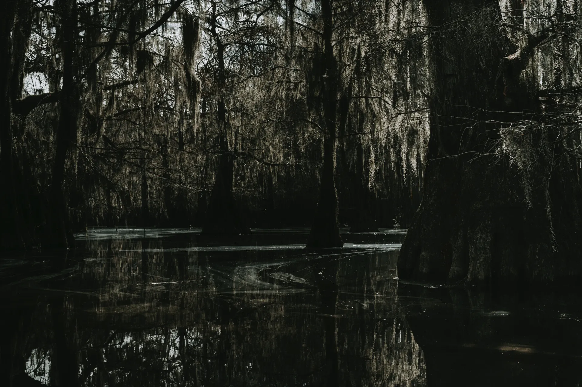
South Louisiana is a water world. Below Interstate 10 the land dissolves into bayous, cypress-tupelo swamps, and Gulf marshes that stretch to the horizon, stitched together by Cajun and Creole towns where the food, the music, and the accents are unlike anywhere else in America. This 10-day loop is a true louisiana swamp tour itinerary, built around the best wetlands the state has, with airboats, boardwalks, and birding rookeries at every turn.
You will base in three hubs, New Orleans, Lafayette, and Houma, and circle out to the Atchafalaya Basin (the largest river swamp in the country), Lake Martin near Breaux Bridge, the Barataria Preserve of Jean Lafitte, Avery Island, the Creole Nature Trail, the longleaf pine of Kisatchie National Forest, and the Gulf at Grand Isle. Expect alligators, herons, egrets, and roseate spoonbills along the way.
Go October through April. South Louisiana heat and humidity are intense, and summer is brutal and buggy out on the water, with mosquitoes that can ruin a swamp tour. Hurricane season runs June through November, so watch the forecast if you travel in late summer or fall. Spring brings nesting birds to the rookeries; winter is mild, quiet, and one of the best times to be in the marsh.
Swamp tours fill up fast on spring and fall weekends, so reserve your Atchafalaya airboat tour ahead of time. Lodging on the coast at Grand Isle is limited and books out for fishing and festival weekends. New Orleans hotels spike hard around Mardi Gras, Jazz Fest, and big events, so lock in those nights early and watch the hurricane forecast in late summer and fall.
Arrive New Orleans · City Park & the bayou
Fly into New Orleans (MSY) and ease into the trip in the city itself, which sits in a bowl below sea level wrapped in water. Spend the afternoon in City Park, 1,300 acres of moss-draped live oaks, lagoons, and Bayou Metairie, then wander the historic neighborhoods and eat your first proper bowl of gumbo. New Orleans is the wettest big city in America, and it makes the perfect soft landing before you head into the swamps.
Walk or paddle a stretch of Bayou St. John, the slow tidal waterway that threads from City Park toward Lake Pontchartrain and gave the early city its back door to the Gulf. Get to bed early, because the best wildlife and the coolest, calmest water are first thing in the morning, which is exactly when you want to be on a swamp tour over the next few days.
- City Park & Bayou Metairie1,300 acres · moss-draped oaks, lagoons · easy strolling
- Bayou St. JohnSlow tidal bayou · walk, bike, or paddle toward Lake Pontchartrain
- Eat your first gumboCreole cooking · the wettest big city in America
- Stay in New OrleansBase here for the first three nights of the loop
- New Orleans (MSY) is the easiest gateway for this loop; Lafayette (LFT) works well if you would rather start in Cajun country and run the route the other way.
- City Park is free to wander and has the largest stand of mature live oaks in the world, many draped in Spanish moss right in the middle of the city.
- Heat and humidity build fast by midday in any season, so plan your outdoor time for early morning and use afternoons for food, music, and air conditioning.
Jean Lafitte · Barataria Preserve boardwalks
Drive about 40 minutes south of the city to the Barataria Preserve, the wetlands unit of Jean Lafitte National Historical Park and Preserve. Nine miles of boardwalks and trails carry you through hardwood forest, cypress swamp, and freshwater marsh, the same drowned delta country that once hid the pirate Jean Lafitte. It is the easiest, closest place to walk straight into a real Louisiana swamp without getting on a boat.
Go early and walk quietly. The boardwalks are prime alligator and wading-bird habitat, and you have a good chance of spotting gators, herons, egrets, and turtles along the Bayou Coquille and Marsh Overlook trails. Back in the city, spend the evening in the French Quarter or catch live music; you have an early swamp-tour start coming up.
- ~9 mi of boardwalks & trails · swamp, marsh & hardwood forest
- Bayou Coquille & Marsh Overlook trailsBoardwalk loop · gators, herons, egrets, turtles · go early
- French Quarter eveningLive music & Creole dinner back in the city
- Second night in New OrleansSame base · easy day trip south to Barataria
- The Barataria Preserve is free to enter; check the Jean Lafitte planning page for current trail and boardwalk conditions, as sections close after storms.
- Stay on the boardwalks and keep your distance from alligators. They are wild and common here, and you should never feed or approach them.
- Bring insect repellent year round. The marsh has mosquitoes even on cool days, and they are relentless in the warm months.
New Orleans to Houma · into bayou country
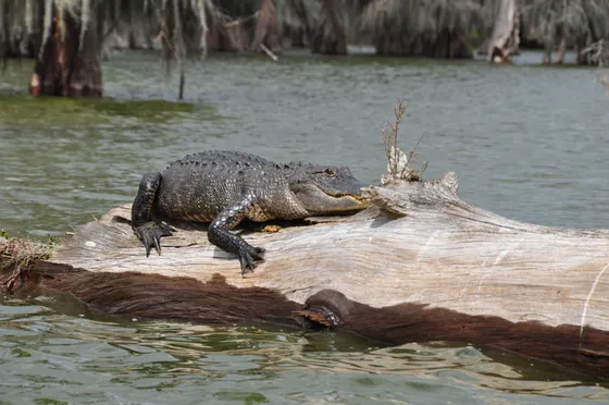
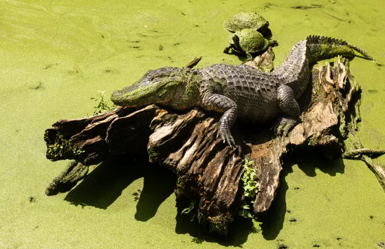
Leave New Orleans and drive about an hour southwest to Houma, the heart of bayou country where the land truly gives way to water. This stretch of Terrebonne and Lafourche parishes is laced with bayous, and it is the classic place to take a slow, narrated swamp boat tour through the cypress and Spanish moss, watching for alligators basking on the banks.
Spend the afternoon learning how Cajun communities live on the water here, from shrimp boats to camps built on stilts. Houma makes a relaxed base between the New Orleans days and the Cajun-country days to come, and it puts you within easy reach of both the coast and the Atchafalaya without backtracking through the city.
- Houma swamp boat tourNarrated bayou cruise · cypress, Spanish moss & basking gators
- Drive New Orleans to Houma~1 hr southwest · into Terrebonne & Lafourche bayou country
- Bayou life & shrimp boatsCamps on stilts · working Cajun water communities
- Stay in HoumaBayou-country base · close to the coast & the Atchafalaya
- Houma sits where roads start running out and bayous take over; it is a great low-key base if you want bayou tours without the New Orleans crowds and prices.
- Morning swamp tours are cooler, calmer, and far better for spotting wildlife than afternoon ones, especially in the warm months.
- Alligators are most active and visible when water and air are warm; on cool winter days they may be hidden, so manage expectations in December and January.
Houma to Lafayette · the Atchafalaya Basin

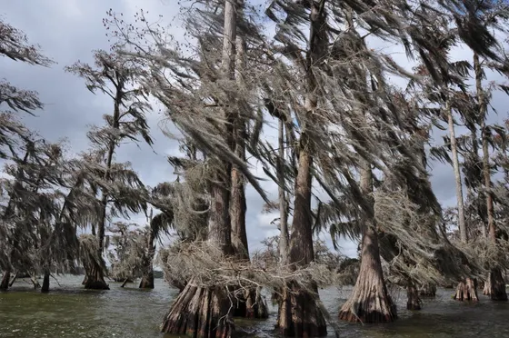
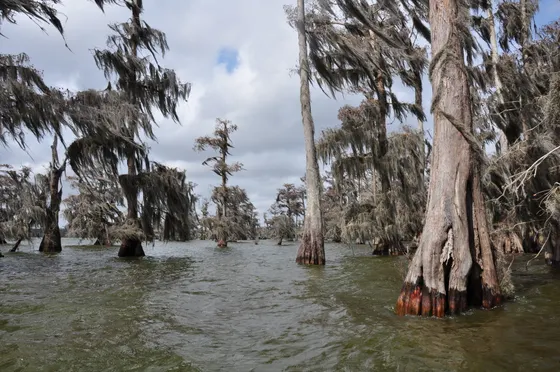
Drive northwest into the Atchafalaya Basin, the largest river swamp in the United States and the wild green heart of this whole trip. Nearly a million acres of bottomland hardwood, cypress-tupelo swamp, and bayou spread out where the Atchafalaya River carries a third of the Mississippi's water to the Gulf. It is one of the great wetlands of North America, and the best way to feel its scale is from the water.
Book a swamp or airboat tour from Basin Landing at Henderson, on the basin's edge. An airboat skims you out across open water and back into flooded cypress where the moss hangs to the surface, with strong odds of alligators, herons, and egrets. Afterward, continue into Lafayette, the capital of Cajun country and your base for the next several days.
- Airboat into the Atchafalaya from Henderson · gators & wading birds · book ahead
- Atchafalaya BasinLargest river swamp in the US · ~1 million acres of cypress & bayou
- Drive Houma to Lafayette~1.5 hr northwest · via the Atchafalaya & Henderson
- Stay in LafayetteCapital of Cajun country · base for the next several nights
- Reserve the Basin Landing airboat or swamp tour in advance, especially on spring and fall weekends when slots sell out.
- Airboats are loud and fast; bring ear protection if you are sensitive to noise, and a hat and sunglasses for the open-water runs.
- The Atchafalaya Welcome Center near Butte La Rose is a worthwhile free stop for context on the basin's ecology before or after your tour.
Lake Martin & Breaux Bridge · cypress rookery
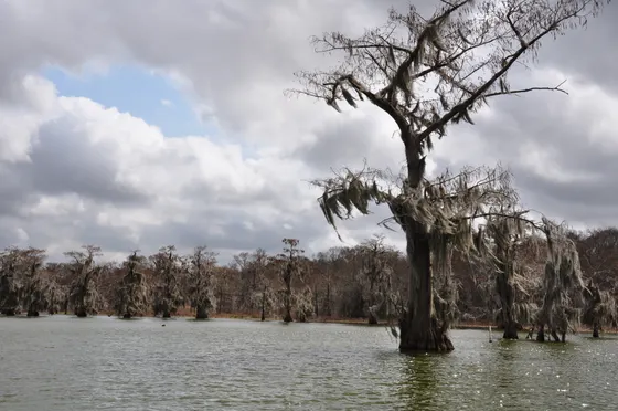
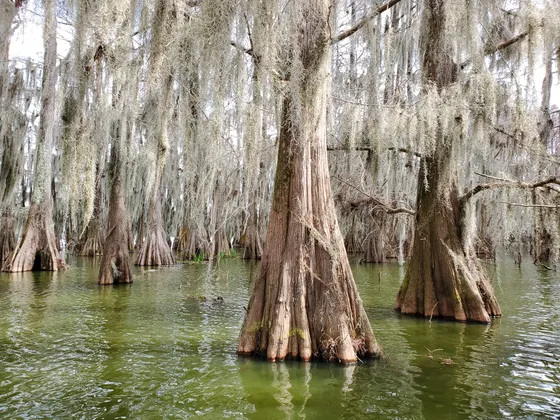
Just outside Breaux Bridge, Lake Martin is one of the most beautiful and accessible cypress-tupelo swamps in Louisiana, a small lake ringed by bald cypress where you can walk a levee trail right at the water's edge. In late winter and spring it hosts a major wading-bird rookery, with thousands of egrets, herons, and roseate spoonbills nesting in the cypress over water full of alligators.
Take an early morning boat tour or simply walk the rookery road for some of the best swamp photography in the state. Then spend the afternoon in Breaux Bridge and Lafayette soaking up Cajun and Creole culture, from a plate of boudin to a zydeco dance hall. This is the cultural heart of the trip, where the wetlands and the music run together.
- Lake Martin cypress swampBald cypress lake near Breaux Bridge · levee walk at the water's edge
- Wading-bird rookeryLate winter to spring · egrets, herons & roseate spoonbills nesting
- Boudin & a zydeco hallBreaux Bridge & Lafayette · Cajun and Creole food and music
- Second night in LafayetteSame base · short hop out to Lake Martin
- Lake Martin's rookery is busiest from roughly February through May; outside nesting season the birds disperse, though you can still see gators and cypress year round.
- The rookery road along the lake closes seasonally to protect nesting birds, so check current access before you go and use the levee trail and boat tours instead.
- Try real Cajun boudin from a meat market or gas station deli, the classic way to eat it, and look for an afternoon zydeco or Cajun dance in or around Lafayette.
Avery Island · Tabasco & Jungle Gardens
Head about 30 minutes south of Lafayette to Avery Island, a salt-dome island rising out of the marsh that is home to the Tabasco factory and the lush Jungle Gardens. Tour how the famous pepper sauce is made and aged, then drive the gardens' quiet roads through bamboo, live oaks, and lagoons that wind down to Bird City, an egret rookery the McIlhenny family founded to save the snowy egret from plume hunters more than a century ago.
In spring, thousands of egrets nest on platforms over the water here, an unforgettable wildlife spectacle. Watch for alligators in the lagoons too. It is an easy, low-effort wildlife day, perfect for pairing a swamp circuit with a taste of the culture and history that make Cajun country unique. Return to Lafayette for the night.
- Tabasco factory tourAvery Island salt dome · see the pepper sauce made and aged
- Jungle Gardens & Bird CityDrive through bamboo, oaks & lagoons · historic egret rookery
- Egrets & marsh gatorsSpring nesting spectacle over the water · gators in the lagoons
- Back to Lafayette~30 min each way · third night at your Cajun base
- Avery Island charges a small admission for the factory and gardens; you can buy a combined ticket and easily spend a half day on the island.
- Bird City's egret rookery is at its best in spring, when thousands of birds nest on the platforms; in winter it is much quieter.
- Drive the Jungle Gardens slowly with your windows down and watch the lagoon edges for alligators sunning themselves.
The Creole Nature Trail · Gulf marshes & gators
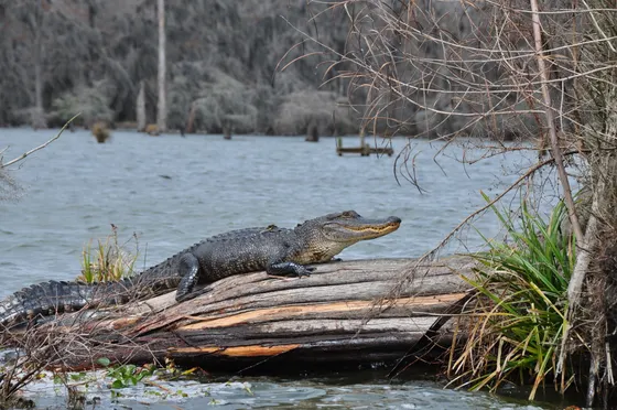
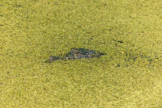
Drive west to the Creole Nature Trail, an All-American Road that loops through the vast Gulf marshes of southwest Louisiana, sometimes called the state's outback. The route threads through several national wildlife refuges, including Cameron Prairie, where boardwalks and a wildlife drive put you among alligators, wading birds, and some of the best birding on the Gulf Coast.
This is open marsh country very different from the cypress swamps: wide skies, brackish water, and shorebirds by the thousand on migration. Cameron Prairie's Wetland Walkway is a short boardwalk loop where alligators are nearly guaranteed in warm weather. With long drives between stops and few services, fuel up and pack water, then base for the night in Lafayette or Lake Charles.
- Creole Nature Trail All-American RoadLoop through southwest Louisiana's Gulf marshes & wildlife refuges
- Cameron Prairie NWRWetland Walkway boardwalk & wildlife drive · gators & wading birds
- Gulf Coast birdingOpen brackish marsh · shorebirds, spoonbills & migrants
- Stay in Lafayette or Lake CharlesLong marsh-country drives · fuel up & carry water
- The Creole Nature Trail covers a lot of remote marsh; fill your tank, bring water and snacks, and download maps, because services and cell signal are thin.
- Cameron Prairie's Wetland Walkway is a short, flat boardwalk loop that is one of the most reliable places in the state to see wild alligators up close from a safe distance.
- Spring and fall migration bring huge numbers of shorebirds and waterfowl to these marshes; bring binoculars and a bird guide for the best of it.
Kisatchie National Forest · longleaf pine
For a change of texture, drive north to Kisatchie National Forest, the only national forest in Louisiana, where the wetlands give way to rolling longleaf pine hills, sandstone bluffs, and clear creeks. The Kisatchie Ranger District and the Longleaf Vista area show off the rare pine-savanna country that once covered much of the Gulf South, with overlooks and trails that feel a world away from the bayous.
Hike the Longleaf Vista Trail or part of the Wild Azalea Trail, the state's longest, through pine and hardwood with spring wildflowers and good birding for woodpeckers and warblers. It is the highest, driest, and most forested day of the loop, a reminder that Louisiana is far more than swamp. Overnight near the forest or back toward Lafayette as you start the swing back south.
- Louisiana's only national forest · longleaf pine, bluffs & creeks
- Longleaf VistaOverlooks & trails through rare pine-savanna country
- Wild Azalea TrailThe state's longest trail · pine, hardwood & spring wildflowers
- Overnight near the forest or LafayetteHighest, driest day of the loop · start the swing back south
- Check the Kisatchie forest site for trail and road conditions and any seasonal closures before you go, as the forest spans several scattered districts.
- Spring brings wild azaleas and dogwoods in bloom along the trails; fall is cooler and pleasant for longer hikes once the swamp-country heat eases.
- This is the one day you trade bayous for pine uplands, so it is a good buffer day if heat, bugs, or rain have worn you down in the marsh.
Grand Isle · the Gulf barrier island
Swing south and east to Grand Isle, Louisiana's only inhabited barrier island, a thin strip of sand and marsh at the very edge of the state where the bayous finally meet the open Gulf. The drive down Bayou Lafourche past shrimp boats and fishing camps is a journey through working Cajun coast, and the island itself is famous for its beaches, its fishing, and especially its birding.
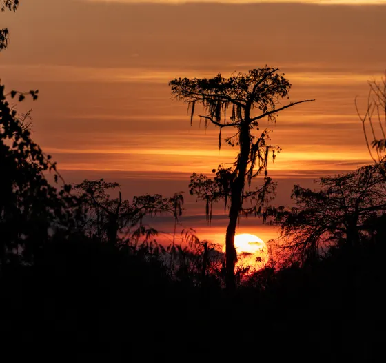
Walk the beach and the trails at Grand Isle State Park, and in spring time your visit for migration, when the island's live-oak groves fill with exhausted songbirds making landfall after crossing the Gulf, one of the great birding events in North America. This is the wild, weathered far end of the wetlands circuit, a fitting place to watch a Gulf sunset before you turn back toward the city.
- Grand Isle & the open GulfLouisiana's only inhabited barrier island · beaches & fishing
- Grand Isle State Park birdingSpring migration fallouts in the live-oak groves · world-class
- Drive down Bayou LafourcheShrimp boats & fishing camps · the working Cajun coast
- Stay on Grand Isle or in HoumaLimited island lodging · books out for fishing weekends
- Grand Isle lodging is limited and fills for fishing rodeos, the spring Migratory Bird Festival, and summer weekends, so book ahead or base in Houma and day-trip.
- Time a spring visit for a migration fallout if you can; on the right April morning the island's oak groves can be dripping with warblers, tanagers, and buntings.
- This far down the coast is exposed to storms and tides; check the weather and road conditions on LA 1, which can flood, before committing to the drive.
Back to New Orleans · last bayou & fly out
Close the loop with the drive back up to New Orleans, roughly two to three hours from Grand Isle depending on stops. If your flight allows, fit in one last short bayou walk or a final plate of gumbo and a beignet in the city before you head to the airport. Ten days in, you will read the water and the moss-hung trees very differently than you did on day one.
Getting home: fly out of New Orleans (MSY), or, if you ran the loop the other direction, from Lafayette (LFT). Leave a comfortable cushion for the drive up from the coast, since LA 1 and the bayou-country roads can be slow and occasionally flood. From swamp to marsh to pine and back to the city, you have just traced the full sweep of wet Louisiana.
- Drive Grand Isle to New Orleans~2–3 hr back up through bayou country to the city
- Last gumbo & a beignetOne more bowl & a final bayou walk if your flight allows
- Fly out: MSY or LFTNew Orleans (MSY), or Lafayette (LFT) if you ran the loop reversed
- Build in extra time for the drive up from Grand Isle; LA 1 and other low coast roads can flood on high tides or after rain.
- If you would rather not backtrack, this loop runs just as well in reverse out of Lafayette (LFT), ending your wetlands days closer to your flight home.
- Save a little appetite and budget for the city on your last day; New Orleans food is a fitting end to a trip built around water and Cajun-Creole culture.
Now build your Louisiana wetlands trip.
You've seen all ten days. Open the free drag-and-drop planner and tune it for your dates, your pace, and whether you base in New Orleans, Lafayette, or Houma.
What we actually learned in the bayou.
Go October through April
South Louisiana heat and humidity are intense, and summer is brutal and buggy out on the water. October through April brings comfortable days, fewer mosquitoes, and the best wildlife viewing. Spring adds nesting birds at the rookeries; winter is mild, quiet, and surprisingly good in the marsh.
Watch the hurricane forecast
Hurricane season runs June through November. If you travel in late summer or fall, watch the tropical forecast closely, especially for coastal stops like Grand Isle and the Creole Nature Trail, and keep a flexible day or two in case a system moves in.
Take morning swamp tours
Book swamp and airboat tours for early morning when the water is calm, the air is cooler, and alligators and wading birds are most active and visible. Reserve ahead on spring and fall weekends, when the popular Atchafalaya tours from Henderson sell out.
Pack for bugs and sun
Mosquitoes are a constant in the wetlands, even on cool days, so bring strong repellent and lightweight long sleeves. Add sunscreen, a hat, and sunglasses for open-water airboat runs and the exposed Gulf marshes, where there is almost no shade.
Plan for long, remote drives
The Creole Nature Trail, the lower bayous, and Grand Isle involve long stretches with few services and thin cell signal. Fuel up, carry water and snacks, and download offline maps. Coastal roads like LA 1 can flood, so check conditions before you commit to the drive.
Respect the wildlife
Alligators are wild and common here. Never feed or approach them, keep a safe distance on boardwalks and levees, and watch children and pets near the water. At the bird rookeries, stay back from nesting colonies so you do not disturb them, and follow seasonal closures.
Everything you'll actually want to know.
Ready to go? Get your
Louisiana wetlands route.
Swamp-tour stops and outfitters, the Atchafalaya airboat booking, boardwalks and rookeries, drive times between New Orleans, Lafayette, Houma, and the coast, and the season and bug timing you need to do south Louisiana right.
Instant book · Free cancellation · Secure payment via Stripe


Planning this trip?
Save it, share it with your crew, or find travelers heading the same way.

Liked this itinerary?
What other travelers are saying
Be the first to leave a tip or question for the next traveler.