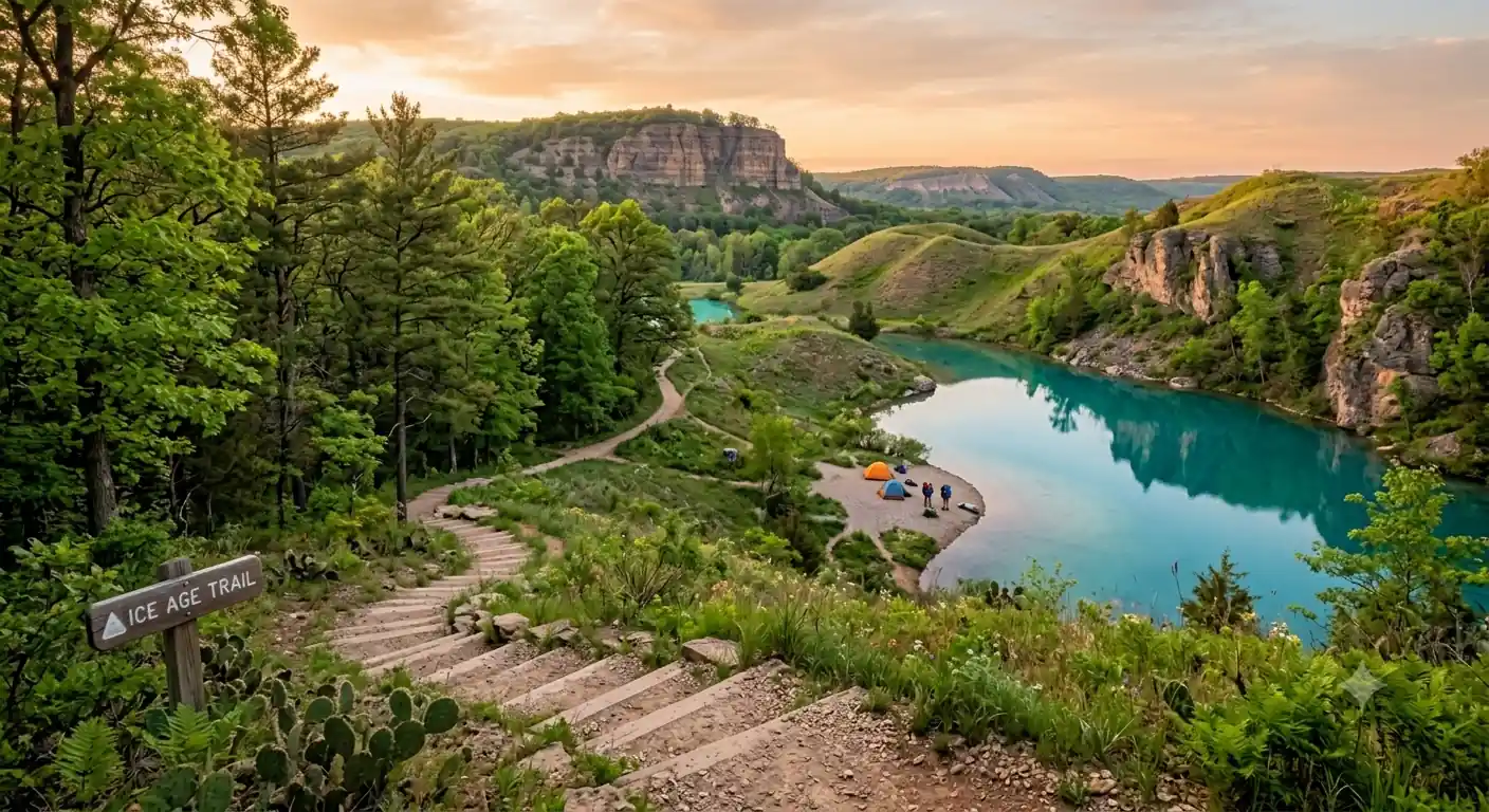
Ice Age Trail Map +
6-Day Kettle Moraine Backpacking Itinerary
6-day, ~60-mile backpacking itinerary on the Kettle Moraine section of Wisconsin's Ice Age National Scenic Trail. From Lapham Peak south through the Southern Unit's kames, kettles, and eskers, camping at state campgrounds and reservable backcountry sites.
Free interactive planner · drag & reorder your days, add stops, map it in minutes
Build your own Ice Age Trail trip, drag, reorder & map it.
Drag stops between days, swap segments, and add your own trailheads and campgrounds with the place search. The live map and trail legs recalculate as you go, so you can tune the Kettle Moraine route to your pace and shuttle logistics before you head out.
Opens a side panel · reorder days, add custom stops, see your route live
Sixty miles of glacial landscape, through the Kettle Moraine.
The Ice Age National Scenic Trail traces the terminal moraine of the last glacier across Wisconsin, a 1,200-mile path through unique geological formations. This 6-day itinerary focuses on the Kettle Moraine section, the most dramatic and hikeable stretch of that glacially sculpted landscape.
You cover roughly 60 miles over six days, averaging about 10 miles a day with a full pack. The route runs from Lapham Peak, the highest point in Waukesha County, south through the Southern Unit of the Kettle Moraine State Forest, past classic kames, kettles, and eskers, with nights split between developed campgrounds and reservable backcountry sites.
Backcountry camping in the Southern Kettle Moraine requires a permit reserved in advance through the Wisconsin DNR, plus a Wisconsin State Park pass for vehicle entry. May, September, and October offer the best hiking, cool temperatures, drier trails, and far fewer mosquitoes and ticks than the humid summer.
Backcountry camping permits for the Southern Kettle Moraine, plus Ottawa Lake and Whitewater Lake campground sites, are reserved through the Wisconsin DNR (wisconsin.goingtocamp.com). Book 3–6 months ahead for peak season (May–October); weekends fill first. Every vehicle also needs a Wisconsin State Park pass (daily or annual). This is a point-to-point hike, so arrange a shuttle or two-car system before you start.
Lapham Peak to Whitewater Lake · 11 miles
Begin at Lapham Peak, the highest point in Waukesha County, about an hour from Milwaukee's airport. After a final gear check and a look from the observation tower, head south on the marked Ice Age Trail through rolling hills and woodlands. Your destination is the Whitewater Lake Campground, reached directly from the trail.
The day starts with a steady descent off Lapham Peak into varied terrain, then works toward Whitewater Lake with water refills at designated points. Carry enough capacity for the full 11 miles, reliable water can be spaced out. Display a Wisconsin State Park pass on your vehicle at the trailhead lot.
- ~1 hr from Milwaukee (MKE) · WI State Park pass required
- 11 mi · 6–7 hr · rolling hills · follow yellow blazes
- Potable water & restrooms · reservations recommended
- Do your final gear check and pack adjustments at the Lapham Peak lot; it is the last developed trailhead before you commit to the day.
- Water sources can be spaced out. Carry 3–4 liters of capacity and top off at every reliable, designated point.
- Follow the yellow blazes on trees (and occasional posts in prairie areas). The Ice Age Trail is well marked once you are on it.
Yellow blazesWhitewater LakeWhitewater Lake to John Muir Trailhead · 10 miles
Follow the blazesGlacial terrainDepart Whitewater Lake and continue south into the heart of the Southern Kettle Moraine State Forest. Today's hike showcases classic glacial formations, kames, kettles, and eskers, with continuous but manageable elevation changes that make a solid workout.
The morning mixes open fields and dense forest; the afternoon brings more pronounced glacial features. Your overnight is a designated backcountry campsite near the John Muir Trailhead. These primitive sites require a permit reserved in advance and have no amenities beyond a cleared tent pad.
- 10 mi · 5–6 hr · kames, kettles & eskers
- Site-specific · reserved in advance via WI DNR
- Primitive · no water or restrooms · Leave No Trace
- Have your backcountry permit printed or saved offline. Permits are site-specific and rangers do check them.
- Backcountry sites have no potable water, so filter or treat from natural sources and carry enough to reach camp.
- Book 3–6 months ahead for peak season (May–October); the most popular sites and weekends go first.
John Muir Trailhead to Scuppernong · 10 miles
From the John Muir Trailhead, continue north on the Ice Age Trail through some of the Southern Unit's most diverse ground, prairies, oak savannas, and wetlands. Sections can be exposed, so sun protection matters. You aim for a backcountry campsite in the Scuppernong area, a tranquil setting for the night.
The morning navigates varied terrain with occasional long views over the landscape; the afternoon eases toward Scuppernong's springs and creek corridor with more water features. Pack out all trash and practice Leave No Trace.
- 10 mi · 5–6 hr · prairie, oak savanna & wetland
- Exposed prairie sectionsCarry sun protection and extra water on open ground
- Primitive · filter creek water · pack out all trash
- Prairie and oak-savanna stretches offer little shade. Start early, wear a hat, and carry more water than a forested day.
- Near the creek, expect mosquitoes at dusk. Pack repellent and set up before dark.
- Bury human waste 6–8 inches deep and at least 200 feet from water sources and trails.
Wooded moraineOpen prairieScuppernong to Ottawa Lake · 10 miles
Moraine climbsKettle lakeLeaving Scuppernong, the Ice Age Trail continues to weave through the Southern Kettle Moraine, challenging you with more significant elevation changes as you traverse a series of moraines. Expect consistent ups and downs, glimpses of wildlife, and serene forest.
Your destination is the Ottawa Lake Campground, a more developed site with showers, flush toilets, and potable water, a welcome comfort mid-trip. Reservations are highly recommended, especially on peak-season weekends, and you can resupply water or swim if conditions allow.
- 10 mi · 5–6 hr · steeper moraine climbs & descents
- Showers, flush toilets & potable water · reserve ahead
- Optional swim & water resupplyOttawa Lake access, seasonal · top off all bottles
- Ottawa Lake has showers and flush toilets, so plan this as your mid-trip clean-up and full water resupply.
- Watch the afternoon sky. Summer storms build fast over the moraines, so time exposed high points accordingly.
- Reserve the Ottawa Lake site well ahead; it is one of the most popular campgrounds in the Southern Unit.
Ottawa Lake to Whitewater Segment · 10 miles
Depart Ottawa Lake and head toward the Whitewater Lake segment. This stretch feels more remote, with mature forests, wooded moraines, and views of Rice and Whitewater lakes from atop a steep rise. You will meet far fewer day hikers and get a real sense of the trail's solitude.
The morning is a peaceful hike through dense woodlands; the afternoon rolls on through characteristic terrain to a designated backcountry site in the Whitewater segment for your last night out. Confirm your permit is valid for this specific site before you settle in.
- 10 mi · 5–6 hr · remote mature forest
- Valid for this exact backcountry site · WI DNR
- Primitive · no amenities · last night out
- This is the quietest stretch. Lean on your map or GPS app, since junctions with mountain-bike loops can be confusing.
- The rise above Whitewater and Rice lakes is the scenic payoff of the day; time it for a break with a view.
- Double-check your permit is booked for this exact site; backcountry reservations are not interchangeable between segments.
Remote forestStay on blazeWhitewater Segment to Southern End · 9 miles
Last blazesFlattening groundOn your final day, complete the remaining miles of the Kettle Moraine section to the southern end of the Southern Unit, where the trail drops toward the glacial outwash plain and the city of Whitewater comes into view. The terrain gradually flattens as you approach the highway access at the segment's end.
Arrange a shuttle or pickup in advance at the trailhead, then refuel and celebrate in Whitewater. Confirm the exact meeting point and time with your ride, and note that parking near the trail's end can be limited.
- 9 mi · 4–5 hr · final push, flattening terrain
- Shuttle or pickup at the trailheadArrange ahead · parking limited · confirm meeting point
- Base town ~5 mi west · food, lodging & resupply
- This is a point-to-point hike. Lock in your shuttle or two-car plan before day one, not on the last morning.
- Parking at the southern access can be tight; share exact coordinates and a backup meeting point with your driver.
- Whitewater, about 5 miles west, is the easiest place to shower, eat, and stay the night before driving home.
Now build your Ice Age Trail trip.
You've seen all six days. Open the free drag-and-drop planner and tune it for your dates, your pace, and your shuttle plan across the Kettle Moraine.
Essential permits, water & Leave No Trace.
Permits & the state park pass
Backcountry camping in the Southern Kettle Moraine requires a site-specific permit reserved in advance through the Wisconsin DNR (wisconsin.goingtocamp.com). Every vehicle also needs a Wisconsin State Park pass, daily or annual. Book backcountry sites and the Ottawa Lake and Whitewater Lake campgrounds 3–6 months ahead for peak season.
Camping & campfire rules
Campfires are permitted only in established fire rings at designated campgrounds; most backcountry sites have none, so bring a stove. Check for fire bans in dry periods. At primitive sites expect only a cleared tent pad, no water, restrooms, or trash service.
Water: filter everything
Water sources exist but can be spaced out. Filter or treat all water from natural sources and carry 3–4 liters of capacity to cover long stretches. Top off at every reliable, designated point and at the developed campgrounds.
Follow the yellow blazes
The Ice Age Trail is marked with yellow blazes on trees, and occasional posts in prairie areas. It crosses several mountain-bike loops in the Southern Unit, so carry Ice Age Trail Alliance maps or a GPS app to avoid wrong turns at junctions.
Leave No Trace
Pack out everything you pack in, including all trash and recyclables. Bury human waste 6–8 inches deep and at least 200 feet from water and trails. Store food securely away from your tent and never feed wildlife.
Shuttle & getting there
This is a point-to-point hike, so plan a shuttle or two-car system: leave a car at the southern trailhead and start at Lapham Peak, or use a local ride. Milwaukee Mitchell International (MKE) is about an hour from the Southern Unit.
Everything you'll actually want to know.
Ready to go? Get your
Ice Age Trail route.
Trailheads and mileages, the backcountry-permit and state-park-pass rules, campground reservations, water strategy, and the shuttle logistics you need to backpack 60 miles of the Kettle Moraine in six days.
Instant book · Free cancellation · Secure payment via Stripe

Planning this trip?
Save it, share it with your crew, or find travelers heading the same way.

Liked this itinerary?
What other travelers are saying
Be the first to leave a tip or question for the next traveler.