Guadalupe Mountains Map +
5-Day Backpacking Itinerary
5-day Guadalupe Mountains National Park backpacking itinerary. Summit Guadalupe Peak (8,751 ft, the highest point in Texas), camp in the high pine-and-fir country at Tejas, and descend through the lush riparian world of McKittrick Canyon, from a Pine Springs base.
Free interactive planner · drag & reorder your days, add stops, map it in minutes
Build your own Guadalupe Mountains trip, drag, reorder & map it.
Drag stops between days, swap campgrounds, and add your own trailheads and side hikes with the place search. The live map and trail legs recalculate as you go, so you can tune this Pine Springs-to-McKittrick traverse to your pace and your permit before you leave cell service in the Chihuahuan Desert.
Opens a side panel · reorder days, add custom stops, see your route live
Summit the highest point in Texas, then traverse the high country.
For a 5-day backpacking trip in Guadalupe Mountains National Park, base your logistics at the Pine Springs Visitor Center off US 62/180. This ~31-mile route climbs from the desert floor to Guadalupe Peak (8,751 ft), the highest point in Texas, then traverses the forested high country before dropping through the famous canyon country of McKittrick.
The trip covers a summit night below Guadalupe Peak, high-country camps at Tejas and McKittrick Ridge, and a final descent into McKittrick Canyon, a rare desert riparian oasis known for its fall foliage. Expect exposed ridges, big Chihuahuan Desert views, and no water on the trail.
A wilderness use permit is required for every overnight. Reservations open on recreation.gov three months out, but you must pick the permit up in person at the Pine Springs Visitor Center. There are no reliable water sources in the backcountry, so plan to carry or cache every drop. October through April is the season; summer brings 100°F heat and monsoon storms.
Wilderness use permits can be reserved on recreation.gov up to three months in advance ($6 reservation fee plus $6 per person per night), but the reservation is not the permit: you must pick it up in person at the Pine Springs Visitor Center by 3:30 PM Mountain Time, up to 48 hours before your trip. Walk-up permits for unreserved sites are issued 8 AM to noon daily. Front-country lodging is limited: nearest beds are in Van Horn, TX (~1 hr) and Carlsbad / Whites City, NM (~45 min).
Arrive, Permit & Camp at Pine Springs · 0.5 miles
Arrive at the Pine Springs Visitor Center, the main entry point for the park, pay the $10-per-person entrance fee, and pick up your wilderness use permit. Have your planned campgrounds ready, and top off every water bottle here, this is the last reliable water you will see for days.
Spend the first night at the front-country Pine Springs Campground, a short walk from the visitor center. It has potable water, restrooms, and tent sites, so you can sort gear and cache water before heading into the true wilderness in the morning.
- Entrance $10/person (7 days) · America the Beautiful accepted
- $6 + $6/person/night · in person at Pine Springs
- Front-country base · potable water & restrooms
- Fill every bottle and cache water at Pine Springs. There are no reliable water sources in the backcountry, so plan for 4-6 liters of capacity per person per day.
- Reserve your permit on recreation.gov up to three months out, but remember you still must pick it up in person at the Pine Springs Visitor Center by 3:30 PM Mountain.
- Backcountry fires are prohibited. Cook on a backpacking stove and pack out all trash and human waste (WAG bags) to Leave No Trace standards.
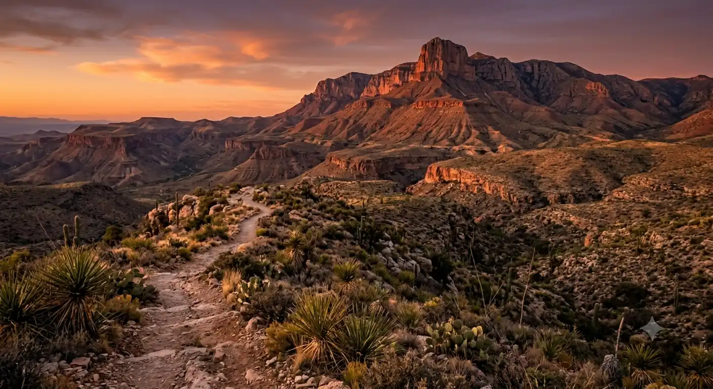
El CapitanThe summit aheadAscend to Guadalupe Peak Campground · 3.1 miles
El Capitan belowHigh country aheadLeave Pine Springs on the Guadalupe Peak Trail and climb hard, roughly 2,000 ft of gain over 3 steep, switchbacking miles to the high Guadalupe Peak Campground. The trail is fully exposed to sun and wind, but the views open up fast over El Capitan and the Chihuahuan Desert far below.
The campground has just a handful of primitive sites and a vault toilet, no water. Set up early, shelter from the wind, and rest: tomorrow you make the short pre-dawn push to the summit of Texas.
- ~3.1 mi · ~2,000 ft gain · Strenuous · exposed
- El Capitan viewpointThe park's signature 8,085-ft limestone cliff
- Guadalupe Peak Campground~8,000 ft · primitive sites · vault toilet · no water
- The Guadalupe Peak Trail is fully exposed. Start early, wear sun protection, and carry all your water for the climb, there is none on the trail.
- Wind on the upper mountain can be fierce. Pitch a wind-resistant 3-season tent and stake out well at the Guadalupe Peak Campground.
- Trekking poles help a lot on the steep, rocky switchbacks in both directions.
Summit Guadalupe Peak, Descend to Tejas · 8.4 miles
Make the short final push to the summit of Guadalupe Peak (8,751 ft), the highest point in Texas, marked by its stainless-steel pyramid monument. The 360-degree panorama sweeps across the desert, El Capitan, and the salt flats far below, and the wind up top can be ferocious.
Back at camp, shoulder your pack and follow the Tejas Trail north, trading exposed ridges for the cooler pine-and-fir forest of the high country. Camp at Tejas Campground, a sheltered basin site that is a hub for the park's high-country trails.
- Highest point in Texas · steel pyramid monument · 360° views
- ~7.3 mi · descend into shaded pine and fir
- Tejas Campground~7,500 ft · 10 sites · sheltered basin · no water
- Summit early. The pyramid monument marks the true top, and the wind builds through the day, so catch the calm and the views before mid-morning.
- Tejas Campground sits in a forested basin and offers far more wind shelter than the exposed Guadalupe Peak Campground.
- Watch for mule deer and other wildlife as you drop into the shaded high country. Store food properly at every camp.
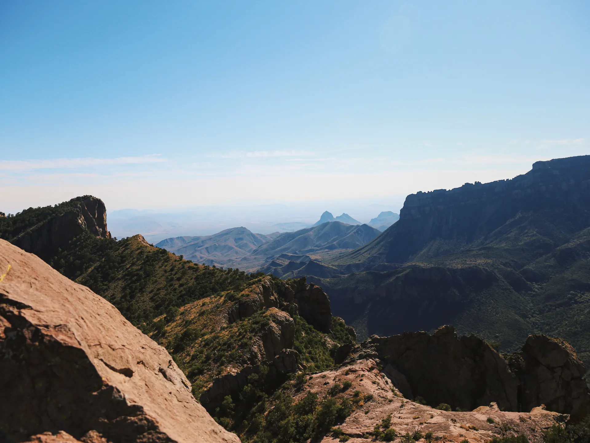
Tejas high countryToward McKittrickCross to McKittrick Ridge · 8.0 miles
High traverseRidge climbFrom Tejas, traverse the high country and drop toward the head of McKittrick Canyon, one of the most beautiful corners of the park, where a spring-fed stream supports maples, oaks, and a rare desert riparian forest that blazes with color in late fall.
Climb the final steep pitch out to McKittrick Ridge Campground, an exposed, remote perch with long views toward New Mexico. It is a demanding day with real elevation change, so pace your water and your energy.
- ~5 mi · varied terrain · into the canyon system
- Climb to McKittrick Ridge Campground~3 mi · steep · exposed ridge hiking
- McKittrick Ridge Campground~7,000 ft · 4 sites · views toward New Mexico · no water
- This is a long day with meaningful elevation change. Start early and ration water carefully, there is none anywhere on the route.
- McKittrick Ridge is exposed to wind. Choose a sheltered tent spot and stake out for gusts.
- If you time the trip for late October or November, the maples in McKittrick Canyon can be in peak fall color, a rare sight in West Texas.
Descend to McKittrick Canyon Trailhead · 7.6 miles
Your final day is a long, ~2,500-ft descent from McKittrick Ridge down through the canyon to the McKittrick Canyon Trailhead. The lower sections pass the historic Pratt Cabin and the Grotto and can be hot and exposed, so start early and savor the stream and the shade.
This trailhead is separate from Pine Springs, so arrange a shuttle or a spotted car in advance, it is about a 20-minute drive back to the visitor center. Note the McKittrick day-use gate hours (roughly 8 AM to sunset) so you are not locked in or out.
- ~7.6 mi · ~2,500 ft descent · Pratt Cabin & the Grotto
- Day-use gate ~8 AM–sunset · shuttle or spotted car needed
- The McKittrick Canyon trailhead is not Pine Springs. Spot a car or arrange a shuttle before your trip, there are no services and no cell signal to call one.
- The McKittrick day-use area gate closes around sunset. Check current hours at the visitor center so you can drive out.
- The lower canyon can be hot even in cool months. Start the descent early and keep a little water in reserve for the exposed final miles.
The drive outTrip completeNow build your Guadalupe Mountains trip.
You've seen all five days. Open the free drag-and-drop planner and tune it for your dates, your fitness, your water caches, and which of the park's ten wilderness campgrounds you can reserve.
Essential wilderness regulations & planning.
Wilderness permit is mandatory
Every overnight in the backcountry needs a wilderness use permit: $6 reservation plus $6 per person per night. Reserve on recreation.gov up to three months ahead, then pick the permit up in person at the Pine Springs Visitor Center by 3:30 PM Mountain, up to 48 hours before your trip. Walk-up permits for unreserved sites are issued 8 AM to noon daily. Maximum 10 people per permit.
Carry every drop of water
There are no reliable water sources anywhere in the Guadalupe backcountry. Plan for 4-6 liters of capacity per person per day, and cache water in advance with park permission if you can. This is the single biggest planning constraint on the trip.
No fires · pack it all out
Backcountry fires are prohibited, cook on a stove. Bear canisters are not required, but hang a bear bag to protect food from wildlife. Pack out all trash and all human waste (WAG bags), and follow Leave No Trace strictly.
Go October through April
The season is October to April, when temperatures are mild. Summer (May-September) brings 100°F+ heat and dangerous monsoon storms. Spring can be extremely windy; fall (October-November) is the sweet spot, with pleasant temperatures and fall color in McKittrick Canyon.
Getting there needs a car
El Paso International Airport (ELP) is the nearest airport, about 2 hours and 110 miles from the Pine Springs Visitor Center. Nearest lodging and services are in Van Horn, TX (~1 hr) and Carlsbad / Whites City, NM (~45 min). No public transportation reaches the park, so a car is required.
Two separate trailheads
This traverse starts at Pine Springs and ends at the McKittrick Canyon Trailhead, about a 20-minute drive apart. Spot a car or arrange a shuttle before you start, and note that the McKittrick day-use gate closes around sunset.
Everything you'll actually want to know.
Ready to go? Get your
Guadalupe Mountains route.
Trailheads and mileages, the wilderness-permit and water-cache logistics, the two-trailhead shuttle, drive times from El Paso, and the summit timing you need to bag the highest point in Texas and traverse to McKittrick Canyon.
Instant book · Free cancellation · Secure payment via Stripe


Planning this trip?
Save it, share it with your crew, or find travelers heading the same way.

Liked this itinerary?
What other travelers are saying
Be the first to leave a tip or question for the next traveler.