Georgia Appalachian Trail Map +
7-Day Springer to Bly Gap Itinerary
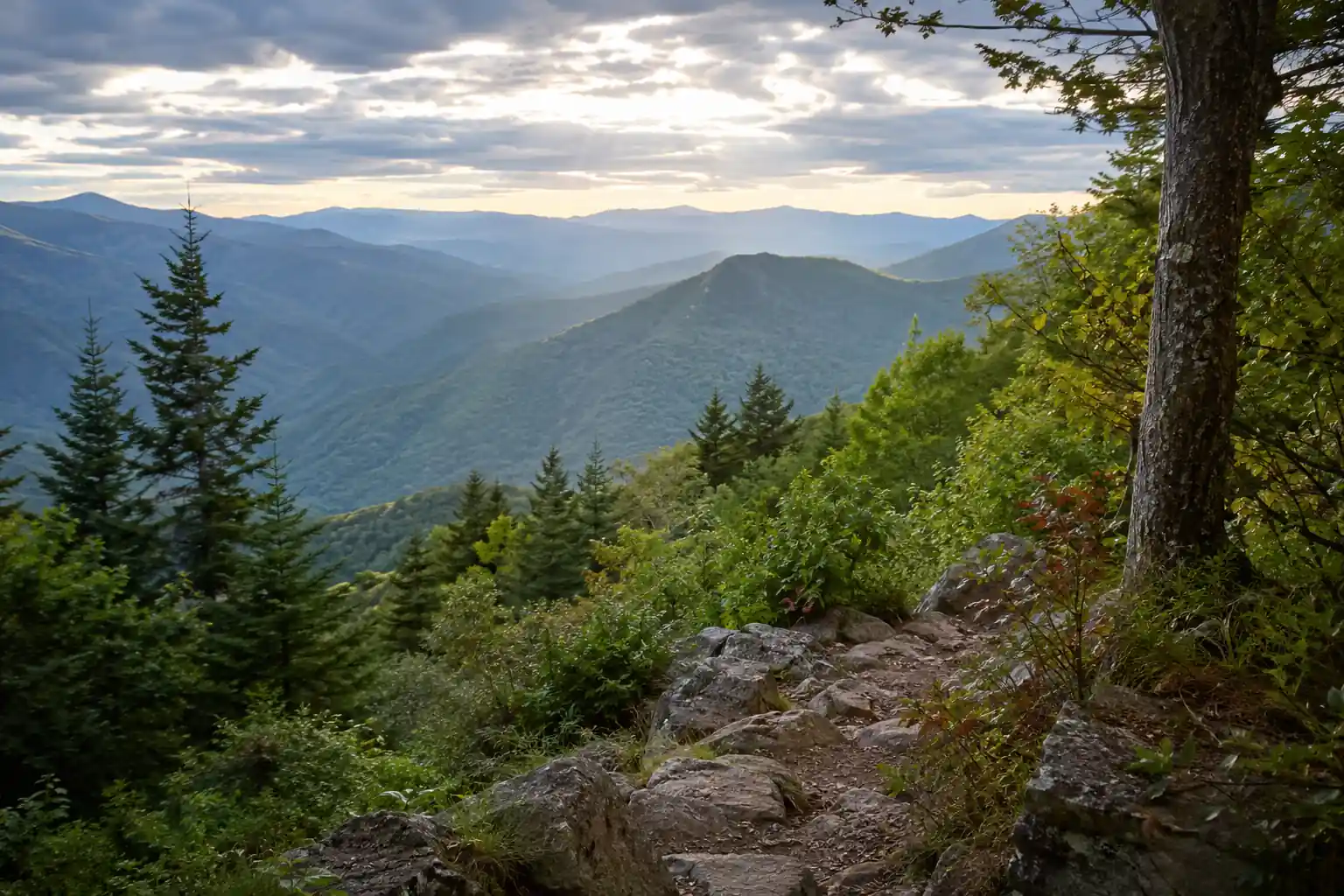
7-day Georgia Appalachian Trail section hike. The first 78 miles of the AT from the southern terminus on Springer Mountain, over Blood Mountain (4,458 ft), past the Neels Gap outfitter, to Bly Gap on the North Carolina line, where every thru-hiker's journey begins.
Free interactive planner · drag & reorder your days, add stops, map it in minutes
Build your own Georgia AT trip, drag, reorder & map it.
Drag stops between days, adjust your mileage, and add your own shelters, gaps, and road crossings with the place search. The live map and trail legs recalculate as you go, so you can tune the Springer-to-Bly-Gap section to your pace and shuttle plan before you head into the Chattahoochee National Forest.
Opens a side panel · reorder days, add custom stops, see your route live
The first 78 miles of the Appalachian Trail, from Springer to Bly Gap.
This 7-day section hike covers the Georgia Appalachian Trail from its southern terminus on Springer Mountain to Bly Gap on the North Carolina border, the 78 miles where every northbound thru-hiker begins. Base your logistics out of Amicalola Falls State Park for the approach, and use Hiawassee or Blairsville for resupply and post-hike lodging.
Expect demanding days of 10 to 14 miles with significant elevation change over landmarks like Blood Mountain (4,458 ft), the highest point on the AT in Georgia, and the on-trail outfitter at Neels Gap. The route is well-marked with white blazes, but this is strenuous backpacking that rewards good conditioning and multi-day experience.
No permits are required to hike or camp on the AT in Georgia, but Leave No Trace is mandatory: camp only at designated or established sites, treat all water, and store food in a bear canister or a properly hung bear bag. March through May brings spring blooms and thru-hiker energy; September through November brings fall foliage and fewer bugs.
Book your shuttle 2 to 4 weeks ahead, especially in the March-April thru-hiker rush and October foliage weekends. Parking at Amicalola Falls State Park is $5 per day or $55 for a Georgia State Parks annual pass. Blood Mountain Cabins near Neels Gap need reservations, and hostels or lodges in Dahlonega, Blairsville, and Hiawassee fill fast in peak season.
Approach Trail & Springer Mountain · 11.8 miles
Start early from Amicalola Falls State Park, check in, pay the parking fee, and confirm your return shuttle. The 8.8-mile approach trail climbs the 604 steps beside Amicalola Falls and gains serious elevation before it delivers you to Springer Mountain, so treat the whole day as a warm-up with a full pack.
At the Springer Mountain (3,782 ft) summit, touch the bronze plaque, sign the thru-hiker register, and start counting white blazes north. Continue three miles past the terminus to Stover Creek Shelter, the first shelter on the AT northbound, to pitch camp and secure your food for the night.
- Start point · $5 daily parking · shuttle pickup
- 8.8 mi · ~2,000 ft gain · blue-blaze · strenuous
- 3,782 ft · sign the register · first white blaze
- Stover Creek Shelter3 mi past Springer · shelter + tent sites · privy
- Start early from Amicalola Falls, the 8.8-mile approach trail plus miles past Springer make this a long first day with a full pack.
- Pay the $5 daily parking fee or buy the $55 Georgia State Parks annual pass, and confirm your return shuttle before you leave the visitor center.
- Stover Creek Shelter, three miles past Springer, is the first shelter northbound and a common first-night stop, so arrive with daylight to claim a tent site.
Springer MountainStover Creek ShelterSpringer Mountain to Gooch Mountain Shelter · 14.2 miles
Long Creek FallsGooch Mountain ShelterDepart Stover Creek and settle into your trail rhythm on a classic Georgia AT day of rolling hills and steady climbs through dense forest. Cross several small streams, pass through Horse Gap, and refill water at Hawk Mountain Shelter before the trail descends toward Gooch Gap.
Watch for the short side trail to Long Creek Falls, then climb to Gooch Mountain Shelter, a spacious and popular first-night stop for thru-hikers with established tent pads and a reliable spring. Fourteen miles is a big day, so pace your water and snacks.
- Hawk Mountain Shelter~5.6 mi · spring nearby · water refill and break
- Long Creek Falls side trail~0.3 mi round trip off the AT · worth the detour
- Gooch Mountain ShelterPopular first-night stop · tent pads · reliable spring
- This is a big-mileage day, so start at first light and pace your water between Hawk Mountain Shelter and the Gooch Gap area.
- The 0.3-mile round-trip spur to Long Creek Falls is one of the prettiest quick detours in Georgia, take it if your legs allow.
- Gooch Mountain Shelter is spacious with good tenting, but it is a popular thru-hiker stop in spring, so have a backup site in mind.
Gooch Mountain to Blood Mountain & Neels Gap · 14.6 miles
Climb out of Gooch Mountain and descend to Woody Gap, a popular day-hiker access point on GA 60, then begin the steady ascent over Big Cedar Mountain toward the day's big objective. The summit of Blood Mountain (4,458 ft) is the highest point on the AT in Georgia, crowned by a historic CCC stone shelter and panoramic views.
Descend the steep, rocky 1.8 miles to Neels Gap, where the trail literally passes through Mountain Crossings at Walasi-Yi, the only on-trail outfitter and a critical resupply, gear-repair, and snack stop. Continue a short way to Blood Mountain Cabins (reserve ahead) or a dispersed site.
- Day-hiker access · Big Cedar Mountain views ahead
- Highest AT point in GA · historic stone shelter
- Only on-trail outfitter · resupply, gear, food, water
- ~2.8 mi past Neels Gap · cabins or dispersed camping
- The 1.8-mile descent from Blood Mountain to Neels Gap is very rocky and steep, so save knee strength and take your time.
- Mountain Crossings at Neels Gap is the only outfitter directly on the trail, use it for resupply, a hot snack, gear fixes, or a famous pack shakedown.
- The historic stone shelter on Blood Mountain's summit is for emergency day use, not planned overnights, so aim to camp past Neels Gap.
Neels Gap · Mountain CrossingsBlood Mountain shelterNeels Gap to Low Gap Shelter · 11.2 miles
Hogpen GapLow Gap ShelterAfter the punishing Blood Mountain day, this stretch is slightly gentler but still demanding, climbing out of the Neels Gap valley over rolling terrain and several small gaps. Pass through Tesnatee Gap and cross the road at Hogpen Gap before the trail winds through deep forest toward camp.
Continue the steady climb to Low Gap Shelter, a well-maintained standard AT shelter with space for tenting, a privy, and a reliable water source nearby. Hang your food or store it in a canister for the night.
- Tesnatee & Hogpen Gap crossingsRolling terrain · road crossing at Hogpen Gap · no services
- Low Gap ShelterStandard AT shelter · privy · tent sites · good water
- This day is easier than Blood Mountain but still climbs steadily, so keep an even pace out of the Neels Gap valley.
- Hogpen Gap is a road crossing with no services, treat it as a checkpoint rather than a resupply.
- Low Gap Shelter has a reliable water source and multiple tent sites, making it a comfortable and popular overnight.
Low Gap Shelter to Tray Mountain Shelter · 10.9 miles
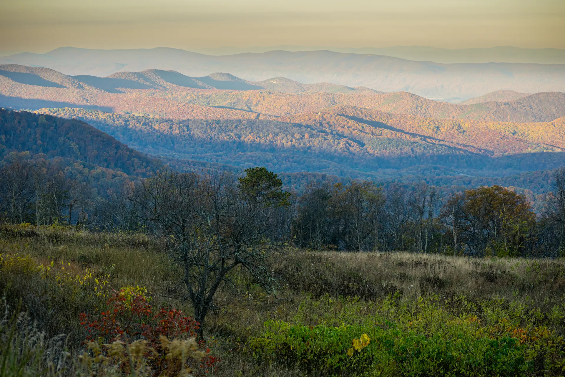
Begin with a challenging climb out of Low Gap toward Blue Mountain, which delivers some of the best long-range views in Georgia. Descend the steep switchbacks to Unicoi Gap, a major crossing on GA 75 and another possible shuttle or resupply point if arranged in advance.
From Unicoi Gap, tackle the significant climb to Tray Mountain, one of the more exposed sections in Georgia. Tray Mountain Shelter sits just below the summit with excellent sunrise and sunset views and a spring nearby, though the open ridge can be windy.
- Blue Mountain~4.1 mi · significant climb · panoramic ridge views
- Unicoi Gap (GA 75 crossing)Major road crossing · possible shuttle/resupply point
- Just below the summit · big views · spring nearby
- Blue Mountain has some of the best long-range views in Georgia, so time a snack break for the summit ridge on a clear day.
- Unicoi Gap on GA 75 is a logical bail-out or resupply point if you pre-arrange a shuttle, since there are no services at the gap itself.
- Tray Mountain Shelter's exposed setting means great sunrise and sunset views but real wind, so stake out well and layer up at night.
Blue MountainUnicoi GapTray Mountain to Plumorchard Gap · 12.3 miles
Dicks Creek GapPlumorchard GapDescend from Tray Mountain into a rhythm of climbs and drops, including the ascent of Kelly Knob and the scenic Swag of the Blue Ridge, through deep forest and small stream crossings. Continue down to Dicks Creek Gap on US 76, a popular road crossing and a classic spot for trail magic.
Climb again toward Plumorchard Gap, where a short side trail leads to the shelter and several dispersed camping options. This is your last night on the Georgia AT, so enjoy the deep-forest quiet before the final push to the state line.
- Kelly Knob & Swag of the Blue RidgeSeries of climbs and descents · forest and stream crossings
- Dicks Creek Gap (US 76 crossing)Popular road crossing · classic trail-magic spot
- Plumorchard Gap Shelter & dispersed sitesShort side trail to shelter · established backcountry sites
- The Kelly Knob climb is the sting in this day, so keep energy in reserve for the ups and downs after Tray Mountain.
- Dicks Creek Gap on US 76 is a well-known trail-magic and shuttle spot, a good place to top off water and morale.
- Camp at established sites near Plumorchard Gap and practice strict Leave No Trace, since some water sources here can be seasonal.
Plumorchard Gap to Bly Gap · 7.8 miles
A shorter final day of rolling terrain and a few last climbs, passing through Deep Gap with final views back over the Georgia mountains. The trail stays rocky in sections before you reach the state line.
Arrive at Bly Gap, marked by a sign and the famous gnarled Bly Gap Tree, the symbolic end of your Georgia section hike and the gateway into North Carolina. Meet your pre-arranged shuttle here or at a nearby road crossing for the ride back to Amicalola Falls or a town like Hiawassee.
- Plumorchard Gap to Bly Gap7.8 mi · Deep Gap · rolling terrain · final GA views
- Bly Gap & the Bly Gap TreeGA/NC state line · iconic gnarled oak · photo op
- Shuttle from Bly GapPre-booked pickup · return to Amicalola or Hiawassee
- This is a shorter day, which makes shuttle coordination easier, aim for an early-afternoon finish at Bly Gap.
- Bly Gap is marked by a sign and the famous gnarled Bly Gap Tree, the classic finish-line photo of a Georgia section hike.
- There are no services at Bly Gap, so confirm your pickup location and time before you lose cell service on the final ridge.
Deep Gap viewsInto North CarolinaNow build your Georgia AT trip.
You've seen all seven days. Open the free drag-and-drop planner and tune it for your dates, your pace, and how many miles a day you actually want to hike between shelters.
Essential backpacking rules & planning.
Store your food properly
Bear canisters are not strictly required on the Georgia AT but are highly recommended, and a properly hung bear bag is the accepted alternative. Camp only in designated shelters or established backcountry sites, and never leave food or scented items in your tent.
Leave No Trace is mandatory
Pack out all trash, including food scraps, and camp only at designated or established sites. Fires are often restricted to existing fire rings, so check current fire restrictions for the Chattahoochee National Forest before you go.
The approach trail adds 8.8 miles
The approach trail from Amicalola Falls to Springer Mountain is an extra 8.8 miles with real elevation gain, including the 604 steps past the falls. Factor it into your Day 1 mileage and start early with a full pack.
Resupply at Neels Gap
Mountain Crossings at Neels Gap on Day 3 is the only outfitter directly on the trail and your main resupply point, with food, gear, and mail-drop service. For a full resupply, shuttle into Blairsville or Hiawassee.
Book shuttles 2 to 4 weeks ahead
Shuttle services run roughly $100 to $300 depending on distance and group size, and they book out fast in the March-April thru-hiker rush and October foliage weekends. Parking at Amicalola Falls is $5 per day or $55 for a state-parks annual pass.
Go in spring or fall
March through May brings cooler temps, wildflowers, and thru-hiker energy but also rain, cold snaps, and crowded shelters. September through November brings fall foliage, fewer bugs, and stable weather. Summers are hot, humid, and buggy; winters are cold with snow and ice.
Everything you'll actually want to know.
Ready to go? Get your
Georgia Appalachian Trail route.
Trailheads and mileages from Springer to Bly Gap, the shelter and dispersed-camping options, the Neels Gap resupply, Amicalola parking, shuttle timing, and the daily mileage you need to finish the first 78 miles of the AT in a week.
Instant book · Free cancellation · Secure payment via Stripe


Planning this trip?
Save it, share it with your crew, or find travelers heading the same way.

Liked this itinerary?
What other travelers are saying
Be the first to leave a tip or question for the next traveler.