
Georgia Outdoor Circuit Map +
10-Day Adventure Itinerary
10-day Georgia outdoor circuit connecting the state's wildest landscapes: an Appalachian Trail backpack from Springer Mountain, Class III-IV whitewater on the Chattooga, an overnight kayak into the Okefenokee Swamp, and barrier-island camping on Cumberland Island.
Free interactive planner · drag & reorder your days, add stops, map it in minutes
Build your own Georgia circuit, drag, reorder & map it.
Drag stops between days, swap segments, and add your own trailheads, outfitters, and towns with the place search. The live map and drive legs recalculate as you go, so you can tune this mountains-to-coast circuit to your pace and permit windows before you commit.
Opens a side panel · reorder days, add custom stops, see your route live
Mountains, rivers, swamp & barrier island, in one loop.
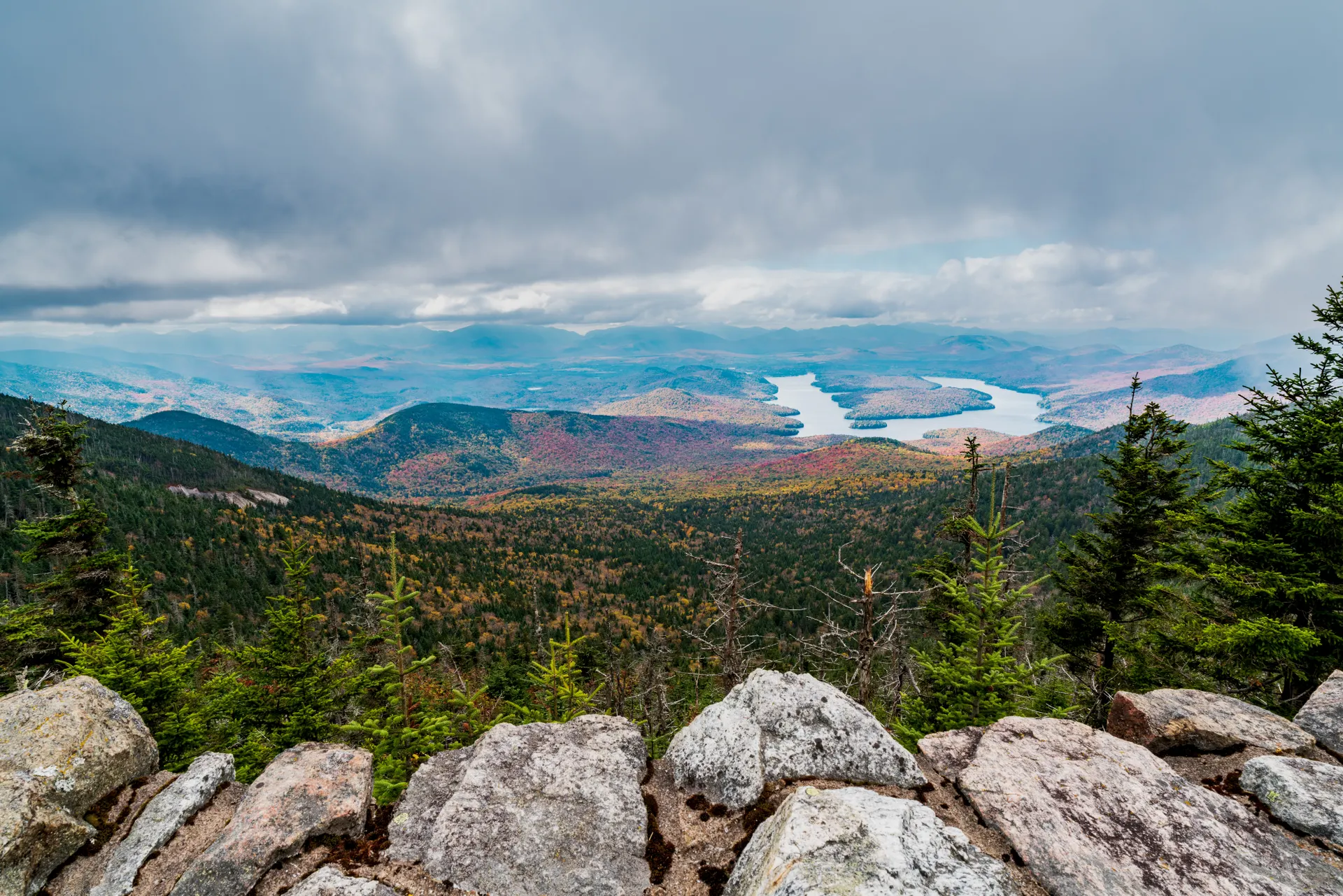
This 10-day Georgia outdoor circuit runs the full length of the state, from the Southern Appalachians in the north to the wild Atlantic barrier islands in the south. It strings together four completely different ecosystems and four different sports: backpacking, whitewater rafting, kayaking, and wildlife viewing.
You start with a three-day Appalachian Trail section hike from Springer Mountain, the AT's southern terminus, then raft Class III-IV rapids on the Wild & Scenic Chattooga River. After a long drive south you paddle an overnight Okefenokee Swamp wilderness trip, and finish camping wild on Cumberland Island among its famous feral horses.
Base towns are Clayton, Helen, Folkston, and St. Marys. Permits are required for the Okefenokee overnight paddle and Cumberland Island backcountry camping, and both book out months ahead. Aim for April–May or September–October for the best weather, fewest bugs, and safest whitewater levels.
Okefenokee overnight wilderness canoe-trail permits and Cumberland Island backcountry permits are limited and can book out 4–6 months ahead, especially for spring and fall. Reserve Okefenokee permits through recreation.gov and Cumberland Island ferry tickets and camping through the National Park Service. Book the Chattooga Section IV guided raft trip 1–2 months out, and lodging in Helen and St. Marys at least 2–3 months ahead.
Arrive in North Georgia & Prep for Backpacking
Fly into Hartsfield-Jackson Atlanta International Airport (ATL) and drive north to Clayton, a gateway town to the Southern Appalachians. Use the afternoon to gather last-minute supplies, check the weather, and pack for tomorrow's Appalachian Trail backpack.
Clayton has grocery stores and outdoor shops for anything you forgot, and sits close to Tallulah Gorge and Black Rock Mountain State Parks if you have extra time. Overnight in Clayton or a nearby cabin so you're well rested for an early start on the trail.
- Drive from ATL to Clayton, GA~90 mi · 1.5–2 hr · mountain gateway town
- Resupply & pack in ClaytonGrocery stores and outdoor shops for last-minute gear
- Overnight in Clayton, GAHotels, cabins, and B&Bs · book ahead in peak season
- Confirm your Springer Mountain shuttle or a pre-positioned vehicle at Woody Gap before you start, since this is a point-to-point section hike.
- Buy fuel and any last groceries in Clayton, as trail-town resupply options thin out fast once you leave.
- Cabin rentals around Clayton book out in peak spring and fall, so reserve your first night early.
AT countryPack & prepAppalachian Trail: Springer Mountain to Hawk Mountain Shelter · 8.1 mi
Follow the white blazesHawk Mountain ShelterDrive to the Springer Mountain parking area on Forest Service Road 42, then hike the approach trail to the AT's official southern terminus (3,782 ft). Sign the register at the bronze plaque, then begin your northbound journey. The day is moderately strenuous with several climbs and descents through classic Southern Appalachian forest.
Your goal is Hawk Mountain Shelter, a well-maintained backcountry shelter with tent sites and a nearby water source. It's first-come, first-served, so have a tent as backup. Filter all water, hang a bear bag or use a canister, and settle in for your first night on the trail.
- 3,782 ft · AT southern terminus · sign the register
- Backpack to Hawk Mountain Shelter8.1 mi · ~1,500 ft gain · moderate to strenuous
- Overnight at Hawk Mountain ShelterFirst-come shelter · tent sites · filter the water source
- The road to the Springer Mountain trailhead is gravel and can be rough, so check conditions and leave no valuables in your car.
- Shelters here are first-come, first-served, so carry a tent and be ready to pitch it if the shelter is full.
- A bear bag or canister is required for food storage on this stretch of the AT. Hang or stow everything scented.
Appalachian Trail: Hawk Mountain to Gooch Mountain Shelter · 7.6 mi
Continue your northbound trek across rolling terrain through dense forest, with occasional views through the trees and several small stream crossings. You may share the trail with other thru-hikers and section hikers this time of year.
Aim for Gooch Mountain Shelter, another established backcountry site with tent space and water. Set up camp, rehydrate, and practice strict Leave No Trace. Monitor the forecast, as North Georgia afternoons can turn to rain quickly.
- Backpack to Gooch Mountain Shelter7.6 mi · ~1,200 ft gain · rolling forested terrain
- Overnight at Gooch Mountain ShelterFirst-come shelter · tent sites · reliable water source
- Practice Leave No TraceBear-safe food storage · pack out all trash
- Keep an eye out for white blazes at junctions, since side trails and forest roads can pull you off the AT.
- Top off water at the shelter source and filter it, as reliable water can be spaced out on this section.
- Pack rain gear within reach. Afternoon storms build fast over the North Georgia ridgeline.
Gooch Mountain ShelterStream crossingsGooch Mountain to Woody Gap & Drive to Helen · 6.5 mi + drive
Woody Gap viewsTrail's endComplete the final leg of your section hike, descending toward Woody Gap with glimpses of long-range mountain views along the way. Retrieve your pre-positioned vehicle or meet your shuttle at the gap, which is a popular day-hiker access point on GA Highway 60.
Then drive to the Bavarian-themed town of Helen for a complete change of pace. Check in, clean up, and enjoy a hearty meal. Tonight is for rest and resupply before tomorrow's whitewater day on the Chattooga.
- Backpack to Woody Gap6.5 mi · ~900 ft gain · rewarding descent to GA-60
- Drive from Woody Gap to Helen, GA~20 mi · ~45 min · Bavarian-themed town
- Overnight in Helen, GAHotels, cabins, and resorts · wide range of options
- Woody Gap is a busy day-hike trailhead, so a pre-arranged shuttle or a car left here is the simplest way to end the backpack.
- Helen fills up on weekends and during Oktoberfest, so book your room ahead and expect heavy traffic on Main Street.
- Use tonight to dry gear and swap your backpacking kit for quick-dry clothes and secure footwear for the river.
Whitewater Rafting on the Chattooga River · Section IV
Spend the day rafting the Wild & Scenic Chattooga River, which forms part of the Georgia–South Carolina border. Section IV is renowned for challenging Class III-IV rapids, including the famous Five Falls sequence of Entrance, Corkscrew, Crack-in-the-Rock, Jawbone, and Sock 'em Dog.
Because private boating on Section IV requires significant skill and specific permits, book a guided trip with an outfitter near Long Creek, SC or Clayton, GA. They provide all gear, instruction, and shuttle to and from the river. Expect a full 6–8 hours on the water in a remote wilderness setting, then return to Helen for the night.
- Drive to the Chattooga River outfitter~1 hr from Helen · near Long Creek, SC or Clayton, GA
- Guided rafting · Chattooga Section IVClass III-IV · 6–8 hr · the Five Falls · age limits apply
- Overnight in Helen, GALast night in North Georgia · relax and recover
- Section IV must be run with a licensed outfitter, so book your guided trip 1–2 months ahead and arrive at least 30 minutes early.
- Wear quick-dry clothes and secure footwear such as water shoes or old sneakers. Outfitters supply the raft, paddle, PFD, and helmet.
- Water levels drive the experience. Spring generally brings the fullest, most exciting flows, while late summer can run lower.
Class III-IVBack to HelenDrive South & Okefenokee Swamp Exploration · ~250 mi
Gators & birdsFolkston baseMake the long drive south, trading the mountains for the coastal plain and the vast Okefenokee Swamp. Your destination is Folkston, the gateway to the refuge's eastern entrance at the Suwannee Canal Recreation Area.
On arrival, visit the Richard S. Bolt Visitor Center and the Chesser Island Homestead and boardwalk for a first taste of the swamp. The boardwalk is superb for spotting alligators, wading birds, and turtles. Catch a ranger program if one is offered, then overnight in Folkston.
- Drive from Helen to Folkston, GA~250 mi · 4.5–5 hr · mountains to coastal plain
- Richard S. Bolt Visitor Center · Chesser Island boardwalk
- Overnight in Folkston, GALimited lodging · book ahead · Southern comfort food
- This is the longest drive of the trip, so leave early and plan fuel and meal stops as the landscape flattens toward the coast.
- The refuge charges a small entrance fee per vehicle. Check current rates and hours before you arrive.
- Folkston has only a handful of hotels and B&Bs, so reserve your room well in advance.
Okefenokee Swamp Overnight Kayak Trip · 8–10 mi paddling
Launch on an unforgettable overnight paddle into the heart of the Okefenokee Swamp. This requires an advance wilderness canoe-trail permit, which is competitive and released on a set schedule through recreation.gov. Check in at the visitor center, then follow a designated water trail such as the Suwannee Canal Wilderness Canoe Trail through cypress forest and open prairies dotted with gator holes.
Spend the night on a designated chickee platform, an elevated wooden deck where you pitch your tent above the water. It's a genuinely wild backcountry experience with the sounds of the swamp all around you. Bring your own water, be ready for insects, and store all food securely from raccoons and alligators.
- Overnight canoe-trail permit · book months ahead
- Kayak the Suwannee Canal wilderness trail8–10 mi · 6–8 hr · cypress, prairies & gators
- Overnight on a chickee platformElevated deck · composting toilet · bring your own water
- Overnight wilderness permits are limited and released on a set schedule, so plan to book 4–6 months ahead for spring and fall.
- There is no potable water in the swamp, so carry all the water you need. Filtering black swamp water is a last resort.
- Stay on the marked water trail and give alligators a wide berth. It is easy to get disoriented in the open prairies.
Chickee campGator countryOkefenokee Morning Paddle & Drive to St. Marys · ~50 mi
Morning paddleCoastal St. MarysWake to the sounds of the swamp and enjoy a final morning paddle back toward your put-in. Early hours are prime for wildlife, when herons, egrets, and cranes are most active and the water is glassy and still. Take your time soaking in the serene atmosphere.
After packing up, drive east to St. Marys, the charming coastal town that serves as the ferry departure point for Cumberland Island National Seashore. Grab any last supplies for the island, confirm tomorrow's ferry time, and overnight in town.
- Morning paddle out of the Okefenokee4–6 mi · 2–3 hr · prime early-morning wildlife
- Drive from Folkston to St. Marys, GA~50 mi · ~1 hr · gateway to Cumberland Island
- Overnight in St. Marys, GAHistoric coastal town · last resupply before the island
- Paddle out early. Cooler morning hours are the best time to see wading birds and other swamp wildlife.
- St. Marys is your last chance to buy groceries and fuel before Cumberland Island, which has no stores.
- Reconfirm your Cumberland Island ferry departure time tonight, since the schedule is strict and you cannot drive on.
Cumberland Island: Sea Camp to Stafford Beach · 5 mi
Catch the early ferry from St. Marys to Cumberland Island National Seashore, a 45-minute ride across Cumberland Sound with a chance to spot dolphins. At Sea Camp Dock, check in with rangers and confirm your backcountry permit.
Hike about 5 miles north to Stafford Beach, choosing the pristine beach or the interior Parallel Trail through maritime forest. Watch for the island's famous wild horses along the way. Stafford Beach is a primitive campground with cold-water showers and composting toilets, steps from an undeveloped Atlantic shore.
- ~45 min · book ahead · no vehicles on the island
- Hike Sea Camp to Stafford Beach5 mi · flat · beach or maritime-forest trail
- Overnight at Stafford Beach CampgroundPrimitive sites · cold showers · composting toilets
- Ferry tickets and backcountry permits are highly competitive, so book both roughly six months ahead for peak season.
- There is no potable water on the trail, so carry everything you need and treat any water you collect on the island.
- The wild horses are feral, not tame. Observe them from a distance and never approach or feed them.
Empty coastlineMaritime forestCumberland Island Exploration & Departure
One last beach walkFerry homeWake to the ocean and enjoy a final morning on the island. Hike south to the historic Dungeness Ruins, the shell of a Carnegie mansion where horses often graze, or simply stroll the beach hunting shells and watching wildlife. Allow plenty of time to return to Sea Camp for your ferry.
Catch the afternoon ferry back to St. Marys, then drive to Jacksonville International Airport (JAX), about an hour away, for the closest flights home, or make the longer drive back to Atlanta (ATL) to close the loop on your Georgia outdoor circuit.
- Explore the Dungeness Ruins & beachHistoric Carnegie mansion site · shells & wildlife
- Afternoon ferry back to St. Marys~45 min · arrive at the dock early · strict schedule
- Drive to JAX or ATL to fly homeJAX ~1 hr · ATL ~5 hr · end of the circuit
- The ferry schedule is strict and there is no other way off the island, so budget extra time to walk back to Sea Camp.
- Jacksonville (JAX) is the closest airport at about an hour away. The drive back to Atlanta is roughly five hours.
- Pack out every scrap of trash. Leave No Trace is critical on this protected barrier island.
Now build your Georgia circuit.
You've seen all ten days. Open the free drag-and-drop planner and tune it for your dates, your pace, and which permits you can actually land for the Okefenokee and Cumberland Island.
Essential permits, timing & planning.
Lock in permits early
The two hardest reservations are the Okefenokee overnight wilderness canoe-trail permit (via recreation.gov) and the Cumberland Island backcountry permit plus ferry (via the National Park Service). Both are limited and can book out 4–6 months ahead for spring and fall. Section hikers on the AT generally do not need a permit for the shelters on this stretch.
Go in spring or fall
April–May brings mountain wildflowers, active swamp wildlife, and good whitewater levels, with humidity climbing toward late May. September–October brings cooler temperatures, fall foliage in the Appalachians, and fewer bugs on the coast. Avoid June–August heat, humidity, and insects, and watch hurricane forecasts in fall.
Plan the point-to-point logistics
The AT section is point-to-point, so arrange a shuttle or a pre-positioned car at Woody Gap before you start at Springer Mountain. The drive from the mountains to the Okefenokee is roughly 4.5–5 hours, so treat Day 6 as a travel day and don't over-schedule it.
Bring your own gear, rent the rest
You supply personal backpacking gear for the AT, Okefenokee, and Cumberland Island. Whitewater outfitters provide all technical rafting gear. Kayaks and canoes for the Okefenokee can be rented from outfitters near the refuge entrances if you don't bring your own.
Store food & respect wildlife
Use a bear bag or canister on the AT, secure all food from raccoons and alligators on the Okefenokee chickees, and keep your distance from Cumberland Island's feral horses. Never approach or feed any wildlife on the circuit.
Expect no cell service in the backcountry
Towns like Clayton, Helen, Folkston, and St. Marys have reliable service, but expect little to none on the AT backcountry, deep in the Okefenokee, and on Cumberland Island. Carry a satellite communicator for emergencies in the remote segments.
Everything you'll actually want to know.
Ready to go? Get your
Georgia outdoor circuit route.
The permit windows, trail mileages, drive times, ferry logistics, and outfitter bookings you need to link the Appalachian Trail, the Chattooga, the Okefenokee, and Cumberland Island into one 10-day loop.
Instant book · Free cancellation · Secure payment via Stripe


Planning this trip?
Save it, share it with your crew, or find travelers heading the same way.

Liked this itinerary?
What other travelers are saying
Be the first to leave a tip or question for the next traveler.