Eastern Sierra 10-Day Loop Map +
Mammoth Lakes Backpacking Itinerary
10-day Eastern Sierra itinerary based in Mammoth Lakes: a 3-day Minaret Lake backpacking trip in the Ansel Adams Wilderness, then Devils Postpile, Rainbow Falls, Mono Lake tufa towers, the June Lake Loop, Convict Lake, and the Mammoth Crest, all from one base town.
Free interactive planner · drag & reorder your days, add stops, map it in minutes
Build your own Eastern Sierra trip, drag, reorder & map it.
Drag stops between days, swap the backpacking leg for more day hikes, and add your own trailheads with the place search. The live map and drive legs recalculate as you go, so you can tune this 10-day Mammoth Lakes loop to your pace before you leave cell service behind.
Opens a side panel · reorder days, add custom stops, see your route live
One base town, ten days of High Sierra, from Mammoth Lakes.
This 10-day Eastern Sierra itinerary uses Mammoth Lakes (elevation 7,880 ft) as a single base for the whole trip, so you unpack once and minimize driving. The centerpiece is a 3-day backpacking trip to Minaret Lake below the Minarets, bracketed by relaxed day trips to the region's iconic landmarks.
From the same base you'll hit Devils Postpile National Monument and Rainbow Falls, the Mono Lake tufa towers, the 16-mile June Lake Loop, glacier-carved Convict Lake, and the high, exposed Mammoth Crest reached by the summit gondola.
Overnight wilderness permits are required for the backpacking leg and are quota-controlled through Recreation.gov; a bear canister is mandatory. July through September is the sweet spot, once the high passes clear of snow. Acclimatize slowly, as most trailheads sit above 7,000 ft and the crest tops 10,000 ft.
Overnight wilderness permits for popular Eastern Sierra trailheads sell out fast and open on Recreation.gov roughly six months ahead, so a July trip means booking in January. During peak season (mid-June to early September) private vehicles are barred from Reds Meadow Road between 7 AM and 7 PM, so plan around the mandatory shuttle from the Mammoth Mountain Adventure Center. Book Mammoth Lakes lodging early for summer weekends.
Arrive in Mammoth Lakes & Town Prep
Arrive in Mammoth Lakes, check into the lodging that will be your base for all nine nights, and use the afternoon to finalize supplies and permits. The town (elevation 7,880 ft) has full-service gear shops, groceries, and bear-canister rentals, so this is the day to sort out everything for the backpacking leg.
Confirm your Inyo National Forest wilderness permit, rent a bear canister if you don't own one, and grab last-minute fuel and food. Start acclimatizing tonight, as the trailheads and passes ahead are much higher than town.
- Check into your Mammoth Lakes baseElevation 7,880 ft · hotels, condos & rentals for 9 nights
- Inyo National Forest · canister mandatory for overnights
- Dinner in townLocal breweries and casual dining along Old Mammoth Road
- Confirm your wilderness permit and pick up any physical permit before the ranger station closes.
- Bear canisters are mandatory for all overnight stays in the wilderness and can be rented in town.
- Mammoth Lakes sits at 7,880 ft, so ease into the elevation and hydrate before the backpacking leg.
San Joaquin headwatersToward Minaret LakeBackpack: Reds Meadow to Minaret Lake · 7.5 miles
Reds MeadowThe MinaretsRide the mandatory shuttle from the Mammoth Mountain Adventure Center down into the Reds Meadow Valley, then start your climb into the wilderness. The trail follows the Middle Fork of the San Joaquin River before switchbacking steeply up toward Minaret Lake, about 7.5 miles and 2,400 ft of gain to a basin at roughly 9,800 ft.
Set up camp at the lake below the jagged Minarets, at least 200 ft from water and trails, and stow all food in your bear canister. Expect a cold night at elevation and, in midsummer, the chance of an afternoon thunderstorm.
- Mandatory in peak season · ~20 min from the Adventure Center
- 7.5 mi one-way · 2,400 ft gain · strenuous · lake ~9,800 ft
- Camp at Minaret LakeWilderness site 200+ ft from water · bear canister required
- Take the shuttle from the Adventure Center; private vehicles are barred from Reds Meadow Road 7 AM to 7 PM in peak season.
- Filter or treat all water from the lake and streams, and camp at least 200 ft from water and trails.
- Afternoon thunderstorms are common in July and August, so aim to reach camp by early afternoon.
Backpack: Minaret Lake Layover · 3 miles
Spend a layover day exploring the Minaret Lake basin. Acclimatize, fish, and take a short day hike up to the smaller alpine tarns above the lake for even more dramatic angles on the Minarets. Carrying a light daypack means you can wander without your full load.
This buffer day is also insurance against weather or fatigue and one of the best nights for stargazing on the whole trip, thanks to almost zero light pollution. Keep your camp clean and your food in the canister.
- Day hike to the upper tarns2–3 mi round trip · 500–800 ft gain · moderate
- Fish or relax at the lakeCheck California fishing regulations · high-alpine solitude
- Stargazing from campMinimal light pollution · exceptional night skies
- Use the layover to acclimatize before the descent; the higher tarns are a rewarding, low-mileage day.
- Store all food and scented items in your bear canister overnight, even for a rest day.
- Pack out all trash and human waste, or bury waste in a 6–8 inch cathole 200 ft from water.
Lake campMinaret LakeBackpack: Minaret Lake to Reds Meadow · 7.5 miles
San Joaquin RiverBack in townBreak camp and descend the same trail back to the Reds Meadow Valley, about 7.5 miles and 2,400 ft of loss. The downhill goes quickly, but watch for loose rock on the steeper switchbacks and use trekking poles to save your knees.
At the valley, catch the shuttle back up to Mammoth Lakes and reward yourself with a hot shower, laundry, and a real meal. Resupply tonight for the day-trip half of the itinerary.
- 7.5 mi one-way · 2,400 ft loss · trekking poles help
- ~20 min · last departures ~7 PM (verify schedule)
- Overnight & resupply in townHot shower, laundry, and a celebratory dinner
- Confirm the last shuttle departure time from Reds Meadow before you start down, so you don't get stranded.
- The descent is hard on the knees; trekking poles and a controlled pace make a big difference.
- Resupply food and do laundry tonight so the day-trip days ahead are hassle-free.
Devils Postpile & Rainbow Falls · 5 miles RT
After the backpacking leg, take an easier day exploring Devils Postpile National Monument. Ride the shuttle back into Reds Meadow and walk the short trail to the base of the columns, a striking wall of columnar basalt formed by a lava flow roughly 100,000 years ago. Climb the spur to the top for the tiled, honeycomb view.
Continue downstream about 2.5 miles to Rainbow Falls, a 101-ft drop on the Middle Fork of the San Joaquin that throws rainbows into its mist on sunny afternoons. A shuttle stop near the falls saves you the uphill return if you time it right.
- 0.8 mi round trip · columnar basalt · walk on top
- 2.5 mi one-way from the Postpile · 101-ft waterfall
- Board near the falls or the main Reds Meadow stop
- Time Rainbow Falls for midday to early afternoon, when sunlight is most likely to throw a rainbow in the mist.
- The return from the falls is uphill; use the shuttle stop near the falls to skip the climb.
- An America the Beautiful pass covers the monument entrance; you still pay the separate shuttle fee.
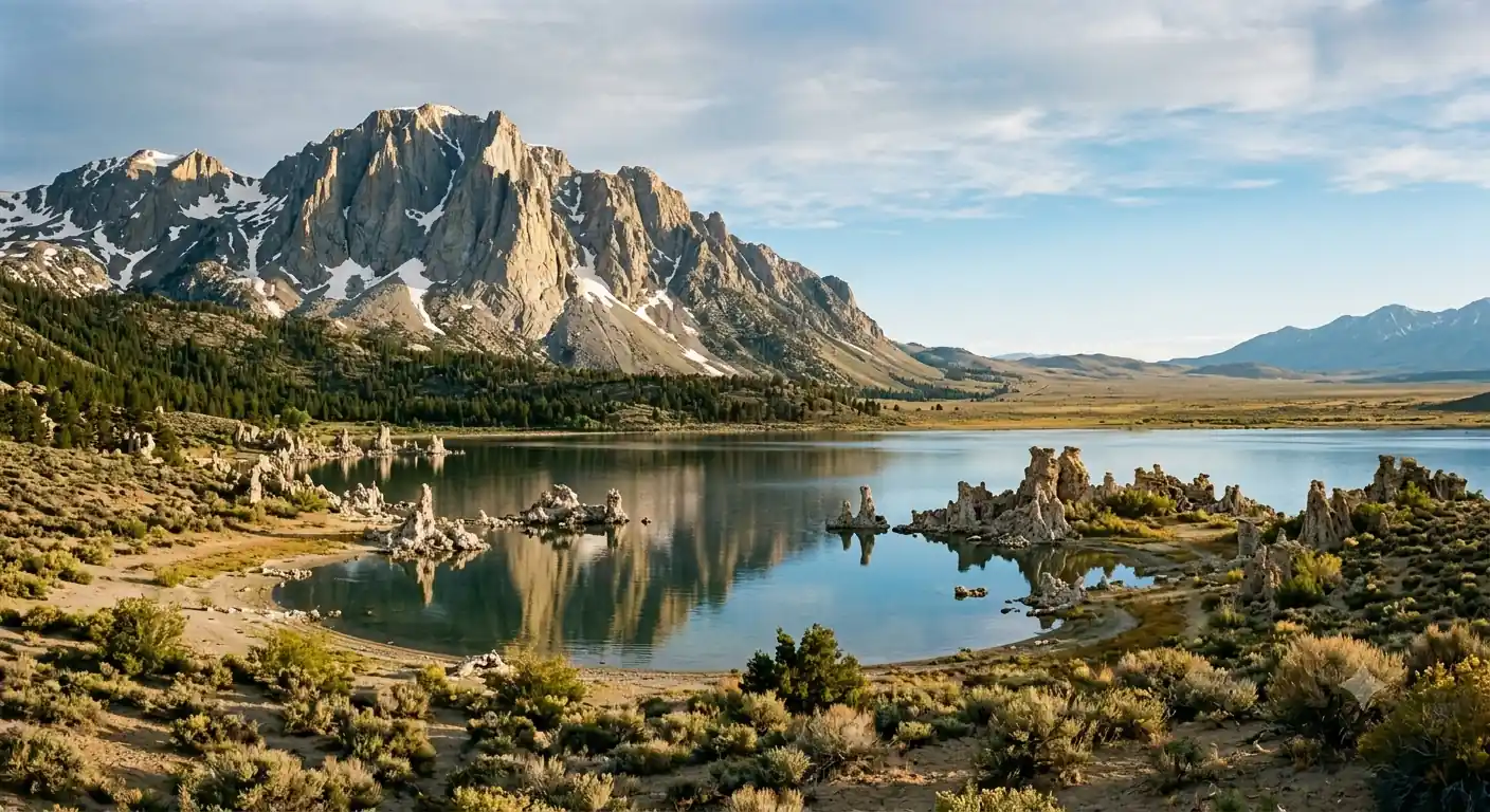
Rainbow FallsSan Joaquin RiverMono Lake Tufa Towers · 1.5 miles RT
Highway 395Back to baseDrive north on scenic Highway 395 to the Mono Lake South Tufa area, a globally significant saline lake nearly a million years old. The flat, 1.5-mile interpretive loop winds among otherworldly tufa towers, limestone spires that grew underwater and now stand exposed along the shoreline.
Sunrise and sunset light the towers best, and the lake hosts millions of migratory birds. Stop at a Highway 395 overlook for the wide view before driving the roughly 30 minutes back to Mammoth for the night.
- 1.5 mi loop · flat · interpretive signs
- Mono Lake overlookHighway 395 pullout · panoramic lake and Sierra views
- Sunrise or sunset shootBest light on the tufa · do not swim in the salty water
- Visit at sunrise or sunset for the most dramatic light on the tufa towers.
- There is a small per-person fee at South Tufa; the Mono Basin Visitor Center in Lee Vining is worth a stop.
- The water is highly saline and alkaline, so don't swim; watch for the huge migratory bird populations instead.
June Lake Loop & Parker Lake · 2–5 miles
Drive the picturesque June Lake Loop (Highway 158), a 16-mile ribbon past four alpine lakes: June, Gull, Silver, and Grant. It's famous for aspen color in late September and popular for fishing, boating, and photography all summer.
Stretch your legs on the moderate hike to Parker Lake, a jewel-blue tarn tucked beneath the Sierra crest, about 3.6 miles round trip. If you'd rather stay by the water, rent a kayak or paddleboard on June Lake before driving back to Mammoth.
- Drive the June Lake LoopHighway 158 · 16 mi · four alpine lakes
- 3.6 mi round trip · ~700 ft gain · moderate
- Kayak or paddleboard June LakeRentals at the marina · calm, beginner-friendly water
- Parker Lake's trailhead is up a dirt road off the loop; any car can usually reach it, but drive slowly.
- Late September to early October brings peak aspen color along the June Lake Loop.
- Bring layers and sun protection; the trail is exposed and afternoon winds pick up on the lakes.
Parker LakeRitter Range viewsConvict Lake & Laurel Lakes · 2.5–8 miles
Laurel high countryBack to baseDrive 15 minutes south to Convict Lake, a stunning glacial lake framed by dramatic peaks and named for an 1871 shootout with escaped convicts. The easy 2.5-mile shoreline loop is family-friendly and endlessly photogenic, especially in morning light.
For a bigger day, add the strenuous climb toward Laurel Lakes, roughly 8 miles round trip and 2,000 ft of gain, for panoramic views over the Convict basin. The upper road is rough and best for high-clearance vehicles, so most hikers walk it.
- 2.5 mi loop · ~100 ft gain · easy, family-friendly
- 8 mi round trip · 2,000 ft gain · strenuous
- Photograph the cirqueBest light early morning · reflections on the lake
- The Convict Lake loop is easy and mostly flat; part of it is wheelchair accessible.
- The Laurel Lakes road is rough and narrow; unless you have a high-clearance vehicle, plan to hike it.
- Go early for calm water and reflections, and to beat afternoon thunderstorms on the higher trail.
Mammoth Gondola & Mammoth Crest · 4–7 miles
Ride the scenic gondola from the Mammoth Mountain Main Lodge to the 11,053-ft summit for a 360-degree panorama of the Eastern Sierra, with an interpretive center and restaurant at the top. This is the trip's high point without the climb.
From the summit or the Lakes Basin, hike a section of the exposed Mammoth Crest, 4 to 7 miles round trip with big views into the Ansel Adams Wilderness, the Ritter Range, and the Owens Valley. Save the evening for a celebratory last dinner in town.
- Scenic gondola to the summit11,053-ft summit · interpretive center & views
- 4–7 mi round trip · 1,000–1,500 ft gain · above 10,000 ft
- Celebratory dinner in townLast night in Mammoth Lakes
- The crest is fully exposed above 10,000 ft, so carry sun protection, layers, and plenty of water.
- Start early to beat afternoon thunderstorms, which build fast over the Sierra in summer.
- Check gondola operating hours and the last downhill ride so you're not caught at the summit.
Mammoth MountainRitter RangeDeparture from Mammoth Lakes
Highway 395Northbound detoursEnjoy a final Eastern Sierra breakfast or an easy morning walk before beginning the drive home. If you're heading north, a detour to the Bodie ghost town rewards the miles; heading south, the Alabama Hills near Lone Pine make a spectacular last stop under Mount Whitney.
From Mammoth it's about 3 hours to Reno-Tahoe (RNO) and 5 to 6 hours to Los Angeles, so plan your departure time around your flight or drive.
- Final breakfast or short walkOne more morning in the mountains
- Drive home via Highway 395Bodie ghost town north · Alabama Hills south
- If flying, note Mammoth Yosemite (MMH) has limited service; Reno-Tahoe (RNO) is the usual gateway at ~3 hours.
- Driving north, Bodie State Historic Park is a worthwhile detour; driving south, stop at the Alabama Hills.
- Fuel up in town before you go, as gas is sparse and pricey along stretches of Highway 395.
Now build your Eastern Sierra trip.
You've seen all ten days. Open the free drag-and-drop planner and tune it for your dates, your pace, and whether you keep the Minaret Lake backpack or swap in more day hikes from your Mammoth Lakes base.
Essential wilderness rules & planning.
Wilderness permits are competitive
Overnight permits are required for all backpacking in the John Muir and Ansel Adams Wilderness (Inyo National Forest) and are quota-controlled. Reservations open on Recreation.gov roughly six months ahead, so a July trip means booking in January. Cost is about $6 per person plus a small reservation fee; check current rates.
Bear canisters are mandatory
Bear-resistant canisters are required for every overnight stay in these wildernesses, and rangers check for compliance. You can rent one in Mammoth Lakes. Store all food and scented items inside, and never leave it near your tent.
Devils Postpile is shuttle-access
In peak season (mid-June to early September) private vehicles are barred from Reds Meadow Road between 7 AM and 7 PM. Ride the mandatory shuttle from the Mammoth Mountain Adventure Center; buy tickets there or online. An America the Beautiful pass covers the monument entrance.
Go July through September
July and August clear the high passes of snow and bring wildflowers, warm days, cool nights, and frequent afternoon thunderstorms. September means cooler temperatures, thinner crowds, and aspen color. Early October is possible but risks early snow and shuttle closures.
Acclimatize and treat water
Most trailheads sit above 7,000 ft and the crest tops 10,000 ft, so ascend gradually and watch for altitude sickness. Filter or treat all water from natural sources, and pack out or properly bury human waste 200 ft from water, trails, and camp.
Getting there needs a car
Mammoth Yosemite Airport (MMH) has limited flights; most visitors fly into Reno-Tahoe (RNO) and drive about 3 hours, or drive from Los Angeles (5–6 hours) or San Francisco (6–7 hours). A car is essential for the day trips along Highway 395.
Everything you'll actually want to know.
Ready to go? Get your
Eastern Sierra route.
Trailheads and mileages, the wilderness permit and bear-canister rules, the mandatory Reds Meadow shuttle, drive times up Highway 395, and the acclimatization plan you need to pair a Minaret Lake backpack with the region's best day trips.
Instant book · Free cancellation · Secure payment via Stripe


Planning this trip?
Save it, share it with your crew, or find travelers heading the same way.

Liked this itinerary?
What other travelers are saying
Be the first to leave a tip or question for the next traveler.