Black Creek Wilderness Map +
6-Day Float & Backpack Itinerary
A 6-day Black Creek Wilderness trip in Mississippi's De Soto National Forest. Paddle the 21-mile Wild & Scenic float from Big Creek Landing past Moody's and Janice to Fairley Bridge, camping on white-sand bars, then backpack the Black Creek Trail through the state's only designated wilderness.
Free interactive planner · drag & reorder your days, add stops, map it in minutes
Build your own Black Creek trip, drag, reorder & map it.
Drag landings and camps between days, swap the float legs, and add your own sandbar camps or trail miles with the place search. The live map and legs recalculate as you go, so you can tune the paddle-and-backpack route to your pace before you lose cell service in the wilderness.
Opens a side panel · reorder days, add custom stops, see your route live
Float and backpack Mississippi's only wild river, De Soto National Forest.
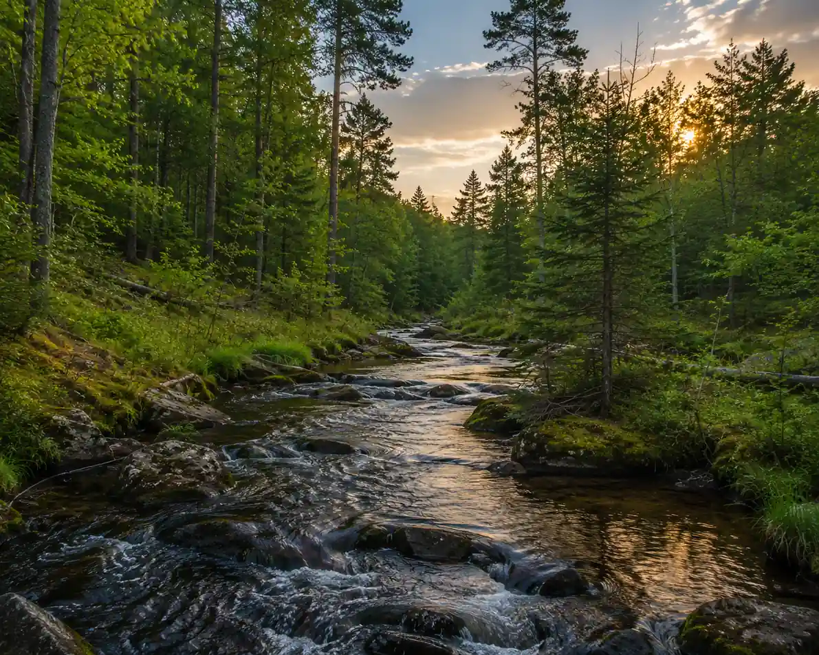
The Black Creek Wilderness sits inside the De Soto National Forest and protects Mississippi's only designated Wild & Scenic river. This 6-day itinerary pairs a multi-day canoe float with a Black Creek Trail backpack, so you experience the blackwater, white-sand bars, and old-growth bottomland forest from both the water and the trail.
The float runs downstream from Big Creek Landing past Moody's Landing and Janice Landing to Fairley Bridge Landing, roughly 31 river miles that include the 21-mile Wild & Scenic section from Moody's to Fairley Bridge. You then backpack a stretch of the ~40-mile Black Creek Trail, about ten miles of which run through the wilderness itself.
No permits are required, and there are no user fees, though self-registration at the trailheads and landings is encouraged so the Forest Service can track use. October through April is the season to go: mild temperatures, far fewer mosquitoes, and reliable water levels. Base your logistics out of Brooklyn, Mississippi, the closest town to the access points.
There are no reservations or fees for the wilderness float or the Black Creek Trail, but you do need to arrange a two-vehicle shuttle or hire a local outfitter in Brooklyn for canoe rental and drop-off. Developed campgrounds and lodging near Brooklyn and Hattiesburg are limited, so book any pre- or post-trip room early, especially on fall and spring weekends.
Arrive in Brooklyn & Gear Check
Your Black Creek Wilderness trip begins in Brooklyn, Mississippi, the closest town with services to the river access points and about an hour's drive from Gulfport-Biloxi International Airport (GPT). Use the day to gather last-minute supplies, check gear, and stage vehicles for the shuttle.
Services are limited around Brooklyn, so stock up on food, water containers, and fuel before you arrive. Organize your dry bags, confirm your shuttle or outfitter plan, and get a good night's rest. Nearby Hattiesburg, roughly 25 minutes north, has more hotels and full grocery if you need them.
- Drive to Brooklyn, MS~1 hr from Gulfport-Biloxi (GPT) · base town for logistics
- Gear check & dry-bag packingFilter, PFDs, tent, stove · no drinking water on the trail
- Or hire a Brooklyn outfitter for canoe rental + drop-off
- Brooklyn has limited services, so buy all food, fuel, and water containers before you leave Hattiesburg or the coast.
- No drinking water is available on the Black Creek Trail and all creek water must be filtered or treated, so plan your capacity accordingly.
- A two-vehicle shuttle (or a local outfitter drop-off) is essential for a point-to-point float and backpack, so lock it in before day two.
Black CreekSand bars aheadLaunch at Big Creek & Paddle to Moody's Landing · ~10 miles
On the waterMoody's campShuttle a vehicle down to Fairley Bridge Landing (your float take-out and trail start), then launch your canoe or kayak at Big Creek Landing, the northern terminus of the float and the Black Creek Trail. Secure everything in dry bags before you push off.
Paddle roughly 10 downstream miles of calm, tannin-dark water through serene bottomland forest to the Moody's Landing area, where the 21-mile Wild & Scenic section officially begins. Pitch a primitive camp on one of the many white-sand bars, and practice strict Leave No Trace.
- Shuttle a vehicle to Fairley Bridge~40 min drive · your float take-out & trail start
- Concrete ramp · northern terminus · no fees
- ~10 mi · 4–6 hrs · calm bottomland float
- Primitive camp on a sand barLeave No Trace · camp 200 ft from trails & water
- Set your shuttle before you launch: leave one vehicle at Fairley Bridge Landing and drive the other to Big Creek Landing to put in.
- The current is gentle and mostly flatwater, but keep gear lashed in dry bags in case you tip on a strainer or a shallow bar.
- Choose a flat, open sand bar well above the waterline to camp, and bury human waste 6–8 inches deep at least 200 feet from the creek.
Moody's Landing to Janice Landing · ~9 miles
Continue downstream from Moody's Landing through the heart of the Wild & Scenic corridor. This stretch is lined with the white sand beaches Black Creek is known for, ideal for a long lunch, a swim, or drifting and watching for herons, turtles, and wood ducks.
Aim to reach Janice Landing by late afternoon. Janice is a popular put-in and take-out with a concrete ramp and a small primitive campground, so you can settle onto a nearby sand bar or an established site for the night. Filter all your water and pack out every scrap of trash.
- ~9 mi · white sand beaches · gentle current
- Swim & sandbar lunch breakClear tannin water · abundant bars for stops
- Primitive camp at Janice LandingConcrete ramp · small primitive campground · free
- This middle stretch has the most inviting sand beaches on the float, so build in extra time to swim and relax rather than rushing to camp.
- Janice Landing sees regular use, so arrive early enough to claim a good bar or established site before day paddlers and other campers.
- All creek water must be filtered or treated before drinking, no matter how clear it looks, so keep your filter accessible.
BlackwaterJanice campJanice Landing to Fairley Bridge · ~12 miles · Transition
Fairley BridgeTrail aheadThe last and longest float leg winds about 12 miles from Janice Landing through ancient cypress and tupelo bottoms to Fairley Bridge Landing, the downstream end of the Wild & Scenic river and the eastern trailhead of the Black Creek Trail.
Take out at Fairley Bridge, de-rig your boat, and load it onto your shuttle vehicle. Re-pack your backpacking gear for the trail portion and camp near the landing so you can start hiking early. Check for any current fire restrictions before you build a fire.
- Paddle Janice to Fairley Bridge~12 mi · cypress & tupelo bottoms · longest leg
- End of the float · eastern trailhead of the trail
- Re-pack & camp near Fairley BridgeTransition from paddle to backpack · check fire rules
- This is the longest paddle of the trip through cypress and tupelo bottoms, so start early and pace yourself to reach Fairley Bridge with daylight.
- De-rig and dry your boat at the take-out, then reorganize into your backpack, moving only what you need for two days on the Black Creek Trail.
- Campfires are usually allowed but check current De Soto National Forest fire restrictions, use existing rings, and drown any fire fully before sleep.
Black Creek Trail Backpacking · 8–10 miles
Trade the paddle for boots. From Fairley Bridge Landing, hike west on the Black Creek Trail, a ~40-mile National Recreation Trail that parallels the creek and passes through about ten miles of the Black Creek Wilderness itself. The tread is generally flat, sandy in places, and crosses countless small streams on over 100 bridges and boardwalks.
The trail gives you a completely different view of the wilderness, up on the drier upland pine ridges above the floodplain, with occasional overlooks of the creek. Cover 8–10 miles and set a primitive camp on a durable surface at least 200 feet from water and the trail. Filter water from the creek and follow Leave No Trace.
- ~40-mi NRT · ~10 mi inside the wilderness · foot travel only
- Cross bridges & boardwalks100+ crossings over streams and ponds · flat, sandy tread
- Primitive camp in the wildernessDurable surface · 200 ft from water & trail · filter all water
- The Black Creek Trail is well marked but carry a map and compass or GPS, since the sandy tread and many stream crossings can be disorienting.
- No drinking water exists along the trail, so filter and carry what you need between reliable creek access points.
- Camp on a durable surface at least 200 feet from water and the trail, and limit your group to 10 people or fewer to protect the wilderness.
Trail campCreek overlookHike Out & Departure · 8–10 miles
Last milesBack to BrooklynFinish the backpack by continuing along the Black Creek Trail to your exit point near Janice Landing, another 8–10 miles that trade the immediate riverbank for quiet pine ridges and hardwood draws. Pack out everything, including all trash and food scraps.
Retrieve your shuttle vehicle, clean and de-rig your gear, and grab a post-trip meal in Brooklyn or Hattiesburg. From here it is about an hour's drive south to Gulfport-Biloxi International Airport (GPT) if you are flying home.
- Hike out to Janice Landing~8–10 mi · pine ridges & hardwood draws · pack it all out
- Post-trip meal in Brooklyn or HattiesburgDe-rig gear · celebrate the float-and-backpack loop
- Drive to Gulfport-Biloxi (GPT)~1 hr south · refuel before the drive
- Leave No Trace to the end: carry out all trash, food scraps, and packaging so the wilderness stays pristine for the next paddlers and hikers.
- Cell service is unreliable to nonexistent in the wilderness, so carry a satellite messenger and tell someone your exit time and plan.
- Refuel and eat in Brooklyn or Hattiesburg before the roughly one-hour drive south to the Gulfport-Biloxi airport.
Now build your Black Creek trip.
You've seen all six days. Open the free drag-and-drop planner and tune it for your dates, your paddling pace, and how many miles of the Black Creek Trail you want to backpack out of your Brooklyn base.
Essential wilderness rules & planning.
Leave No Trace
Pack it in, pack it out, including all trash, food scraps, and packaging. Bury human waste 6–8 inches deep and at least 200 feet from water sources, trails, and campsites. The Black Creek Wilderness has no facilities in its interior.
Camping & campfires
Primitive camping is allowed on sand bars and at least 200 feet from trails and water. Campfires are generally permitted unless restrictions are in place, so use existing fire rings and make sure fires are completely out before you leave.
Group size & foot travel
Keep groups to 10 people or fewer to minimize impact. Only foot travel is permitted on the Black Creek Trail, and the float is limited to non-motorized canoes and kayaks in the Wild & Scenic corridor.
Go October through April
The best window is fall (October–November) and spring (March–April): mild temperatures, fewer insects, and good water levels. Winter is pleasant but cooler. Avoid May through September for extreme heat, humidity, and heavy mosquitoes.
Water & self-reliance
No drinking water is available on the trail, and all creek water must be filtered or treated. Cell service is unreliable or nonexistent in the wilderness, so carry a satellite communicator and be prepared to be fully self-reliant.
Shuttle, permits & getting there
No permits or fees are required, but self-registration is encouraged. A point-to-point float and backpack needs a two-vehicle shuttle or a Brooklyn outfitter drop-off. Base out of Brooklyn, MS, about an hour north of Gulfport-Biloxi International Airport (GPT).
Everything you'll actually want to know.
Ready to go? Get your
Black Creek Wilderness route.
Landings and river mileages, the two-vehicle shuttle plan, the Leave No Trace and camping rules, the best October-to-April window, and the paddle-and-backpack logistics you need to float and hike Black Creek in six days.
Instant book · Free cancellation · Secure payment via Stripe


Planning this trip?
Save it, share it with your crew, or find travelers heading the same way.

Liked this itinerary?
What other travelers are saying
Be the first to leave a tip or question for the next traveler.