Big Bend National Park Map +
3-Day Desert Hiking Itinerary
3-day Big Bend National Park itinerary. Hike the Window Trail into the Chisos Basin, tackle the South Rim & Emory Peak loop (the park's 7,832 ft high point), and walk into Santa Elena Canyon on the Rio Grande, three iconic hikes in one desert weekend.
Free interactive planner · drag & reorder your days, add stops, map it in minutes
Build your own Big Bend trip, drag, reorder & map it.
Drag stops between days, swap trails, and add your own overlooks and trailheads with the place search. The live map and drive legs recalculate as you go, so you can tune the route from the Chisos Basin to the Rio Grande to your pace before you lose cell service in the desert.
Opens a side panel · reorder days, add custom stops, see your route live
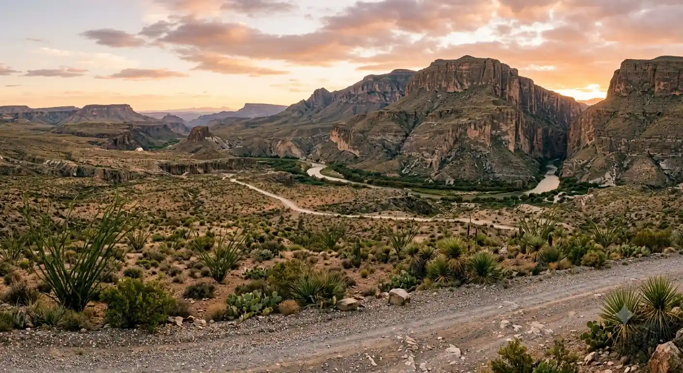
Three iconic hikes, Chisos to the Rio Grande, in one desert weekend.
For a 3-day trip to Big Bend National Park in far West Texas, base yourself in the Chisos Basin, the only lodging inside the park and the trailhead hub for the high country. This route packs the park's three signature hikes into a weekend: the Window Trail, the South Rim & Emory Peak loop, and Santa Elena Canyon on the Rio Grande.
You'll warm up on the Window Trail (5.5 miles) the first afternoon, commit to the strenuous South Rim loop (12.6 miles, with an optional Emory Peak spur to 7,832 ft) on day two, and finish with the easy walk into Santa Elena Canyon (1.7 miles) where 1,500-foot limestone walls squeeze the river between the US and Mexico.
No permit is required for day hiking. A backcountry permit ($10/night) is required only if you camp at a primitive site. Big Bend is a remote desert park with almost no cell service, so carry at least a gallon of water per person per day and fuel up before you enter. October through April is the season, summer heat routinely tops 100°F and makes hiking dangerous.
Chisos Mountains Lodge is the only in-park lodging and books out 6 to 12 months ahead for peak season (October through April), so reserve as early as you can at chisosmountainslodge.com. Chisos Basin and Rio Grande Village campgrounds are reservable up to 6 months out on recreation.gov; Cottonwood is first-come, first-served. Note that the lodge is running limited room availability through summer 2026, with full capacity expected back by September 2026.
Arrival & the Window Trail · 5.5 miles
Enter Big Bend, ideally via Persimmon Gap from Marathon or Maverick Junction from Terlingua, and drive straight up into the Chisos Basin, the only lodging inside the park. Check into Chisos Mountains Lodge or the basin campground, then shake out the drive on a moderate afternoon hike to acclimatize.
The Window Trail (5.5 miles round trip, ~1,000 ft) descends through Oak Creek Canyon to a dramatic pour-off that frames the desert beyond, the Chisos Basin's signature view and a perfect introduction to the mountains. Have dinner at the lodge dining room, the only full-service restaurant in the park, then step outside for the stargazing: Big Bend is an International Dark Sky Park with some of the darkest skies in the Lower 48.
- Enter via Persimmon Gap or Maverick Junction · fuel up first
- 5.5 mi RT · ~1,000 ft · 3 hours · moderate · pour-off view
- Dinner at Chisos Mountains LodgeOnly full-service restaurant in the park · sunset views
- Stargazing in the Chisos BasinInternational Dark Sky Park · bring a red-light headlamp
- Gas up in Marathon, Terlingua, or Study Butte before you enter, in-park fuel is limited to Panther Junction and the Basin store.
- The Window Trail descends on the way out, so you climb ~1,000 ft back to the Basin on tired legs at the end. Save water for the return.
- Cell service is essentially non-existent across the park. Download offline maps before you arrive and tell someone your plan.
Chisos Basin baseDark-sky stargazingSouth Rim & Emory Peak · 12.6–15.6 miles
Emory Peak summitBoot CanyonThe big day. Start early from the Chisos Basin Trailhead and climb the South Rim loop (12.6 miles, ~2,000 ft) via Laguna Meadow, topping out on the escarpment for one of the great views in the Southwest, the Chihuahuan Desert falling away 2,000 feet to the Rio Grande and the Sierra del Carmen in Mexico beyond.
Add the optional Emory Peak spur (about 3 miles round trip, ~1,000 ft) to stand on the park's 7,832 ft high point, a short rock scramble at the very top, bringing the day to roughly 15.6 miles. Descend through Boot Canyon, named for the boot-shaped rock spire, back to the Basin. Pack 4–5 liters of water per person; there are no reliable water sources on the trail.
- 12.6 mi loop · ~2,000 ft · 7–9 hours · strenuous
- ~3 mi RT add-on · 7,832 ft summit · short final scramble
- Descend via Boot Canyon TrailLook for the boot-shaped rock spire · shadier, cooler section
- Second night in the Chisos BasinRest & recover · dining room open for dinner
- Start at first light. The full South Rim with Emory Peak is 8–10 hours, and much of the rim is exposed with no shade.
- Carry at least 4–5 liters of water per person, there are no reliable water sources on the loop and the desert air dehydrates you fast.
- The final push up Emory Peak is a short Class 2–3 scramble on rock. Skip the summit block in ice, wind, or wet conditions.
Santa Elena Canyon & departure · 1.7 miles
On the last morning, drop from the mountains to the river. Drive the Ross Maxwell Scenic Drive to the Santa Elena Canyon Trail (1.7 miles round trip, ~150 ft), an easy, iconic walk into a slot where 1,500-foot limestone walls squeeze the Rio Grande between Texas and Mexico. You cross Terlingua Creek, sometimes muddy or wet, before the trail climbs into the canyon.
On the way back, stop at the Castolon Historic District and the La Harmonia Store for a look at the park's ranching and border history, then begin the long drive out. Fuel up at Panther Junction or outside the park, roads out are long, isolated, and services are scarce.
- ~45 mi · winding paved road · Mule Ears & scenic overlooks
- 1.7 mi RT · ~150 ft · easy · 1,500 ft canyon walls
- Castolon Historic District & La Harmonia StoreHistoric trading post · restrooms · small exhibits
- Drive out of Big BendFuel up first · consider the Fossil Discovery Exhibit if exiting north
- Go to Santa Elena Canyon early, the low-angle light on the canyon walls is best in the morning and it beats the crowds.
- Terlingua Creek at the trailhead can be muddy or ankle-deep after rain; sandals or a willingness to get wet feet help.
- The drives out of Big Bend are long and remote. Top off your tank at Panther Junction and carry extra water in the car.
CastolonRoss Maxwell DriveNow build your Big Bend trip.
You've seen all three days. Open the free drag-and-drop planner and tune it for your dates, your pace, and whether you add more Chisos trails or a float trip on the Rio Grande around your Chisos Basin base.
Essential desert-park logistics & planning.
Water is life in the desert
Carry a minimum of one gallon (4 liters) per person per day, and 4–5 liters for the South Rim. There are no reliable natural water sources on the trails. Potable water is available at Panther Junction, the Chisos Basin, and Rio Grande Village, top off every time you pass one.
Remote park, almost no cell service
Cell service is extremely limited to non-existent across Big Bend. Download offline maps before you arrive, tell someone your itinerary, and consider a satellite messenger. Fuel is only sold at Panther Junction and the Basin store, so fill up in Marathon, Terlingua, or Study Butte on the way in.
Permits & backcountry rules
Day hiking needs no permit. A backcountry permit ($10/night) is required for any primitive roadside or backcountry campsite, obtained in person at Panther Junction or the Chisos Basin Visitor Center up to 24 hours ahead. Pack out all waste, campfires are prohibited in the backcountry.
Lodging books out early
Chisos Mountains Lodge is the only in-park lodging and fills 6–12 months ahead for October–April. Chisos Basin and Rio Grande Village campgrounds are reservable up to 6 months out on recreation.gov; Cottonwood is first-come, first-served. Terlingua and Marathon have outside-the-park options.
Go October through April
The season runs October through April, when temperatures are pleasant for hiking. Summer (May–September) routinely tops 100°F and makes desert hiking dangerous. Spring brings wildflowers but also crowds and strong winds. The mountains stay cooler than the desert floor year-round.
Entrance fee & getting there
A 7-day vehicle pass is $30 (the America the Beautiful annual pass is accepted). The nearest airports are Midland (MAF) at about 3–3.5 hours and El Paso (ELP) at about 4.5–5 hours; a car is essential, there is no public transit into the park.
Everything you'll actually want to know.
Ready to go? Get your
Big Bend National Park route.
Trailheads and mileages, the backcountry-permit and camping rules, the Chisos Basin lodging window, water and fuel strategy, drive times from Midland and El Paso, and the early-start timing you need to link three signature hikes in a weekend.
Instant book · Free cancellation · Secure payment via Stripe


Planning this trip?
Save it, share it with your crew, or find travelers heading the same way.

Liked this itinerary?
What other travelers are saying
Be the first to leave a tip or question for the next traveler.