Beartooth Highway Map +
5-Day Road Trip Itinerary
5-day Beartooth Highway road trip from Red Lodge, Montana over the 10,947-ft Beartooth Pass to Yellowstone's Northeast Entrance, the Lamar Valley, Cody, Wyoming, and back along the Chief Joseph Scenic Byway.
Free interactive planner · drag & reorder your days, add stops, map it in minutes
Build your own Beartooth road trip, drag, reorder & map it.
Drag stops between days, swap in your own overlooks and hikes with the place search, and let the live map and drive legs recalculate as you go. Tune the Beartooth Highway loop to your pace before you head above the treeline and lose cell service.
Opens a side panel · reorder days, add custom stops, see your route live
The most beautiful drive in America, Red Lodge to Yellowstone, in five days.
The Beartooth Highway is a National Scenic Byway that Charles Kuralt famously called "the most beautiful drive in America." This 5-day road trip runs from Red Lodge, Montana over the 10,947-ft Beartooth Pass to the Northeast Entrance of Yellowstone National Park, through the wildlife-rich Lamar Valley, down to Cody, Wyoming, and back over the Chief Joseph Scenic Byway.
You'll base out of three gateway towns, Red Lodge (elevation 5,549 ft), rustic Cooke City just outside Yellowstone, and Old-West Cody. Expect switchbacks, high-alpine tundra, glacial lakes, bison herds, and geology that spans billions of years, all reachable by car with a handful of short optional hikes.
No permit is required to drive the highway itself, but Yellowstone charges a $35-per-vehicle entrance fee (valid 7 days). The pass is only open roughly late May through mid-October; late June through early October is the sweet spot for wildflowers, stable weather, and open trails. This is prime grizzly country, so carry bear spray and know how to use it.
Lodging in the small gateway towns fills up fast in July and August. Book Red Lodge, Cooke City, and Cody hotels 3–6 months out, and any Yellowstone in-park lodging or campground 6–12 months out. Always check the Montana (MDT) and Wyoming (WYDOT) road-condition sites before you go, the Beartooth Pass can close for snow even in summer.
Arrive in Red Lodge & Beartooth Pass East · 40 mi
Fly into Billings Logan International (BIL) and drive the ~60 miles (1.5 hours) south to Red Lodge, Montana, a historic mining town at 5,549 ft and the eastern gateway to the Beartooth Highway. Settle in and stroll the charming downtown of shops, breweries, and restaurants.
To acclimate to the elevation, drive the first ~20 miles of the highway up to Rock Creek Vista Point (~9,200 ft), a popular overlook with restrooms and interpretive signs above the Rock Creek drainage. This east section throws down dramatic switchbacks and your first taste of high-alpine scenery. Return to Red Lodge for dinner.
- Fly into Billings & drive to Red Lodge~60 mi · 1.5 hr on US-212 S · rental car required
- Beartooth Highway east section to Rock Creek Vista~20 mi · 1–1.5 hr · switchbacks & first overlooks
- Rock Creek Vista Point~9,200 ft · restrooms · interpretive signs · often windy
- Dinner & overnight in Red LodgeLocal pubs, pizza, and breweries · book lodging ahead
- Billings Logan International (BIL) is the most convenient airport, about 1.5 hours from Red Lodge; Bozeman (BZN) and Jackson Hole (JAC) are farther.
- Drive the east section slowly on day one to acclimate; the road climbs fast with tight hairpins and you gain thousands of feet of elevation.
- Fuel up in Red Lodge, services are sparse once you are on the plateau, and gas is far cheaper here than in the small gateway towns.
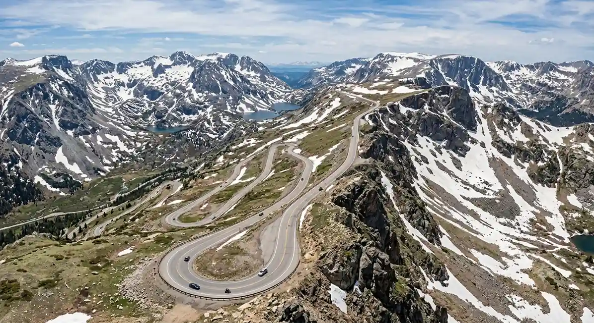
Red LodgeRock Creek VistaBeartooth Pass & Yellowstone's Northeast Entrance · 68 mi
Cooke CityLamar ValleyToday you conquer the full Beartooth Highway, cresting at Beartooth Pass (10,947 ft), the highest point in the region. Above the treeline the road crosses open tundra, glacial lakes, and dramatic peaks, with snow patches often lingering into July. Take your time at the pull-offs and 360-degree summit views.
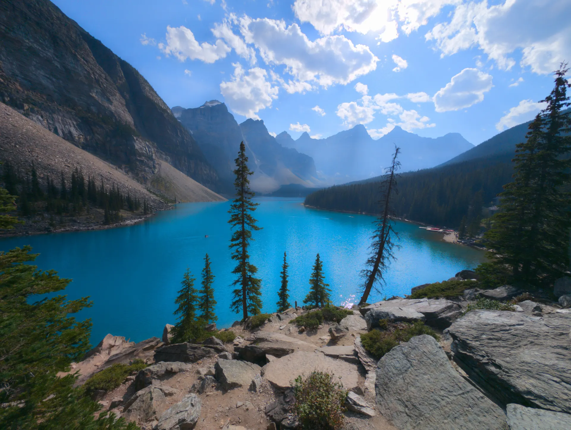
For an easy leg-stretcher, walk the short trail to Island Lake, a beautiful alpine lake off US-212. Descend into rustic Cooke City (7,608 ft), the last services before Yellowstone's Northeast Entrance, then enter the park and spend the afternoon in the wildlife-rich Lamar Valley.
- Beartooth Highway full drive68 mi · 3–4 hr · Red Lodge to Cooke City · above treeline
- Beartooth Pass summit10,947 ft · panoramic views · restrooms · cold & windy
- Easy alpine-lake stroll off US-212 · good for all ages
- $35/vehicle fee · 15 mi to prime wildlife viewing
- Bring warm layers even in August; the pass is often 20–30°F colder than Red Lodge and windy, with snow patches into midsummer.
- Cooke City has very limited lodging and dining, so book ahead and top off your gas tank, it is the last services before the Northeast Entrance.
- For wildlife in the Lamar Valley, aim for early morning or late evening and use pull-offs, never stop in the road.
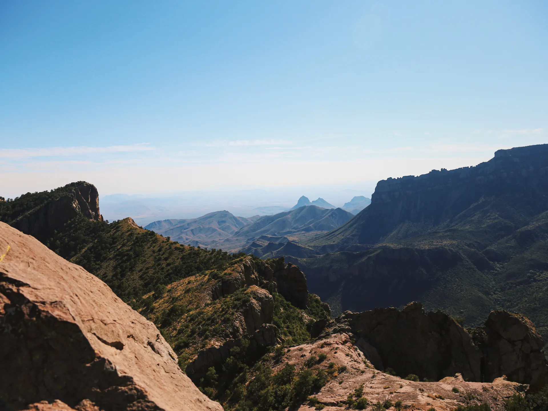
Lamar Valley, Tower-Roosevelt & Drive to Cody · 80 mi
Spend the morning on the Lamar Valley wildlife drive, often called "America's Serengeti," scanning for bison herds, elk, pronghorn, and, if you're lucky, wolves or bears. Continue to the Tower-Roosevelt area for Tower Fall, a 132-ft plunge reached by a short paved path, and the roadside Petrified Tree, a fossilized redwood from Yellowstone's ancient forests.
In the afternoon, exit the park via the East Entrance and drive the Buffalo Bill Scenic Byway along the North Fork of the Shoshone River to Cody, Wyoming (5,016 ft), passing Buffalo Bill's Pahaska Tepee hunting lodge and the reservoir near town. Check into your Cody lodging for the night.
- Lamar Valley wildlife drive~20 mi · 2–4 hr · bison, elk, pronghorn, wolves · bring binoculars
- 0.5 mi RT · paved overlook · 132-ft waterfall
- Petrified TreeShort walk · fossilized redwood · Specimen Ridge fossil forests
- Drive to Cody via East Entrance~80 mi · 1.5–2 hr · Buffalo Bill Scenic Byway along the Shoshone
- Wolves and bears are most active at dawn and dusk; a spotting scope dramatically improves your odds in the wide-open Lamar Valley.
- Keep 100 yards from bears and wolves and 25 yards from bison and elk, they are wild and unpredictable, especially in rut.
- The East Entrance road (Buffalo Bill Scenic Byway) is one of the most scenic exits from Yellowstone; leave time for the canyon and reservoir stops.
Tower FallCody, WYCody, Wyoming & the Chief Joseph Scenic Byway · 100 mi
Buffalo Bill CenterCooke CitySpend the morning in Cody, the "Rodeo Capital of the World," founded by Buffalo Bill himself. Tour the Buffalo Bill Center of the West, five museums under one roof covering Western art, firearms, natural history, and Plains Indian culture, and if you're visiting June–August, catch the nightly Cody Nite Rodeo.
In the afternoon, drive the Chief Joseph Scenic Byway (WY-296), a spectacular alternative that connects Cody back toward the Beartooth Highway near Cooke City. It crosses Dead Indian Pass and the Sunlight Creek Bridge (Wyoming's highest) with sweeping views of the Absaroka Mountains and Sunlight Basin. Overnight in Cooke City to set up tomorrow's return drive.
- Five museums · plan 3–4 hr · admission applies
- Nightly Jun–Aug · America's longest-running nightly rodeo
- Chief Joseph Scenic Byway (WY-296)~47 mi · 1.5–2 hr · Dead Indian Pass · Sunlight Basin
- Overnight in Cooke CityPositions you for the return drive over Beartooth Pass
- Give the Buffalo Bill Center of the West at least 3–4 hours; it is genuinely five museums and the best rainy-day option on the route.
- The Chief Joseph Scenic Byway carries far less traffic than the Beartooth Highway but is just as scenic, don't skip the pull-off at Dead Indian Pass.
- If you prefer, you can flip the loop and drive Chief Joseph in the opposite direction; the planner lets you reorder the whole day.
Beartooth Highway West & Departure · 128 mi
On your final day, drive the Beartooth Highway one more time, west to east from Cooke City back to Red Lodge. The changing light and reversed perspective reveal overlooks you rushed past on Day 2, and the long descent into Rock Creek Canyon is a fitting finale. Stop for a short optional walk near the Gardner Lake Trailhead if you have time.
From Red Lodge, continue north ~60 miles on US-212 to Billings Logan International Airport (BIL) for your departure. Allow extra buffer for wildlife, weather, and traffic in Billings before you return the rental car and fly home.
- Beartooth Highway west section68 mi · 2 hr · Cooke City to Red Lodge · reversed light
- ~1.5 mi RT · 300 ft · lake & peak views · can be snowy early
- Drive to Billings airport (BIL)~60 mi · 1.5 hr on US-212 N · return rental & depart
- Driving the pass a second time in the opposite direction is worth it; morning light on the plateau is completely different from the afternoon.
- Leave a generous buffer to the airport, the descent is slow, and wildlife or weather can add time at any point.
- Check the MDT and WYDOT road-condition sites the night before; the pass can close for snow with little warning even in September.
Beartooth PlateauBack in Red LodgeNow build your Beartooth road trip.
You've seen all five days. Open the free drag-and-drop planner and tune it for your dates, your pace, and whether you add more of Yellowstone or an extra night in Cody.
Essential road & wilderness rules & planning.
Mountain driving & road closures
The Beartooth Highway has steep grades, hairpin switchbacks, and elevations to 10,947 ft. Drive it comfortably in daylight, use low gears on descents, and be cautious at pull-offs. The pass is closed roughly mid-October to late May; always check the Montana (MDT) and Wyoming (WYDOT) road-condition sites, it can close for snow even in summer.
Bear safety, grizzly country
This is prime grizzly and black bear country. Carry bear spray, know how to deploy it, and make noise on trails. Store food in bear-resistant containers or hung, and never approach wildlife. Keep 100 yards from bears and wolves, 25 yards from bison and elk.
Yellowstone entrance fee & permits
A 7-day Yellowstone vehicle pass is $35 (check current rates), bought at any entrance station or on recreation.gov; there is no timed entry at the Northeast Entrance. No permit is needed to drive the highway. Overnight backcountry trips in Yellowstone need a permit (reservations open in January via recreation.gov, $10 plus $5/person/night).
Go late June through early October
Early summer brings wildflowers and snow-capped peaks but lingering snow on high trails. August to early September is the most stable, with fewer crowds than peak July. Late September to early October adds fall color at lower elevations, but expect cold and possible early snow closures on the pass.
Book gateway lodging early
Red Lodge, Cooke City, and Cody are small; book 3–6 months out for summer. Any in-park Yellowstone lodging or campground books 6–12 months out. Cooke City in particular has very limited beds and dining.
Pack for altitude & bring binoculars
Weather changes fast up high, so pack warm layers, a waterproof shell, and sun protection. Cell service is unreliable, carry physical maps or download offline navigation. Binoculars or a spotting scope transform the Lamar Valley wildlife viewing.
Everything you'll actually want to know.
Ready to go? Get your
Beartooth Highway route.
The drive legs and overlooks, the Yellowstone entrance fee and bear-country rules, when the pass is actually open, gateway-town lodging timing, and the Lamar Valley wildlife windows you need to make the most of five days.
Instant book · Free cancellation · Secure payment via Stripe

Planning this trip?
Save it, share it with your crew, or find travelers heading the same way.

Liked this itinerary?
What other travelers are saying
Be the first to leave a tip or question for the next traveler.