Assateague Island Map +
3-Day Oceanside Backpacking Itinerary
3-day Assateague Island backpacking itinerary. Hike the open Atlantic beach to a primitive oceanside campsite, camp two nights beside wild ponies and the surf, then hike out, all from the Maryland ranger station south of Ocean City.
Free interactive planner · drag & reorder your days, add stops, map it in minutes
Build your own Assateague trip, drag, reorder & map it.
Drag stops between days, swap the oceanside site, and add your own beach walks and dune trails with the place search. The live map and legs recalculate as you go, so you can tune the barrier-island route to your pace before you hike in past the last road.
Opens a side panel · reorder days, add custom stops, see your route live
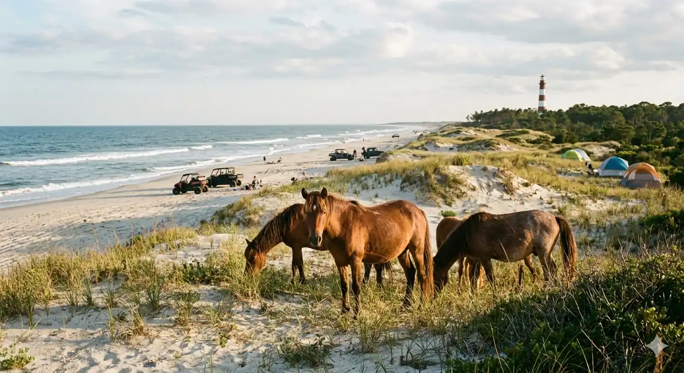
Two nights on a wild barrier-island beach, with the ponies.
For a weekend of backpacking in Maryland, few trips beat the primitive oceanside campsites of Assateague Island National Seashore. There is no elevation and no marked trail, just the open Atlantic beach, and the reward is two nights of solitude beside the surf where wild ponies roam free.
This 3-day plan checks in for a backcountry permit at the Maryland ranger station, then hikes roughly 4 miles south along the beach to the Little Levels oceanside site. You spend a full day exploring the dunes and shoreline, then hike back out on the third morning. It is moderate: no climbing, but soft sand and a full pack of water make the miles work.
Permits are first-come, first-served in person at the Maryland ranger station ($10 per person, valid up to 7 days), plus the park entrance fee. No fresh water exists at any backcountry site, so you carry it all in, and all food must be stored in a hard-sided container away from the ponies. Spring and fall are the sweet spots; summer is hot, buggy, and crowded.
Assateague's backcountry permits are not reservable online: they are issued in person at the Maryland ranger station (6633 Bayberry Drive, Berlin) on a first-come, first-served basis, $10 per person for ages 16 and up. Arrive early on weekends and holidays, when the two oceanside sites fill fast. Check in far enough before sunset to hike in with light (the ranger sets your cutoff by site). Front-country lodging is in Ocean City or Berlin, about 8 miles north.
Check In & Hike to Little Levels · 3–4 miles
Drive over the Verrazano Bridge onto the Maryland side of Assateague and stop first at the ranger station to buy your backcountry permit and get your site assignment. Top off every water bottle here, no fresh water exists past this point, then drive to the backcountry parking lot at the end of the paved road.
From the lot, shoulder your pack and hike south along the open beach to the Little Levels oceanside site, roughly 4 miles down the shore. There is no marked trail; the beach itself is the route. Pitch a freestanding tent behind the primary dune, lock all food into a hard-sided container away from the wild ponies, and settle in to the sound of the surf.
- 6633 Bayberry Drive · $10/person · first-come, in person
- Hike in to Little Levels oceanside site~4 mi south along the beach · soft sand · no marked trail
- Store food in a hard-sided containerPonies raid soft bags · keep all scented items sealed
- Fill every bottle and reservoir at the parking-lot spigot before you hike in. Plan on at least one gallon per person per day; there is no water at the campsites.
- Check in early enough to reach camp before dark. Rangers set a cutoff before sunset depending on how far your site is.
- A freestanding tent holds far better in loose sand than a stake-dependent one. Bring extra-long stakes or sand anchors as backup.
Ranger stationLittle Levels campExplore the Dunes, Shore & Ponies · 0–5 miles
The dunesThe shorelineWake to sunrise over the Atlantic and give the day to the island itself. Walk the shoreline for shells, scan the dunes for grazing wild ponies (keep at least 40 feet back, they are wild and can kick or bite), and watch for shorebirds working the wrack line. If you reserved consecutive nights at the same site, you can day-hike light; if you were assigned a second site, move camp a short distance south.
Swimming is possible but there are no lifeguards in the backcountry, so respect the currents. This is a slow day by design, the whole point of a barrier-island trip. After dark, the lack of light pollution makes for some of the best stargazing on the Mid-Atlantic coast.
- Beachcomb & watch for wild poniesStay 40+ ft back · never approach or feed the herd
- Shorebirding & shell walkingUndeveloped shoreline · collect shells, leave live shells
- Optional short interpretive dune loop near the campground
- Wild ponies are unpredictable and protected. Stay at least 40 feet away, never feed them, and store food and toiletries locked up even during the day.
- There is no shade on the beach. Bring a wide-brimmed hat, high-SPF sunscreen, and a long-sleeved sun shirt, and reapply after swimming.
- Watch the tide chart the ranger gives you. High tide narrows the beach, so time any longer shore walks for the outgoing tide.
Hike Out & Depart · 3–4 miles
Break camp with the cool morning air and hike north along the beach back to the backcountry parking lot, retracing your line up the shore. Do a careful Leave No Trace sweep first, including micro-trash and any buried waste; the island's dune ecosystem is fragile and heavily used. A full pack in soft sand is slow, so give yourself extra time.
Back at the car, an optional stop at the Assateague Island Visitor Center on the mainland side of the bridge has restrooms, water, and exhibits on the barrier-island ecology and the ponies. Then refuel in Berlin, a walkable historic town, or in Ocean City before you drive home.
- Hike out to the backcountry lot~3–4 mi north · easier in cool morning temps
- Mainland side · restrooms, water & barrier-island exhibits
- Lunch in Berlin or Ocean CityRefuel in a historic downtown before the drive home
- Do a final sweep for micro-trash and pack out everything, including food scraps. Human waste must be buried 6–8 inches deep and at least 200 feet from water and campsites.
- Hike out early. Cooler morning temperatures and firmer, damp sand near the tide line make the walk far easier with a loaded pack.
- Pets are prohibited in the backcountry and on the primitive beaches on the Maryland side, so leave the dog at home for this one.
Visitor centerThe hike outNow build your Assateague trip.
You've seen all three days. Open the free drag-and-drop planner and tune it for your dates, your pace, and whether you camp at Little Levels or hike the full stretch down to the State Line site.
Essential barrier-island rules & planning.
Store all food from the ponies
Wild ponies are drawn to food and will tear into soft bags and tents to get it. Store all food, trash, and scented items in a hard-sided container at all times, day and night, and never feed or approach the herd; stay at least 40 feet away.
Carry every drop of water
No fresh water is available at any backcountry site. Fill up at the parking-lot spigot and pack in at least one gallon per person per day. A filter is only a backup, since surface water on the island is brackish.
Permits are in-person, first-come
Backcountry permits are not reservable online. Get them at the Maryland ranger station (6633 Bayberry Drive, Berlin) on a first-come, first-served basis, $10 per person for ages 16 and up, valid up to 7 days, plus the park entrance fee. Weekends and holidays fill fast.
Go spring or fall
April through early June and September through October bring mild temperatures, fewer bugs, and clear days. Summer is hot, humid, and swarming with mosquitoes and biting flies; winter is cold, windy, and storm-prone. Bring strong insect repellent whenever it is warm.
Leave No Trace & no pets
Pack out all trash including micro-trash. Bury human waste 6–8 inches deep and 200 feet from water and camps. Small ground fires are allowed below the high-tide line using dead and downed wood only. Pets are prohibited in the backcountry.
Getting there needs a car
The Maryland entrance is at the end of MD-611, about 8 miles south of Ocean City, over the Verrazano Bridge. GPS often misroutes here, so download the park map. No public transit reaches the trailhead, and you drive to the backcountry lot before hiking in.
Everything you'll actually want to know.
Ready to go? Get your
Assateague Island route.
The in-person permit process, the beach mileage to Little Levels, the water and food-storage rules, the pony-safety distances, and the spring and fall timing you need to backpack Assateague in a weekend.
Instant book · Free cancellation · Secure payment via Stripe

Planning this trip?
Save it, share it with your crew, or find travelers heading the same way.

Liked this itinerary?
What other travelers are saying
Be the first to leave a tip or question for the next traveler.