Wrangell-St. Elias National Park:
A 4-Day Alaska Itinerary
Four days in America's largest national park: the McCarthy Road to the Kennecott Mines ghost town, the Root Glacier Trail and a guided ice hike, the Bonanza Mine climb, and bush-plane flightseeing over the Wrangell volcanoes.
Free interactive planner · drag & reorder your days, add stops, map it in minutes
Build your own Wrangell-St. Elias trip, drag, reorder & map it.
Drag stops between days, swap a glacier hike for a flightseeing tour, and add your own viewpoints with the place search. The live map and drive times recalculate as you go, and we'll warn you before you build a day that the McCarthy Road won't allow time for.
Opens a side panel · reorder days, add custom stops, see your route live
One park, volcanoes, glaciers & a copper ghost town, all in eastern Alaska.
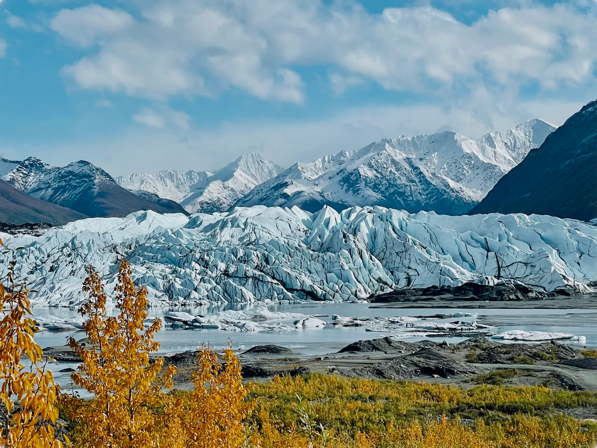
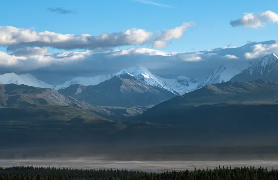
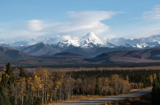
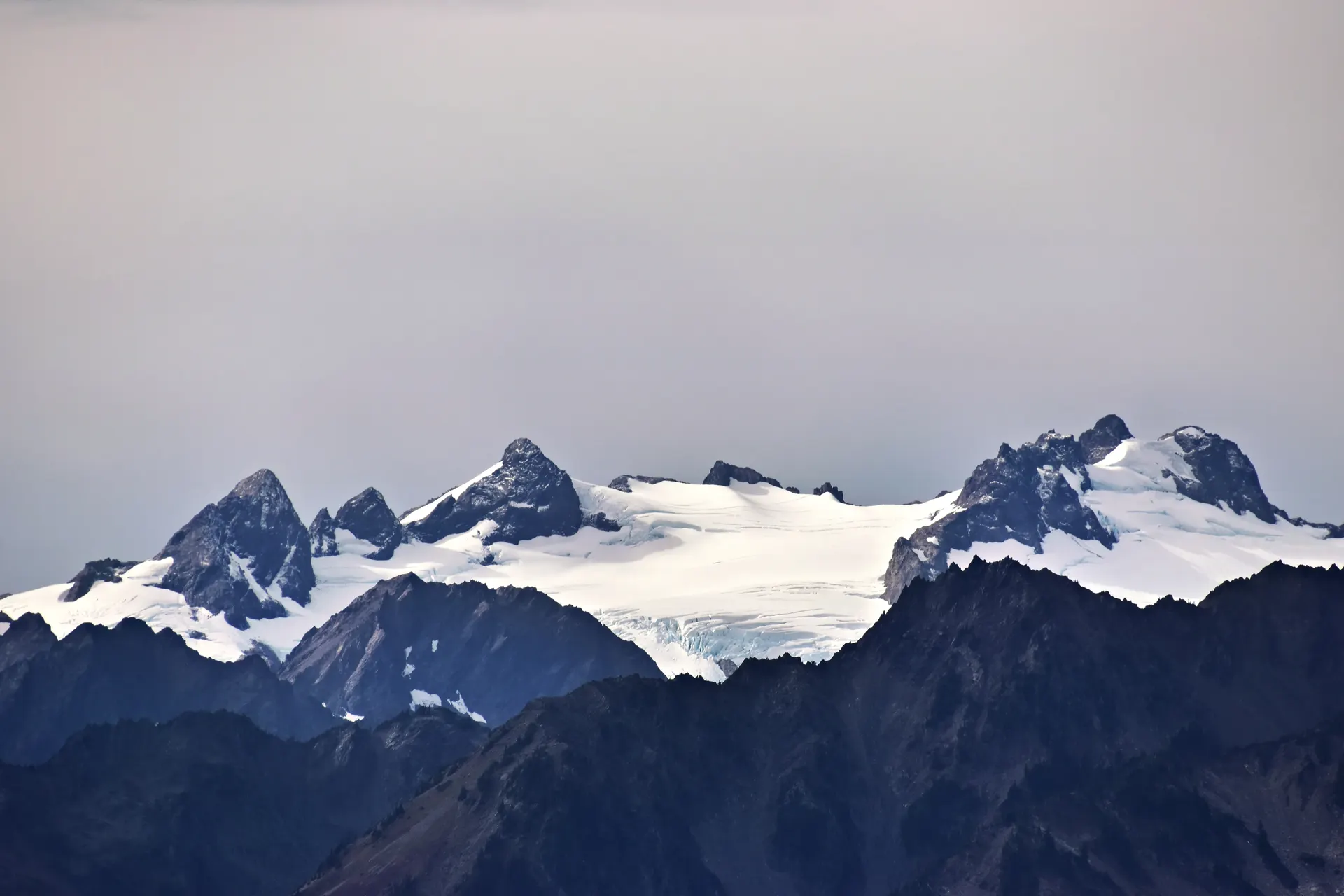
Wrangell-St. Elias is the largest national park in the United States: 13.2 million acres of eastern Alaska, bigger than Yellowstone, Yosemite, and Switzerland combined. It is a wilderness of towering volcanoes, vast icefields, and braided glacial rivers, with almost none of it reachable by road. The whole park is served by just two rough gravel roads and a scatter of bush-plane airstrips.
This 4-day route follows the classic way in: the McCarthy Road, about 60 miles of slow gravel that ends at a footbridge over the Kennicott River. From there you walk or shuttle into the tiny town of McCarthy and the Kennecott Mines, the red copper-mill ghost town and National Historic Landmark. You'll hike the Root Glacier Trail right onto the ice, take a guided ice hike, climb the strenuous Bonanza Mine Trail, and fly over the Wrangell volcanoes and the Bagley Icefield.
The window is short: late May to mid September. This is genuinely remote country with no cell service, limited services in McCarthy, and a long drive from Anchorage (about 7 to 8 hours). Book your lodging and the McCarthy Road shuttle, or fly in from Chitina, well ahead. Come prepared to be off the grid.
Lodging in McCarthy and Kennecott is limited and books up far ahead for the short summer season, so reserve early or base out in Copper Center or Glennallen. Book the McCarthy Road shuttle (or a flight in from Chitina) and any guided ice hike or flightseeing tour in advance too. There is no cell service past Chitina and few services in McCarthy, so fuel up, get cash, and download offline maps before you go.
Anchorage to Chitina & the McCarthy Road to the footbridge
This is a big driving day. From Anchorage (ANC) it is roughly 7 to 8 hours to McCarthy, so start early. The pavement ends at Chitina, the last real services and your last reliable fuel and cell signal. Top off your tank, grab cash and snacks, and check your spare tire before you commit to the gravel.
From Chitina, the McCarthy Road runs about 60 miles of slow, rough gravel along an old railbed, crossing the Kuskulana River bridge and ending at a footbridge over the Kennicott River. You cannot drive the last stretch into town: park at the end of the road, then walk across the footbridge and into McCarthy (or take a local shuttle the last few miles up to Kennecott). Settle into your lodging and let the quiet of the largest national park in the country sink in.
- The McCarthy Road~60 mi gravel from Chitina · slow, rough · 2 to 3 hr · ends at the footbridge
- Last services at ChitinaFuel, cash, snacks · no reliable cell service past here
- Walk the Kennicott River footbridgePark at the road's end · no driving into McCarthy
- Stay in McCarthy or KennecottLimited lodging · book far ahead for summer
- Chitina is your last fuel, cash, and cell service. Top off everything before the gravel, and carry a good spare tire and a jack for the McCarthy Road.
- The McCarthy Road is slow going, roughly 2 to 3 hours for 60 miles. Drive carefully, watch for sharp gravel, and leave plenty of daylight.
- You cannot drive into McCarthy. Park at the footbridge at the end of the road and walk in, or arrange a shuttle the last few miles up to Kennecott.

The Kennecott Mines ghost town & the Root Glacier Trail

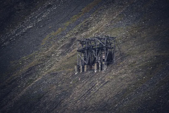
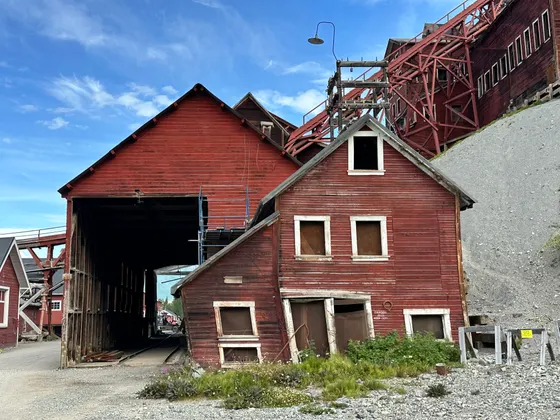
Spend the morning at the Kennecott Mines National Historic Landmark, the deep-red, 14-story copper mill and ghost town that operated until 1938 and now sits perfectly preserved above the glacier. Wander the mill buildings, the power plant, and the old company town, and consider a guided tour to go inside the mill, which is otherwise off limits.
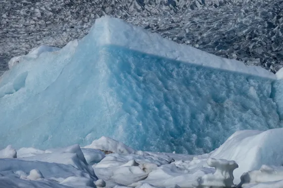
In the afternoon, hike the Root Glacier Trail (about 4 to 6 miles round trip depending on how far you go) out from Kennecott to the edge of the Root Glacier, where you can walk right onto the ice. The trail traverses moraine and meadow with huge views of the surrounding peaks, then drops you at the glacier's gleaming white toe.
- Red copper-mill ghost town · guided mill tours go inside · book ahead
- ~4 to 6 mi RT · moderate · walk onto the glacier ice
- Shuttle McCarthy to Kennecott~5 mi · local shuttle or walk the gravel road
- Second night in McCarthy or KennecottStay put for tomorrow's big mine-trail day
- The interior of the Kennecott mill is only accessible on a guided tour. Book one ahead to walk inside the 14-story building; the grounds themselves are free to wander.
- The Root Glacier Trail lets you step onto real glacier ice. Bring traction (microspikes) and warm layers even in summer, and stay off the ice if you are not equipped or guided.
- Kennecott sits about 5 miles uphill from McCarthy. A local shuttle runs between them, or you can walk the gravel road if you have the time and energy.
A guided ice hike or the strenuous Bonanza Mine Trail
Today is your big adventure day, and you have two great options. For the ice, book a guided ice hike on the Root Glacier: a local outfitter fits you with crampons and leads you out among the blue crevasses, moulins, and meltwater pools you cannot safely reach alone. It is the single best way to experience a living glacier up close.
If you would rather climb, take on the Bonanza Mine Trail (about 9 miles round trip, strenuous), a relentless switchbacking climb of roughly 3,800 feet from Kennecott up to the abandoned Bonanza Mine in the alpine. The reward is a jaw-dropping view back over the glaciers, the valley, and the Wrangell peaks. Pick one or the other: both are full days, and stacking a guided glacier hike on top of the Bonanza climb is more than most people can manage. Watch for bears, moose, and Dall sheep along the way.
- Crampons provided · crevasses, moulins & meltwater · book ahead
- ~9 mi RT · ~3,800 ft gain · alpine mine ruins · do INSTEAD of the ice hike
- Watch for wildlifeBears, moose, and Dall sheep · keep your distance · carry bear spray
- Third night in McCarthy or KennecottStay put for an early flightseeing slot tomorrow
- A guided ice hike is the safe, spectacular way onto the deeper glacier. Outfitters in Kennecott provide crampons and lead small groups; reserve ahead for summer.
- The Bonanza Mine Trail is a serious climb, about 9 miles round trip and roughly 3,800 feet of gain to alpine mine ruins. Start early, carry plenty of water, and turn around with time to spare.
- This is bear and moose country with Dall sheep in the high alpine. Carry bear spray, make noise on the trail, and give all wildlife a wide berth.

Flightseeing the Wrangell volcanoes, then the road back out
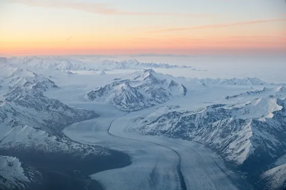
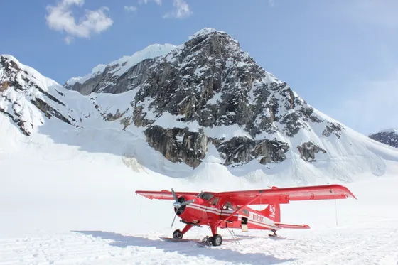
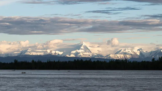
Save the view of a lifetime for last. A bush-plane flightseeing tour out of McCarthy lifts you over the heart of the park: the Wrangell volcanoes, the immense Bagley Icefield, and a maze of glaciers and unnamed peaks you can only truly grasp from the air. With 13.2 million acres almost entirely roadless, this is how you see the real scale of the largest national park in the country. If you have a spare hour, the braided Kennicott and Nizina rivers are also a classic packrafting run for the experienced.
Getting home: walk back across the footbridge to your car and retrace the McCarthy Road to Chitina, then on toward Anchorage. It is a long day, roughly 7 to 8 hours total, so leave with daylight to spare, top off your fuel and cell signal at Chitina, and take the gravel slow on the way out.
- Over the Wrangell volcanoes & Bagley Icefield · book ahead · weather-dependent
- Braided glacial rivers · for experienced paddlers or guided trips
- Getting home: the road back to AnchorageMcCarthy Road to Chitina, then ~7 to 8 hr total to ANC · go slow on gravel
- Flightseeing is the best way to grasp the park's scale, but it depends on weather. Book an early slot so you have flexibility to rebook if clouds roll in.
- Packrafting the Kennicott or Nizina rivers is a classic Wrangell adventure, but glacial rivers are cold and swift. Go with a guide or only if you are an experienced paddler.
- It is a long, remote drive out. Take the McCarthy Road slowly, refuel and check messages at Chitina, and leave plenty of daylight for the run back to Anchorage.
Now build your Wrangell-St. Elias trip.
You've seen all four days. Open the free drag-and-drop planner and tune it for your dates, your pace, and whether you base in McCarthy and Kennecott or out in Copper Center.
What we actually learned in Alaska's biggest park.
Two gravel roads in, and that's it
Almost all of Wrangell-St. Elias is roadless. Just two rough gravel roads reach into it: the McCarthy Road (about 60 miles to the footbridge for McCarthy and Kennecott) and the Nabesna Road on the park's north side. Everything else is bush plane or backpacking country.
Respect the McCarthy Road
The McCarthy Road is slow, rough gravel along an old railbed, roughly 2 to 3 hours each way. Carry a good spare tire and a jack, drive carefully over sharp gravel, and check whether your rental car company allows it. You park at the footbridge and walk or shuttle the rest of the way.
No cell service, limited services
There is no cell signal past Chitina and few services in McCarthy and Kennecott. Fuel up, get cash, and download offline maps in advance. Tell someone your plan, and bring everything you might need, because resupply out here is minimal.
Book lodging and shuttles early
Lodging in McCarthy and Kennecott is limited and fills fast for the short summer. Reserve early, or base out in Copper Center or Glennallen and drive in. Book the McCarthy Road shuttle, or a flight in from Chitina, ahead of time too.
Go late May to mid September
The season is short. Late May through mid September is the window, with the long Alaska daylight at its peak in June and July. Outside that, services close, the road and weather turn, and access becomes a serious expedition.
Come prepared for cold and wildlife
Even in summer, glacier ice and alpine ridges are cold and weather changes fast, so pack layers and rain gear. This is bear, moose, and Dall sheep country: carry bear spray, store food properly, and give all wildlife a wide berth.
Everything you'll actually want to know.
Ready to go? Get your
Wrangell-St. Elias route.
The McCarthy Road logistics, the Kennecott mill tour, the Root Glacier and Bonanza trails, guided ice hikes and flightseeing, drive times from Anchorage, and the off-grid prep you need to do this trip right.
Instant book · Free cancellation · Secure payment via Stripe
Planning this trip?
Save it, share it with your crew, or find travelers heading the same way.

Liked this itinerary?
What other travelers are saying
Be the first to leave a tip or question for the next traveler.