
Boulders, Oases & Dark Skies:
3 Days in Joshua Tree
Three days of the best hikes in Joshua Tree National Park: Hidden Valley and Barker Dam among the boulders, the Ryan Mountain summit, 49 Palms Oasis, the Cholla Cactus Garden, Keys View, and a night under one of the darkest skies in California.
Free interactive planner · drag & reorder your days, add stops, map it in minutes
Build your own Joshua Tree trip, drag, reorder & map it.
Drag stops between days, swap hikes, and add your own boulder fields and overlooks with the place search. The live map and drive times recalculate as you go, and we'll warn you before you build a day no one survives in the desert heat.
Opens a side panel · reorder days, add custom stops, see your route live
Two deserts, giant boulders & dark skies, in one park.
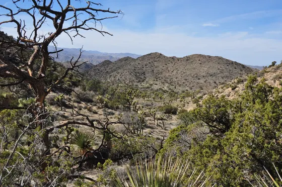
Joshua Tree National Park sits where two deserts meet: the higher, cooler Mojave in the west, dense with the park's namesake spiky Joshua trees and surreal piles of monzogranite boulders, and the lower, hotter Colorado Desert in the east, home to the Cholla Cactus Garden and wide ocotillo flats. Add some of the darkest night skies in Southern California and world-class rock climbing, and you have a park that rewards even a short visit.
This 3-day route is built around the best hikes in Joshua Tree: the easy Hidden Valley Loop and Barker Dam among the iconic boulders, the calf-burning Ryan Mountain summit for the best view in the park, and the desert-fan-palm oasis at 49 Palms. You'll mix the top short walks with drive-up highlights like Keys View over the Coachella Valley, the Cholla Cactus Garden at golden hour, and a proper Dark Sky night of stargazing.
October through April is the prime season, with comfortable days and cool nights. Spring is beautiful but busy. Summer is genuinely dangerous: daytime temperatures regularly top 100°F with no shade, so summer visits mean dawn hikes only. There is no water available in the park interior, so bring far more than you think you need.
There is no lodging inside Joshua Tree National Park, so book a room or rental in Joshua Tree town, Twentynine Palms, or Yucca Valley, all of which fill up on prime-season and full-moon weekends. There is no gas and no reliable water in the park interior, so fuel up and fill every bottle in town before you drive in, and bring far more water than you think you need.

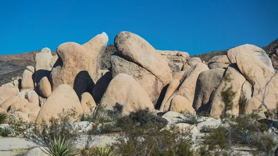

Into the boulders · Hidden Valley & Barker Dam
Enter through the West Entrance at Joshua Tree town, the closest gateway to the park's famous boulder country. Fuel up and fill every water bottle in town first, because there is no gas and no reliable water inside the park. Then drive in and ease into the day with the Hidden Valley Loop (about 1 mile, easy), a flat trail that threads into a bowl completely ringed by towering monzogranite boulders, once said to have hidden cattle rustlers.
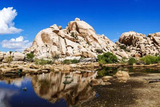
Next, hike Barker Dam Loop (about 1.3 miles, easy), which passes a small historic cattle dam that holds water after rain and a panel of Native American petroglyphs near the end. These two short loops are the perfect introduction to why people fall for Joshua Tree, and both sit close together off Park Boulevard, so you can take your time and still have the afternoon free for the climbers' boulders or a sunset spot.
- ~1 mi · easy · flat loop ringed by iconic boulders
- ~1.3 mi · easy · historic dam + petroglyphs
- Hidden Valley is world-class rock climbing · great to watch
- Stay in Joshua Tree townClosest base to the West Entrance · book ahead on weekends
- There is no gas and no reliable water inside the park. Fill your tank and every water bottle in Joshua Tree town before you drive through the West Entrance.
- Hidden Valley and Barker Dam are both short, mostly flat loops close together off Park Boulevard, making them an ideal, low-effort first afternoon.
- The West Entrance line can be long on weekend mornings. Arrive early or buy your entrance pass online ahead of time to skip the station wait.
Best hikes in Joshua Tree · Ryan Mountain & Keys View


This is the big hiking day. Start early with Ryan Mountain (about 3 miles round trip, roughly 1,000 feet of climbing, moderate), a steady switchbacking ascent to a summit with the best 360-degree view in the park, looking out over Lost Horse Valley, Queen Valley, and the surrounding boulder country. There is no shade, so hit the trailhead at first light and carry plenty of water.
In the afternoon, drive up to Keys View, a drive-up overlook perched at about 5,200 feet on the crest of the Little San Bernardino Mountains, with a sweeping panorama over the Coachella Valley, the San Andreas Fault, and on clear days the Salton Sea and Mexico beyond. On the way out, stop for the short walks at Skull Rock (about 1.7-mile loop) and Arch Rock (about 0.5 miles), two of the park's most photogenic rock formations.
- ~3 mi RT · ~1,000 ft · moderate · best summit view · start early
- Drive-up overlook · ~5,200 ft · Coachella Valley & San Andreas Fault
- ~1.7 mi loop · easy · the park's iconic skull-shaped boulder
- ~0.5 mi · easy · a natural granite arch near White Tank
- Ryan Mountain is about 3 miles round trip with roughly 1,000 feet of climbing and no shade. Start at first light and carry at least 2 to 3 liters of water per person.
- Keys View is a drive-up overlook and best at sunset, but the wind up there can be cold even when the desert floor is warm, so bring a layer.
- Skull Rock and Arch Rock are short, easy walks right off the main road, perfect to slot in between the summit hike and the overlook.
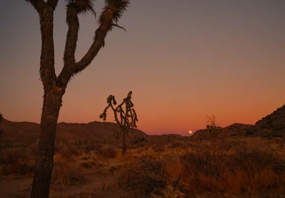
Oasis, cactus garden & dark-sky stargazing
Begin with a real desert hike to water: the 49 Palms Oasis (about 3 miles round trip, moderate), reached from a separate trailhead near Twentynine Palms, climbing over a rocky ridge to a hidden cluster of native California fan palms fed by a spring. It is one of the most rewarding hikes in the park, so go early before the canyon heats up. If you have energy and history interest, the Lost Horse Mine loop (about 4 miles round trip) and the Wall Street Mill (about 2 miles round trip) lead to some of the park's best-preserved gold-mining ruins.
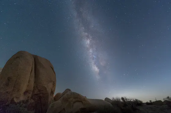
In the late afternoon, drive the long road southeast toward the Cholla Cactus Garden (about a 0.25-mile loop), where thousands of teddybear cholla light up like fur in the low sun, the easy walk that marks the transition into the lower Colorado Desert. Then stay out after dark: Joshua Tree is a certified Dark Sky park with world-class stargazing, and you can either set up on your own or join a guided stargazing or sightseeing tour with Joshua Tree Excursions to learn the desert and the night sky.
- ~3 mi RT · moderate · hidden fan-palm oasis · go early
- ~0.25 mi loop · easy · golden-hour glow · Colorado Desert
- Guided hiking, sightseeing & Dark Sky stargazing tour · book ahead
- Lost Horse ~4 mi RT · Wall Street Mill ~2 mi RT · gold-mining ruins
- The 49 Palms Oasis trailhead is off Canyon Road near Twentynine Palms, outside the main park loop. There is no shade until the oasis, so start early and carry water.
- Do not touch the teddybear cholla. The barbed segments detach easily and are painful to remove, so stay on the path and keep kids and dogs close.
- For stargazing, check the moon phase: a new-moon night is darkest. Let your eyes adjust for 20 minutes, use a red light, and bring warm layers for the cold desert night.
Now build your Joshua Tree trip.
You've seen all three days. Open the free drag-and-drop planner and tune it for your dates, your pace, and whether you base in Joshua Tree town, Twentynine Palms, or Yucca Valley.
What we actually learned in the desert.
Pay the entrance fee or bring your pass
Joshua Tree charges about $30 per vehicle for a 7-day pass. The annual America the Beautiful pass ($80) also covers entry and pays off fast if you visit other national parks. Buy it online ahead of time to skip the often-long line at the entrance station.
Bring far more water than you think
There is no reliable water in the park interior, just a few spigots at entrances and visitor centers. Carry at least a gallon per person per day, and 2 to 3 liters on a hike like Ryan Mountain or 49 Palms. There is almost no shade anywhere in the park.
Fuel up before you drive in
There is no gas inside Joshua Tree National Park. Fill your tank in Joshua Tree town, Twentynine Palms, or Yucca Valley before you enter. The park is large and the eastern Cholla Garden run is a long drive, so do not enter on a low tank.
Expect little to no cell service
Cell coverage is spotty to nonexistent across most of the park. Download offline maps, screenshot your trailheads, and tell someone your plan before you go. The visitor centers at the West Entrance, Oasis (Twentynine Palms), and Cottonwood have current trail and road info.
Go October through April
Fall, winter, and spring bring comfortable days and cool to cold nights, the best time for hiking and stargazing. Spring wildflowers can be spectacular but busy. Summer is genuinely dangerous: temperatures top 100°F with no shade, so any summer hiking should be done at dawn only.
There is no lodging inside the park
Stay in Joshua Tree town (closest to the boulders), Twentynine Palms (closest to 49 Palms and the Cholla road), or Yucca Valley. Rooms and rentals fill on prime-season and full-moon weekends. The park's campgrounds are first-come or reservable through recreation.gov well in advance.
Everything you'll actually want to know.
Ready to go? Get your
Joshua Tree hiking route.
Trailheads and mileages, the best gateway towns, water and gas stops, drive times from Palm Springs and Ontario, the Cholla Garden golden hour, and the Dark Sky timing you need to hike and stargaze Joshua Tree safely.
Instant book · Free cancellation · Secure payment via Stripe


Planning this trip?
Save it, share it with your crew, or find travelers heading the same way.

Liked this itinerary?
What other travelers are saying
Be the first to leave a tip or question for the next traveler.