
Three Days of Saguaro's
Best Desert Hikes
The best Saguaro National Park hikes across both districts from Tucson, Valley View Overlook and Signal Hill in the West, Wasson Peak on the ridgeline, and the Cactus Forest Loop and Bridal Wreath Falls in the East.
Free interactive planner · drag & reorder your days, add stops, map it in minutes
Build your own Saguaro trip, drag, reorder & map it.
Drag hikes between days, swap a long summit for a short nature trail, and add your own trailheads with the place search. The live map and drive times recalculate as you go, handy when the two districts sit on opposite sides of Tucson.
Opens a side panel · reorder days, add custom stops, see your route live
One park, two desert districts, the giant saguaro everywhere.
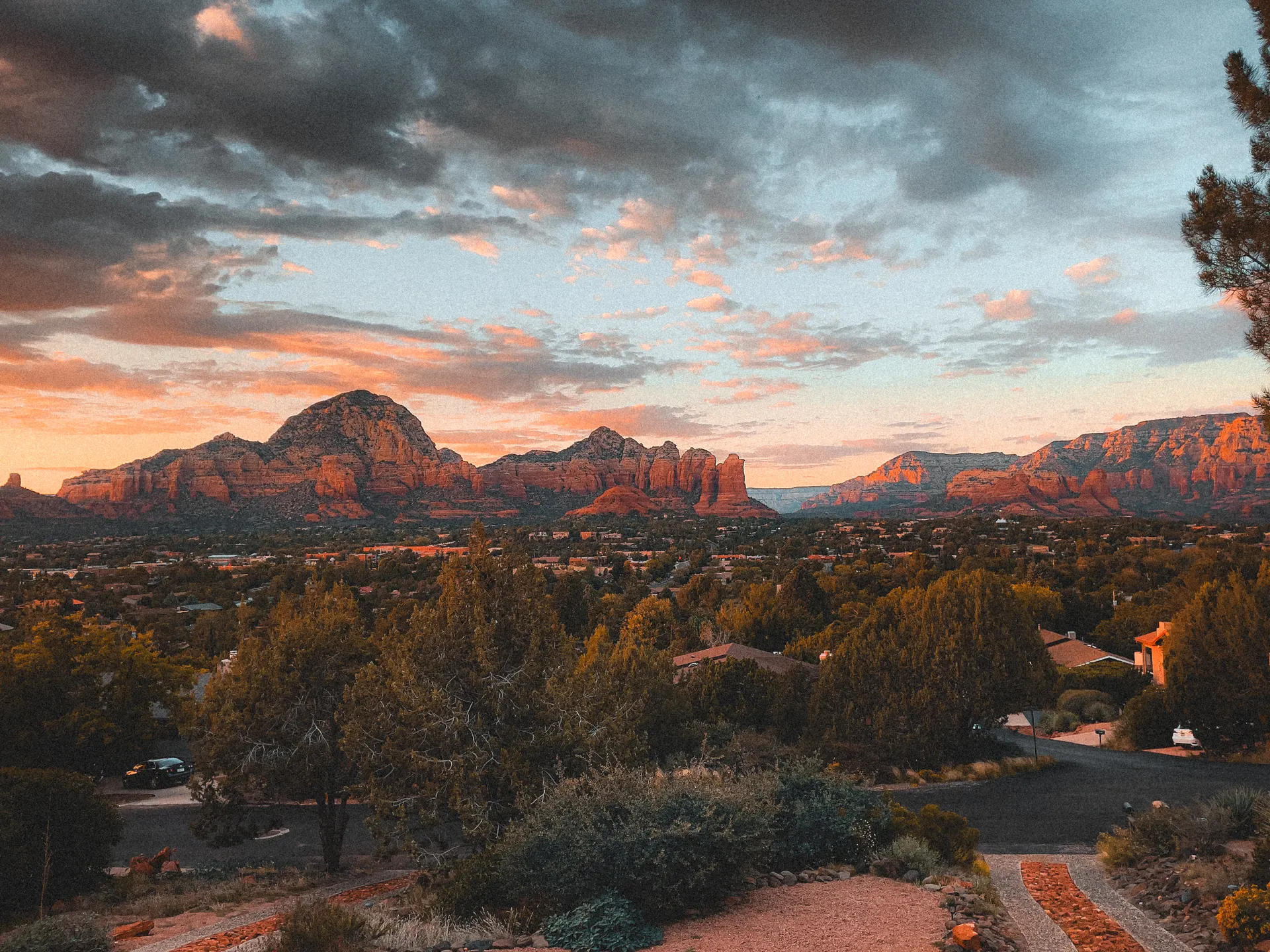
Saguaro National Park protects the densest stands of the giant saguaro cactus on Earth, the towering, many-armed symbol of the American Southwest. Unusually, the park comes in two separate halves that flank the city of Tucson: the Tucson Mountain District (West) and the Rincon Mountain District (East), roughly 30 to 45 minutes apart across town.
This 3-day itinerary chases the best Saguaro National Park hikes in both districts, based in Tucson. You'll start in the West among the thickest cactus forest at Valley View Overlook and Signal Hill's ancient petroglyphs, climb to Wasson Peak for the big panorama, then cross to the East for the Cactus Forest Loop Drive and the desert oasis of Bridal Wreath Falls.
November through March is the season to hike here, mild days, cool mornings, and the desert at its most comfortable. From late spring into summer the heat is genuinely dangerous, so any longer hike means starting at dawn and carrying far more water than you think you need.
There is no lodging inside either district, you base in Tucson and drive in each day. Summer highs regularly top 105°F, so longer hikes like Wasson Peak should start at dawn; carry at least a gallon of water per person, watch for rattlesnakes, and never grab a cactus for balance. The $25 vehicle pass covers both districts for 7 days, or use an America the Beautiful pass.
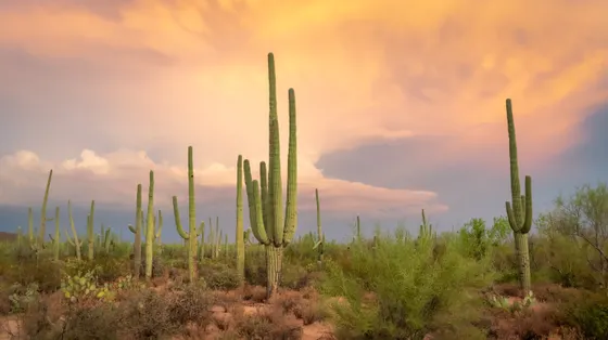


West District · Valley View Overlook, Signal Hill & the Bajada Loop
Start in the Tucson Mountain District (West), where the saguaro forest is at its thickest. Drive the scenic Bajada Loop Drive, a graded dirt loop that threads through the densest cactus stands, and walk the short Desert Discovery Nature Trail (about 0.5 mile, paved and easy) for a gentle introduction to Sonoran Desert plants.
Stretch your legs on the Valley View Overlook Trail (about 0.8 mile round trip), which ends at a sweeping view across Avra Valley framed by saguaros. Finish at Signal Hill, a short half-mile walk up to a cluster of ancient Hohokam petroglyphs pecked into the rocks, best in late-afternoon light. The Tucson Mountains glow at sunset, so linger before driving back into town.
- Bajada Loop DriveScenic graded dirt loop · densest saguaro stands · trailheads along the way
- ~0.8 mi RT · easy · Avra Valley view through the cactus
- ~0.5 mi RT · easy · ancient Hohokam rock art · best late light
- Stay in TucsonNo lodging in the park · base in Tucson · 30 min to the West district
- The Bajada Loop Drive is graded dirt, passable in most cars when dry, but slow and washboarded; allow extra time.
- Signal Hill is best in late-afternoon light, when the low sun makes the petroglyphs and the Tucson Mountains glow.
- The Arizona-Sonora Desert Museum sits right next to the West district and pairs naturally with this day if you want an add-on.

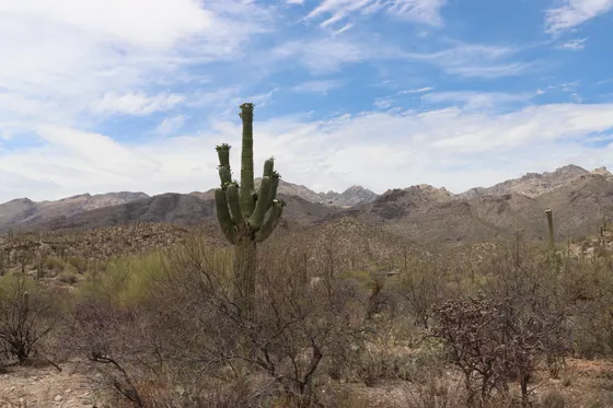
West District · Wasson Peak via King Canyon

Today is the big one. Wasson Peak (4,687 ft) is the high point of the Tucson Mountains and the best summit hike in the West district. The most direct route climbs the King Canyon Trail to the summit, roughly 7 miles round trip with about 1,800 feet of gain, strenuous, passing an old mine and rising through saguaro-studded slopes to a 360-degree view over Tucson, Avra Valley, and the surrounding ranges.
For a longer, more scenic line, the Hugh Norris Trail follows the ridgeline to the same summit (about 10 miles round trip) with near-constant views. Either way, start at first light: there is little shade, and from late spring through summer the heat is genuinely dangerous. Carry at least a gallon of water per person and turn around if you run low.
- ~7 mi RT · ~1,800 ft · strenuous · 360-degree summit view
- ~10 mi RT · ridgeline route to Wasson Peak · constant views
- Carry a gallon of water eachLittle shade · start at dawn · turn around if you run low
- Stay in TucsonSecond night in Tucson · short drive back across town tomorrow
- Wasson Peak has almost no shade. In warm months start at first light and carry at least a gallon of water per person.
- King Canyon is the shorter route (about 7 mi); Hugh Norris (about 10 mi) is longer but follows the ridgeline with constant views.
- Rattlesnakes are active March through October. Watch where you step and never reach onto rocks you can't see.
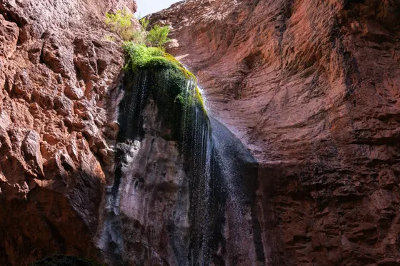
East District · Cactus Forest Loop & Bridal Wreath Falls
Cross Tucson to the Rincon Mountain District (East), a 30 to 45 minute drive depending on traffic. Begin with the Cactus Forest Loop Drive, an 8-mile paved one-way scenic loop through classic saguaro forest with pullouts, picnic spots, and short trailheads. Warm up on the easy Freeman Homestead Trail (about 1 mile loop) or the flat Cactus Forest Trail near the Mica View area.
For the day's feature hike, take the Douglas Spring Trail to Bridal Wreath Falls, about 5.8 miles round trip, moderate, climbing gently to a seasonal desert waterfall that runs best after winter rains or snowmelt (it can be dry in summer). Strong hikers can swap in the steeper Tanque Verde Ridge Trail for longer ridge views; the full Mica Mountain traverse is a serious backcountry day or overnight and is beyond this itinerary. Getting home: Tucson International Airport (TUS) is about 30 minutes from the East district, an easy departure-day drive.
- Cactus Forest Loop Drive8 mi paved one-way scenic loop · pullouts · short trailheads
- Guided e-bike tour · an easy way to ride the paved scenic loop
- ~1 mi loop · easy · interpretive desert walk
- ~5.8 mi RT · moderate · seasonal desert waterfall
- Getting home: Tucson airport (TUS)~30 min from the East district · easy departure-day drive
- The two districts sit on opposite sides of Tucson, roughly 30 to 45 minutes apart, plan the cross-town drive into your morning.
- Bridal Wreath Falls is seasonal: it runs best after winter rains or snowmelt and can be bone-dry in summer.
- Tanque Verde Ridge is a steeper alternative with long views; the full Mica Mountain hike is a serious backcountry day, beyond this trip.

Now build your Saguaro trip.
You've seen all three days. Open the free drag-and-drop planner and tune it for your dates, your pace, and how much desert sun you want to take on.
What we actually learned in the desert.
Hike November through March
The cool season brings mild days and comfortable mornings. From late spring into summer, highs regularly top 105°F and longer hikes become genuinely dangerous, start any real hike at dawn and be off the trail by late morning.
Carry far more water than you think
There is little to no shade and no water on most trails. Bring at least a gallon per person for a hike like Wasson Peak, sip steadily, and turn around if you drop below half. Salty snacks help with electrolytes.
The two districts are 30–45 minutes apart
Saguaro East (Rincon Mountain) and Saguaro West (Tucson Mountain) flank opposite sides of Tucson. You can't see both in a single morning without a long cross-town drive, plan a full day for each side.
Watch for rattlesnakes and cactus
Rattlesnakes are active March through October, watch where you step and never reach onto rocks you can't see. Never grab a cactus for balance; cholla spines in particular are miserable to remove. Carry tweezers.
There is no lodging inside the park
Both districts are day-use only with no hotels or developed campgrounds at the road, so you base in Tucson and drive in. The city has plentiful lodging and sits between the two districts.
Pair the West with the Desert Museum
The Arizona-Sonora Desert Museum sits right beside the Tucson Mountain District and is one of the best desert zoos and botanical gardens anywhere. It pairs naturally with a West-district day if you want a non-hiking add-on.
Everything you'll actually want to know.
Ready to go? Get your
Saguaro hikes route.
Both districts mapped, trail names and mileages, the cross-town drive, the dawn-start summit, and where the seasonal falls actually run, every detail you need to hike Saguaro from Tucson without backtracking.
Instant book · Free cancellation · Secure payment via Stripe


Planning this trip?
Save it, share it with your crew, or find travelers heading the same way.

Liked this itinerary?
What other travelers are saying
Be the first to leave a tip or question for the next traveler.