Ouachita National Recreation Trail:
A Section-Hike Itinerary
Four days section-hiking the Ouachita National Recreation Trail (the OT): Pinnacle Mountain near Little Rock, the Flatside Wilderness and Forked Mountain, Rich Mountain above Queen Wilhelmina, and the Talimena Scenic Byway overlooks.
Free interactive planner · drag & reorder your days, add stops, map it in minutes
Build your own Ouachita Trail section hike, drag, reorder & map it.
Drag stops between days, swap ridge sections, and add your own trailheads and Talimena Byway overlooks with the place search. The live map and drive times recalculate as you go, and because the OT is point-to-point we will flag the long shuttle legs so you can plan a car drop.
Opens a side panel · reorder days, add custom stops, see your route live
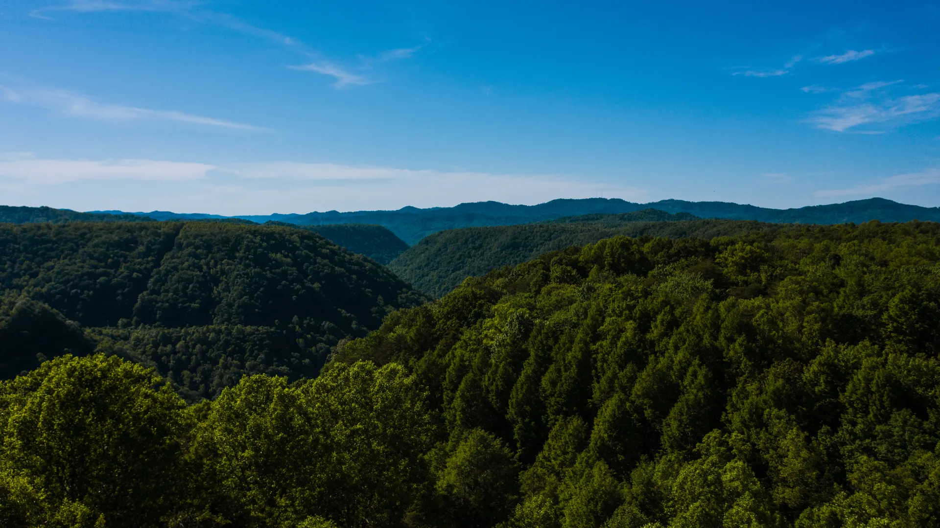
One long ridge trail, east to west, across the Ouachitas.
The Ouachita National Recreation Trail, known to hikers as the OT, runs about 223 miles east to west across the Ouachita Mountains, from Pinnacle Mountain State Park near Little Rock, Arkansas, to Talimena State Park in Oklahoma. Most of it threads through the Ouachita National Forest, the oldest national forest in the South.
What makes the OT unusual is its grain: unlike almost every other range in the region, the Ouachitas run east to west rather than north to south, which gives the trail long, quiet forested ridge walks instead of constant climbs and drops. This 4-day route samples the best of it: Pinnacle Mountain near Little Rock, the Flatside Wilderness and Forked Mountain, Rich Mountain (the high point) above Queen Wilhelmina State Park, and the Talimena National Scenic Byway overlooks at the western end.
Spring brings wildflowers and dogwoods, and fall brings some of the best leaf color in the South. Summers are humid and buggy, with ticks, chiggers, and copperheads, so most hikers come in the shoulder seasons. The trail is point-to-point with free, first-come shelters and primitive campsites and no permit for most of it, so the main logistics are arranging a shuttle and treating your water.
The OT is point-to-point, so the single most important thing to arrange is a shuttle or a two-car drop between your start and end trailheads. Shelters and primitive campsites are free and first-come, with no permit for most of the trail, so you cannot reserve a spot. Queen Wilhelmina State Park Lodge on Rich Mountain is a popular base near the western end and fills on fall-color weekends, so book early; otherwise base in Mena, Hot Springs, or Little Rock and drive to your section.


The east end: Pinnacle Mountain near Little Rock
Start where the OT does, at its eastern terminus in Pinnacle Mountain State Park, only about 20 minutes northwest of Little Rock (LIT). The cone-shaped Pinnacle rises straight out of the Arkansas River valley, and the surrounding park is laced with trail that links into the western end of the Ouachita National Recreation Trail.
Warm up on the park trails and the first forested miles of the OT itself, getting a feel for the long, rolling ridge walking that defines the whole trail. Pick up water, check the latest trail conditions, and sort your shuttle plan before you head deeper west. This is the most accessible end of the trail, so it is the easiest place to start a section hike and the simplest to reach without a long drive.
- Pinnacle Mountain & the OT east endEastern terminus near Little Rock · cone-shaped peak · ridge warm-up
- Current trail conditions, closures & maps for the OT
- Treat all your waterHumid, buggy in summer · filter or treat creek and spring water
- Base in Little RockClosest city to the east end · easy LIT airport access
- The eastern terminus at Pinnacle Mountain State Park is the easiest end of the OT to reach, about 20 minutes from Little Rock and its airport (LIT).
- The OT is point-to-point, so settle your shuttle or two-car plan before your first section. There is no permit, but there is also no easy loop back to your car.
- Check current conditions and grab maps through the Ouachita National Forest before you start, since storms and burns can close stretches of trail.
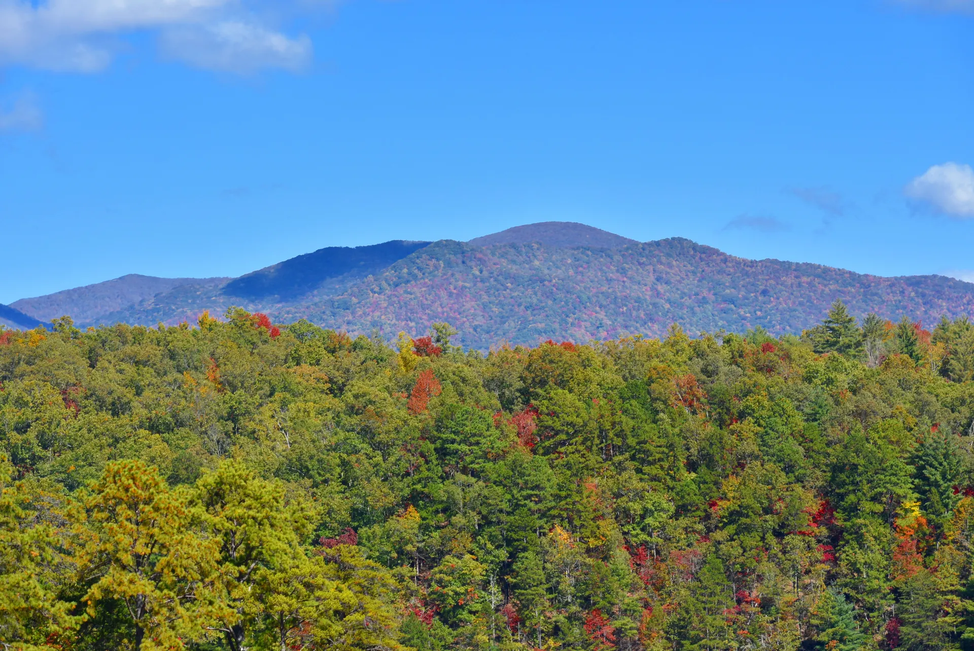
The Flatside Wilderness & Forked Mountain

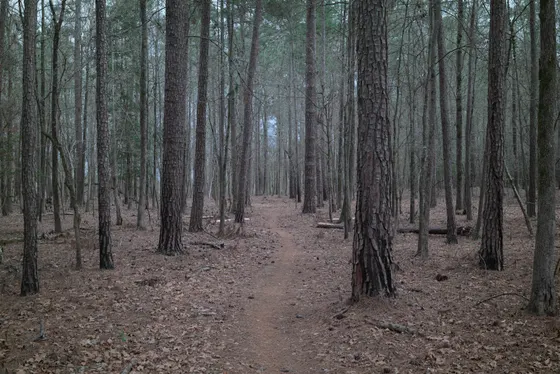
Move west into the heart of the Ouachita National Forest and the Flatside Wilderness, one of the wildest and most scenic stretches the OT passes through. The trail rolls along quiet forested ridges with long views, and side trails climb to Flatside Pinnacle and look out toward the distinctive cone of Forked Mountain.
This is classic OT walking: more sustained ridge mileage than big climbs, deep hardwood forest, and very few other people. Spring fills the understory with dogwoods and wildflowers, while fall turns the whole ridge to color. Plan to camp at one of the free, first-come shelters or primitive sites along this section, and carry enough water between sources, since springs can run low in late summer and fall.
- Flatside Wilderness & Flatside PinnacleWildest scenic stretch on the OT · short climb to big views
- Forked Mountain viewsThe distinctive cone seen from the Flatside ridge
- Camp at a trail shelterFree, first-come shelters & primitive sites · no permit, no reservation
- Carry water between sourcesSprings can run low in late summer and fall · treat everything
- The Flatside Wilderness is one of the most scenic parts of the whole OT, with a short side climb to Flatside Pinnacle for the big view.
- Shelters and primitive campsites along the trail are free and first-come, so carry a plan B if a shelter is full. There is nothing to reserve.
- Water sources are spread out and can run low in late summer and fall. Carry enough between reliable creeks and treat or filter everything you collect.
Rich Mountain & Queen Wilhelmina
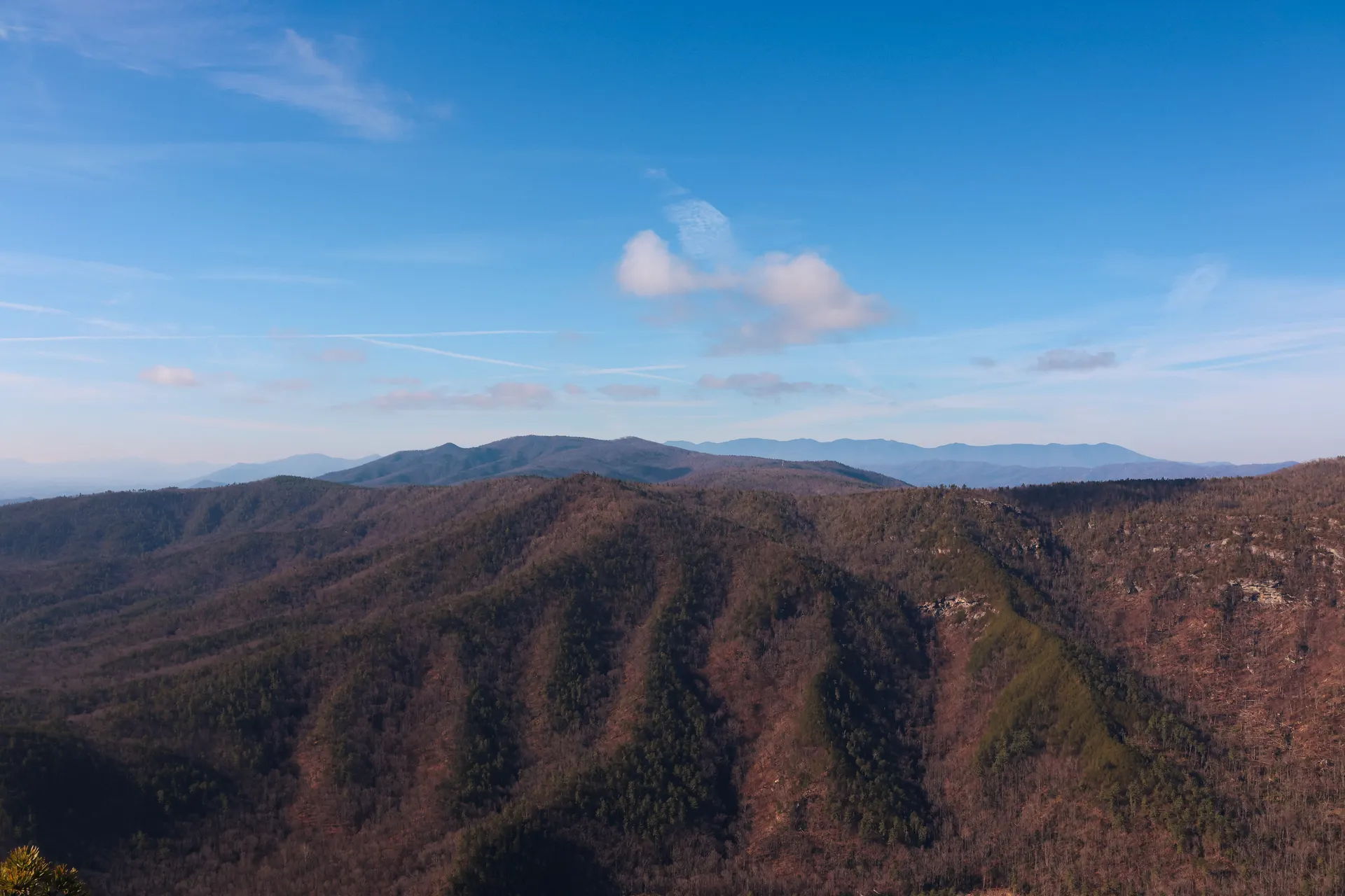
Head to the western end of the trail for its high point. Rich Mountain is the highest point on the OT, and the historic Queen Wilhelmina State Park sits right on its crest, with a lodge perched on the ridge and big views over the surrounding ranges. It makes a perfect base near the western half of the trail.
Walk the OT sections along and below the Rich Mountain crest, where the long east-west ridge gives you sustained high walking with views on both sides, something you rarely get on a forested trail. The lodge is popular on fall-color weekends, so book ahead if you want a night up top, or base down in Mena just below the mountain and drive up. Either way, this is the scenic climax of the route before you finish at the byway.
- Rich Mountain · the OT high pointHighest point on the trail · long ridge walking with views both sides
- Queen Wilhelmina State Park & LodgeHistoric lodge on the Rich Mountain crest · book ahead in fall
- Maps and conditions for the Rich Mountain sections of the OT
- Base in Mena, ArkansasTrail town just below Rich Mountain · supplies and lodging
- Rich Mountain is the high point of the OT, and Queen Wilhelmina State Park sits right on the crest, so it is the obvious base for the western half of the trail.
- The Queen Wilhelmina Lodge is popular and sells out on fall-color weekends. Book early, or stay down in Mena and drive up to the ridge each day.
- The east-west grain of the Ouachitas means long stretches of high ridge walking with views on both sides, rare for a forested trail, so save time for it.

The Talimena Scenic Byway & the west terminus

Finish along the Talimena National Scenic Byway, which parallels the western end of the OT across Rich Mountain toward Oklahoma. The byway gives easy trailhead access and a string of overlooks, so you can hike short OT segments between pullouts and link your walking to the best views without committing to a full thru-section.
Follow the trail to its western terminus at Talimena State Park in Oklahoma, the far end of the 223-mile OT. Getting home: from this end it is a manageable drive to Fort Smith (FSM) or a longer haul back across the range to Little Rock (LIT), so plan your shuttle back to your start car and fuel up in Mena before the drive out. Time this last day for late afternoon light on the overlooks if you can.
- Talimena National Scenic BywayParallels the west end of the OT · easy trailhead access & overlooks
- OT western terminus · Talimena State ParkThe Oklahoma end of the 223-mile trail · finish here
- Getting home: Fort Smith or Little RockFSM is closer to the west end · LIT is back across the range
- Byway and trail conditions across the western Ouachitas
- The Talimena National Scenic Byway parallels the western OT, so you can hike short trail segments between overlooks and still bag the best views.
- The western terminus is at Talimena State Park, Oklahoma. Fort Smith (FSM) is the closer airport to this end; Little Rock (LIT) is back across the range.
- Fuel up and resupply in Mena before the drive out, and confirm your shuttle plan so you are not stranded at the far end of a point-to-point trail.
Now build your Ouachita Trail section hike.
You have seen all four days. Open the free drag-and-drop planner and tune it for your dates, your pace, and whether you base in Mena, Hot Springs, or Little Rock between sections.
What we actually learned on the OT.
Arrange a shuttle, it is point-to-point
The OT runs one way across the range, so there is no loop back to your car. Use two cars and drop one at each end, or arrange a shuttle. Build your sections around where you can leave and pick up vehicles.
No permit for most of the trail
Most of the Ouachita National Recreation Trail needs no permit and no reservation. Shelters and primitive campsites are free and first-come, so carry a tent as a backup in case a shelter is already taken when you arrive.
Treat your water and watch the gaps
Filter or treat every source. Water is reliable through much of the trail but spreads out and can run low in late summer and fall, so know where your next creek or spring is and carry enough to cover the dry stretches.
Go in spring or fall
Spring brings dogwoods and wildflowers; fall brings some of the best leaf color in the South. Summers are hot and humid with heavy bug pressure. The shoulder seasons are far more pleasant for the long ridge walking the OT is built on.
Watch for ticks, chiggers & copperheads
Warm-season hiking in the Ouachitas means ticks and chiggers in the brush and copperheads on the trail. Treat clothing, check yourself daily, watch where you put your hands and feet, and give snakes room to move off the trail.
Base in a trail town between sections
For a section hike, base in Mena near Rich Mountain, in Hot Springs, or in Little Rock near the eastern end, and drive to each section. Queen Wilhelmina Lodge on Rich Mountain is the standout on-trail stay and books up on fall weekends.
Everything you'll actually want to know.
Ready to go? Get your
Ouachita Trail section hike.
Trailheads and mileages, the on-trail lodge on Rich Mountain, shuttle logistics for a point-to-point trail, the Talimena Byway overlooks, and the season and safety notes you need to hike the OT well.
Instant book · Free cancellation · Secure payment via Stripe
Planning this trip?
Save it, share it with your crew, or find travelers heading the same way.

Liked this itinerary?
What other travelers are saying
Be the first to leave a tip or question for the next traveler.